Chapter Notes: Globes and Maps


Let us learn about Globe!
- Every morning we see the sun rising in the east. It comes out like a huge ball of fire. At night, there are moon and millions of other brightly shining stars that seem hanging in the sky.
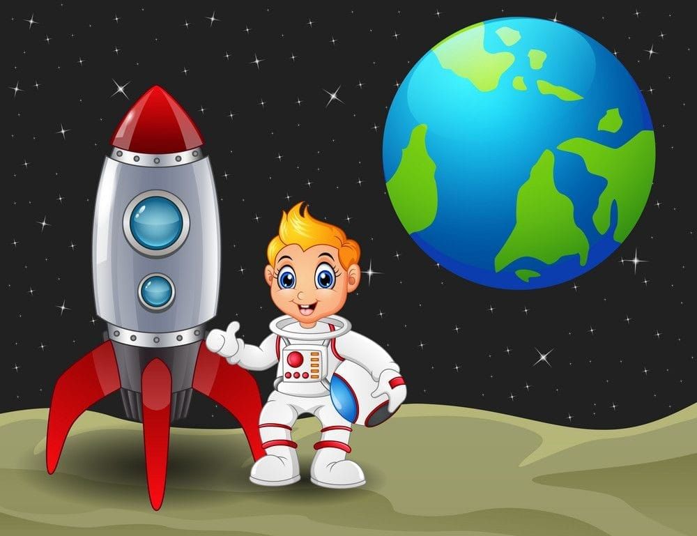
- Astronauts who went up in space could see our earth just like the heavenly bodies that we see from the earth. Pictures of the earth taken from space show that it is round like a ball.
 The images of earth from space show that earth is Round
- For purposes of our study of the earth, we make spherical models.
What is Globe?
A spherical model of the earth is called Globe.
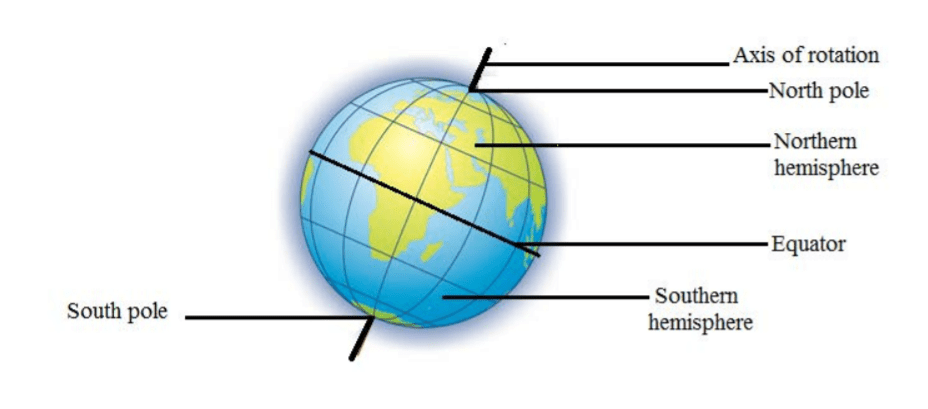
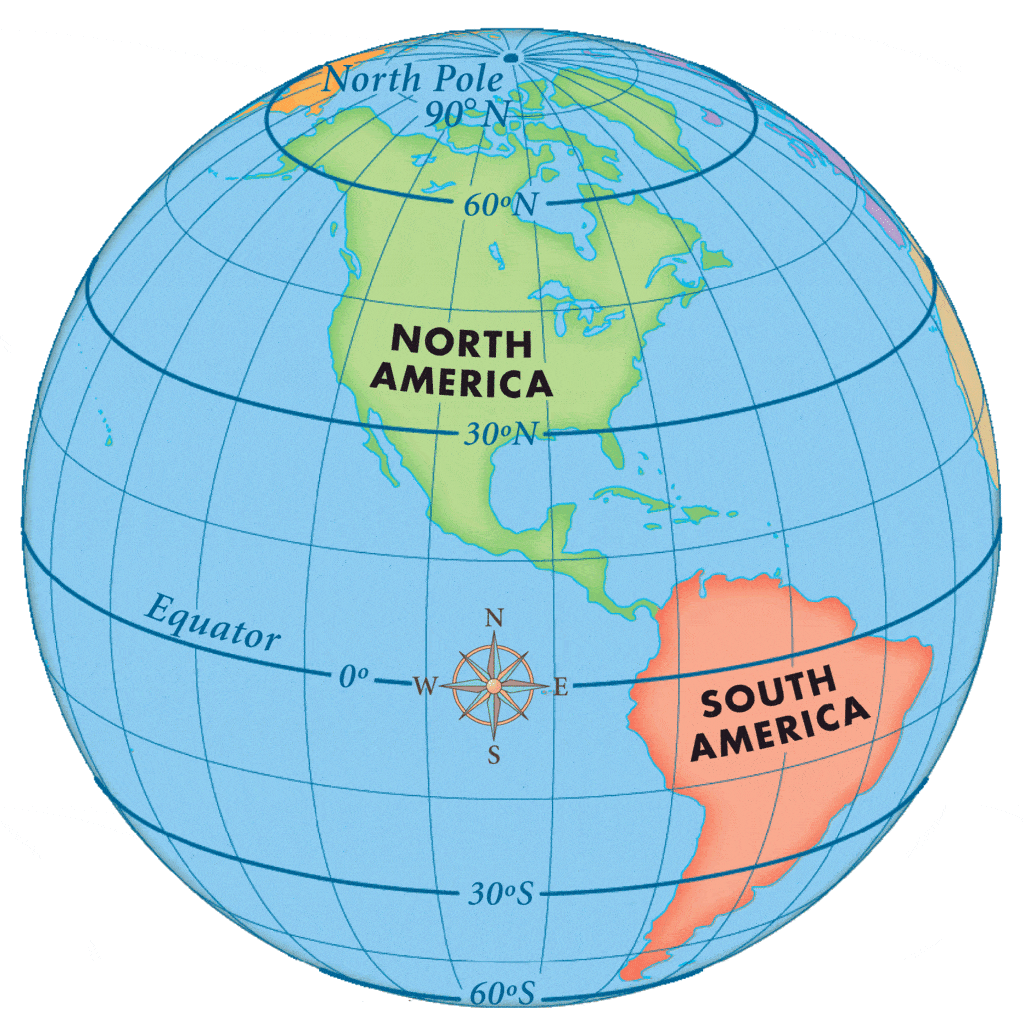
- The two extreme ends of the spherical model are marked with the North and South poles. An axis passes through the poles.
 North Pole and South Poles of Globe
- The axis is mounted on a horizontal base at an inclination of 23.5° to the vertical. The sphere can rotate around the axis.
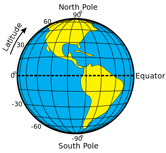
- Midway between the two poles, a circle is drawn that divides the globe into two hemispheres.
- The upper hemisphere is called the Northern hemisphere and the lower is called the Southern hemisphere.
- This circle is called the Equator. This is the 0° Latitude. The other lines or circles running parallel to the Equator grow smaller and smaller as we move towards north or south.
- These are drawn at the gap of 1° each. The furthest parallel are 90° N and 90° S, each showing the location of the North Pole and the South Pole respectively.
Try yourself: Earth is represented nearly perfect by
Lines of Latitude on Globe
Lines of latitude (also called parallels) circle Earth parallel to the Equator.
 Lines of Latitude on Globe also called parallels
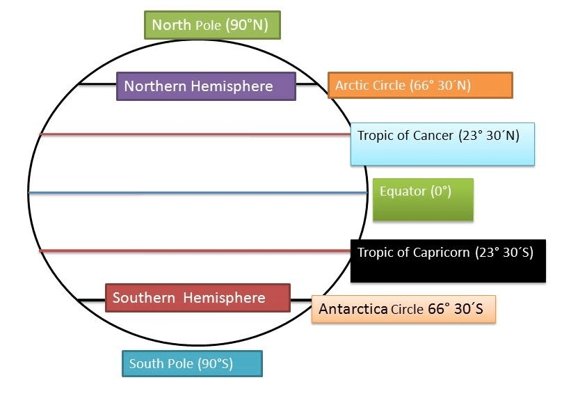
Important Latitudes of Earth
- North Pole - 90° N
- Arctic Circle - 66 ½° N
- Tropic of Cancer - 23 ½° N
- The Equator - 0°
- Tropic of Capricorn - 23 ½° S
- Antarctic Circle - 66 ½° S
- South Pole - 90° S
 Important Latitudes of Earth
Try yourself: On globe, Equator represents the
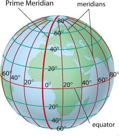
Lines of Longitude on Globe
Lines of longitude run between the North Pole and the South Pole. These lines are also called meridians.
 Lines of Longitude of Globe also called Meridians
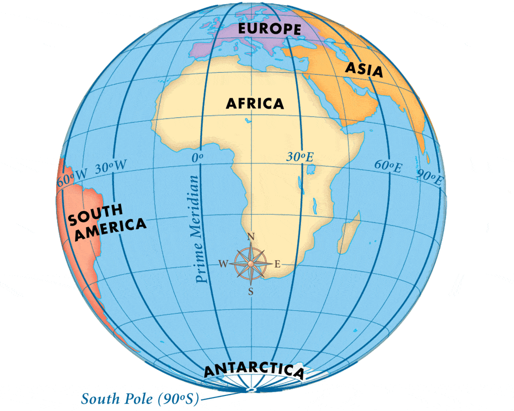
- Lines of Longitudes are also called Meridians. There are 360 meridians in all. The meridian running through Greenwich Observatory near London, UK, is taken as the 0° Longitude or Prime Meridian.
- All the other meridians are marked off from this point, drawn at the interval of 1 degree. There are 180 meridians east of the Prime Meridian and 180 meridians west of it.
- The meridians in the east are marked as E and those in the west are marked W to let us know their position. The 180° E and 180° W are the same lines. It coincides with the Date Line.
The Important Longitudes are:
- Prime Meridian 0° Longitude
- The International Date Line 180° E or 180° W
 Prime Meridian
- The meridians and the latitudes cross each other at 90° forming grids. These grids help us in many ways, specially locating places on the globe. You will learn more about them later.
- But remember that these lines are on the globe and on the map. Actually, there are no such lines on the surface of the earth. These are imaginary lines to help us in describing various physical and human activities and to make our studies easy about the earth. These are one of the tools used by us.
Keep in Mind!
Before proceeding further to Maps we need to keep in mind the following things:
- Globe is the miniature earth.
- The axis which passes through it is the axis of rotation.
- The axis is tilted at an angle of 23½° to the vertical.
- The axis passes through the North Pole and the South Pole.
- Longitudes and Latitudes are the imaginary lines that help us in many ways.
- The most important of these are 0° Meridian or Greenwich Meridian or Prime Meridian, 180° E or 180° W or Date Line, Arctic Circle, Tropic of Cancer, Equator, Tropic of Capricorn, Antarctic Circle.
Let us learn about Maps now!
Why do we Need Maps?
- Spherical models are difficult to carry. More so, if they are made in big sizes. So we make flat maps.
- Maps can be folded and easily carried or hungover classroom walls. Within the maps, we use different colour codes and symbols to make it easy for us to get information about places and their location.
- In this Unit, we shall learn about Globe and Maps and how they help us as tools in the study of Lands and People.
Disadvantages of Globe
- A Globe is the nearest representation of our earth. However, it is not the most convenient tool in our study of places and people.
- It is difficult to carry. It cannot be included in a book. The globe cannot be folded. It is of little use if we were to study a small part of the earth in greater detail.
- A globe can neither be rolled nor carried in a small briefcase.
What are Maps?
These difficulties led to creation of maps. Maps are flattened pieces of the earth's surface as shown on the globe. The art of making maps is known as Cartography.
- Distortions occur when spherical portions of the globe are flattened. The cartographers try to minimize the distortions.
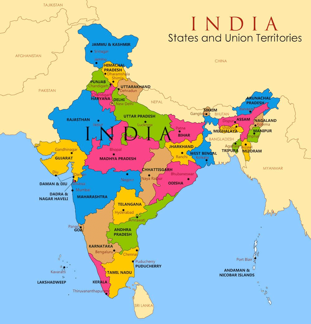 Political Map of India
- Maps are important for many more people, besides students and teachers. For the engineer designing a railway track or a highway, it is important to know about the position of rivers, mountains, and other physical obstructions that would come in the way.
- The town planners also need such information. A physical map would show mountain ranges, hills, rivers, plateaus, plains, and valleys. A political map would show the boundaries of different countries within a Continent or of different States within a country.
A collection of maps is called ATLAS. An atlas would be of great help in planning tours and even small excursions. But that is possible only if we understand the language of the maps.
 Atlas: Collection of Maps
Directions
- We are all familiar with the four directions-EAST, WEST, NORTH, and SOUTH.
- If you hang the map of India on a wall, the Himalayas at the top would be in the NORTH direction.
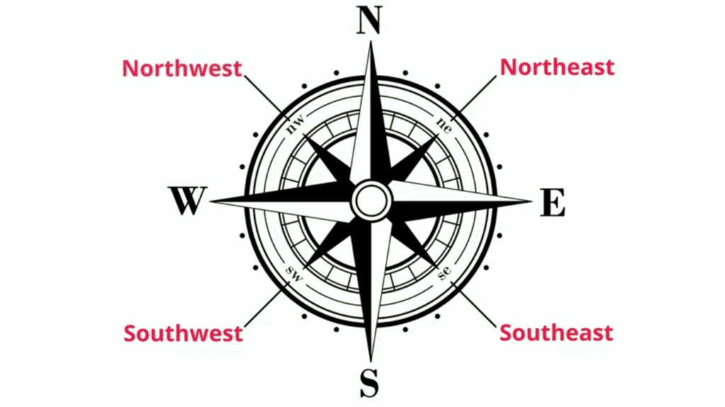 Directions & Sub-Directions
- The Indian Ocean at the bottom would be the SOUTH. The Bay of Bengal would be in the EAST while the Arabian Sea would be in the WEST direction.
- Besides these, there are sub-directions. NORTHEAST lies between the north and east.
- The other sub directions are SOUTH-EAST, SOUTH-WEST, and NORTHWEST. This uniform pattern is followed in naming directions all over the world.
Scale
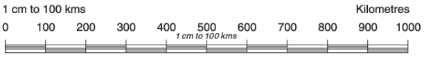
- All maps are drawn in a size very much smaller than the actual size. The distance between New Delhi and Lucknow may be about 500 kilometers.
- On the map, the distance between these two cities may be just two centimeters. The ratio between the map distance and the ground distance is called the SCALE of the map.
- In the above example, the scale would be 1 cm: 250 km.
- The scale is represented by a line bar. The above line bar shows a line scale in which 1 cm on the map represents 100 km on the ground.
Symbols on Map
- All maps use certain accepted symbols and colour codes. Thick lines in dashes and dots mark the boundary of a country.
- A small circle marks the location of a city. The capital cities are shown with a circle within an outer circle.
- The boundaries of States within the country are also shown through dash and dot. But the lines are not that thick.
- In a number of conventional map signs, figures and pictures are used to show places like roads, bridges, airports, railway tracks and places of worship, etc.
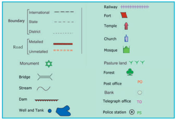 Different Signs and Symbols used on the Maps
- Rivers, canals, coastlines, and lakes, etc. are shown through blue lines. Roads are shown in red lines.
- Railway tracks are shown in black. In physical maps, mountains are shown in brown are taller than the other mountains, the deeper is the brown shade. The seas are shown in blue.
- The depth at any particular place is indicated by how dark is the shade of blue. The shallow sea along the coasts may be shown in very light blue. The high seas may be in deep blue. The plains are shown in green.
- Maps are also used to give a visual description to feature like crops grown, amount of rainfall, vegetation, occurrence of minerals, etc.
Keep in Mind!
Always keep in mind the following things about maps:
- Maps are drawn using the four fixed or cardinal directions. These are north, south, east and west.
- On a map, east is always on the right, west is on the left, north is at the top, and south is at the bottom.
- Symbols are small pictures which help us to identify places.
- Colours help us identify features.
FAQs on Chapter Notes: Globes and Maps
| 1. What's the difference between a globe and a map for Class 5 Social Studies? |  |
| 2. Why do we use lines of latitude and longitude on maps and globes? | |
| 3. How do map symbols and colours help us read maps correctly? | |
| 4. What does scale on a map mean and why is it important? | |
| 5. How do you identify different types of maps like political maps, physical maps, and thematic maps? | |


