Worksheet: The Southern Plateaus - 1

Q1: Fill in the blanks.
(i) Hilly regions to the east and west of the Southern Plateau are called _________
(ii) Chambal has a ____________flow.
(iii) River _____________ divides the Plateau region into two parts.
(iv) ___________Lands are also called Table Lands.
(v) Rivers _________ and _________ join the Arabian Sea.
(vi) The ______________ in Karnataka is the highest waterfall in India.
(vii) _____________ is the highest peak of Deccan Plateau region.
(viii) The annual ________________ of Puri is very famous.
(ix) Lavani is a popular dance form of _____________.
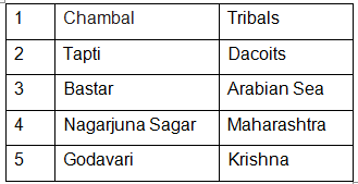
Q2: Match the following.
Q3: True or False.
(i) The Central Highlands include the Malwa Plateau and the Chotanagpur Plateau.
(ii) Most of the India's coal is mined from the Damodar valley.
(iii) Kanyakumari marks the southernmost tip of the southern plateau region.
(iv) The Plateau is not at all important for Indian economy.
(v) The rivers in the Plateau region are rain fed rivers.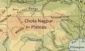
Q4: Multiple Choice Questions (MCQs).
(i) What is the shape of the southern plateaus?
(a) Triangular
(b) Round
(c) Square
(d) Rectangle
(ii) Which of these river do not flow through the central highlands?
(a) Son
(b) Chambal
(c) Ganga
(d) Betwa
(iii) _______ is cultivated in Maharashtra.
(a) Cotton
(b) Saffron
(c) Cardamom
(d) Basmati rice
(iv) The Andaman islands are separated from the Nicobar islands by the
(a) Bay of Bengal
(b) Arabian sea
(c) Indian sea
(d) Ten degree channel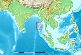
Q5: Answer the following questions.
(i) What is the most common source of irrigation in the Plateau region?
(ii) Which rivers drops down the hills to form the famous Jog Falls?
(iii) Why do rivers in the Plateau region go dry in summers while the rivers in the northern plains do not?
(iv) List five minerals found in the Chota Nagpur Plateau.
(v) Which are the main crops grown in Maharashtra?
(vi) What do people like to eat in Tamil Nadu?
(vii) Which are the popular tourist attractions of Hyderabad?
(viii) Write a short note on the state of Jharkhand.
(ix) Which hill ranges surrounded the Deccan plateau?
(x) Where are the Andaman and Nicobar islands located?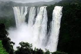
You can find Worksheets Solutions here: Worksheet Solutions: The Southern Plateaus - 1
FAQs on Worksheet: The Southern Plateaus - 1
| 1. What are the main features of the Southern Plateaus that I need to know for my exam? |  |
| 2. Which rivers flow through the Southern Plateaus and why are they important? | |
| 3. What makes the climate of the Southern Plateaus different from other Indian regions? | |
| 4. How does the terrain and elevation of the Southern Plateaus affect human settlement there? | |
| 5. What are the main mineral resources found in the Southern Plateaus worksheet topics? | |