Consider the following statements: (2023) Statement-I: India, despite having uranium deposits, depends on coal for most its electricity production. Statement-II: Uranium, enriched to the extent at of least 60%, is required for the production of electricity. Which one of the following is correct in respect of the above statements? (a) Both Statement-I and Statement-II are correct and Statement-II is the correct explanation for Statement-I (b) Both Statement-I and Statement-II are correct and Statement-II is not the correct explanation for Statement-1 (c) Statement-I is correct but Statement-II is incorrect (d) Statement-I is incorrect but Statement-II is correct
Solution:
Ans: (c)
In India, power is generated from conventional (Thermal, Nuclear & Hydro) and renewable sources (Wind, Solar, Biomass etc).
However, Major production of Electricity is achieved through coal, a thermal power plant which is around 75% of the total power generation. Hence, statement-I is correct.
However, uranium enriched to the extent of at least 60% is not required for the production of electricity. Uranium enrichment is the process of increasing the concentration of uranium-235, which is the fissile isotope of uranium that can sustain a nuclear chain reaction.
For civilian nuclear power plants, uranium is typically enriched to about 3-5% of uranium-235, which is sufficient for light water reactors that are commonly used for electricity generation. Hence, statement-II is not correct.
Hence, option (c) is correct.
Question 2:
Consider the following statements: (2023)
Jhelum River passes through Wular Lake.
Krishna River directly feeds Kolleru Lake.
Meandering of Gandak River formed Kanwar Lake.
How many of the statements given above are correct? (a) Only one (b) Only two (c) All three (d) None
Solution:
Ans: (a)
Wular Lake is the 2nd largest fresh-water lake of Asia. It is sited in the Bandipora district in Jammu and Kashmir, India. Main source of water for Wular Lake is
River Jhelum. This lake also has a small island in its centre called the 'Zaina Lank'. This island was constructed by King Zainul-Abi-Din. Hence, statement 1 is correct.
Wular Lake is also said to be a remnant of Satisar Lake that existed in ancient times. The premises of this lake also form a popular sunset point.
Kolleru, one of the largest freshwater lakes in India, (it was designated a sanctuary in October 1999) is situated between the Krishna and West Godavari districts of the state.
The Krishna River does not directly feed the Kolleru Lake. The Kolleru Lake is fed by two seasonal rivers, Budameru and Tammileru, which are tributaries of the Krishna River. Therefore, the Krishna River indirectly feeds the Kolleru Lake through its tributaries. Hence, statement 2 is NOT correct.
The meandering of Gandak River did not form the Kanwar Lake, which is a freshwater oxbow lake located in Begusarai district of Bihar, India.
The Kanwar Lake was formed by a cut-off meander of an old channel of Burhi Gandak River. The Burhi Gandak River flows parallel to the eastern side of the Gandak River through an old channel. Hence, Statement 3 is NOT correct.
Question 3:
Consider the following pairs: (2023)
How many of the above pairs are correctly matched? (a) Only one pair (b) Only two pairs (c) All three pairs (d) None of the pairs
Solution:
Ans: (b)
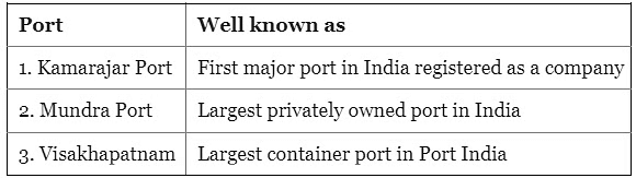
Kamarajar Port, formerly known as Ennore Port, is the first major port in India registered as a company and is the only corporatized major port in India. Hence, pair 1 is correctly matched.
It was declared as the 12th major port of India in March 1999 and incorporated as Ennore Port Limited under the Companies Act, 1956 in October 1999.
It is located on the Coromandel Coast about 24 km north of Chennai Port, Tamil Nadu.
Mundra Port is India's largest commercial port located on the northern shores of the Gulf of Kutch near Mundra, Kutch district, Gujarat. It is owned and operated by Adani Ports and Special Economic Zone Limited (APSEZ), which is a part of Adani Group.
It was established in 1998 as a private sector port and became operational in October 2001. It handles various types of cargo such as containers, bulk, break- bulk, liquid, chemicals, automobiles, etc. Hence, pair 2 is correctly matched.
Visakhapatnam Port, located on the east coast of India in Andhra Pradesh, is not the largest container port in India. It is one of the oldest and largest major ports in India, handling various types of cargo such as iron ore, coal, petroleum products, fertilisers, containers, etc.
The largest container port in India is Jawaharlal Nehru Port Trust (JNPT), located near Mumbai in Maharashtra. Hence, pair 3 is NOT correctly matched.
Question 4:
Consider the following trees: (2023)
Jackfruit (Artocarpus heterophyllus)
Mahua (Madhuca indica)
Teak (Tectona grandis)
How many of the above are deciduous trees? (a) Only one (b) Only two (c) All three (d) None
Solution:
Ans: (b)
Jackfruit are evergreen, latex-producing trees of up to 25 m that are native to India and Malaysia, that have spread to Sri Lanka, China, South-east Asia and to tropical Africa. They are cultivated for the large fruits that can vary in shape and size, and for timber.
Mahua is a tropical deciduous fast-growing tree and home to Madhya Pradesh, Jharkhand, Chhattisgarh, Odisha, Maharashtra, and Bihar.
Teak is a tropical hardwood tree and deciduous in nature. It is native to south and southeast Asia, but is also cultivated in many other regions.
Teak wood is valued for its durability and water resistance, and is used for various purposes such as boat building, furniture, carving, and veneer
Hence, option (b) is correct.
Question 5:
Ilmenite and rutile, abundantly available in certain coastal tracts of India, are rich sources of which one of the following? (2023) (a) Aluminium (b) Copper (c) Iron (d) Titanium
Solution:
Ans: (d) India is endowed with large resources of heavy minerals which occur mainly along coastal stretches of the country. Heavy mineral sands comprise a group of seven minerals, viz, ilmenite, leucoxene (brown ilmenite), rutile, zircon, sillimanite, garnet and monazite. Ilmenite (FeO.TiO2) and rutile (TiO2) are the two chief mineral sources of titanium. Hence, option (d) is correct.
Question 6:
Consider the following statements: (2023)
Amarkantak Hills are at confluence of Vindhya and the Sahyadri Ranges
Biligirirangan Hills constitute the easternmost part of Satpura Range.
Seshachalam Hills constitute the southernmost part of Western Ghats.
How many of the statements given above are correct? (a) Only one (b) Only two (c) All three (d) None
Solution:
Ans: (d)
The Amarkantak Hill is a unique natural heritage area and is the meeting point of the Vindhya and the Satpura Range. Hence, statement 1 is NOT correct.
Biligirirangan Hills is situated in south-eastern Karnataka while the Satpura Range rises in eastern Gujarat running east through the border of Maharashtra and Madhya Pradesh and ends in Chhattisgarh. Hence, statement 2 is NOT correct.
Seshachalam Hills are hilly ranges part of the Eastern Ghats in southern Andhra Pradesh while Western Ghats traverse the States of Kerala, Tamil Nadu, Karnataka, Goa, Maharashtra and Gujarat. Hence, statement 3 is NOT correct.
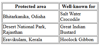
Hence, option (d) is correct.
Question 7:
With reference to coal-based thermal power plants in India, consider the following statements : (2023)
None of them uses seawater.
None of them is set up in water-stressed district.
None of them is privately owned.
How many of the above statements are correct? (a) Only one (b) Only two (c) All three (d) None
Solution:
Ans: (d)
Statement 1: "None of them uses seawater.": This statement is incorrect. Several coal-based thermal power plants in India, especially those located along the coastline, utilize seawater for cooling purposes. For instance, the Mundra Thermal Power Station in Gujarat uses seawater for its cooling systems.
Statement 2: "None of them is set up in water-stressed districts.": This statement is incorrect. A significant number of coal-based thermal power plants in India are situated in water-stressed regions. Approximately 48% of the existing coal-power fleet is located in areas facing water scarcity.
Statement 3: "None of them is privately owned.": This statement is incorrect. There are numerous privately owned coal-based thermal power plants in India. Companies such as Adani Power, Tata Power, and Reliance Power operate significant coal-based power stations. For example, the Mundra Thermal Power Station is operated by Adani Power, a private entity.
None of the statements are correct.
Correct Answer: (d) None
Question 8:
Consider the following pairs: (2022)
How many pairs given above are not correctly matched? (a) Only one pair (b) Only two pairs (c) Only three pairs (d) All four pairs
Solution:
Ans: (c)
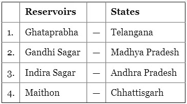
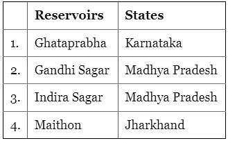
Ghataprabha has a hydroelectric and irrigational dam at Hidkal.
Hidkal Dam is located in Belagavi district in Karnataka. The dam was completed in 1977. To make it multipurpose project a reservoir was also constructed on the dam. Gandhi Sagar Dam on Chambal River (Madhya Pradesh) is one of the five water reservoirs of national importance.
Indira Sagar (Polavaram) project is located on river Godavari near Ramayyapet village of Polavaram Mandal of West Godavari district in Andhra Pradesh.
However, the Indira Sagar given in question lies in Madhya Pradesh as the Indira Sagar of Andhra Pradesh will include Polavaram in its name.
The Maithon Dam is located about 48 kms from the Coal City of Dhanbad (Jharkhand)
Hence, Option (c) is correct.
Question 9:
Gandikota canyon of South India was created by which one of the following rivers? (2022) (a) Cauvery (b) Manjira (c) Pennar (d) Tungabhadra
Solution:
Ans: (c) Gandikota is a Twi village in Cuddapah district of Andhra Pradesh surrounded by the Pennar River on the right, the village is popular for the spectacular valleys formed by the river running through the Erramala hills. The narrow valleys and steep rocky walls with streams running between them look very beautiful. Hence option (c) is correct.
Question 10:
Consider the following countries: (2022)
Azerbaijan
Kyrgyzstan
Tajikistan
Turkmenistan
Uzbekistan
Which of the above have borders with Afghanistan? (a) 1, 2 and 5 only (b) 1, 2, 3 and 4 only (c) 3, 4 and 5 only (d) 1, 2, 3, 4 and 5
Solution:
Ans: (c)
Afghanistan originally known as Ariana or Bactra and then as Khorasan (the land of the rising sun) is bounded by Iran and Turkmenistan to its west, Uzbekistan, Tajikistan and Kyrgyzstan to its north, Pakistan to its east and south, while the northeast portion of the Wakhan province of Afghanistan by China.
Afghanistan has borders with the following countries: China, Iran, Pakistan, Tajikistan, Turkmenistan and Uzbekistan.
Hence option (c) is correct.
Question 11:
With reference to India, consider the following statements? (2022)
Monazite is a source of rare earths.
Monazite contains thorium.
Monazite occurs naturally in the entire Indian coastal sands in India.
In India, Government bodies only can process or export monazite.
Which of the statements given above are correct? (a) 1, 2 and 3 only (b) 1, 2 and 4 only (c) 3 and 4 only (d) 1, 2, 3 and 4
Solution:
Ans: (b)
Monazite ore is found in India, Madagascar and in South-Africa. Monazite is an important ore of rare earths elements thorium, lanthanum, and cerium. The state-wise sources of monazite:
It is not found all along the Indian coast.
Private companies were not allowed to mine beach sand minerals until 1993. After liberalisation, private companies were initially allowed to mine garnet and sillimanite and permissions for other minerals followed.
An earlier amendment in 2016 barred private companies from mining beach sand that had monazite concentration of more than 0.75%.
Private firms are restricted from processing or exporting monazite. It remains a government monopoly, extracted under the purview of the Department of Atomic Energy.
Hence, option (b) is correct.
Question 12: With reference to the Indus river system, of the following four rivers, three of them
pour into one of them which joins the Indus direct. Among the following, which one
is such river that joins the Indus direct? [2021] (a) Chenab (b) Jhelum (c) Ravi (d) Sutlej
Solution:
Correct Answer is Option (d)
Starting at the pinnacle of the world with glaciers, the Indus River supplies the fl ora and fauna of temperate forests, plateaus, and dry rural areas. In conjunction with the rivers Chenab, Jhelum, Sutlej, Ravi, Beas, and two tributaries from Afghanistan and Khyber Pakhtunkhwa, the Indus creates the Sapta Sindhu (Seven Rivers) delta of Pakistan.
Chenab river moves into the lands of Punjab in the vicinity of Akhnur and is subsequently connected with the Jhelum. It creates the border between the Rechna and the Jech Doabs. The Chenab also meets the Ravi and the Sutlej in Pakistan.
The Ravi River runs as a portion of the boundary between India and Pakistan for a particular distance prior to moving into Pakistan and meeting the Chenab River.
The river moves into Pakistan in the vicinity of Sulemanki and is subsequently met by the Chenab.
Question 13: With reference to India, Didwana, Kuchaman, Sargol and Khatu are the names of [2021] (a) glaciers (b) mangrove areas (c) Ramsar sites (d) saline lakes
Solution:
Correct Answer is Option (d)
Didwana is a town in the Nagaur district of Rajasthan. It also has a famous Didwana salt-water lake of Rajasthan.
Kuchaman lake is a continental saline lake located around Kuchaman city, Nagaur District, Rajasthan.
Question 14:
Consider the following rivers: [2021]
Brahmani
Nagavali
Subarnarekha
Vamsadhara
Which of the above rise from the Eastern Ghats? (a) 1 and 2 (b) 2 and 4 (c) 3 and 4 (d) 1 and 3
Solution:
Correct Answer is Option (b)
Rivers originating on the Eastern Ghats include Baitarani River, Budhabalanga River, Rushikulya River, Vamsadhara River, Palar River, Nagavali River, and Champavathi River, etc.
The Baitarani River originates from Guptaganga hills in Keonjhar District of Orissa, about 2 km from Gonasika village, at an elevation of 900 m at latitude 21° 31' N and longitude 85° 33' E.
The Subernarekha River rises near Nagri village in the Ranchi District of Jharkhand at an elevation of 600 m. It flows for a length of 395 km before out falling into the Bay of Bengal.
Question 15: Consider the following statements : [2020-I] 1. Coal ash contains arsenic, lead and mercury. 2. Coal-fired power plants release sulphur dioxide and oxides of nitrogen into the environment. 3. High ash content is observed in Indian coal. Which of the statements given above is/are correct? (a) 1 only (b) 2 and 3 only (c) 3 only (d) 1, 2 and 3
Solution:
Correct Answer is Option (d)
Excessive burning of coal, wood, kerosene, petrol etc. release toxic gases such as SO2 (sulphur dioxide), NOx (oxide of nitrogen), CO (carbon monoxide) and hydrocarbons in the air. These gases are also emitted by industries, power plants, automobiles and aircrafts. Says NIOS Environment Book Page 33. So, #2 is correct.
Coal ash con tains contaminants like mercury, cadmium and arsenic. So, #1 is correct, So Answer (d).
Question 16: Consider the following minerals: [2020-I] 1. Bentonite 2. Chromite 3. Kyanite 4. Sillimanite In India, which of the above is/are officially designated as major minerals? (a) 1 and 2 only (b) 4 only (c) 1 and 3 only (d) 2, 3 and 4 only
Solution:
Correct Answer is Option (d) Chromite(#2) is a metallic mineral and metallic mineral are mostly in the major mineral category according to official sites of the ministry of mines 2,3 and 4 are listed as major minerals. So correct answer is (d)
Question 17: With reference to the management of minor minerals in India, consider the following statements: [2019-I] 1. Sand is a 'minor mineral' according to the prevailing law in the country. 2. State Governments have the power to grant mining leases of minor minerals, but the powers regarding the formation of rules related to the grant of minor minerals lie with the Centre Government. 3. State Governments have the power to frame rules to prevent illegal mining of minor minerals. Which of the statements given above is/are correct? (a) 1 and 3 only (b) 2 and 3 only (c) 3 only (d) 1, 2 and 3 only
Solution:
Correct Answer is Option (a)
By and large non-metallic non-energy minerals fall under 'Minor' category. So #1 is true.
Section 15 of MMDR Act, 1957 empowers state governments to frame rules for regulating the grant of quarry leases, mining leases or other mineral concessions in respect of minor minerals; accordingly all state governments and some union territories have framed their own rules in this regard. So, that means #2 is false, and #3 is correct. Accordingly, (a): 1 and 3 only.
Question 18: Consider the following statements: [2019-I] 1. As per the recent amendment to the India Forest Act, 1927, forest dwellers have the right to fell the bamboos grown in the forest areas. 2. As per the Scheduled Tribes and Other Traditional Forest Dwellers (Recognition of Forest Rights) Act, 2006, bamboo is a minor forest produce. 3. The Scheduled Tribes and other Traditional Forest Dwellers ( Recognition of Forest Rights) Act, 2006 allows ownership of minor forest produce to forest dwellers. Which of the following statements given above is/are correct? (a) 1 and 2 only (b) 2 and 3 only (c) 3 only (d) 1, 2 and 3
Solution:
Correct Answer is Option (b)
Indian Forest Act was amended to omit the word "bamboos" from the definition of tree, to exempt bamboos grown on non-forest area from the requirement of permit for felling or transit under the said Act, and would encourage bamboo plantation by farmers resulting in the enhancement of their income from agricultural fields. So, #1 is wrong.
In both b and c, statement #3 is common, so we've to accept it as true without verifying. Forest rights Act: Section 2(i) Minor forest produce includes bamboo, brushwood, honey, wax etc. So, #2 is right. Thus answer is b.
Question 19: Which is common to the places known as Aliyar, Isapur and Kangsabati? [2019-I] (a) Recently discovered uranium deposits (b) Tropical rain forests (c) Underground cave systems (d) Water reservoirs
Solution:
Correct Answer is Option (d) Aliyar (Tamiln adu), Isapur (Maharashtra) and Kangsabati (W.Bengal) are water Reservoirs.
Question 20: Consider the following states: [2019-I] 1. Chhattisgarh 2. Madhya Pradesh 3. Maharashtra 4. Odisha With reference to the states mentioned above, in terms of percentage of forest cover to the total area of State, which one of the following is the correct ascending order? (a) 2-3-1-4 (b) 2-3-4-1 (c) 3-2-4-1 (d) 3-2-1-4
Solution:
Correct Answer is Option (c) In terms of % forest cover: Madhya Pradesh: 25%, Odisha: 31%, Chhattisgarh: 42%, Maharashtra: 15%. Thus Maharashtra (3) is lowest and Chattisgarh (1) is highest forest cover in % term. So, pattern should be 3-2-4-1. There is only one such option c.
Question 21: Consider the following pairs : [2019-I] Famous place: River 1. Pandharpur: Chandrabhaga 2. Tiruchirapalli : Cauvery 3. Hampi: Malaprabha Which of the pair given above are correctly matched (a) 1 and 2 only (b) 2 and 3 only (c) 1 and 3 only (d) 1, 2 and 3
Solution:
Correct Answer is Option (a) The Chandrabhaga (Bhima) river flows through the Pandharpur. Tiruchirappalli, situated on the banks of the river Cauvery is the fourth largest city in Tamil Nadu. Hampi, the 14th century capital of one of the greatest empires of medieval India called the Vijayanagar Empire, lies in the state of Karnataka protected by the tempestuous river Tungabhadra. So #3 is wrong, by elimination answer is a.
Question 22: Which one of the following national parks lies completely in the Temperate alpine zone? [2019-I] (a) Manas national park (b) Namdapha national park (c) Neora valley national park (d) Valley of flower national park
Solution:
Correct Answer is Option (d) From the given options, Valley of flowers is completely in the temperate zone.
Question 23: Among the following cities, which one lies on a longitude closest to that of Delhi? [2018-I] (a) Bengaluru (b) Hyderabad (c) Nagpur (d) Pune
Solution:
Correct Answer is Option (a)
To determine which city lies on a longitude closest to that of Delhi, let's examine the approximate longitudes of the given cities:
Delhi: 77.23° E
Bengaluru: 77.59° E
Hyderabad: 78.47° E
Nagpur: 79.08° E
Pune: 73.85° E
Comparing these values, Bengaluru's longitude (77.59° E) is closest to Delhi's longitude (77.23° E).
Correct Answer: (a) Bengaluru
Question 24: Which one of the following is an artificial lake? [2018-I] (a) Kodaikanal (Tamil Nadu) (b) Kolleru (Andhra Pradesh) (c) Nainital (Uttarakhand) (d) Renuka (Himachal Pradesh)
Solution:
Correct Answer is Option (a) (A) Kodaikanal has 154-year-old, artificially-built lake. (B) Kolleru Lake Situated in Andhra Pradesh, it is the largest fresh water lake of Indi(a) It is located between the deltas of the Krishna and Godavari rivers in the Krishna and Godavari districts. The lake serves as a natural flood balancing reservoir for the two rivers, it's also a Ramsar convention site. (C) Nainital is situated in the foothills of the Himalayas, with the pear-shaped Naini lake at its centre. (D) Renuka Lake Situated in the Sirmaur district of Himachal Pradesh, this lake has been named after the goddess Renuk(a) A lion safari and a zoo are major attractions at Renuk(a) It is a site for the annual fair in the month of November.
Question 25: At one of the places in India, if you stand on the seashore and watch the sea, you will find that the seawater recedes from the shoreline a few kilometres and comes back to the shore, twice a day, and you can actually walk on the seafloor when the water recedes. This unique phenomenon is seen at [2017-I] (a) Bhavnagar (b) Bheemunipatnam (c) Chandipur (d) Nagapattinam
Solution:
Correct Answer is Option (c) Odisha state Government's tourism webpage says verbatim that Chandipur beach has a unique distinction on its own. Unlike other beaches, the sea water here recedes away from the shore line about five km twice a day, an unusual phenomenon, rarely found anywhere. Therefore answer is "C". Yes, some candidates have been circulating youtube clips of Bhavnagar beach with similar phenomenon, but when it comes to UPSC Answerkey, Government site wins over YouTube or Personal travel diary blogs.
Question 26: In which of the following regions of India are shale gas resources found? [2016-I] 1. Cambay Basin 2. Cauvery Basin 3. Krishna-Godavari Basin Select the correct answer using the code given below. (a) 1 and 2 only (b) 3 only (c) 2 and 3 only (d) 1, 2 and 3
Solution:
Correct Answer is Option (d) Research is under process for presence of shale gas in Cambay basin at Mehsana, Ahmedabad and Bharuch districts of Gujarat, Cauvery basin at Nagapattinam in Tamil Nadu and in KG Basin at East and West Godavari districts of Andhra Pradesh.
Question 27: Which of the following has/have been accorded 'Geographical Indication' status?[2015-I] 1.Banaras Brocades and Sarees 2.Rajasthani Daal-Bati-Churma 3.Tirupathi Laddu Select the correct answer using the code given below. (a)1 only (b) 2 and 3 only (c) 1 only 3 only (d) 1, 2 and 3
Solution:
Correct Answer is Option (c) Banaras Brocades and Sarees (Logo) has been accorded 'Geographical Indication' status. Rajasthani Daal-Bati-Churma is not in the list of Geographical Indications in Indus - Therefore option 'C' is correct.
Question 28: Which one of the following regions of India has a combination of mangrove forest, evergreen forest and deciduous forest? [2015-I] (a) North Coastal Andhra Pradesh (b) South-West Bengal (c) Southern Saurashtra (d) Andaman and Nicobar Islands
Solution:
Correct Answer is Option (d) Andaman and Nicobar Islands is rich in biodiversity. Different types of forests as Tropical Evergreen forests, Moist Deciduous forests, Mangrove forests, Littoral forests are found here.
Question 29: Consider the following rivers: [2015-I] 1. Vamsadhara 2. Indravati 3. Pranahita 4. Pennar Which of the above are tributaries of Godavari? (a) 1, 2 and 3 (b) 2, 3 and 4 (c) 1, 2 and4 (d) 2 and 3 only
Solution:
Correct Answer is Option (d) Major tributaries of the river include the Purna (South), Pravara, Indravati, Manjira River, Bindusara River, Sabari River, Wainganga, and Wardha River. Pranahita is the name given to the combined flow of the rivers Wardha and Wainganga.
Question 30: Which one of the following pairs of States of India indicates the easternmost and westernmost State? [2015-I] (a) Assam and Rajasthan (b) Arunachal Pradesh and Rajasthan (c) Assam and Gujarat (d) Arunachal Pradesh and Gujarat
Solution:
Correct Answer is Option (d) Arunachal Pradesh and Gujarat are the easternmost and westernmost States.
Question 31: Consider the following States [2015-I] 1. Arunachal Pradesh 2. Himachal Pradesh 3. Mizoram In which of the above States do 'Tropical Wet Evergreen Forests' occur? (a) 1 only (b) 2 and 3 only (c) 1 and 3 only (d) 1, 2 and 3
Solution:
Correct Answer is Option (c) Tropical Wet Evergreen Forests are found in Assam, Arunachal Pradesh, Meghalaya, Nagaland, Tripura, West Bengal and Andaman and Nicobar Island and on the eastern and western slopes of the Western Ghats in such states as Tamil Nadu, Karnataka, Kerala and Maharashtra.
Question 32: In a particular region in India, the local people train the roots of living trees into robust bridges across the streams. As time passes, these bridges become stronger. These unique 'living root bridges are found in [2015-I] (a) Meghalaya (b) Himachal Pradesh (c) Jharkhand (d) Tamil Nadu
Solution:
Correct Answer is Option (a) In the present-day Meghalaya state of northeast India is a form of tree shaping, which creates these suspension bridges, they are handmade from the aerial roots of living banyan fig trees.
Question 33: With reference to the 'Changpa' community of India, consider the following statements : [2014 - I] 1. They live mainly in the State of Uttarakhand. 2. They rear the Pashmina goats that yield fine wool. 3. They are kept in the category of Scheduled Tribes. Which of the statements given above is/are correct? (a) 1 only (b) 2 and 3 only (c) 3 only (d) 1, 2 and 3
Solution:
Correct Answer is Option (b) The Changpa are a semi-nomadic Tibetan ethnic group found mainly in Zanskar region of Jammu and Kashmir. They rear the Pashmina goats that yield a fine wool. They are kept inthe category of Scheduled Tribes.
Question 34: If you travel through the Himalayas, you are likely to see which of the following plants naturally growing there? [2014 - I] 1. Oak 2. Rhododendron 3. Sandalwood Select the correct answer using the code given below. (a) 1 and 2 only (b) 3 only (c) 1 and 3 only (d) 1, 2 and 3
Solution:
Correct Answer is Option (a) Oak and Rhododendron is found in Himalayan region while sandalwood is found in South India.
Question 35: Consider the following pairs: [2014 - I] Which of the above pairs are correctly matched? (a) 1 and 2 (b) 2 and 3 (c) 3 and 4 (d) 2 and 4
Solution:
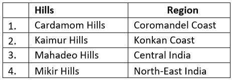
Correct Answer is Option (c) The Cardamom Hills are southern hills of India and part of the southern Western Ghats located in southeast Kerala and southwest Tamil Nadu. They are not on the coromandel coast. Kaimur Range is the eastern portion of the Vindhya Range extending from Madhya Pradesh to Bihar. They are not on the Konkan coast. The Mahadeo Hills are in Madhya Pradesh, the state of central India. Mikir hills are in Assam i.e. in North East India.
Question 36: Consider the following pairs: [2014 - I] Which of the above pairs is/ are correctly matched? (a) 1 only (b) 2 and 3 only (c) 1 and 3 only (d) 1, 2 and 3
Solution:
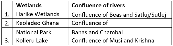
Correct Answer is Option (a) Harike Wetlands is at the Confluence of Beas and Satluj/ Sutlej. The Keoladeo National Park formerly known as the Bharatpur Bird Sanctuary in Bharatpur is at the confluence of two rivers, the Gambhir and Banganga. Kolleru Lake is one of the largest freshwater lakes in India located in the state of Andhra Pradesh. Kolleru is located between Krishna and Godavari delta.
Question 37: Consider the following rivers: [2014 - I] 1. Barak 2. Lohit 3. Subansiri Which of the above flows/flow through Arunachal Pradesh? (a) 1 only (b) 2 and 3 only (c) 1 and 3 only (d) 1, 2 and 3
Solution:
Correct Answer is Option (b) Rivers Lohit and Subansiri flow through Arunachal Pradesh. River Barak flows in south Assam and Manipur. River Lohit and subanseri flows through Arunachal Pradesh. Barak river flows in south Assam and Manipur.
Question 38: The seasonal reversal of winds is the typical characteristic of [2014 - I] (a) Equatorial climate (b) Mediterranean climate (c) Monsoon climate (d) All of the above climates
Solution:
Correct Answer is Option (c) Monsoon is the only climate which is having a reversal of wind between seasons.
Question 39: Consider the following pairs: [2014 - I] Which of the above pairs is/are correctly matched? (a) 1 and 2 only (b) 3 only (c) 1, 2 and 3 (d) None
Solution:
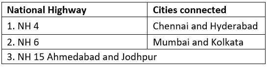
Correct Answer is Option (d) NH 4 is a major National Highway in Western and Southern India. It connects Mumbai with Chennai. NH 6, runs through Gujarat, Maharashtra, Chhattisgarh, Odisha, Jharkhand and West Bengal state in India. It connects Surat with Kolkata. NH 15 is a major National Highway in Western and Northwestern India. NH 15 connects Samakhiali in Gujarat with Pathankot in Punjab.
Question 40: Consider the following towns of India: [2014 - I] 1. Bhadrachalam 2. Chanderi 3. Kancheepuram 4. Karnal. Which of the above are famous for the production of traditional sarees/ fabric? (a) 1 and 2 only (b) 2 and 3 only (c) 1, 2 and 3 (d) 1,3 and 4.
Solution:
Correct Answer is Option (b) Chanderi in Madhyapradesh and Kancheepuram in Tamil Nadu are famous for Silk sarees.
Question 41: Consider the following statements: [2013 - I] 1. Natural gas occurs in the Gondwana beds. 2. Mica occurs in abundance in Kodarma. 3. Dharwar are famous for petroleum. Which of the statements given above is/are correct? (a) 1 and 2 (b) 2 only (c) 2 and 3 (d) None
Solution:
Correct Answer is Option (b) Dharwar rocks are non-fossilliferous rather they are metalliferous. They bear out gold, iron ore, manganese mica, cobalt, chromium, copper, tungsten, lead, nickel, precious stones and budding stones. Kodarma is a storehouse of mica and Gondwana beds that has coal and not natural gass.
Question 42: Which of the following statements regarding laterite soils of India are correct? [2013 - I] 1. They are generally red in colour. 2. They are rich in nitrogen and potash. 3. They are well-developed in Rajasthan and UP. 4. Tapioca and cashew nuts grow well on these soils. Select the correct answer using the codes given below. (a) 1, 2 and 3 (b) 2, 3 and 4 (c) 1 and 4 (d) 2 and 3 only
Solution:
Correct Answer is Option (c) Laterite soil is rusty red in colour due to iron oxide present in it. In the lateritic soil cashews and tapiocas can be grown.
Question 43: Which of the following is/are the characteristic/characteristics of Indian coal? [2013 - I] 1. High ash content 2. Low sulphur content 3. Low ash fusion temperature Select the correct answer using the codes given below. (a) 1 and 2 only (b) 2 only (c) 1 and 3 only (d) 1, 2 and 3
Solution:
Correct Answer is Option (a) Indian coal has high ash content and low calorific value. It has low sulphur and low phosphorous content but high ash fusion temperature.
Question 44: The Narmada river flows to the west, while most other large peninsular rivers flow to the east. Why? [2013 - I] 1. It occupies a linear rift valley. 2. It flows between the Vindhyas and the Satpuras. 3. The land slopes to the west from Central India. Select the correct answer using the codes given below. (a) 1 only (b) 2 and 3 (c) 1 and 3 (d) None
Solution:
Correct Answer is Option (a) Narmada is the largest west flowing river of peninsular India. Narmada flows westwards through a rift valley between the Vindhyan Range on the north and the Satpura Range on the south. The hilly regions are in the upper part of the basin, and lower-middle reaches are broad and fertile areas well suited for cultivation. The river slopes down near Jabalpur where it cascades (a small waterfall, especially one in a series) 15 m into a gorge to form the Dhuan Dhar (Cloud of Mist) fall.
Question 45: Consider the following pairs: [2013 - I] Which of the above pairs is/are correctly matched? (a) 1 and 2 (b) 3 only (c) 1 and 3 (d) None of these
Solution:
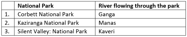
Correct Answer is Option (d) Through Corbett National Park Ramganga flows (not Ganga) which is a tributary of Ganges. Through Silent Valley National Park river Bhavani flows which is a tributary of Kaveri. Kaziranga and Manas are both national parks.
Question 46: Consider the following statements: [2012 - I] 1. The duration of the monsoon decreases from southern India to northern India. 2. The amount of annual rainfall in the northern plains of India decreases from east to west. Which of the statements given above is/are correct? (a) 1 only (b) 2 only (c) Both 1 and 2 (d) Neither 1 nor 2
Solution:
Correct Answer is Option (c) Both statements are correct. The amount of rainfall decreases from east to west owing to the progressive decrease in the humidity of the winds. The southern part of India, being near to the sea, gets rainfall early and for a longer duration than in the northern part.
Question 47: When you travel in the Himalayas, you will see the following: [2012 - I] 1. Deep gorges 2. U-turn river courses 3. Parallel mountain ranges 4. Steep gradients causing land-sliding Which of the above can be said to be the evidence for the Himalayas being young fold mountains? (a) 1 and 2 only (b) 1, 2 and 4 only (c) 3 and 4 only (d) 1, 2, 3 and 4
Solution:
Correct Answer is Option (d) When you travel in The Himalayas, you will see the Deep gorges, U-turn river courses, Parallel mountain ranges and Steep gradients causing land-sliding.
Question 48: With reference to the wetlands of India, consider the following statements: [2012 - I] 1. The country's total geographical area under the category of wetlands is recorded more in Gujarat as compared to other States. 2. In India, the total geographical area of coastal wetlands is larger than that of inland wetlands. Which of the statements given above is/are correct? (a) 1 only (b) 2 only (c) Both 1 and 2 (d) Neither 1 nor 2
Solution:
Correct Answer is Option (a) The countries total geographical area under the category of wetlands is more in Gujarat as compared to other states. India has 60% of inland wetland out of the total wetland.
Question 49: A particular State in India has the following characteristics: [2012 - I] 1. It is located on the same latitude which passes through northern Rajasthan. 2. It has over 80% of its area under forest cover. 3. Over 12% of forest cover constitutes Protected Area Network in this State. Which one among the following States has all the above characteristics? (a) Arunachal Pradesh (b) Assam (c) Himachal Pradesh (d) Uttarakhand
Solution:
Correct Answer is Option (a)
Question 50: A state in India has the following characteristics: 1. Its northern part is arid and semi-arid. 2. Its central part produces cotton. 3. Cultivation of cash crops is predominant over food crops. [2011 - I] Which one of the following states has all of the above characteristics? (a) Andhra Pradesh. (b) Gujarat. (c) Karnataka. (d) Tamil Nadu.
Solution:
Correct Answer is Option (b)
Gujarat has the following characteristics: 1. Its northern part is arid and semi-arid. 2. Its central parts produces cotton. 3. Cultivation of cash crops is predominant over food crops.
Question 51: The Brahmaputra, Irrawady and Mekong rivers originate in Tibet and flow through narrow and parallel mountain ranges in their upper reaches. Of these rivers, Brahmaputra makes a "U" turn in its course to flow into India. This "U" turn is due to[2011 -1] (a)Uplift of folded Himalayan series (b)Syntaxial bending of geologically young Himalayas (c)Geo-tectonic disturbance in the tertiary folded mountain chains (d)Both (a) and (b) above
Solution:
Correct Answer is Option (b) The Brahmaputra originates near Mt. Kailash and is known to take a U-turn near Mount Namcha Barwa. This U-turn is also known as Great Bend. The U-Turn is because of the 180° bend of the Himalayan structural trends.
Question 52: Which one of the following pairs of islands are separated from each other by the 'Ten Degree Channel'? [2014 - I] (a) Andaman and Nicobar (b) Nicobar and Sumatra (c) Maldives and Lakshadweep (d) Sumatra and Java
Solution:
Correct Answer is Option (a) The Ten Degree Channel is a channel that separates the Andaman Islands from the Nicobar Islands in the Bay of Bengal.
Question 53: The lower Gangetic plain is characterised by a humid climate with high temperatures throughout the year. Which one among the following pairs of crops is most suitable for this region? [2011 - I] (a) Paddy and Cotton (b) Wheat and Jute (c) Paddy and Jute (d) Wheat and Cotton
Solution:
Correct Answer is Option (c) The low and deltaic plains of the Ganges is characterised by swamps and Sundarbans. So, the people out there grow Paddy and Jute.
Question 54: Between India and East Asia, the navigation time and distance can be greatly reduced by which of the following? [2011 - I] 1. Deepening the Malacca straits between Malaysia and Indonesia. 2. Opening a new canal across the Kra Isthmus between the Gulf of Siam and the Andaman Sea. Which of the statements given above is/are correct? (a) 1 only (b) 2 only (c) Both 1 and 2 (d) Neither 1 nor 2
Solution:
Correct Answer is Option (b) Opening a new canal in Kra Isthums can reduce the navigation time and distance. The first statement in this question requires an explanation. Its worth note that the Malacca strait is the main shipping channel between the Indian Ocean and the Pacific Ocean and links India, China, Japan and South Korea. The issue of deepening of the Malacca strait is "linked" to its economic importance rather than "time of navigation and distance". The issue is that most of the ships can not pass through it and the size of the biggest ships which can enter through it is called Malaccamax. Now the deepening of the strait would certainly help in "Increasing the volume of the business" because ships of larger sizes can pass through it, there is no significance of distance and navigation.
Question 55: The approximate representation of land use classification in India is: [ 2010] (a) Net area sown 25%, forests 33%, other areas 42% (b) Net area sown 58%, forests 17%, other areas 25% (c) Net area sown 43%; forests 29%, other areas 28% (d) Net area sown 47%, forests 23%, other areas 30%
Solution:
Correct Answer is Option (d) The approximate representation of land use is classified as net area sown 46%, forests 23%, other areas 30%.
Question 56: The latitudes that pass through Sikkim also pass through: [2010] (a) Rajasthan (b) Punjab (c) Himachal Pradesh (d) Jammu and Kashmir
Solution:
Correct Answer is Option (a) The latitude that passes through Sikkim also passes through Rajasthan.
Question 57: If there were no Himalayan ranges, what would have been the most likely geographical impact on India? [2010] 1. Much of the country would experience the cold waves from Siberia. 2. Indo-Gangetic plain would be devoid of such extensive alluvial soils. 3. The pattern of the monsoon would be different from what it is at present. Which of the statements given above is/are correct? (a) 1 only (b) 1 and 3 only (c) 2 and 3 only (d) 1, 2 and 3
Solution:
Correct Answer is Option (d) All the statements given in the question are correct.
Question 58: Which one of the following is the appropriate reason to considering the Gondwana rocks as the most important of the rock systems of India? [2010] (a) More than 90% of limestone reserves of India are found in them (b) More than 90% of India's coal reserves are found in them (c) More than 90% of fertile black cotton soils are spread over them (d) None of the reasons given above is appropriate in this context
Solution:
Correct Answer is Option (b) More than 90% of India's coal reserves are found in the Gondwana rock system.
Question 59: When you travel to certain parts of India, you will notice red soil. What is the main reason for this colour? [2010] (a) Abundance of magnesium (b) Accumulated humus (c) Presence of ferric oxides (d) Abundance of phosphates
Solution:
Correct Answer is Option (c) Red soil in India is largely found in the Deccan plateau. Red soil is less clayey and sandier in nature and has a rich content of iron and a small amount of humus. Red soil is also known as yellow soil. The redness in the soil is due to Jerric oxide, which is 2nd largest soil found in India from south of Bundelkhand to North of Raj mahal hill.
Question 60: Rivers that pass through Himachal Pradesh are: [2010] (a) Beas and Chenab only (b) Beas and Ravi only (c) Chenab, Ravi and Sutlej only (d) Beas, Chenab, Ravi, Sutlej and Yamuna
Solution:
Correct Answer is Option (d) Rivers like Beas, Chenab, Ravi, Sutlej and Yamuna passes through Himachal Pradesh.
Question 61: With reference to, the river Luni, which one of the following statements is correct? [2010] (a) It flows into the Gulf of Khambhat (b) It flows into the Gulf of Kutch (c) It flows into Pakistan and merges with a tributary of Indus (d) It is lost in the marshy land of the Rann of Kutch
Solution:
Correct Answer is Option (d) Luni river originates from the Aravalli range and flows in the southwest direction through the hills and finally ends up in the marshy land of Rann of Kutch.
Question 62: In India, which type of forest among the following occupies the largest area? [2010] (a) Montane Wet Temperate Forest (b) Sub-tropical Dry Evergreen Forest (c) Tropical Moist Deciduous Forest (d) Tropical Wet Evergreen Forest
Solution:
Correct Answer is Option (c) In India tropical moist deciduous forest occupies the largest area. It includes the Deccan plateau, the northeastern region of the Deccan plateau and the lower slopes of the Himalayas and covers the part of Andhra Pradesh, Tamil Nadu, Orissa, Bihar, Chhatisgarh, Jharkhand, Karnataka and Kerala. In India, tropical moist deciduous forest covers 38% of the total forest area. It covers the region of Bihar, Uttar Pradesh, Odisha, Andhra Pradesh, Tamil Nadu, Jharkhand, Karnataka and Kerala.
Question 63: Consider the following pairs: [2010] Which of the pairs given above is/are correctly matched? (a) 1 only (b) 1 and 2 only (c) 2 only (d) 1, 2 and 3
Solution:
Correct Answer is Option (b) Hoolock is found in the Northeastern region of India. It covers 38% of the forest area. Hoolak Gibbon is found in the North-Eastern region of India.
Question 64: With reference to the mineral resources of India, consider the following pairs: [2010] Which of the pairs given above is/are correctly matched? (a) 1 and 2 only (b) 2 only (c) 1 and 3 only (d) 1, 2 and 3
Solution:
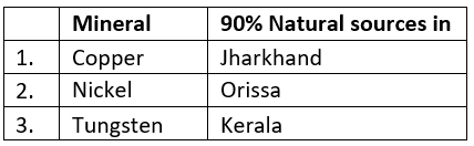
Correct Answer is Option (b) Orissa has 90% natural resources of Nickel.
FAQs on Geography of India - Solved Questions (2010- 2024)
1. Which Indian geographical features appear most frequently in UPSC previous year questions?
Ans. The Himalayas, Western Ghats, Deccan Plateau, and monsoon patterns dominate UPSC geography papers from 2010-2024. Coastal plains, river systems, and the Indo-Gangetic belt also feature regularly. Studying these recurring landforms and physiographic divisions through solved questions helps identify exam patterns and boosts answer accuracy significantly.
2. How do I identify which geographical regions have the highest weightage in UPSC exams based on past papers?
Ans. Analysing solved questions from 2010-2024 reveals that northern India's tectonic features, southern peninsula geology, and climatic zones carry consistent weightage. Eastern and Western Ghats, Thar Desert characteristics, and regional drainage systems appear frequently. Tracking topic repetition across years helps candidates prioritise studying geography of India strategically.
3. What types of map-based geographical questions appear in UPSC exams?
Ans. Map-based questions test candidates' knowledge of river basins, mountain ranges, plateaus, and state boundaries across Indian geography. Questions focus on locating mineral deposits, agricultural zones, forest regions, and coastal features. Solving previous year map questions strengthens spatial awareness and helps recognise question patterns that repeat in UPSC examinations.
4. Why do UPSC questions emphasize Indian climate zones and weather patterns so heavily?
Ans. Climate zones directly influence agriculture, population distribution, and resource management-critical for administration and policy-making. Southwest monsoon, retreating monsoon, and tropical/subtropical variations shape economic activity across regions. Understanding climate-geography links through solved examples clarifies why weather patterns remain a consistent exam focus for aspirants.
5. How should I use solved previous year questions to strengthen my geography of India foundation?
Ans. Review solved questions systematically to identify recurring concepts, common answer formats, and expected depth. Note how examiners phrase questions about physiography, climate, vegetation, and population patterns. Cross-reference answers with maps and flashcards available on EduRev to cement spatial understanding and improve retention for UPSC preparation effectively.
ppt, study material, Free, pdf , Extra Questions, practice quizzes, video lectures, Summary, Semester Notes, Geography of India - Solved Questions (2010- 2024), Geography of India - Solved Questions (2010- 2024), Sample Paper, mock tests for examination, past year papers, MCQs, Exam, Previous Year Questions with Solutions, Geography of India - Solved Questions (2010- 2024), Important questions, shortcuts and tricks, Viva Questions, Objective type Questions;