GS1 PYQ (Mains Answer Writing): Oceanography

Q1: How do the melting of the Arctic ice and glaciers of the Antarctic differently affect the weather patterns and human activities on the Earth? Explain. (UPSC GS1 Mains Paper)
Answer:
Arctic is an ocean covered by thin layers of perennial sea ice and surrounded by land while Antarctica is a continent covered by a very thick ice cap. Because of this fundamental difference in geography and ice type, the melting of ice in the two regions affects weather patterns and human activities in distinct but interconnected ways.
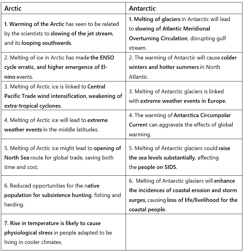
In summary, Arctic melting tends to drive strong regional climate feedbacks and open new human activity in the polar region, while Antarctic melting poses a larger long-term risk to global sea level. Both processes are interconnected and together increase risks to weather stability, ecosystems and human societies, making mitigation of greenhouse gas emissions and adaptation planning urgent priorities.
Q2: What are the forces that influence ocean currents? Describe their role in fishing industry of the world. (UPSC GS1 Mains Paper)
Answer:
Ocean currents are persistent, directed movements of seawater that behave like rivers within the ocean. They transport heat, salt and nutrients and are driven by several interacting forces.
These currents are shaped by two distinct groups of forces:
Primary forces:
Solar heating: Uneven solar heating produces temperature contrasts that create pressure and density differences, setting water in motion.
Wind: Persistent surface winds (for example, trade winds and westerlies) drag surface waters and initiate major surface currents.
Gravity: Gravity drives the flow of water from regions of higher sea surface height to lower, and it governs tidal movements.
Coriolis force: The Earth's rotation deflects moving water to the right in the Northern Hemisphere and to the left in the Southern Hemisphere, shaping the large-scale circulation and gyres.
Secondary forces:
Coastlines and bathymetry: Interaction with continental coasts, shallow shelves and underwater topography redirects and concentrates currents (for example, the Brazil Current hugging the South American coast).
Salinity and density differences: Variations in salinity cause denser water to sink and fresher water to remain near the surface, driving vertical and horizontal flows that feed larger circulation patterns.
Role of ocean currents in the world fishing industry:
Creation of rich fishing zones: Convergence and boundary regions where warm and cold currents meet tend to concentrate nutrients and organisms, forming highly productive fishing grounds (examples include parts of the North Pacific and regions off eastern Asia).
Upwelling and nutrient supply: Wind-driven upwelling brings cold, nutrient-rich deep water to the surface. This stimulates phytoplankton growth, which supports larger populations of zooplankton and commercially important fish - classic upwelling fisheries occur off the west coasts of South America, Africa and North America.
Transport of plankton and larvae: Currents carry plankton and fish larvae, influencing recruitment, species distribution and the connectivity of fish stocks between regions.
Quality and preservation: Fish from colder currents generally have slower spoilage rates and can have better shelf life and market value than those from warmer waters, affecting trade and processing industries.
Ecological balance and sustainability: Currents regulate oxygen levels, temperature and nutrient cycles that sustain marine food webs. Disruptions to currents can shift fish distributions and productivity, challenging fisheries management and requiring adaptation by fishing communities.
While currents naturally determine the location and productivity of many traditional fishing grounds, technological advances in fishing, aquaculture and monitoring are allowing the industry to adapt and to develop fisheries in other areas. Effective fisheries management must therefore combine knowledge of ocean circulation with ecological and socio-economic policies.
Q3: Why is India considered as a subcontinent? Elaborate your answer. (UPSC GS1 Mains Paper)
Answer:
India is regarded as a subcontinent because it represents a distinct physiographic and geological unit within South Asia with clear natural boundaries, a unique tectonic history and marked internal diversity. The key reasons are:
- Distinct landmass and plate tectonics: The Indian subcontinent largely sits on the Indian Plate, which separated from Gondwana and later collided with the Eurasian Plate about 55 million years ago. This tectonic history produced a recognisable and separate physical unit.
- Natural boundaries: The Himalaya, Karakoram and Hindu Kush mountain systems form a strong northern barrier. To the south, the Indian Ocean, Bay of Bengal and Arabian Sea enclose the landmass. These boundaries isolate the region geographically and climatically from the rest of Eurasia.
- Physiographic unity and variety: The subcontinent contains the Himalayas, Indo-Gangetic plains, peninsular plateau, coastal plains and island groups. Although internally diverse, these regions form a coherent geographic entity distinct from neighbouring areas.
- Climatic distinctiveness: Monsoon circulation, with its seasonal reversal of winds and heavy summer rains, gives the subcontinent a common climatic regime that shapes agriculture, settlement and economy across the region.
- Cultural and demographic scale: A very large population with shared historical interactions, migrations and exchanges has produced broad socio-cultural continuities - in languages, religions, agricultural practices and institutions - that make the region functionally like a small continent.
Together, these physical, climatic and human characteristics justify referring to India as a subcontinent: a distinct, large and internally varied region within South Asia whose natural limits and internal coherence set it apart from the rest of Eurasia.
FAQs on GS1 PYQ (Mains Answer Writing): Oceanography
| 1. What is oceanography? |  |
| 2. Why is oceanography important? | |
| 3. What are the different branches of oceanography? | |
| 4. How do oceanographers collect data? | |
| 5. What are some current challenges in oceanography? | |


