UPSC Previous Year Questions (Prelims): World Geography - 1

Q.1. Consider the following pairs: (2019-I)
Sea: Bordering country
- Adriatic Sea: Albania
- Black Sea: Croatia
- Caspian Sea: Kazakhstan
- Mediterranean Sea: Morocco
- Red Sea: Syria
Which of the pairs given above are correctly matched?
(a) 1, 2 and 4 only
(b) 1, 3 and 4 only
(c) 2 and 5 only
(d) 1, 2, 3, 4 and 5
Ans: (b)
Explanation: Pairs 1, 3 and 4 are correct. The Adriatic Sea borders Albania (1 correct). The Caspian Sea borders Kazakhstan (3 correct). The Mediterranean Sea borders Morocco (4 correct). Pair 2 is incorrect because Croatia lies on the Adriatic Sea, not on the Black Sea. Pair 5 is incorrect because Syria borders the Mediterranean Sea and does not open out to the Red Sea.
Q.2. Which of the following has/have shrunk immensely/dried up in the recent past due to human activities? (2018-I)
- Aral Sea
- Black Sea
- Lake Baikal
Select the correct answer using the code given below:
(a) 1 only
(b) 2 and 3
(c) 2 only
(d) 1 and 3
Ans: (a)
Explanation: The Aral Sea (1) has shrunk dramatically due to diversion of its inflowing rivers for irrigation; its area and volume have reduced to a small fraction of their former size. The Black Sea (2) has suffered ecological problems but has not "dried up." Lake Baikal (3) has faced environmental stress and biodiversity threats, but it has not shrunk to the extent described for the Aral Sea. Hence only 1 is correct.
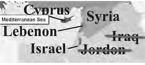
Q.3. The Mediterranean Sea is a border of which of the following countries? (2017-I)
- Jordan
- Iraq
- Lebanon
- Syria
Select the correct answer using the code given below:
(a) 1, 2, and 3 only
(b) 2 and 3 only
(c) 3 and 4 only
(d) 1, 3 and 4 only
Ans: (c)
Explanation: Lebanon (3) and Syria (4) both have coastlines on the Mediterranean Sea. Jordan (1) and Iraq (2) do not border the Mediterranean - Jordan has a short coastline on the Gulf of Aqaba (Red Sea) and Iraq is inland from the Mediterranean.
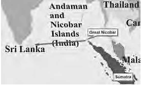
Q.4. Which of the following is geographically closest to Great Nicobar? (2017-I)
(a) Sumatra
(b) Borneo
(c) Java
(d) Sri Lanka
Ans: (a)
Explanation: Great Nicobar, the southernmost of the Andaman and Nicobar islands, lies in the Andaman Sea close to the northern end of Sumatra. Sumatra is therefore geographically closer to Great Nicobar than Borneo, Java or Sri Lanka.
Q.5. With reference to the 'Trans-Pacific Partnership', consider the following statements: (2016-I)
- It is an agreement among all the Pacific Rim countries except China and Russia.
- It is a strategic alliance for the purpose of maritime security only.
Which of the statements given above is/are correct?
(a) 1 only
(b) 2 only
(c) Both 1 and 2
(d) Neither 1 nor 2
Ans: (d)
Explanation: Both statements are incorrect. The Trans-Pacific Partnership (TPP) is a regional trade agreement negotiated among a group of Pacific-rim countries (originally 12 members) to reduce trade barriers and set common rules on trade, investment and related issues; it is not a pact of "all Pacific Rim countries except China and Russia." It is primarily an economic/trade agreement, not a strategic maritime-security alliance.Key objectives of the TPP include reducing tariffs, harmonising certain intellectual property rules, setting labour and environmental standards, and establishing investor-state dispute settlement mechanisms.
Q.6. Which one of the following countries of South-West Asia does not open out to the Mediterranean Sea? (2015-I)
(a) Syria
(b) Jordan
(c) Lebanon
(d) lsrael
Ans: (b)
Explanation: Jordan does not have a Mediterranean coastline. Its only sea access is a short coastline on the Gulf of Aqaba (part of the Red Sea). Syria, Lebanon and Israel all border the Mediterranean Sea.
Q.7. What is the correct sequence of occurrence of the following cities in South-East Asia as one proceeds from south to north? (2014 - I)
- Bangkok
- Hanoi
- Jakarta
- Singapore
Select the correct answer using the code given below.
(a) 4-2-1-3
(b) 3-2-4-1
(c) 3-4-1-2
(d) 4-3-2-1
Ans: (c)
Explanation: From south to north the order is Jakarta (3) in southern Indonesia, then Singapore (4) just north of the equator, followed by Bangkok (1) in central Thailand, and finally Hanoi (2) in northern Vietnam. Thus the sequence is 3-4-1-2.
Q.8. Consider the following pairs: (2014 - I)
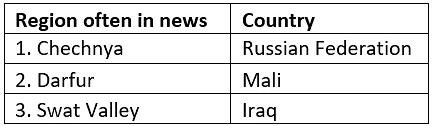
Which of the above pairs is/are correctly matched?
(a) 1 only
(b) 2 and 3 only
(c) 1 and 3 only
(d) 1, 2 and 3
Ans: (a)
Explanation: Pair 1 is correctly matched: the Chechen Republic is a federal subject (a republic) of the Russian Federation. The other place-names mentioned - Darfur and Swat - are known to be a region in western Sudan and a valley/district in Pakistan respectively; however, referring to the specific pairings shown in the image, only pair 1 is the correct match as indicated by the question.
Q.9. Turkey is located between (2014 - I)
(a) the Black Sea and the Caspian Sea
(b) the Black Sea and the Mediterranean Sea
(c) Gulf of Suez and the Mediterranean Sea
(d) Gulf of Aqaba and the Dead Sea
Ans: (b)
Explanation: Turkey lies between the Black Sea to its north and the Mediterranean Sea to its south. Its territory spans the Anatolian peninsula in Western Asia and a small part in southeastern Europe.
Q.10. Which one of the following can come across if one travels through the Strait of Malacca? (2010)
(a) Bali
(b) Brunei
(c) Java
(d) Singapore
Ans: (d)
Explanation: The Strait of Malacca lies between the Indonesian island of Sumatra and the Malay Peninsula. Singapore sits at the southern tip of the Malay Peninsula at the eastern entrance to the Strait of Malacca; hence Singapore can be encountered when transiting the strait.
Q.11. Which one of the following is the country's administrative capital new federal administrative centre of Malaysia? (2009)
(a) Kota Bharu
(b) Kuala Terengganu
(c) Putrajaya
(d) Taiping
Ans: (c)
Explanation: Putrajaya is the planned federal administrative centre of Malaysia where many government offices and ministries are located; it was developed to ease congestion in Kuala Lumpur.
Q.12. Which among the following has the world's largest reserves of Uranium? (2009)
(a) Australia
(b) Canada
(c) Russian Federation
(d) USA
Ans: (a)
Explanation: Australia holds the world's largest identified uranium reserves, estimated at about one quarter of the global total. Its known deposits are larger than those of the other listed countries.
Q.13. Cape Canaveral, the site from which space shuttles are launched is located on the coast of: (2009)
(a) Florida
(b) Virginia
(c) North Carolina
(d) South Carolina
Ans: (a)
Explanation: Cape Canaveral is located on the east coast of the U.S. state of Florida and hosts the Kennedy Space Center and other launch facilities.
Q.14. Match List I with List-II and select the correct answer using the code given below the lists: (2009)
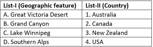
(a) A-1; B-2; C-4; D-3
(b) A-1; B-4; C-2; D-3
(c) A-3; B-2; C-4; D-1
(d) A-3; B-4; C-2; D-1
Ans: (b)
Explanation: The correct matching is:
- Great Victoria Desert - Australia
- Grand Canyon - USA
- Lake Winnipeg - Canada
- Southern Alps - New Zealand
Q.15. Which one among the following South Asian countries has the highest population density? (2009)
(a) India
(b) Nepal
(c) Pakistan
(d) Sri Lanka
Ans: (a)
Explanation: Among the listed countries, India has the highest overall population density (about 324 persons per sq. km as given here), higher than Nepal (≈102), Pakistan (≈146) and Sri Lanka (≈280).
Q.16. Consider the following countries: (2009)
- Australia
- Namibia
- Brazil
- Chile
Through which of the above does the Tropic of Capricorn pass?
(a) 1 only
(b) 2, 3 and 4
(c) 1, 2 and 3
(d) 1, 2, 3 and 4
Ans: (d)
Explanation: The Tropic of Capricorn crosses all four listed countries. It runs through Australia (1), Namibia (2), Brazil (3) and Chile (4) as it circles the Southern Hemisphere.
Q.17. Which two countries follow China and India in the decreasing order of their population? (2008)
(a) Brazil and the USA
(b) The USA and Indonesia
(c) Canada and Malaysia
(d) Russia and Nigeria
Ans: (b)
Explanation: In population ranking, after China and India come the United States of America (third) and Indonesia (fourth). Thus the correct pair is USA and Indonesia.Top four: China, India, USA, Indonesia (in decreasing order).
Q.18. Consider the following statements: (2008)
- Ajman is one of the seven emirates of the UAE.
- Ras al-Khaimah was the last Sheikhdom to join the UAE.
Which of the statements given above is/are correct?
(a) 1 only
(b) 2 only
(c) Both 1 and 2
(d) Neither 1 nor 2
Ans: (c)
Explanation: Both statements are correct. Ajman is one of the seven emirates that form the United Arab Emirates. Ras al-Khaimah was the seventh and last of the Trucial States to join the UAE, becoming a member in 1972.
Q.19. Which of the following countries share borders with Moldova? (2008)
- Ukraine
- Romania
- Belarus
Select the correct answer using the code given below:
(a) 1 and 2 only
(b) 2 and 3 only
(c) 1 and 3 only
(d) 1, 2 and 3
Ans: (a)
Explanation: Moldova is land-locked and shares borders with Ukraine (to the north, east and south) and Romania (to the west). Belarus does not border Moldova.
Q.20. Which one of the following straits is nearest to the International Date Line? (2008)
(a) Malacca Strait
(b) Bering Strait
(c) Strait of Florida
(d) Strait of Gibraltar
Ans: (b)
Explanation: The Bering Strait, between Alaska and eastern Russia, lies close to the 180° meridian and is therefore nearest to the International Date Line among the options listed.
Q.21. Which of the following cities is nearest to the equator? (2008)
(a) Colombo
(b) Jakarta
(c) Manila
(d) Singapore
Ans: (d)
Explanation: Singapore lies very close to the equator (about 1°17′ N, roughly 130-200 km north of the equator depending on the reference), making it the nearest among the listed cities.
Q.22. In which one of the following is Malta located? (2008)
(a) Baltic Sea
(b) the Mediterranean Sea
(c) the Black Sea
(d) the North Sea
Ans: (b)
Explanation: Malta is an island nation in the central Mediterranean Sea. It lies to the south of Italy and to the north of Libya.
Q.23. The largest coral reef in the world is found near the coast of which one of the following countries? (2007)
(a) Australia
(b) Cuba
(c) Ghana
(d) Philippines
Ans: (a)
Explanation: The largest coral reef system in the world is the Great Barrier Reef, which lies off the north-eastern coast of Australia. It extends for nearly 1,900 km and is protected as a marine park.
Q.24. Through which one of the following Straits, does a tunnel connect the United Kingdom and France? (2007)
(a) Davis Strait
(b) Denmark Strait
(c) Strait of Dover
(d) Strait of Gibraltar
Ans: (c)
Explanation: The Channel Tunnel (Chunnel) links the United Kingdom and France beneath the Strait of Dover, which is the narrowest part of the English Channel.
Q.25. Which one among the following rivers is the longest? (2007)
(a) Amazon
(b) Amur
(c) Congo
(d) Lena
Ans: (a)
Explanation: The Amazon River is among the longest rivers in the world and is often cited as the longest depending on measurement method; it also carries the greatest volume of water. Here, Amazon is the correct choice.
Q.26. Match List I with List II and select the correct answer using the code given below the lists: (2007)
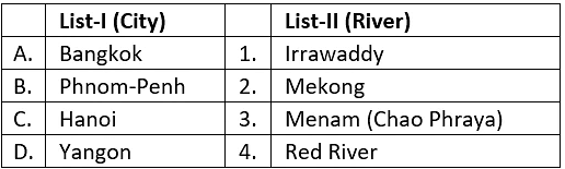
(a) A-3; B-2; C-4; D-1
(b) A-4; B-1; C-3; D-2
(c) A-3; B-1; C-4; D-2
(d) A-4; B-2; C-3; D-1
Ans: (a)
Explanation: The correct city-river matches are:
- Bangkok - Menam (Chao Phraya)
- Phnom Penh - Mekong
- Hanoi - Red River
- Yangon - Irrawaddy
Q.27. Which one of the following cities does not have the same clock time as that of the other three cities at any given instant? (2007)
(a) London (UK)
(b) Lisbon (Portugal)
(c) Accra (Ghana)
(d) Addis Ababa (Ethiopia)
Ans: (d)
Explanation: London, Lisbon and Accra are all close to the Greenwich Meridian (UTC±0) and share the same standard time (subject to daylight saving adjustments in Europe). Addis Ababa is well to the east (around longitude 38.7°E) and uses a time zone about three hours ahead of GMT, so its clock time differs from the other three at any given instant.
Q.28. Where is Copacabana Beach located? (2007)
(a) Buenos Aires
(b) the Hawaiian Islands
(c) Rio de Janeiro
(d) Valletta
Ans: (c)
Explanation: Copacabana Beach is a famous beachfront in Rio de Janeiro, Brazil.
Q.29. Other than India and China, which one of the following groups of countries border Myanmar? (2006)
(a) Bangladesh, Thailand and Vietnam
(b) Cambodia, Laos and Malaysia
(c) Thailand, Vietnam and Malaysia
(d) Thailand, Laos and Bangladesh
Ans: (d)
Explanation: Apart from India and China, Myanmar shares land borders with Bangladesh, Thailand and Laos. Vietnam and Malaysia do not border Myanmar.
Q.30. Which one of the following pairs is not correctly matched? (2006)
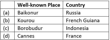
(a)a
(b)b
(c)c
(d) d
Ans: (a)
Explanation: Baikonur Cosmodrome - the world's first and one of the largest operational space launch facilities - is located in Kazakhstan, not in Russia. Therefore the pair that places Baikonur in Russia is not correctly matched.
Q.31. Through which, one of the following groups of countries does the Equator pass? (2006)
(a) Brazil, Zambia and Malaysia
(b) Colombia, Kenya and Indonesia
(c) Brazil, Sudan and Malaysia
(d) Venezuela, Ethiopia and Indonesia
Ans: (b)
Explanation: The Equator passes through Colombia in South America, Kenya in East Africa and Indonesia in Southeast Asia; these three are correctly listed in option (b).
Q.32. Consider the following statements: (2006)
- The length of a terrestrial mile is lesser than that of a nautical mile.
- Harmattan is a dusty land-wind of the East African Coast.
- Greece and Albania form a part of the Iberian Peninsula.
Which of the statement(s) given above is/are correct?
(a) 1, 2 and 3
(b) 2 and 3 only
(c) 3 only
(d) 1 only
Ans: (d)
Explanation: Statement 1 is correct: a terrestrial (statute) mile is about 1,609 metres while a nautical mile is about 1,852 metres, so the terrestrial mile is shorter. Statement 2 is incorrect: the Harmattan is a dry, dusty trade wind of West Africa blowing from the Sahara toward the Gulf of Guinea, not the East African coast. Statement 3 is incorrect: the Iberian Peninsula comprises primarily Spain and Portugal (and small states such as Andorra and Gibraltar); Greece and Albania are part of the Balkan Peninsula, not the Iberian Peninsula.
Q.33. Which one of the following countries is the leading producer of uranium? (2006)
(a) United States of America
(b) Canada
(c) Germany
(d) Zambia
Ans: (b)
Explanation: Among the options given in the question, Canada is the largest producer of uranium. (Note: global production figures change over time; in recent years Kazakhstan has emerged as the largest producer, but Canada remains one of the principal producers.)Leading uranium producers in the 2010s and 2016 included Kazakhstan, Canada, Australia, Niger and Namibia.
Q.34. Huangpu River flows through which one of the following cities? (2006)
(a) Beijing
(b) Ho Chi Minh City
(c) Shanghai
(d) Manila
Ans: (c)
Explanation: The Huangpu River flows through the city of Shanghai and provides much of the city's waterway system. It is a major river for Shanghai's urban area.
Q.35. Claims to the historical Macedonian territory have been a bone of contention between which of the following countries? (2006)
(a) Portugal and Spain
(b) Bulgaria and Greece
(c) Romania and Bulgaria
(d) Portugal and Greece
Ans: (b)
Explanation: Bulgaria and Greece have had disputes related to historical and cultural claims over the name and heritage of Macedonia. These disagreements centred on identity, historical legacy and related political issues.
Q.36. Bermuda Triangle extends up to which of the following places? (2006)
- Southern Florida
- Puerto Rico
- The Hawaiian Islands
Select the correct answer using the codes given below:
(a) 1, 2, and 3
(b) 1 and 2 only
(c) 2 and 3 only
(d) 1 and 3 only
Ans: (b)
Explanation: The Bermuda Triangle is usually defined as the triangular area formed by points at Bermuda, Puerto Rico and southern Florida. The Hawaiian Islands are far to the west in the central Pacific and are not part of the Bermuda Triangle.
Q.37. Which one of the following is the correct sequence of the given continents in the decreasing order of their percentage of Earth's land? (2005)
(a) North America-Africa-South America-Europe
(b) Africa-North America-South America-Europe
(c) North America-Africa-Europe-South America
(d) Africa-North America-Europe-South America
Ans: (b)
Explanation: In terms of land area the correct decreasing order among the listed continents is: Africa (largest of these), then North America, then South America, and then Europe. Thus option (b) is correct.
Q.38. Itaipu Dam built on the River Parana is one of the largest dams in the world. Which of the following two countries have this as a joint project? (2005)
(a) Brazil and Peru
(b) Paraguay and Ecuador
(c) Brazil and Paraguay
(d) Colombia and Paraguay
Ans: (c)
Explanation: The Itaipu Dam is a bi-national hydroelectric project shared between Brazil and Paraguay. It stands on the Paraná River at the border between the two countries.
Q.39. Consider the following statements: (2005)
- Great Britain comprises England, Wales, Scotland, and Northern Ireland.
- England covers less than 60% of the total area of the United Kingdom.
Which of the statements given above is/are correct?
(a) 1 only
(b) 2 only
(c) Both 1 and 2
(d) Neither 1 nor 2
Ans: (b)
Explanation: Statement 1 is incorrect: Great Britain refers to the island comprising England, Wales and Scotland; it does not include Northern Ireland. Statement 2 is correct: England's area is less than 60% of the total area of the United Kingdom (the UK comprises England, Scotland, Wales and Northern Ireland).
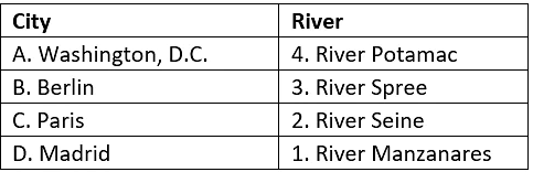
Q.40. Match List-I with List-II and select the correct answer using the codes given below the lists: (2005)
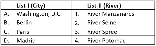
(a) A-2; B-3; C-4; D-1
(b) A-4; B-1; C-2; D-3
(c) A-2; B-1; C-4; D-3
(d) A-4; B-3; C-2; D-1
Ans: (d)
Explanation: The correct matching is given by option (d).
FAQs on UPSC Previous Year Questions (Prelims): World Geography - 1
| 1. What are some key concepts of world geography that are frequently asked in the UPSC exam? |  |
| 2. How can knowledge of world geography help in understanding global issues and challenges? | |
| 3. What are the main factors that influence the climate patterns across different regions of the world? | |
| 4. How do natural resources play a role in shaping the economic development and geopolitical dynamics of different countries? | |
| 5. What are some examples of major global challenges that have a direct or indirect impact on world geography? | |


