Map Based Work: Transport & Communication | Geography Class 12 - Humanities/Arts PDF Download
Q.1. Study the map given below carefully and answer the questions that follow.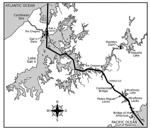
(i) Identify and name the canal shown in the map.
(ii) Write any four characteristics of this canal.
Ans:
(i) This map shows the Panama canal.
(ii) Four characteristics of this canal are:
- This connects the Atlantic ocean with the Pacific ocean.
- The canal cuts across the Isthmus of Panama and is a key conduit for international maritime trade.
- It is an artificial 48-mile waterway.
- It reduces the time for ships to travel between the Atlantic and Pacific ocean.
Q.2. Study the map and answer the questions that follow. (Delhi 2014)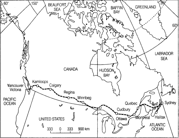 (i) Name the railway line shown on this map.
(ii) Name the terminal station of this railway along the Atlantic coast.
(iii) Why is this railway line known as the economic artery of the country through which it passes?
OR
(i) Name the Trans-continental railway shown on the map.
(ii) Name the terminal stations of this railway line.
(ii) Mention any two characteristics of this railway line.
Ans:
(i) Trans-Canadian railway line is shown on this map.
(ii) Halifax is the terminal station of this railway along the Atlantic coast.
(iii) It connects the Quebec-Montreal Industrial region with the wheat belt of the Prairie region and the Coniferous forest regions in the North. A loop line from Winnipeg to Thunder Bay connects this line with one of the important waterways. That’s why is it called economic artery of Canada.OR
(i) It is the Trans-Canadian railway.
(ii) Halifax and Vancouver are the terminal stations of this railway line
(iii) Two characteristics of this railway line are:
- It is 7050 km long rail line in Canada.
- It connects the industrial region to a wheat belt.
Q.3. Study the given map and answer the questions that follow. (All India 2009)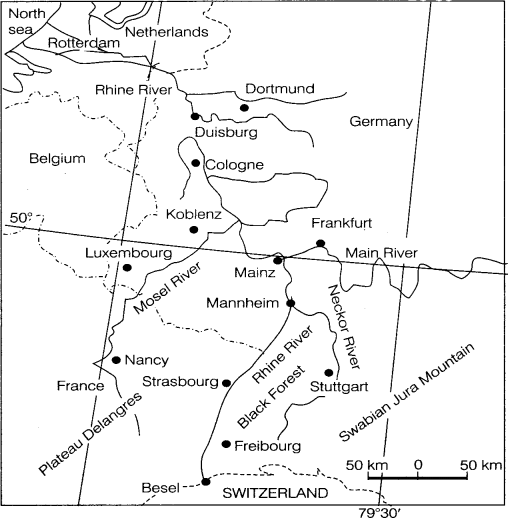 (i) Name the inland waterway shown in the given map.
(ii) How has this inland waterway been a boon in the development of the countries through which it passes? Explain.
Ans:
(i) The Rhine waterway is shown in the given map.
(ii) It is a boon in the development of the countries through which it passes because of the following reasons:
- It flows through Germany and the Netherlands.
- It is navigable up to 700 km.
- It flows through a rich coalfield and makes the white basin prosperous manufacturing area.
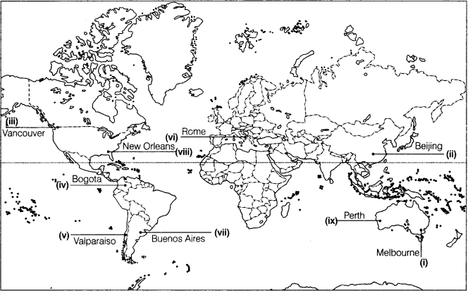
Q.4. Identify the following on the political map of the world.
(i) A major seaport. (All India 2016)
(ii) An international airport. (All Indio 2016)
(iii) A major seaport. (Delhi 2016,2013,2011,2008)
(iv) An international airport. (Delhi 2016)
(v) A major seaport. (All India 2015)
(vi) A major airport. (All Indio 2015, Delhi 2013)
(vii) An important airport. (Delhi 2015)
(viii) A major seaport. (Delhi 2015,2014.2012)
(ix) A major railway terminal. (All India 2015)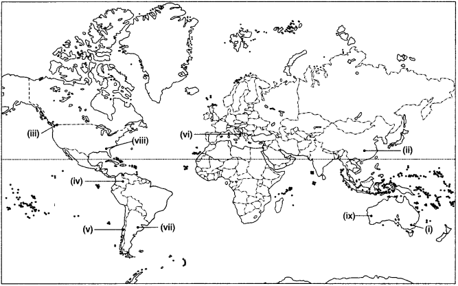
Ans:
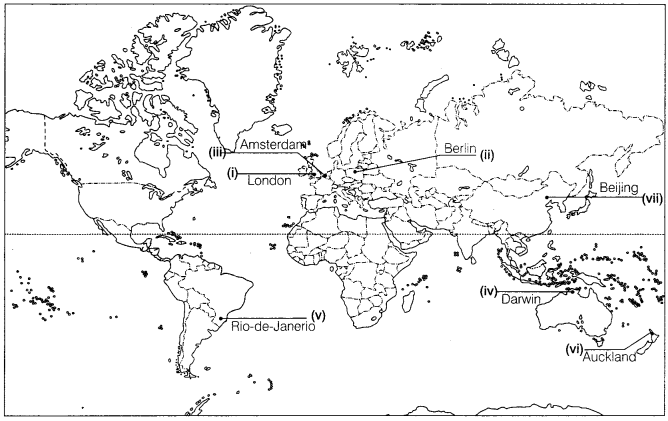
Q.5. Identify the following on the political map of the world,
(i) A major airport. (Delhi 2012)
(ii) A major seaport. (Delhi 2011)
(iii) A major seaport. (Delhi 2010)
(iv) A major airport. (Delhi 2010, All India 2008)
(v) The important seaport of Brazil, (AH India 2009)
OR
An important seaport. (All India 200a)
(vi) The important seaport of New Zealand. (Delhi 2009)
(vii) Major airport. (Delhi 2008)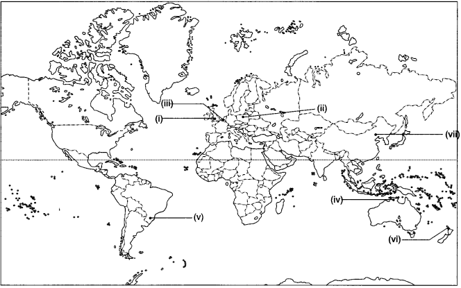
Ans:
Q.6. Study the map and answer the questions that follow. (All iIndio2014)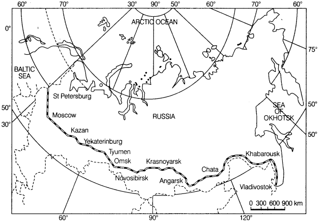 (i) Identify and name the railway line shown on the map.
(ii) Name the continents linked by this rail route.
(iii) Explain how this railway line is helpful for the promotion of trade in this region?
Ans:
(i) Trans-Siberian railway line is shown on the map.
(ii) It connects Asia and Europe.
(iii) This railway line runs across the Ural mountain and connects agro centres like Chita and Irkutsk. It also acts as a linkage between different manufacturing centres.
Q.7. Study the given map and answer the questions that follow, ail (India 2011)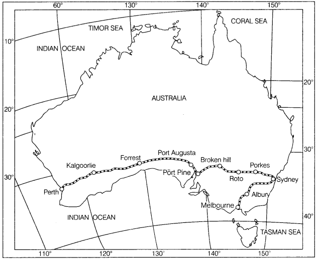 (i) Name the railway line shown in the given map.
(ii) Which are the two terminal stations of this railway line?
(iii) Name the ports located on the coast of Spencer Gulf through which this railway line passes, AH India 2009
Ans:
(i) Australian Trans-Continental railway line is shown in the given map.
(ii) Perth and Sydney are two terminal stations of Australian Trans-Continental railway line.
(iii) Port Augusta and Port Pine are two ports located on the coast of the Spencer Gulf through which this railway line passes.
Q.8. Study the map and answer the questions that follow. (All India 2008)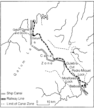 (i) Name the shipping canal shown in the map.
(ii) Name the oceans linked by this canal.
(iii) Name the country which has constructed this canal.
(iv) Why is this canal mostly used by the USA?
(v) Why does this canal have a lock system?
Ans:
(i) The canal shown in the map is the Panama Canal.
(ii) The oceans linked by this canal are the Atlantic ocean and the Pacific ocean.
(iii) The United States of America has constructed the Panama canal.
(iv) This canal is constructed by the US Government to shorten the distance between New York and San Francisco which is 12,000 km apart by sea.
(v) The canal is at a higher elevation from sea level and it is made across mountain ranges.
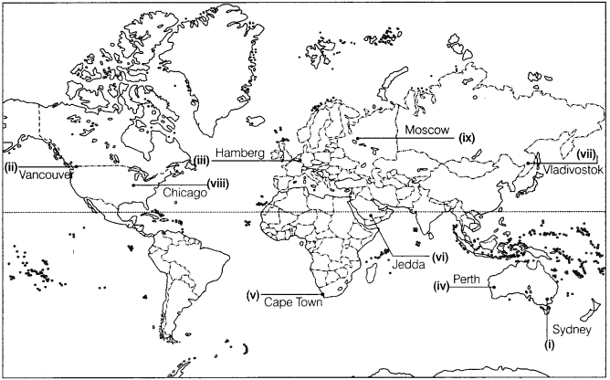
Q.9. Identify the following in the political map of the world.
(i) Railway terminal station. (Delhi 2015)
(ii) A terminal station of Trans-Canadian railway line, (AH India 2014)
(iii) An important seaport, (AH India 2014)
(iv) A terminal station of Australian Trans-continental railway. (Delhi 2014)
(v) A major seaport. (Delhi 2013. All India 2011.2010)
(vi) A major airport. (Delhi Board 2013)
(vii) Eastern Terminal station of Trans-Siberian railway. (All India 2012)
(viii) A major airport. (All Indio 2011)
(ix) A major airport. (All India 2010)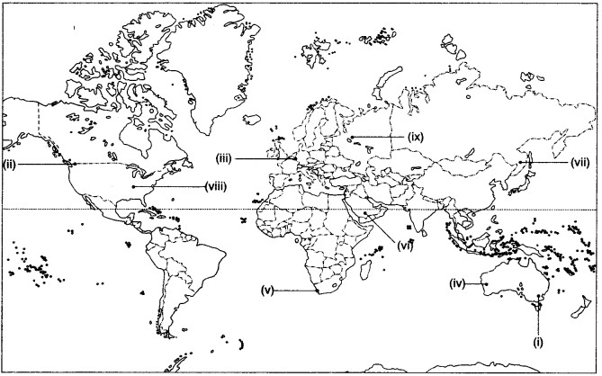
Ans:
|
50 videos|273 docs|37 tests
|
FAQs on Map Based Work: Transport & Communication - Geography Class 12 - Humanities/Arts
| 1. What is the significance of transport and communication in the development of societies? |  |
| 2. How have technological advancements impacted transport and communication? |  |
| 3. What are the environmental impacts of transport systems? |  |
| 4. How did historical transport networks shape the modern world? |  |
| 5. What role does government policy play in transport and communication development? |  |

