How to Solve Direction Questions? | Science Olympiad Class 6 PDF Download

What is Direction?
Direction is the information contained in the relative position of one point with respect to another point without the distance information. Directions may be either relative to some indicated reference or absolute according to some previously agreed upon frame of reference.
Cardinal directions
The four cardinal directions or cardinal points are:
- North
- East
- South
- West
Their initials commonly denote these directions: N, E, S, W. East and West are at right angles to North and South, with east being in the clockwise direction of rotation from north and west being directly opposite east.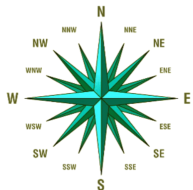
Representation of all 16 cardinal directions.
The intermediate directions of the four cardinal directions are: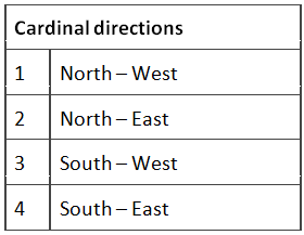 The intermediate directions are further classified as:
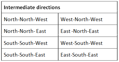
The Right and Left directional movement
The right and left movement of a person is always with reference to the body moving in the scenario. It is not with respect to the person who is solving the questions.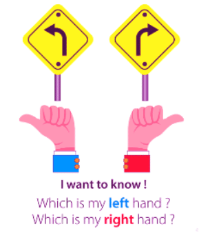
The directional reference point
Observe the five cities on the map shown below. The five cities are New Delhi, Mumbai, Bengaluru, Chennai, and Kolkata.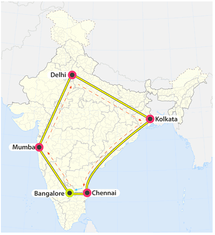 The directional reference point of five cities. The city Bengaluru is exactly below New Delhi, Hence, Bengaluru is in the South direction with respect to New Delhi whereas it is in the West direction with respect to Chennai. Mumbai is in North West direction with respect to Bengaluru whereas Bengaluru is in the South-East direction with respect to Mumbai. One should draw a cardinal direction at a reference city/place to find the direction of the other city.
The directions of sun rays and shadow
A boy is playing with a skipping rope in the playground and is facing North in the morning then, he observes that his shadow was towards his left as the Sun appeared in the East. The boy turned 180 degrees while playing, he is facing the South now. His own shadow will be towards his right as the Sun is in the east.
Sunrise/sunset and the shadow. He does this every day once in the morning and evening. He plays facing south and observed that his shadow was towards his left and then turns and faces North he observed that his shadow was towards his right. The direction of one’s’ shadow depends on the direction and time she/he is facing.
The table below summarises the relation of shadow with respect to the direction and time: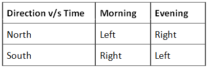
Correct map v/s Wrong map
This section involves the comparison of two maps between which one is definitely wrong. One has to find the correct direction in the wrong map by applying logical analysis.
Directions in Clocks
All the pirates and travellers during the 16th and 17th Centuries used the compass as a navigation device which helped them in the discovery of the land that was unknown to mankind. The clocks were lacking directional information as the main task of the clock was just to tell the time.
Adding the directions to the clock paved the way to the invention of many ideas in the future. The direction in which the number ‘12’ exists was considered as the North for the reference. And all the remaining directions were marked accordingly. Hence, the numbers ‘3’, ‘6’ and ‘9’ were considered to be at East, South, and West, respectively.
North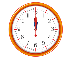
South
Pictorial representation of clocks with all the directions.
Directions in board games
In this section, the directional concepts are applied to popular board games like Chess and Carrom board or Snake and ladder to solve the questions.
Example: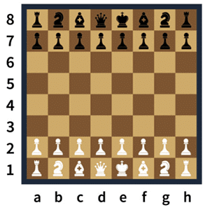 General placement of the chessboard.
A chess piece undergoes the following motion during the game. It starts from D-8, and reaches H-5, from there it reaches A-3, finally, it moves to the position H-8 and dies. In what direction the piece was when it died if the chess board is assumed to be placed in front of you?
Ans: The H-8 is the position where the chess piece died. If the chessboard is assumed to be placed in front of us, then the position H-8 will lie in between North and east. Hence, the answer is North-East.
Directions of Seating arrangement
This section involves the combination of directional logic with the seating arrangement.
Example: J, K, L, M, N, O, P and R are eight huts. L is 2 km east of K. J is 1 km north of K and Q is 2 km south of J. P is 1 km west of Q while M is 3 km east of P and O is 2 km north of P. R is situated right in the middle of K and L while N is just in the middle of Q and M.
Q: Distance between K and P is
Ans: Since K and P forms the diagonal of the right angle triangle KQP the distance between KP is 1.41 km. Hence, option C is the correct answer.
|
70 videos|150 docs|104 tests
|


How to Solve Direction Questions? | Science Olympiad Class 6
,Semester Notes
,ppt
,mock tests for examination
,study material
,Important questions
,Free
,Summary
,practice quizzes
,shortcuts and tricks
,Viva Questions
,Exam
,MCQs
,Extra Questions
,video lectures
,How to Solve Direction Questions? | Science Olympiad Class 6
,Previous Year Questions with Solutions
,Sample Paper
,How to Solve Direction Questions? | Science Olympiad Class 6
,past year papers
,Objective type Questions
;


How to Solve Direction Questions? Free PDF Download
Importance of How to Solve Direction Questions?
How to Solve Direction Questions? Notes
How to Solve Direction Questions? Class 6
Study How to Solve Direction Questions? on the App
|
© EduRev
|
Education Revolution
|


|


