Class 9 Geography Chapter 1 Practice Question Answers - Contemporary India - I
Multiple Choice Questions
Q1: The area of India is about-
(a) 3.82 million sq. kilometres
(b) 3.28 million sq. kilometres
(c) 3.16 million sq. kilometres
(d) 3.61 million sq. kilometres
Ans: (b)
The landmass of India has an area of 3.28 million square km.
Q2: India has a land boundary of about-
(a) 15,860 km.
(b) 15,250 km.
(c) 15,680 km.
(d) 15,200 km.
Ans: (d)
India has a land boundary of about 15,200 km.
Q3: How much times is India bigger than France?
(a) 6 times
(b) 16 times
(c) 4 times
(d) 9 times
Ans: (a) 6 times
India is 6 times bigger than France.
Q4: Standard Meridian of India passes through-
(a) Uttaranchal
(b) Punjab
(c) Mirzapur
(d) Alipur
Ans: (c) Mirzapur
The standard Meridian of India (82°30′ E) passes through Mirzapur in U.P.
Q5: India has …………. Union Territories-
(a) 28
(b) 7
(c) 6
(d) 14
Ans: (b) 7
India has 7 Union Territories and 28 states.
Q6: …………. ocean will have to be crossed by a ship going from Singapore to Mogadishu?
(a) Indian Ocean
(b) Passific Ocean
(c) Arctic Ocean
(d) Antarctic Ocean
Ans: (a)
Indian Ocean will have to be crossed by a ship going from Singapore to Mogadishu.
Q7: Which of these countries is located towards the east of India?
(a) Nepal
(b) Sri Lanka
(c) Bangladesh
(d) China
Ans: (c)
Bangladesh is located towards the east of India.
Q8: The longitudinal extent of India is …………. km.
(a) 3000
(b) 3200
(c) 3020
(d) 3060
Ans: (a)
The longitudinal extent of India is 3,000 km.
Q9: The Tropic of Cancer does not pass through-
(a) Rajasthan
(b) Chhattisgarh
(c) Orissa
(d) Tripura
Ans: (c)
The Tropic of Cancer divides the country into almost equal parts. Orissa lies above these states.
Q10: The capital of Mizoram is-
(a) Imphal
(b) Kohima
(c) Agartala
(d) Aizwal
Ans: (d)
Aizwal is the capital of Mizoram.
Fill in the blanks
Q11: India has ……………. states and ……………. Union Territories.
Ans: 28, 7
India is a country in South Asia that consists of 28 states and 7 Union Territories. These states and Union Territories each have their own governments, and the Union Territories are directly controlled by the federal government. This division allows for more effective governance and administration across the vast expanse of the country.
Q12: The ……………. extent influences the duration of day and night.
Ans: latitudinal
The term 'latitudinal extent' refers to the distance measured from the equator towards the poles. This extent influences the duration of day and night. The closer a place is to the poles, the longer the duration of daylight in summer and darkness in winter. Conversely, at the equator, day and night are almost equal in duration.
Q13: Suez Canal was opened in …………….
Ans: 1869
The Suez Canal is a man-made waterway in Egypt that connects the Mediterranean Sea to the Red Sea. It was opened in 1869 and was a significant development in global trade as it provided a shorter marine route between Europe and Asia. This helped in reducing the time, effort, and cost involved in the transportation of goods.
Q14: India lies entirely in the ……………. hemisphere.
Ans: northern
India is located entirely in the Northern Hemisphere. The term 'hemisphere' refers to a division of the earth into two halves. The equator, an imaginary line around the middle of the Earth, divides it into the Northern and Southern Hemispheres. Being in the Northern Hemisphere impacts India's climate and the timing of its seasons.
Q15: The east-west extent appears to be ……………. than the north-south extent.
Ans: smaller
The east-west extent of India appears to be smaller than the north-south extent. This refers to the geographical spread of the country from east to west (from Arunachal Pradesh in the east to Gujarat in the west) compared to the spread from north to south (from Jammu and Kashmir in the north to Kanyakumari in the south). This shape and orientation influence the country's climate, natural vegetation, and biodiversity.
True/False
Q16: The largest country of the world is China.
Ans: False
The statement is false because the largest country in the world, in terms of area, is Russia, not China. Russia has a total area of about 17.1 million square kilometers while China has about 9.6 million square kilometers. This makes Russia nearly twice as large as China.
Q17: About 8,000 km is reduced between Europe and India due to Suez Canal.
Ans: False
The statement is false because the Suez Canal does not reduce the distance between Europe and India by 8,000 km. The canal, located in Egypt, does shorten the maritime route between Europe and India, but the distance reduced is approximately 7,000 km, not 8,000 km.
Q18: Kanyakumari, in India is situated on three seas.
Ans: True
The statement is true because Kanyakumari, the southernmost point of mainland India, is indeed situated at the confluence of three water bodies - the Arabian Sea, the Bay of Bengal, and the Indian Ocean. Therefore it is often referred to as the 'Land's End'.
Q19: The sketch of India from West to East is 2,933 km.
Ans: True
The statement is true because the stretch of India from the westernmost point in Gujarat to the easternmost point in Arunachal Pradesh is approximately 2,933 km. This measurement is in line with the geographical statistics provided by the Survey of India.
Q20: The total length of coastline of India including Andaman and Nicobar and Lakshadweep Island is 7,516.6 km.
Ans: True
The statement is true because the total length of the coastline of India, including the island groups of Andaman and Nicobar and Lakshadweep, is indeed 7,516.6 km. This coastline is measured using a method known as the 'General Coastline Method', which includes the mainland coast as well as the coasts of all offshore islands.
Matching Questions
Q21: 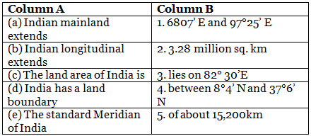
Ans:
Q22:
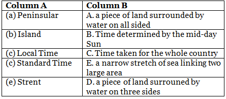
Ans:
|
53 videos|437 docs|80 tests
|

|
4.73/5 Rating |

|
Dec 23, 2024 Last updated |

|
Explore Courses for Class 9 exam
|
|
study material
,Free
,Class 9 Geography Chapter 1 Practice Question Answers - Contemporary India - I
,MCQs
,video lectures
,Class 9 Geography Chapter 1 Practice Question Answers - Contemporary India - I
,Viva Questions
,past year papers
,ppt
,Extra Questions
,Sample Paper
,mock tests for examination
,Important questions
,Exam
,practice quizzes
,Summary
,Objective type Questions
,Semester Notes
,Previous Year Questions with Solutions
,shortcuts and tricks
,Class 9 Geography Chapter 1 Practice Question Answers - Contemporary India - I
;


Practice Questions with Solutions: India – Size and Location Free PDF Download
Importance of Practice Questions with Solutions: India – Size and Location
Practice Questions with Solutions: India – Size and Location Notes
Practice Questions with Solutions: India – Size and Location Class 9
Study Practice Questions with Solutions: India – Size and Location on the App
|
© EduRev
|
Education Revolution
|


|


