Worksheet Solutions: The Southern Plateaus - 2

Q1: Fill in the blanks.
(i) River ______ divides the southern plateau into the Central Highlands and the Deccan Plateau.
Ans: Narmada
The Narmada River is one of the major rivers of central India and acts as a natural boundary, separating the Central Highlands to the north from the Deccan Plateau to the south.
(ii) The Eastern and Western ghats meet at the ______ Hills.
Ans: Nilgiri
The Nilgiri Hills form an important range in southern India and are the place where the Eastern and Western Ghats come together.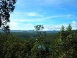
(iii) The Plateau which is not a part of the southern plateaus _______.
Ans: Tibetan Plateau
The Tibetan Plateau is not part of the southern plateaus. It is a large elevated region far to the north of India and is often called the "Roof of the World."
(iv) A river which does not flow through the southern plateaus ______.
Ans: Yamuna
The Yamuna flows mainly through northern India across the plains and does not pass through the southern plateaus.
(v) Black soil is good for growing ______.
Ans: Cotton
Black soil, also called regur soil, holds moisture well and is very fertile. For this reason, it is especially suitable for growing cotton and other similar crops.
(vi) Most of the people in the plateau region are ______.
Ans: Farmers
Agriculture is the main occupation in many plateau areas, so a large number of people living there earn their living by farming.
(vii) The southern plateaus are ______ in shape.
Ans: Triangular
On the map, the Deccan Plateau appears roughly triangular in shape, with the point directed towards the south of India.
(viii) The Deccan plateau is boarded by the ______ in the west.
Ans: Western Ghats
The Western Ghats form the western edge of the Deccan Plateau. They are a chain of hills that run along the western side of peninsular India.
(ix) The ______ and the Chota Nagpur Plateau together make the Central ______.
Ans: Malwa Plateau, Highlands
The Malwa Plateau and the Chota Nagpur Plateau together form the Central Highlands of India, which is an elevated region in the interior of the country.
(x) The rivers of the south are ______.
Ans: seasonal rivers
Many rivers in southern India depend mainly on the monsoon rains. They swell during the rainy season, and their flow reduces in the dry months, so they are called seasonal rivers.
(xi) The plateau region is rich in ______.
Ans: minerals
The plateau regions are rich in minerals such as iron ore, coal, bauxite and others. These minerals are important for industries and local economies.
Q2: Answer the following questions in short.
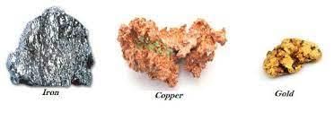
(i) What are the minerals found in the plateau region?
Ans: Iron ore, coal, manganese, gold, copper, and mica are the minerals found in the plateau region.
(ii) What are some of the valuable forest products that come from the plateau region?
Ans: Sandalwood, timber, plywood, bamboo, sal seeds, honey, rubber and spices are some valuable forest products obtained from the plateau region.
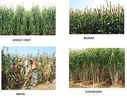
(iii) What type of crops are grown in the plateau region?
Ans: Rice, coconut, coffee, cotton and oranges are some of the crops grown in the plateau region.
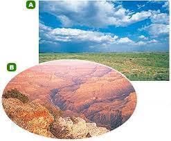
(iv) What is a plateau?
Ans: A plateau is a flat tableland that is higher than the land around it.
(v) What are the two parts of the southern plateaus?
Ans: The two parts of the southern plateaus are the Central Highlands and the Deccan Plateau.
Q3: Answer the following questions in detail.
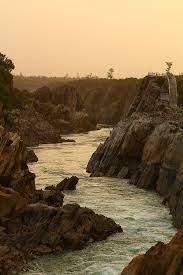
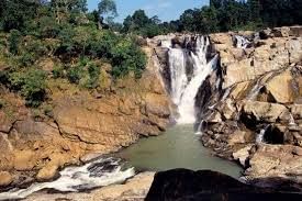
(i) Write a note on the important rivers of the southern plateaus.
Ans:
- The rivers of the south are mostly seasonal and depend on the monsoon rains.
- They fill up during the rainy season, and their flow reduces in the dry months.
- Mahanadi, Godavari, Krishna and Kaveri flow eastwards and drain into the Bay of Bengal.
- Narmada and Tapi (Tapi) flow westwards and empty into the Arabian Sea.
(ii) Describe the location and extent of the southern plateaus.
Ans:
- The southern plateaus stretch from the area south of the northern plains down to the southern tip of India.
- They are bordered on the west by the Western Ghats and on the east by the Eastern Ghats, which are hilly regions running along the coasts.
(iii) What is the importance of the plateau region?
Ans:
- The black soil of parts of the plateau is excellent for crops such as cotton, oilseeds and millets, and the region is rich in minerals used by industries.
- Thick forests on the plateaus provide valuable products like rubber, coffee, spices and timber, which support local livelihoods and trade.
Q4: Think and Answer.
How can you say if an area is a plateau or a plain?
Ans: A plateau is a high, flat area of land that stands above the surrounding land and is often rocky. A plain is low, flat and level land. If the land is raised and table-like, it is a plateau; if it is low and level, it is a plain.
FAQs on Worksheet Solutions: The Southern Plateaus - 2
| 1. What are the major features of the Southern Plateaus? |  |
| 2. How were the Southern Plateaus formed? | |
| 3. What is the climate like in the Southern Plateaus? | |
| 4. What is the significance of the Southern Plateaus? | |
| 5. Are the Southern Plateaus accessible to tourists? | |