Worksheet: Globes and Maps - 2

Q1: Fill in the Blanks
(i) A _______ is a spherical representation of the Earth.
(ii) The _______ is an imaginary line that divides the Earth into Northern and Southern Hemispheres.
(iii) A _______ is a flat representation of the Earth's surface.
(iv) Lines of _______ run east-west and measure the distance north or south of the Equator.
(v) The ______ is the line of longitude that divides the Earth into Eastern and Western Hemispheres.
(vi) A _______ on a map shows the cardinal directions - north, south, east, and west.
(vii) The ______ or ______ explains the symbols used on a map.
(viii) A _______ on a map helps to understand the distance between two places.
(ix) ________ show the boundaries and cities of countries.
(x) _________ display geographical features like mountains, rivers, and deserts.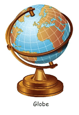
Q2: Multiple Choice Questions (MCQs)
(i) What is a globe?
(a) A flat representation of Earth
(b) A spherical representation of Earth
(c) A pyramid-shaped representation of Earth
(d) A cube-shaped representation of Earth
(ii) Which imaginary line divides the Earth into Northern and Southern Hemispheres?
(a) Prime Meridian
(b) Tropic of Cancer
(c) Equator
(d) Tropic of Capricorn
(iii) What does a compass rose on a map indicate?
(a) The legend/key
(b) Symbols used on the map
(c) Cardinal directions
(d) The scale of the map
(iv) What does a political map show?
(a) Geographical features
(b) Boundaries and cities of countries
(c) Climate zones
(d) Ocean currents
(v) Which line of longitude divides the Earth into Eastern and Western Hemispheres?
(a) Equator
(b) Tropic of Cancer
(c) International Date Line
(d) Prime Meridian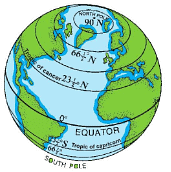
Q3: True or False:
(i) A map is a flat representation of the Earth's surface.
(ii) The Equator is a line of longitude.
(iii) A scale on a map helps determine the distance between places.
(iv) Physical maps show boundaries and cities of countries.
(v) The Prime Meridian runs from the North Pole to the South Pole.
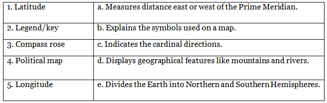
Q4: Match the Following:
Q5: Short Answer Questions:
(i) What is the purpose of a compass rose on a map?
(ii) Explain the difference between a political map and a physical map.
(iii) How do lines of latitude and longitude help in locating places on a map?
(iv) Why is a scale important on a map?
(v) Describe the role of the Equator in the geographic coordinate system.
The solutions of the worksheet "Globes and Maps - 2"
FAQs on Worksheet: Globes and Maps - 2
| 1. What's the difference between a globe and a map for Class 5 Social Studies? |  |
| 2. How do lines of latitude and longitude help you locate places on a map or globe? | |
| 3. Why do maps need a scale, compass, and legend to be useful? | |
| 4. What are the main types of maps and how do you know which one to use? | |
| 5. How does the shape of Earth affect the way maps are drawn and what problems does this create? | |


