Worksheet Solutions: Globes and Maps - 2

Q1: Fill in the Blanks:
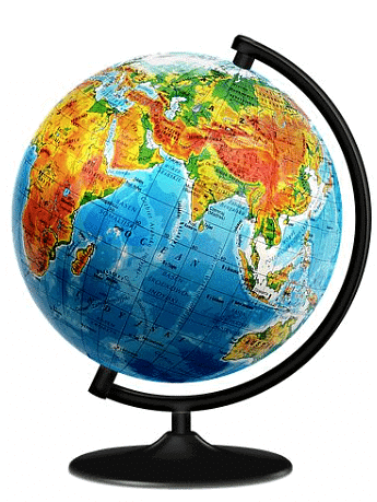
(i) A _______ is a spherical representation of the Earth.
Ans: globe
A globe is a spherical representation of the Earth. It shows the true shape of the Earth and the accurate positions of continents and oceans.
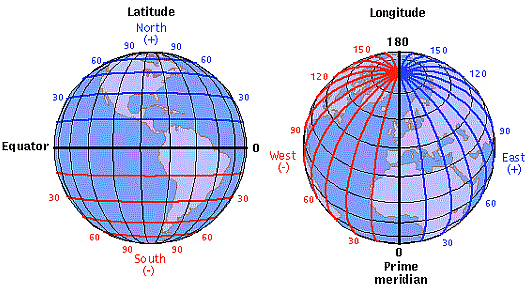
(ii) The _______ is an imaginary line that divides the Earth into Northern and Southern Hemispheres.
Ans: Equator
The Equator is an imaginary line at 0° latitude that divides the Earth into Northern and Southern Hemispheres. It is used as a reference for measuring latitude.
(iii) A _______ is a flat representation of the Earth's surface.
Ans: map
A map is a flat, two-dimensional representation of the Earth's surface. Maps simplify and show features so we can study and navigate places.
(iv) Lines of _______ run east-west and measure the distance north or south of the Equator.
Ans: latitude
Lines of latitude run east-west and are measured in degrees north or south of the Equator. They are parallel to each other and help locate places.
(v) The ______ is the line of longitude that divides the Earth into Eastern and Western Hemispheres.
Ans: Prime Meridian
The Prime Meridian is the line of longitude at 0° that divides the Earth into the Eastern and Western Hemispheres. It passes through Greenwich, London.
(vi) A _______ on a map shows the cardinal directions - north, south, east, and west.
Ans: compass rose
A compass rose on a map shows the four main directions and often the intermediate directions. It helps users to orient the map correctly.
(vii) The ______ or ______ explains the symbols used on a map.
Ans: legend, key
The legend or key lists and explains the symbols, colours and lines used on a map. It helps readers understand what each symbol means.
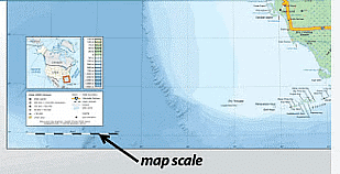
(viii) A _______ on a map helps to understand the distance between two places.
Ans: scale
A scale on a map shows the ratio between a distance on the map and the corresponding distance on the ground. It allows us to measure real distances.
(ix) ________ show the boundaries and cities of countries.
Ans: Political maps
Political maps show country and state boundaries, capitals and major cities. They are useful for understanding administrative divisions.
(x) _________ display geographical features like mountains, rivers, and deserts.
Ans: Physical maps
Physical maps display natural features such as mountains, rivers, plains and deserts. They help us study the Earth's physical landscape.
Q2: Multiple Choice Questions (MCQs)
(i) What is a globe?
(a) A flat representation of Earth
(b) A spherical representation of Earth
(c) A pyramid-shaped representation of Earth
(d) A cube-shaped representation of Earth
Ans: (b)
Explanation: A globe is a three-dimensional model of the Earth, and so it represents the planet's shape and the positions of lands and oceans accurately. Unlike a flat map, a globe shows correct proportions and directions without major distortion.
(ii) Which imaginary line divides the Earth into Northern and Southern Hemispheres?
(a) Prime Meridian
(b) Tropic of Cancer
(c) Equator
(d) Tropic of Capricorn
Ans: (c)
Explanation: The Equator is an imaginary circle at 0° latitude that divides the Earth into the Northern and Southern Hemispheres. It serves as the starting point for measuring latitude and is equidistant from the poles.
(iii) What does a compass rose on a map indicate?
(a) The legend/key
(b) Symbols used on the map
(c) Cardinal directions
(d) The scale of the map
Ans: (c)
Explanation: A compass rose shows the main directions-north, south, east and west- on a map. This helps map users to orient the map correctly and find directions between places.
(iv) What does a political map show?
(a) Geographical features
(b) Boundaries and cities of countries
(c) Climate zones
(d) Ocean currents
Ans: (b)
Explanation: Political maps emphasise human-made boundaries such as countries, states and cities. They help identify administrative regions and important settlements rather than natural features.
(v) Which line of longitude divides the Earth into Eastern and Western Hemispheres?
(a) Equator
(b) Tropic of Cancer
(c) International Date Line
(d) Prime Meridian
Ans: (d)
Explanation: The Prime Meridian is the 0° line of longitude that divides the Earth into Eastern and Western Hemispheres. It is the reference from which east and west longitudes are measured.
Q3: True or False:
(i) A map is a flat representation of the Earth's surface.
Ans: True
Explanation: A map is a two-dimensional or flat representation of the Earth's surface. It allows us to view and study different features and locations from above.
(ii) The Equator is a line of longitude.
Ans: False
Explanation: The Equator is a line of latitude at 0° that runs east-west. Lines of longitude run from the North Pole to the South Pole and measure east-west position.
(iii) A scale on a map helps determine the distance between places.
Ans: True
Explanation: A map scale gives the ratio between a map distance and the actual ground distance, so it allows map users to estimate real distances between locations.
(iv) Physical maps show boundaries and cities of countries.
Ans: False
Explanation: Physical maps focus on natural features such as mountains, rivers and plains. Political maps, not physical maps, show human-made boundaries and cities.
(v) The Prime Meridian runs from the North Pole to the South Pole.
Ans: True
Explanation: The Prime Meridian is a line of longitude that extends from the North Pole to the South Pole and is used as the zero reference for measuring longitude.
Q4: Match the Following:
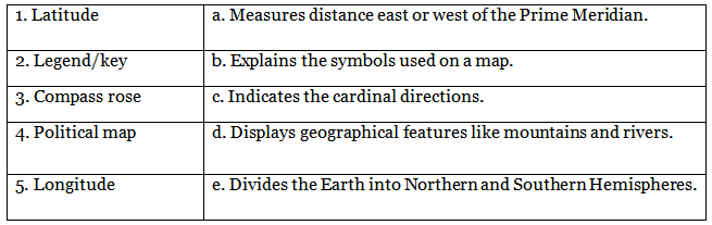
Ans: 1 - e, 2 - d, 3 - a, 4 - b, 5 - c
Q5: Short Answer Questions:
(i) What is the purpose of a compass rose on a map?
Ans: The compass rose indicates the cardinal directions-north, south, east and west- so readers can orient the map and find directions accurately.
(ii) Explain the difference between a political map and a physical map.
Ans: A political map shows human-made divisions such as countries, states and cities and their boundaries. A physical map shows natural features such as mountains, rivers and deserts and highlights the landscape's shape.
(iii) How do lines of latitude and longitude help in locating places on a map?
Ans: Lines of latitude (east-west) and longitude (north-south) form a grid on the Earth. Their intersecting values give coordinates (latitude and longitude) that pinpoint any place on the globe or a map.
(iv) Why is a scale important on a map?
Ans: A map scale shows the relation between a distance on the map and the true distance on the ground. It allows users to measure or calculate how far places are from one another in real terms.
(v) Describe the role of the Equator in the geographic coordinate system.
Ans: The Equator is the 0° latitude line that circles the Earth horizontally and divides it into the Northern and Southern Hemispheres. It is the starting point for measuring latitude and influences climate patterns near the tropics.
FAQs on Worksheet Solutions: Globes and Maps - 2
| 1. What is the main purpose of using globes and maps? |  |
| 2. How are globes different from maps? | |
| 3. Can globes and maps be used interchangeably for navigation purposes? | |
| 4. What are some common features found on both globes and maps? | |
| 5. How do globes and maps help in understanding the concept of scale? | |


