Important Questions: Distribution of Oceans & Continents

Very Short Answer Type Questions
Q1: Who first propounded the theory of continental drift?
Ans: Alfred Wegener propounded the theory of continental drift in 1912. He suggested that the continents were once joined as a single supercontinent called Pangaea and later drifted apart.
Q2: How did the Himalayas rise?
Ans: The Himalayas rose when the northward-moving Indian Plate collided with the Eurasian Plate. The collision caused intense folding, faulting and uplift of crustal rocks along the suture zone, producing the Himalayan mountain chain.
Q3: Name the continents into which the supercontinent, Pangaea, got split.
Ans: They split into two large landmasses called Laurasia (northern) and Gondwanaland (southern).
Q4: What are hot spots?
Ans: The mid-oceanic ridges are characterised by a central rift system at the crest. This is the zone of intense volcanic activity where constant eruptions bring huge amounts of lava to the surface.
Q5: The collision between which two plates gave rise to the Himalayas?
Ans: The collision between the Indian Plate and the Eurasian Plate gave rise to the Himalayas.
Q6: What is Palaeomagnetism?
Ans: Palaeomagnetism is studied through the magnetic properties of rocks from oceanic regions. The rocks equidistant on either side of the crest of mid-oceanic ridges show remarkable similarities in magnetic properties. Rocks closer to the ridges have normal polarity and are the youngest while the strips of normal and reverse magnetic field parallel to the ridges help determine past positions of continents.
Q7: In which parts Pangaea was split?
Ans: Pangaea was split into the northern landmass called Laurasia and the southern landmass called Gondwanaland.
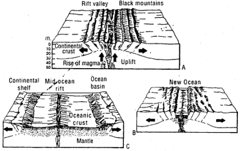
Q8: What is meant by sea-floor spreading?
Ans: Sea-floor spreading is the process by which new oceanic crust is formed at mid-ocean ridges where molten material rises, solidifies and pushes existing sea floor away from the ridge, causing the ocean basin to widen.
Short Answer Type Question
Q9: Why do geographers focus their attention on plate boundaries?
Ans: Geographers focus on plate boundaries because most major tectonic processes occur there. Plate boundaries are the sites of earthquakes, volcanism, mountain building and the formation of ocean trenches and ridges. Studying these zones helps explain the Earth's changing surface and associated natural hazards.
Q10: Discuss the causes of plate movement.
Ans: Plate movement is driven by convectional currents operating in the mantle portion. These currents are generated due to radioactive elements causing thermal differences in the mantle. The heated material rises to the surface, spreads and begins to cool, and then sinks back into deeper depths. This cycle is repeated over and over to generate a convection cell or convective flow. Heat within the earth comes from radioactive decay and residual heat.
Q11: What is subduction?
Ans: Subduction is the process in which one tectonic plate (usually an oceanic plate) descends beneath another plate into the mantle. Subduction zones produce deep ocean trenches, active volcanism, and a range of earthquakes from shallow to deep focus.
Q12: Account for the formation of the Himalayas according to the theory of plate tectonics in three points.
Ans:
- The northward movement of the Indian Plate led it to collide with the Eurasian Plate about 50 million years ago.
- Continuous compression at the collision zone caused intense folding, thrusting and uplift of sedimentary and crustal rocks, forming the Himalayan mountain belt; the main suture lies roughly along the Indus-Brahmaputra region.
- Convergence between the plates continues today, causing ongoing uplift, crustal deformation and frequent seismic activity in the Himalayan region.
Q13: Describe the driving force for the movement of plates.
Ans: The primary driving force is convectional currents in the mantle. The mobile rock beneath the rigid plates is believed to be moving in a circular manner. The heated material rises to the surface, spreads and begins to cool, and then sinks back into deeper depths. This cycle generates a convection cell or convective flow. The slow movement of hot, softened mantle that lies below the rigid plates is the driving force behind the plate movement.
Long Answer Type Questions
Q14: Discuss the Continental Drift Theory.
Ans: Continental Drift Theory was proposed by Alfred Wegener in 1912. He suggested that the present continents were once joined to form a single supercontinent called Pangaea, which later broke up and its pieces drifted to their present positions. Wegener supported his idea with several lines of evidence:
- The fit of continental margins, for example how the east coast of South America and the west coast of Africa appear to match.
- Matching rock types and geological structures (fold belts and mountain ranges) across now-separated continents.
- Similar fossil assemblages (for example identical plant and animal fossils) found on widely separated continents, indicating former connection.
- Palaeoclimatic evidence such as glacial deposits and coal beds in regions that today have different climates.
- Palaeomagnetic data showing movement of continents relative to Earth's magnetic poles.
Although Wegener could not identify the exact mechanism for drift, his ideas laid the foundation for the modern theory of plate tectonics which explains the forces and processes involved.
There are several pieces of evidence that suggest the existence of Pangaea. This evidence is available in the form of geological correlations, palaeoclimatic indicators and palaeomagnetism.
Q15: Explain the plate tectonic theory and its mechanism.
Ans: Plate tectonic theory states that the earth's lithosphere is divided into seven major and some minor plates. A tectonic plate is a massive, irregularly-shaped slab of solid rock, generally composed of both continental and oceanic lithosphere. Plates move horizontally over the asthenosphere as rigid units. The lithosphere includes the crust and top mantle with its thickness range varying between 5 and 100 km in oceanic parts and about 200 km in the continental areas. The mechanism involves convectional currents in the mantle. The heated material rises, spreads, cools and sinks, generating convection cells. There are three types of plate boundaries: divergent boundaries where new crust is generated as the plates pull away from each other, convergent boundaries where the crust is destroyed as one plate dives under another, and transform boundaries where the crust is neither produced nor destroyed as the plates slide horizontally past each other.
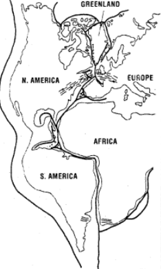
Q16: What do you mean by 'jig-saw-fit'? Describe the similarities found on the east and west coasts of the Atlantic ocean. What do they suggest
Ans: The term 'jig-saw-fit' refers to the way continental coastlines appear to fit together like pieces of a jigsaw puzzle, suggesting they were once joined. Similarities between the east coast of South America and the west coast of Africa and Europe include:
- Coastline fit: Features such as the Gulf of Guinea and the bulge of Brazil match closely; parts of Western Europe and the eastern coast of North America (including Greenland) also show complementary outlines.
- Geological similarities: Rock types and geological structures on opposite coasts correspond in age and character.
- Fossil evidence: Identical fossil plants and animals (for example Mesosaurus and Glossopteris) are found on both sides of the Atlantic.
- Palaeoclimatic evidence: Glacial deposits and other climate indicators occur in matching sequences across separated continents.
These similarities support the idea that these continents were once joined and later drifted apart.
Q17: Describe the main features of the Indian plate.
Ans: The Indian plate includes Peninsular India and the Australian continental portions. The subduction zone along the Himalayas forms the northern plate boundary in the form of continent-continent convergence. In the east, it extends through Rakinyoma Mountains of Myanmar towards the island arc along the Java Trench. The eastern margin is a spreading site lying to the east of Australia in the form of an oceanic ridge in SW Pacific. The Western margin follows Kirthar Mountain of Pakistan. It further extends along the Makrana coast and joins the spreading site from the Red Sea rift southeastward along the Chagos Archipelago. The boundary between India and the Antarctic plate is also marked by oceanic ridge running in roughly W-E direction and merging into the spreading site, a little south of New Zealand. India collided with Asia about 40-50 million years ago causing rapid uplift of the Himalayas. A major event that occurred was the outpouring of lava and formation of the Deccan Traps.
Q18: Describe sea-floor spreading in brief.
Ans: Sea-floor spreading is the process by which new oceanic crust forms at mid-ocean ridges and moves away from the ridge axis. Magma rises at the ridge, solidifies to create new basaltic crust, and the sea floor on either side moves apart. Key points:
- New crust is youngest at the ridge crest and becomes progressively older away from the ridge.
- The process widens ocean basins; for example, the Atlantic Ocean has been widening as the Mid-Atlantic Ridge pushes the plates apart.
- Sea-floor spreading explains the matching magnetic stripes on either side of ridges, produced by reversals of Earth's magnetic field recorded in newly formed crust.
Q19: Name the major plates of the earth. Which plate is composed of the oceanic plate?
Ans: The earth's lithosphere is divided into seven major plates. The major plates are: I Antarctica and the surrounding oceanic plate, II North American plate, III South American plate, IV Pacific plate, V India-Australia-New Zealand plate, VI Africa with the eastern Atlantic floor plate, VII Eurasia and the adjacent oceanic plate. The Pacific plate is largely an oceanic plate.
Q20: What is polar wandering?
Ans: Polar-fleeing force relates to the rotation of the earth. The polar-fleeing force relates to the rotation of the earth and was suggested by Wegener as one of the forces responsible for the drifting of the continents along with tidal force.
FAQs on Important Questions: Distribution of Oceans & Continents
| 1. What are the major oceans of the world? |  |
| 2. How are continents distributed across the globe? | |
| 3. What is the significance of ocean currents? | |
| 4. How do tectonic plates affect the distribution of oceans and continents? | |
| 5. What are the main features of the ocean floor? | |


