Textbook Solutions: Latitudes and Longitudes

Quick Zone
A. Tick (✔) the correct option to complete the sentence.
1. The degree of the Equator is ________.
(a) 0° Latitude
(b) 08 N Latitude
(c) 0° S Latitude
(d) 0° Longitude
Ans: (a)
Explanation: The Equator is the horizontal circle around Earth marked as 0° latitude; it divides the Earth into the Northern and Southern Hemispheres.
2. The imaginary lines running from east to west around the Earth are called ________.
(a) latitudes
(b) longitudes
(c) Greenwich
(d) poles
Ans: (a)
Explanation: Latitudes, or parallels, run east-west and measure how far north or south a place is from the Equator.
3. 180° E and 180° W are one and form the ________.
(a) Equator
(b) Tropic of Cancer
(c) International Date Line
(d) North Pole
Ans: (c)
Explanation: The 180° E and 180° W meridians coincide and are used as the International Date Line, which helps mark the change of calendar day.
4. 23½° N Latitude is the ________.
(a) Equator
(b) Greenwich
(c) Tropic of Cancer
(d) Tropic of Capricorn
Ans: (c)
Explanation: The circle at 23½° north of the Equator is called the Tropic of Cancer; it marks the northernmost point of direct sunlight during the year.
5. The Royal Observatory at Greenwich is near ________.
(a) London
(b) Paris
(c) Brussels
(d) Oslo
Ans: (a)
Explanation: The Royal Observatory is located near London; the Greenwich Meridian (0° longitude) passes through it.
B. Fill in the blanks.
1. The Earth is ________
Ans: The Earth is spherical in shape.
2. The top point of the axis is called ________.
Ans: The top point of the axis is called the North Pole.
3. 0° longitude is called ________.
Ans: 0° longitude is called the Prime Meridian.
4. All ________ are of the same length.
Ans: All longitudes are of the same length.
5. There are total 360 ________ on a globe.
Ans: There are a total of 360 meridians on a globe.
C. Write (T) for true statements and (F) for false statements.
1. The Equator divides the Earth into two equal parts.
Ans: T
Explanation: The Equator is at 0° latitude and divides Earth into the Northern Hemisphere and the Southern Hemisphere of equal area.
2. The Prime Meridian runs from east to west.
Ans: F
Explanation: The Prime Meridian is a north-south line (a meridian) that runs from the North Pole to the South Pole; meridians run north-south, not east-west.
3. Poles are near the Equator.
Ans: F
Explanation: The Poles (North Pole and South Pole) are at the ends of Earth's axis and are farthest from the Equator, not near it.
4. The Equator and the Greenwich Meridian are the same lines.
Ans: F
Explanation: The Equator is the 0° latitude circle running east-west; the Greenwich Meridian is the 0° longitude line running north-south. They cross each other but are different lines.
5. The Northern Hemisphere is greater than the Southern Hemisphere.
Ans: F
Explanation: The Northern and Southern Hemispheres are approximately equal in area; neither is substantially greater than the other.
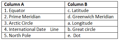
D. Match the columns A and B.
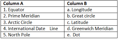
Ans:
Writing Zone
Answer the following questions.
Q1: Look at the diagrams given. Some numbers have been given on the lines and areas. Name them.
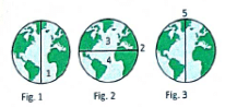
Ans:
1. South Pole
2. Equator
3. Northern Hemisphere
4. Southern Hemisphere
5. Prime Meridian
2. What is a grid?
Ans: A grid is a network of lines formed by parallels (latitudes) and meridians (longitudes) on the Earth's surface. It helps to locate a place by giving its latitude and longitude, which meet at a point on the grid.
3. Name the following:
(a) 0° Latitude: ________
(b) 23½° N Latitude: ________
(c) 23½° S Latitude: ________
(d) 66½° N Latitude: ________
(e) 66½° S Latitude: ________
(f) 90° N: ________
(g) 90° S: ________
(h) What is the difference between latitudes and longitudes?
(i) What is the Prime Meridian? Give its other names. Why is it called so?
Ans: (a) 0° Latitude: Equator
(b) 23½° N Latitude: Tropic of Cancer
(c) 23½° S latitude: Tropic of Capricorn
(d) 66½° N Latitude: Arctic Circle
(e) 66½° S Latitude: Antarctic Circle
(f) 90° N: North Pole
(g) 90° S: South Pole
(h) Latitudes: Horizontal circles that run east-west; measured in degrees north or south of the Equator; their distance apart decreases towards the Poles. Longitudes: Vertical semi-circles that run north-south; measured in degrees east or west of the Prime Meridian; all longitudes have the same length and meet at the Poles.
(i) The Prime Meridian is the 0° longitude line passing through Greenwich near London. It is also called the Greenwich Meridian. It is called the Prime Meridian because it is the reference line from which longitudes are measured; this position was internationally agreed at the 1884 conference.
FAQs on Textbook Solutions: Latitudes and Longitudes
| 1. What are latitudes and longitudes? |  |
| 2. How do latitudes and longitudes help in navigation? | |
| 3. What is the significance of the Equator and the Prime Meridian in latitudes and longitudes? | |
| 4. How are latitudes and longitudes measured? | |
| 5. Can latitudes and longitudes be used to determine time zones? | |


