High clouds primarily reflect solar radiation and cool the surface of the Earth.
Low clouds have a high absorption of infrared radiation emanating from the Earth's surface and thus cause warming effect.
Which of the statements given above is/are correct? (a) 1 only (b) 2 only (c) Both 1 and 2 (d) Neither 1 nor 2
Solution:
Ans: (d)
Explanation: High clouds (for example, cirrus) are generally thin and relatively transparent to incoming solar radiation, so they do not reflect much sunlight; however, they are effective at trapping outgoing longwave (infrared) radiation from the Earth and can therefore produce a net warming effect. Low clouds (for example, stratus and stratocumulus) are thicker and more reflective, so they reflect a substantial portion of incoming solar radiation back to space and tend to have a net cooling influence at the surface. Thus, both given statements are incorrect.
Q2: Consider the following States:
Andhra Pradesh
Kerala
Himachal Pradesh
Tripura
How many of the above are generally known as tea-producing States? (a) Only one State (b) Only two States (c) Only three States (d) All four States
Solution:
Ans: (d)
Explanation: Tea is grown in several parts of India beyond the major centres (Assam, Darjeeling, West Bengal and Tamil Nadu). Kerala is a well-known tea-producing State. Himachal Pradesh cultivates tea in its hill regions. Andhra Pradesh and Tripura also have areas where tea is produced. Therefore, all four listed States are known to produce tea.
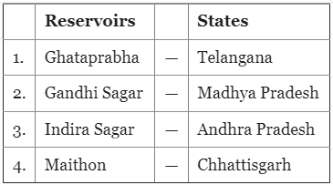
Q3: Consider the following pairs:
How many pairs given above are not correctly matched? (a) Only one pair (b) Only two pairs (c) Only three pairs (d) All four pairs
Solution:
Ans: (c)
Ghataprabha Reservoir - Telangana: Incorrect. Ghataprabha Reservoir is located in Karnataka.
Gandhi Sagar - Madhya Pradesh: Correct. Gandhi Sagar Reservoir is in Madhya Pradesh.
Indira Sagar - Andhra Pradesh: Incorrect. Indira Sagar Reservoir is in Madhya Pradesh.
Maithon - Chhattisgarh: Incorrect. Maithon Reservoir is in Jharkhand (on the Barakar River).
Explanation: Three of the four pairs are mismatched (Ghataprabha, Indira Sagar and Maithon). Only Gandhi Sagar is correctly placed in Madhya Pradesh. Hence option (c) is correct.
Q4: Which one of the following lakes of West Africa has become dry and turned into a desert? (a) Lake Victoria (b) Lake Faguibine (c) Lake Oguta (d) Lake Volta
Solution:
Ans: (b)
Explanation: Lake Faguibine in Mali has largely dried up and turned into desert-like land in recent decades. This loss of water has been attributed to prolonged droughts, upstream water diversions and broader climatic variability in the region. The drying of Lake Faguibine has been highlighted in international discussions on climate and regional environmental change.
Q5: Gandikota canyon of South India was created by which one of the following rivers? (a) Cauvery (b) Manjira (c) Pennar (d) Tungabhadra
Solution:
Ans: (c)
Explanation: Gandikota canyon, often called the "Grand Canyon of India", is formed by the Pennar River cutting through the Erramala hills in Kadapa district of Andhra Pradesh. The steep rocky gorge and the valley scenery are the result of long-term river erosion by the Pennar.
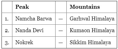
Q6: Consider the following pairs:
Which of the pairs given above is/are correctly matched? (a) 1 and 2 (b) 2 only (c) 1 and 3 (d) 3 only
Solution:
Ans: (b)
Explanation: Key relevant facts:
Nanda Devi peaks are part of the Kumaon Himalaya.
The region of the Himalaya between the Sutlej and the Kali (or Sharda) rivers is known as the Kumaon Himalaya.
The Greater Himalaya (or Himadri) extends from Nanga Parbat in the west to Namcha Barwa in the east; Namcha Barwa lies in the Tibetan region.
Considering these points, only the pair that identifies Nanda Devi with the Kumaon Himalaya is correct, so option (b) is correct.
Q7: The term "Levant" often heard in the news roughly corresponds to which of the following regions? (a) Region along the eastern Mediterranean shores (b) Region along North African shores stretching from Egypt to Morocco (c) Region along Persian Gulf and Horn of Africa (d) The entire coastal areas of Mediterranean Sea
Solution:
Ans: (a)
Explanation: The Levant refers to the eastern coastal lands of the Mediterranean Sea. It broadly covers the strip of territory between the Mediterranean in the west and the Arabo-Syrian Desert in the east, extending roughly from the mouth of the Orontes River in the north down to the Isthmus of Suez in the south. It does not denote the whole Mediterranean coast or the North African or Persian Gulf coasts.
Q8: Consider the following countries:
Azerbaijan
Kyrgyzstan
Tajikistan
Turkmenistan
Uzbekistan
Which of the above have borders with Afghanistan? (a) 1, 2 and 5 only (b) 1, 2, 3 and 4 only (c) 3, 4 and 5 only (d) 1, 2, 3, 4 and 5
Solution:
Ans: (c)
Explanation: Of the listed countries, the ones that share a land border with Afghanistan are:
Tajikistan (3)
Turkmenistan (4)
Uzbekistan (5)
Azerbaijan and Kyrgyzstan do not border Afghanistan. Therefore, option (c) is correct.
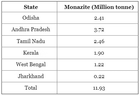
Q9: With reference to India, consider the following statements?
Monazite is a source of rare earths.
Monazite contains thorium.
Monazite occurs naturally in the entire Indian coastal sands in India.
In India, Government bodies only can process or export monazite.
Which of the statements given above are correct? (a) 1, 2 and 3 only (b) 1, 2 and 4 only (c) 3 and 4 only (d) 1, 2, 3 and 4
Solution:
Ans: (b)
Explanation:
Monazite is an important mineral that is a source of rare earth elements and it contains thorium. Key points:
Monazite is found in India and in other countries such as Madagascar and South Africa.
Monazite provides rare earth elements (for example cerium and lanthanum) and contains thorium, a radioactive element.
Monazite is not present uniformly along the entire Indian coastline; it occurs in specific beach-sand deposits.
Processing and export of monazite are controlled by government authorities: private firms are restricted from processing or exporting monazite, and operations involving monazite are subject to oversight by the Department of Atomic Energy. Earlier liberalisation allowed private mining of some beach minerals, but restrictions remain for monazite-rich sands (an amendment in 2016 barred private companies from mining beach sand with monazite concentration above a specified limit).
Given these facts, statements 1, 2 and 4 are correct while statement 3 is incorrect; hence option (b) is correct.
Q10: In the northern hemisphere, the longest day of the year normally occurs in the: (a) First half of the month of June (b) Second half of the month of June (c) First half of the month of July (d) Second half of the month of July
Solution:
Ans: (b)
Explanation: The longest day in the northern hemisphere normally occurs at the summer solstice, which falls around 21 June (the second half of June). On this date the Sun reaches its maximum northerly declination and daylight hours are greatest in the northern hemisphere.
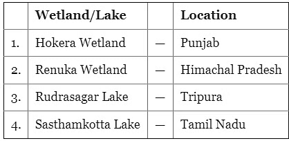
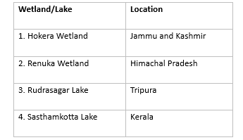
Q11: Consider the following pairs:
How many pairs given above are correctly matched? (a) Only one pair (b) Only two pairs (c) Only three pairs (d) All four pairs
Solution:
Ans: (b)
Hokera Wetland - Punjab: Incorrect. Hokera Wetland is in Jammu and Kashmir.
Renuka Wetland - Himachal Pradesh: Correct. Renuka Lake and its wetland are in Himachal Pradesh.
Rudrasagar Lake - Tripura: Correct. Rudrasagar Lake (also called Rudra Sagar) is in Tripura.
Sasthamkotta Lake - Tamil Nadu: Incorrect. Sasthamkotta Lake is located in Kerala.
Two of the four pairs are correctly matched (Renuka and Rudrasagar). The other two are mismatched. Hence option (b) is correct.
The document UPSC Prelims Previous Year Questions 2022: Geography is a part of the UPSC Course Geography for UPSC CSE.
FAQs on UPSC Prelims Previous Year Questions 2022: Geography
1. What are the key geographical features of India that are important for the UPSC Prelims?
Ans. India has diverse geographical features that include the Himalayan mountain range in the north, which influences climate and weather patterns; the Indo-Gangetic Plains that support agriculture; the Thar Desert in the west; the Western and Eastern Ghats that are significant for biodiversity; and extensive coastlines along the Indian Ocean, Arabian Sea, and Bay of Bengal which are crucial for trade and fishing.
2. How does the monsoon season affect the geography and agriculture of India?
Ans. The monsoon season, occurring from June to September, is critical for India's agriculture as it provides approximately 70% of the annual rainfall. This seasonal rain influences crop patterns, supporting the cultivation of rice, pulses, and other staples. The geography of India, including river systems and soil types, interacts with monsoon patterns to affect agricultural productivity and resource distribution.
3. What role do rivers play in the geography of India?
Ans. Rivers in India, such as the Ganga, Yamuna, Brahmaputra, and Indus, are vital for water supply, irrigation, and transportation. They shape the landscape through erosion and sediment deposition, create fertile plains, and support dense populations. Rivers also play a key role in cultural and religious practices, serving as sites for rituals and festivals.
4. What are the significant climatic zones in India, and how do they influence the environment?
Ans. India has several climatic zones, including tropical wet, tropical dry, subtropical humid, and alpine. These zones influence the environment by affecting biodiversity, vegetation types, and agricultural practices. For instance, the tropical wet zone supports dense forests, while the dry zones are characterized by arid landscapes and limited vegetation.
5. How do human activities impact the geographical environment of India?
Ans. Human activities such as urbanization, deforestation, and industrialization significantly impact India's geographical environment. Urban sprawl leads to habitat loss and pollution, while deforestation contributes to soil erosion and climate change. Agriculture practices can both sustain and degrade land, affecting water resources and biodiversity. Sustainable practices are essential to mitigate these impacts.
Semester Notes, Previous Year Questions with Solutions, Sample Paper, Extra Questions, ppt, pdf , Exam, Objective type Questions, practice quizzes, video lectures, Important questions, study material, past year papers, UPSC Prelims Previous Year Questions 2022: Geography, MCQs, mock tests for examination, Free, UPSC Prelims Previous Year Questions 2022: Geography, UPSC Prelims Previous Year Questions 2022: Geography, Viva Questions, Summary, shortcuts and tricks;