Year 7 Exam > Year 7 Notes > Atlas
Atlas

Introduction
- Atlases showcase a variety of maps at different scales, encompassing physical, political, or thematic information.
- They are valuable tools but come with certain limitations.
What is an atlas?
An atlas is a comprehensive book containing diverse maps at various scales.
Types of Maps
Physical Maps
- Physical maps primarily focus on illustrating the natural aspects of Earth's surface, such as geographical formations and water bodies.
Political Maps
- Political maps emphasize national borders and key urban centers, aiding in the understanding of political divisions and administrative regions.
Thematic Maps
- Thematic maps delve into specific themes or subjects, like climate patterns, economic indicators, or ecological regions, to provide a focused perspective on particular aspects of interest.
- Choropleth maps, a type of thematic map, use color gradients to represent data values across different regions, enabling easy visualization and comparison of quantitative information.
Moreover, atlases commonly include supplementary data such as country statistics tables detailing metrics like life expectancy and economic measures.
Limitations of Atlases
- Atlases, while useful, have shortcomings compared to Geographic Information Systems (GIS) software.
- GIS software connects geographical data to form digital map layers, offering more detailed and interactive information than atlases.
- Unlike atlases, GIS allows zooming in to street-level views and the addition or removal of map layers like aerial photography.
- Atlases quickly become outdated, but updating them is more challenging than online platforms.
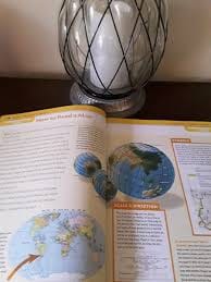
Understanding the Mercator Projection
- Limitations of Flat Maps: One of the drawbacks of using flat maps like atlases is their distortion of the Earth, which is actually a spherical, 3D shape.
- Mercator Projection Overview: The primary map projection in use is the Mercator projection, chosen for its specific advantages.
- Criticism of the Mercator Projection: One major critique is that it distorts the sizes of landmasses, portraying those farther from the equator as larger than they are in reality.
- Example of Distortion: For instance, on a Mercator map, Greenland appears to be as large as Africa, whereas Africa is actually 14 times larger.
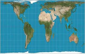
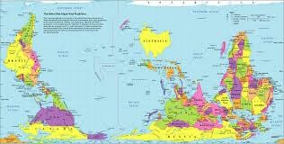
The Peters World Map
- The Peters World Map, also known as the Gall-Peters projection, is an alternative map projection that aims to represent landmasses in correct relative sizes.
- Unlike some traditional map projections that distort the sizes of continents, the Peters World Map shows landmasses in a more accurate size relationship to each other.
- However, even in this projection, there are distortions present, with areas appearing stretched near the equator and compressed towards the poles.
- The equator is an imaginary line that encircles the Earth, marking the boundary between the Northern and Southern hemispheres.
- An example of a distortion on the Peters World Map is that countries near the poles might appear smaller than they actually are in reality.
Finding locations in an atlas
Atlases always feature a table of contents and an index to facilitate locating specific maps or places.
Table of contents
- The table of contents is typically located at the beginning of the atlas and outlines the main sections included in the atlas in page number order.
- These sections are commonly categorized by continent, but other sections like satellite images or statistical tables may also be present.
Index
- The index, situated at the end of the atlas, alphabetically lists towns, cities, countries, and continents.
- Each place name in the index is accompanied by a reference to all the pages in the atlas where that location is featured. It's common for a town or city to be represented on multiple maps at various scales and covering diverse topics.
Latitude and Longitude
- Latitude and Longitude Coordinates:
- Coordinates represent the position of a point on a grid.
- Latitude and Longitude on World Maps:
- World maps are divided into a grid showing latitude and longitude.
- Latitude is measured east to west around the Earth, while longitude is measured north to south.
- Both latitude and longitude are measured in degrees, with each degree further divided into minutes.
- Example: Liverpool's Location:
- The city of Liverpool is situated at 53 degrees and 24 minutes north of the Equator (0° latitude).
- It is also positioned at 2 degrees and 58 minutes west of the Prime Meridian (0° longitude).
- Therefore, Liverpool's location can be expressed as 53°24'N, 2°58'W.
Latitude
On a world map, certain lines of latitude are named. There are five main lines of latitude:
- The Arctic Circle at 66.5 degrees North
- The Tropic of Cancer at 23.5 degrees North
- The Equator at 0 degrees
- The Tropic of Capricorn at 23.5 degrees South
- The Antarctic Circle at 66.5 degrees South
These lines help in understanding the positioning of places on Earth in relation to the Equator and the poles.
Longitude
- Longitude lines are not named extensively. The two main lines of longitude are the Prime Meridian (located at 0 degrees) and the International Date Line (approximately at 180 degrees).
- When crossing the International Date Line, there is a change in the calendar date. For instance, a ship traveling eastward across the Pacific Ocean and crossing the line might find the date moving back by a day. On the contrary, a westward journey could result in jumping ahead by a day.
MULTIPLE CHOICE QUESTIONTry yourself: What type of map focuses on illustrating the natural aspects of Earth's surface, such as geographical formations and water bodies?
FAQs on Atlas
| 1. What is the importance of using latitude and longitude in an atlas? |  |
Ans. Latitude and longitude are important coordinates used to pinpoint locations accurately on a map. Latitude measures how far north or south a location is from the equator, while longitude measures how far east or west a location is from the Prime Meridian. Together, they provide a precise location for any place on Earth.
| 2. How can I find a specific location in an atlas? | |
Ans. To find a specific location in an atlas, you can use the index or table of contents. These sections list the page numbers where different places are located in the atlas. You can then turn to the correct page and use the grid system or key to locate the exact position of the place you are looking for.
| 3. What are some common limitations of using atlases? | |
Ans. Some common limitations of atlases include limited detail, outdated information, lack of real-time updates, and difficulty in representing three-dimensional features on a two-dimensional map. It's important to supplement information from atlases with other sources for more comprehensive and up-to-date data.
| 4. Can I use an atlas to navigate while traveling? | |
Ans. While atlases can be useful for understanding the overall geography of an area, they may not always provide the most up-to-date or detailed information for navigation purposes. It is recommended to use GPS devices, maps, or online mapping tools for more accurate and real-time navigation assistance while traveling.
| 5. What distinguishes an atlas from other types of maps? | |
Ans. An atlas is a collection of maps usually organized by region or theme. Unlike a single map, an atlas provides a comprehensive overview of various geographical features, including political boundaries, physical landscapes, and cultural landmarks. Atlases often include additional information such as indexes, legends, and supplementary data to enhance the user's understanding of the world.
About this Document

Apr 21, 2026 Last updated
Related Exams
Document Description: Atlas for Year 7 2026 is part of Year 7 preparation. The notes and questions for Atlas have been prepared according to the Year 7 exam syllabus. Information about Atlas covers topics like and Atlas Example, for Year 7 2026 Exam. Find important definitions, questions, notes, meanings, examples, exercises and tests below for Atlas.
Description
Atlas of covers all the important topics, helping you prepare for the Year 7 exam on EduRev. Start for free!
Information about Atlas
In this doc you can find the meaning of Atlas defined & explained in the simplest way possible. Besides explaining types of Atlas theory, EduRev gives you an ample number of questions to practice Atlas tests, examples and also practice Year 7 tests.
Related Searches
Free, shortcuts and tricks, Objective type Questions, Exam, past year papers, Sample Paper, Atlas, Extra Questions, Important questions, Viva Questions, practice quizzes, Atlas, study material, Semester Notes, Summary, video lectures, ppt, MCQs, Atlas, mock tests for examination, pdf , Previous Year Questions with Solutions;