CBSE Sample Question Paper (2023-24) - 2 | Geography Class 11 - Humanities/Arts PDF Download
Time : 3 Hours
Maximum Marks : 80
General Instructions
- This question paper contains 30 questions. All questions are compulsory.
- This question paper is divided into five sections. Sections – A, B, C, D and E.
- Section A – Question number 1 to 17 are Multiple Choice Type Questions carrying 1 mark each.
- Section B – Question number 18 and 19 are Source Based Questions carrying 3 marks each.
- Section C – Question number 2D to 23 are Short Answer Type Questions carrying 3 marks each. Answer to these questions shall be written in 80 to 100 words.
- Section D – Question number 24 to 28 are Long Answer Type Questions carrying 5 marks each. Answer to these questions shall be written in 120 to 150 words.
- Section E – Question number 29 and 30 are Map based questions.
Section – A
Q1. There are two statements marked as Assertion (A) and Reason (R). Mark your answer as per the codes provided below. 1
Assertion: Carbon dioxide is largely responsible for the greenhouse effect.
Reason: The volume of carbon dioxide is rising which has also increased the temperature of the air.
Options:
(A) Both (A) and (R) are true but (R) is not the correct explanation of (A).
(B)- Both (A) and (R) are true and (R) is the correct explanation of (A).
(C) Both (A) and (R) are incorrect.
(D) (A) is correct but (R) is incorrect.
Ans: Option (B) is correct.
The volume of carbon dioxide is rising due to the burning of fossil fuels, as a result, the temperature is increasing.
Q2. Consider the following and choose the correct answer with the help of given codes 1
Options: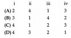 Ans: Option (C) is correct.
- Troposphere: The layer closest to the Earth where temperature decreases as it goes higher which is known as the Normal lapse rate.
- Stratosphere: The second layer of the atmosphere contains the Ozone layer that helps protect us from the sun’s harmful rays.
- Mesosphere: Above the stratosphere, the meso¬sphere gets colder as you go higher up temperature decreases drastically.
- Ionosphere: This layer contains the charged particles and helps in reflecting radio waves and also because of this temperature increases as we go higher.
Q3. The Coriolis Force is the maximum at the: 1
(A) Equator
(B) Poles
(C) Arctic Circle
(D) Antarctic Ocean
Ans: Option (B) is correct.
Earth’s rotational effects on horizon-tally and freely moving objects are greatest at the poles, therefore, the Coriolis effect is greatest at the poles.
Q4. Consider the following statements and choose the correct answer with the help of the given option: 1
I. Ocean currents have no influence on human activities.
II. The best fishing grounds of the world exist in mixing zone where warm and cold currents meet
Options:
(A) Both statements are true.
(B) Only statement I is true.
(C) Only statement II is true.
(D) Both statements are wrong.
Ans: Option (C) is correct.
As the best fishing grounds in the world exist in a mixing zone where warm and cold currents meet so it can be said that the Ocean currents have direct and indirect influences on human activities.
Q5. Given below is a list of climatic phenomena and their types according to classification, which of the following pair
is not correctly matched? 1
Ans: Option (B) is correct.
Tropical cyclones originate over the Bay of Bengal and the Indian Ocean.
Q6. The term ‘Holistic Approach’ is related to: 1
(A) overall approach
(B) individualistic approach
(C) seasonal approach
(D) formal approach
Ans: Option (A) is correct.
The term ‘Holistic Approach’ means looking at the bigger picture and considering everything together, rather than just focusing on small parts.
Q7. Which of the following features can be termed as physical feature? 1
(A) Pbrt
(B) Road
(C) Plain
(D) Water park
Ans:
Option (C) is correct.
Physical features refer to natural landforms, and a ‘plain’ is a type of flat or gently rolling land with no significant elevation changes.
Q8. The earth has a ……………… structure:
(A) Layered
(B) Non-layered
(C) Piled on
(D) Single
Ans:
Option (A) is correct.
The Earth has a layered structure, meaning it is composed of several distinct layers like a set of nesting dolls. These layers include the crust, mantle, outer core, and inner core, each with unique properties and compositions.
Q9. Which one of the following countries is larger in area than India?
(A) China
(B) Egypt
(C) France
(D) Iran
Ans: Option (A) is correct.
China is larger in land area than India, making it one of the world’s largest countries by size.
Q10. Consider the following statements and choose the correct answer with the help of given options:
Statement I: Forests have an intricate interrelationship with life and the environment.
Statement II: The government adopted a forest policy in 1952 and modified it in 1988.
(A) Only statement I is correct.
(B) Only statement II is correct.
(C) Both the statements are correct, and statement II correctly explains statement I.
(D) Both the statements are true but not related with each other.
Ans: Option (C) is correct.
In order to conserve and expand forest reserve on one hand and to meet the needs of local people on the other, forest policy was adopted.
Q11. Arrange the following approaches in the correct order according to their development: 1
(i) Spatial organisation
(ii) Regional approach
(iii) Areal differentiation
(iv) Humanistic approach
Options:
(A) i, ii, iv, iii
(B) ii, iii, i, iv
(C) iii, iv, ii, i
(D) iii, i, ii, iv
Ans: Option (B) is correct.
(ii) Regional approach: People first began to look at and understand larger areas as regions, noticing similarities and differences in those areas.
(iii) Areal differentiation: As they explored regions more, they started to differentiate between different areas based on their unique characteristics and features.
(i) Spatial organisation: With a better understanding of regions and areas, they organized the space around them, figuring out how things are arranged and connected.
(iv) Humanistic approach: Finally, they began to consider how people and their activities impact and are influenced by the environment, leading to the humanistic approach that focuses on the relationship between humans and their surroundings.
Q12. Monpa, Daffla, Abor, Mishmi, Nishi and the Nagas tribes live in the: 1
(A) Kashmir Himalayas
(B) Sikkim Himalayas
(C) Arunachal Himalayas
(D) Northwestern Himalayas
Ans: Option (C) is correct.
The Monpa, Daffla, Abor, Mishmi, Nishi, and Nagas tribes live in the Arunachal Himalayas, which is in the northeastern part of India.
Q13. Khadar and the Bhangar are divisions of: 1
(A) Alluvial plains
(B) Ganga plains
(C) Brahmaputra plains
(D) Northern plains
Ans: Option (A) is correct.
Khadar and Bhangar are divisions found in alluvial plains, which are flat lands formed by sediment deposits from rivers like the Ganga and Brahmaputra.
Q14. Which one of the following countries shares the longest land frontier with India : 1
(A) Bangladesh
(B) China
(C) Pakistan
(D) Myanmar
Ans: Option (A) is correct.
Bangladesh shares the longest land border with India. This border is quite extensive, stretching over approximately 4,096 kilometres.
Read the following graph and answer questions no 15 to 17.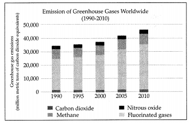 Q15.Which gas had the maximum emission in 2010? 1
(A) Methane
(B) Carbon dioxide
(C) Fluorinated gases
(D) None of the above
Ans: Option (B) is correct.
Carbon dioxide had the highest emissions in 2010, making it the primary greenhouse gas contributor.
Q16. Which gas had the minimum emission in 1990? 1
(A) Nitrous oxide
(B) Methane
(C) Fluorinated gases
(D) Carbon dioxide
Ans: Option (C) is correct.
Fluorinated gases had the lowest emissions in 1990 among the listed gases.
Q17. How much Methane was emitted in 2005? 1
(A) Between 30,000 – 40,000 metric tons
(B) Between 40,000 – 50,000 metric tons
(C) Between 60,000 – 70,000 metric tons
(D) Between 20,000 – 30,000 metric tons
Ans: Option (A) is correct.
Between 30,000 – 40,000 metric tons of Methane were emitted in 2005.
Section – B
Q18 & 19 are Source Based Questions.
Q18. Read the given Passage carefully and answer the questions that follow: 3
Normally, temperature decreases with an increase in elevation. It is called the normal lapse rate. At times, the situations are reversed and the normal lapse rate is inverted. It is called inversion of temperature. Inversion is usually of short duration but quite common nonetheless. A long winter night with a clear sky and still air is an ideal situation for inversion. The heat of the day is radiated off during the night and by early morning hours, the earth is cooler than the air above. Over polar areas, temperature inversion is normal throughout the year. Surface inversion promotes stability in the lower layers of the atmosphere. Smoke and dust particles get collected beneath the inversion layer and spread horizontally to fill the lower strata of the atmosphere. Dense fogs in the mornings are common occurrences, especially during the winter season. This inversion commonly lasts for few hours until the sun comes up and brings warmth to the earth. The inversion takes place in hills and mountains due to air drainage. Cold air at the hills and mountains, produced during night, flows under the influence of gravity. Being heavy and dense, the cold air acts almost like water and moves down the slope to pile up deeply in pockets and valley bottoms with warm air above. This is called air drainage. It protects plants from frost damages.
a. When does the temperature decrease?
b. When does inversion in temperature occurs?
c. For how long can inversion last?
Ans:
a. With the increase in elevation the temperature decreases.
b. On clear nights the inversion in temperature occurs.
c. Till the sun comes up the inversion lasts.
Q19. Observe the below given map and answer the following. 3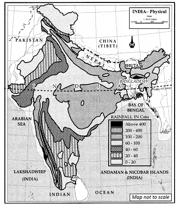 a. Name any one state that receives the minimum rainfall.b. Name any two states that are receiving rainfall between 400 – 200 cm.
c. Identify one state that is receiving rainfall between 40 – 20 cm.
Ans:
a. Rajasthan, receives rainfall between 0 – 60 cm.
b. Odissa and Chhattisgarh receive rainfall between 400 – 200 cm.
c. Tamil Nadu receives rainfall between 40 – 20 cm.
Section – C
Question Numbers 20 to 23 are Short Answer Type Questions.
Q20. Name the various hypothesis associated with the formation of the earth. 3
OR
How the inner planets are terrestrial while outer planets are Jovian? Explain. 3
Ans: The various hypothesis associated with the formation of the earth are:
- Nebular Hypothesis: It was given by Laplace. The hypothesis considered that the planets were formed out of a cloud of material associated with a youthful sun that was slowly rotating.
- Collision Hypothesis: It was given by Sir James and Harold Jeffrey. This theory suggests that the moon was formed out of the debris left over from a collision between the Earth and an astronomical body the size of Mars, approximately 4.5 billion years ago.
- Accretion Hypothesis: It was given by Schmidt and Carl Weizascar. This hypothesis argues that about 4.6 million years ago our solar system was formed from a cloud of gas and dust which slowly contracted under the mutual gravity of all its particles.
- The Big Bang Theory: It was given by Edwin Hubble. He argued that the universe was ever-expanding. As time passes, galaxies move further and further apart. (Any three)
OR
- Inner planets are terrestrial while the other planets are Jovian because the terrestrial planets are much smaller and hold less gravity and are thus unable to hold the escaping gases.
- Jovian planets being bigger in size have high gravity. The solar winds also are more intense near the sun, so it blows off a lot of gas and dust from the terrestrial planets.
- The solar winds are not that intense to cause similar removal of gases from the Jovian planets.
Q21. When does condensation take place? 3
Ans:
In free air, condensation results from cooling around very small particles termed as hygroscopic condensation nuclei. Particles of dust, smoke and salt from the ocean are particularly good nuclei because they absorb water. Condensation also takes place when the moist air comes in contact with some colder object and it may also take place when the temperature is close to the dew point. Condensation, therefore, depends upon the amount of cooling and the relative humidity of the air.
Condensation takes place:
- When the temperature of the air is reduced to a dew point with its volume remaining constant.
- When both the volume and the temperature are reduced.
- When moisture is added to the air through evaporation.
- However, the most favourable condition for condensation is the decrease in air temperature.
Q22. Into how many geological divisions can India be divided? Briefly explain them. 3
OR
Write a note on Thar Desert.
Ans: India can be divided into three geological divisions:
(i) The Peninsular Block: The northern boundary of the Peninsular Block may be taken as an irregular line running from Kachchh along the western flank of the Aravali Range near Delhi and then roughly parallel to the Yamuna and the Ganga as far as the Rajmahal Hills and the Ganga delta. Apart from these, the Karbi Anglong and the Meghalaya Plateau in the North East and Rajasthan in the West are also extensions of this block.
(ii) The Himalayas and other Peninsular Mountains: The Himalayas along with other Peninsular mountains are young, weak and flexible in their geological structure. Consequently, they are still subjected to the interplay of exogenic and endogenic forces, resulting in the development of faults, folds and thrust plains. These mountains are tectonic in origin, dissected by fast-flowing rivers which are in their youthful stage.
(iii) Indo-Ganga-Brahmaputra Plain: The third geo¬logical division of India comprises the plains formed by the river Indus, the Ganga and the Brahmaputra. The average depth of alluvial deposits in these plains ranges from 1,000-2,000
OR
- To the northwest of the Aravali hills lies the Great Indian desert. It is a land of undulating topography dotted with longitudinal dunes and barchans. This region receives low rainfall below 150 mm per year; hence, it has an arid climate with low vegetation cover. It is because of these characteristic features that this is also known as Marusthali.
- The vegetation common in the region are Cacti, Kher, Kikar, Babool, Aclacia, Rhododendrons, etc. During the rainy season, some streams appear which disappear in summer. Luni is an important river in the region.
- Some of the well-pronounced desert land features present here are mushroom rocks, shifting dunes and oasis. On the basis of the orientation, the desert can be divided into two parts: the northern part is sloping towards Sindh and the southern towards the Rann of Kachchh. Most of the rivers in this region are ephemeral.
Q23. Explain the important features of the Brahmaputra River System. 3
Ans: The Brahmaputra River System:
(i) The Brahmaputra, one of the largest rivers in the world, has its origin in the Chemayungdung Glacier of the Kailash range near the Mansarovar Lake. From here, it traverses eastward longitudinally for a distance of nearly 1,200 km in a dry and flat region of southern Tibet, where it is known as the Tsangpo, which means ‘the purifier.’
(ii) The Brahmaputra receives numerous tributaries in its 750 km long journey through the Assam valley.
(iii) The Brahmaputra is well-known for floods, channel shifting and bank erosion. This is due to the fact that most of its tributaries are large, and bring large quantities of sediments owing to heavy rainfall in its catchment area.
Section – D
Question Numbers 24 to 28 are Long Answer Type Questions.
Q24. What do you know about the different types of earthquake waves? 5
Ans: Earthquake waves are of two types:
1. Body waves: Body waves are generated due to the release of energy at the focus and move in all directions travelling through the body of the earth. Hence, the name body waves. Body waves are further divided into two types:
(a) P-waves: P-waves move faster and are the first to arrive at the surface. These are also called ‘primary waves’. The P-waves are similar to sound waves. They travel through gaseous, liquid and solid materials.
(b) S-waves: S-waves arrive at the surface with some time lag. These are called secondary waves. An important fact about S-waves is that they can travel only through solid materials. This characteristic of the S-waves is quite important. It has helped scientists to understand the structure of the interior of the earth. Reflection causes waves to rebound whereas refraction makes waves move in different directions. The variations in the direction of waves are inferred with the help of their record on seismographs. The surface waves are the last to report on seismographs. These waves are more destructive. They cause the displacement of rocks, and hence, the collapse of structures occurs.
2. Surface waves: The body waves interact with the surface rocks and generate a new set of waves called ‘surface waves. These waves move along the surface and are more destructive. They cause displacement of rocks and hence, the collapse of structures occurs. The velocity and direction of waves changes as they travel through materials with different densities.
Q25. Explain in detail the five basic factors that control the formation of soils. 5
Ans: The five factors that control the formation of soils are:
(i) Parent Material: Parent material is a passive control factor in soil formation. Soil formation depends upon the texture (sizes of debris) and structure (disposition of individual grains/particles of debris) as well as the mineral and chemical composition of the rock debris/deposits.
(ii) Topography: The influence of topography is felt through the amount of exposure of a surface covered by parent materials to sunlight and the amount of surface and subsurface drainage over and through the parent materials. Soils will be thin on steep slopes and thick over flat upland areas. Over gentle slopes where erosion is slow and percolation of water is good, soil formation is very favourable.
(iii) Climate: The climatic elements involved in soil development are
(i) moisture in terms of its intensity, frequency and duration of precipitation – evaporation and humidity;
(ii) temperature in terms of seasonal and diurnal variations. Precipitation gives soil its moisture content which makes chemical and biological activities possible. Excess water helps in the downward transportation of soil components through the soil (eluviation) and deposits the same down below (illuviation). Temperature acts in two ways – increasing or reducing chemical and biological activity.
(iv) Biological Activity: The vegetative cover and organisms that occupy the parent materials from the beginning and also at later stages help in adding organic matter, moisture retention, nitrogen, etc. Dead plants provide humus, the finely divided organic matter of the soil. Further, bacteria and other soil organisms take gaseous nitrogen from the air and convert it into a chemical form that can be used by plants. This process is known as nitrogen fixation.
(v) Time: The length of time the soil forming processes operate, determines maturation of soils and profile development. A soil becomes mature when all soil-forming processes act for a sufficiently long time developing a profile.
Q26. How is Bhabar different from Tarai? 5
OR
How are the Himalayan rivers different from the Peninsular rivers?
Ans:
OR
Following are the important difference between Himalayan rivers and peninsular rivers.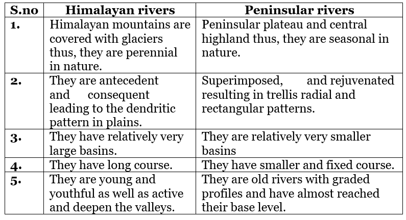
Q27. Write a note on Coriolis Force. 5
OR
What are the forms of condensation? Describe the process of dew and frost formation.
Ans:
- The rotation of the earth about its axis, affects the direction of the wind. This force is called the Coriolis Force after the French physicist who described it in 1844.
- It deflects the wind to the right direction in the Northern Hemisphere and to the left in the Southern Hemisphere. The deflection is more when the wind velocity is high.
- The Coriolis force is directly proportional to the angle of latitude. It is maximum at the poles and is absent at the Equator. The Coriolis Force acts perpendicular to the pressure gradient force. The pressure gradient force is perpendicular to an isobar.
- The higher the pressure gradient force, the more the velocity of the wind and the larger the deflection in the direction of the wind. As a result of these two forces operating perpendicular to each other, in low-pressure areas, the wind blows around it.
- At the Equator, the Coriolis Force is zero and the wind blows perpendicular to the isobars. The low pressure gets filled instead of getting intensified. That is the reason why tropical cyclones are not formed near the Equator.
OR
The transformation of water vapour into water is called condensation. Condensation is caused by the loss of heat. When moist air is cooled, it may reach a level where its capacity to hold water vapour ceases. Condensation also takes place when the moist air comes in contact with some colder object and it may also take place when the temperature is close to the dew point. The various forms of condensation are:
- (i) Dew: When the moisture is deposited in the form of water droplets on cooler surfaces of solid objects (rather than nuclei in air above the surface) such as stones, grass blades and plant leaves, it is known as dew. The ideal conditions for its formation are clear sky, calm air, high relative humidity and cold and long nights. For the formation of dew, it is necessary that the dew point is above the freezing point.
- (ii) Frost: Frost forms on cold surfaces when conden-sation takes place below freezing point (00 C), i.e., the dew point is at or below the freezing point. The excess moisture is deposited in the form of minute ice crystals instead of water droplets. The ideal conditions for the formation of white frost are the same as those for the formation of dew, except that the air temperature must be at or below the freezing point.
Q28. Draw a simplified diagram to show the general circulation of the atmosphere over the globe. What are the possible reasons for the formation of subtropical high pressure over 30°N and S latitudes? 5
OR
What objectives have been determined for the conservation of forests according to National Forest Policy? 5
Ans: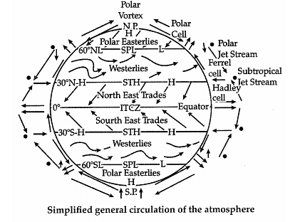 The air at the Inter Tropical Convergence Zone (ITCZ) rises because of convection caused by high insolation and a low pressure is created. The winds from the tropics converge at this low-pressure zone. The converged air rises along with the convective cell. It reaches the top of the troposphere up to an altitude of 14 km and moves towards the poles. This causes an accumulation of air at about 30°N and S. Part of the accumulated air sinks to the ground and forms a subtropical high. The cooling of air takes place when it reaches 30°N and S latitudes. Down below near the land surface, the air flows towards the Equator as the easterlies. The easterlies from either side of the equator converge in the Inter Tropical Convergence Zone (ITCZ).
In the middle latitudes, the circulation is that of sinking cold air that comes from the poles and the rising warm air that blows from the subtropical high. At polar latitudes, the cold dense air subsides near the poles and blows towards middle latitudes as the polar easterlies. The transfer of heat energy from lower latitudes to higher latitudes maintains general circulation. Thus, this forms the subtropical high pressure over 30°N and S latitudes.
OR
The forest policy is aimed at:
- Bringing 33 per cent of the geographical areas under forest cover;
- Maintaining environmental stability and restoring forests where ecological balance was disturbed;
- Conserving the natural heritage of the country, its biological diversity and genetic pool;
- Checks soil erosion, extension of the desert lands and reduction of floods and droughts;
- Increasing the forest cover through social forestry and afforestation on degraded land;
- Increasing the productivity of forests to make timber, fuel, fodder and food available to rural populations dependent on forests and encourage the substitution of wood;
- Creation of massive people’s movement involving women to encourage the planting of trees, stop the felling of trees and thus, reduce pressure on the existing forests.
Section – E
Question Numbers 29 & 30 are Map based questions having 5 sub-parts each.
Q29. On the outline map of India, show the following: 5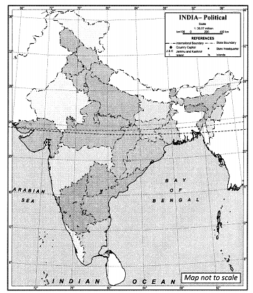 (A) Any one Area of winter rain(B)Any one Area of burst of monsoon in first week of june
(C) Any one Area having variability of rainfall over 50 per cent
(D) Any one Area having less than 15°C temperatures in January
(E) Isohyet of 100cm
(F) Any one Area has more than 200 cm of annual rainfall
(G) Any one Area having 40 – 60 cm seasonal rainfall
Ans: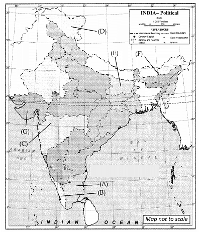 (A) Punjab or Haryana(B) Kerala
(C) Maharashtra
(D) Jammu and Kashmir
(E) Bihar
(F) Assam
(G) Gujarat (Any five)
Q30. On the outline map of the world, locate and mark any five of the following: 5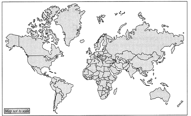 (A) West wind drift(B) North Atlantic drift
(C) Brazilian current
(D) Labrador current
(E) Equatorial counter current
(F) Kuroshio current
Ans: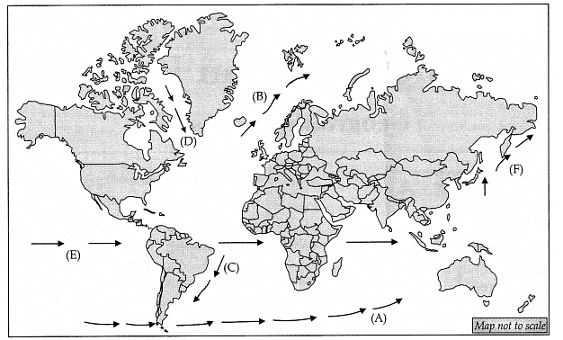 (A) West wind drift(B) North Atlantic drift
(C) Brazilian current
(E) Equatorial counter current
(F) Kuroshio current (Any five)
|
70 videos|289 docs|44 tests
|


