NCERT Solutions: Landforms and Life


The Big Questions
1. What are the major types of landforms and their significance to life and culture?
Ans: The major types of landforms are listed below. Each landform affects climate, human activity and culture in distinct ways.
- Mountains: Influence climate and weather. Provide habitats for diverse wildlife. Are sources of fresh water from melting snow and glaciers. Hold cultural and religious significance for many communities and attract tourism.
- Plateaus: Often rich in minerals and show varied local climates. Important for mining, grazing and some types of agriculture, especially where soils are fertile. Many plateaus are home to scenic waterfalls and unique cultures.
- Plains: Essential for agriculture because of fertile soils and easy access to water. Support large populations and human settlements. Provide favourable conditions for farming, transport and industrial development.
2. What are the challenges and opportunities of life associated with each landform?
Ans: The challenges and opportunities of life associated with each landform are as follows:
Mountains
Opportunities: Rich in minerals and forest resources; attract tourists which helps the local economy.
Challenges: Steep slopes, cold climate and limited transport make farming and communication difficult.
Plains
Opportunities: Fertile soil for crops; easy to build roads, cities and irrigation systems.
Challenges: Prone to flooding in heavy rains and can become overcrowded near towns and cities.
Plateaus
Opportunities: Contain mineral deposits and support grazing and some farming.
Challenges: Water may be scarce at the top and soils may be shallow, which limits large-scale farming.
Deserts
Opportunities: Rich in some minerals and very suitable for solar energy projects; unique plants and animals attract study and tourism.
Challenges: Lack of water and extreme temperatures make living and farming difficult.
Let's Explore (Page 42)
Q1. As a class activity, form groups of four or five students and observe the school's surroundings. What kind of landscape do you see? Will the landscape change a few kilometres away? Or within some 50 kilometres? Compare with other groups.
Ans: Observing the school's surroundings: Group observations and comparison
- Type of Landscape: Our school is in an urban area with buildings, roads, parks and some trees. There are few natural water bodies or hills very close by.
- Nearby Changes: A few kilometres away the area becomes more residential with smaller buildings, more gardens and open spaces.
- Changes within 50 Kilometres: Within about 50 kilometres we find rural areas with fields, farms, small forests, hills and a river in places - a clear change from the urban scene close to school.
- Comparison with Other Groups: Other groups reported similar observations. One group noticed an industrial area nearby, while another found a large lake about 30 kilometres away that we had not seen.
Class Discussion:
The area around our school is mainly urban and becomes greener and more open as we move away. These changes happen because of natural geography (rivers, hills) and human activities such as planning, farming and industry.
Q2. In the same groups, discuss a journey that any of you has made through a region of India. List the different landscapes seen on the way. Compare with other groups.
Ans: Journey description: Priya's trip from Delhi to Manali
- Delhi: Urban landscape with tall buildings, busy roads, crowded markets, parks and historical monuments.
- Haryana: Suburban and rural landscape with homes, agricultural fields and small villages on largely flat land.
- Punjab: Rural landscape with vast wheat and rice fields, villages and a system of canals; mostly flat.
- Himachal Pradesh: Mountainous landscape with steep slopes, winding roads, pine and deodar forests, rivers and streams.
- Manali: Alpine landscape with snow-capped peaks, green valleys, apple orchards and a mix of traditional wooden houses and modern buildings.
Comparison and Discussion
- Delhi to Haryana: A clear change from a busy city to quieter suburban and farming areas with more green cover.
- Haryana to Punjab: Continued rural and agricultural landscapes but with larger and more organised fields in Punjab.
- Punjab to Himachal Pradesh: A dramatic shift to hilly and mountainous terrain with higher altitude vegetation.
- Himachal Pradesh to Manali: Further changes include denser forests, valleys and snowy places as altitude increases.
Conclusion
Priya's journey from Delhi to Manali shows how quickly landscapes can change in India, from plains and farms to high mountains. These changes affect how people live, what they grow and their culture.
Think About It (Page 43)
Q. What is snow? Unless you live in a Himalayan region (such as Kashmir, Ladakh, Himachal Pradesh, Uttarakhand, Sikkim, Arunachal Pradesh), you may never have seen snow! In the rest of India, most precipitation is in the form of rain and hail. But at higher altitudes, if it is cold enough, snow will fall, covering the landscape in a soft and beautiful white blanket. Snow and hailstones are nothing but precipitation of water in a solid state.
Ans: Snow is frozen water that falls from the sky when temperatures are low. Water vapour in cold air forms tiny ice crystals that join together to make snowflakes. In high places such as the Himalayas - for example Kashmir, Ladakh, Himachal Pradesh, Uttarakhand, Sikkim and Arunachal Pradesh - these snowflakes fall and form a white cover. In most parts of India, temperatures are warmer so precipitation comes as rain or sometimes hail.
Key points about snow:
- Common in high-altitude areas like the Himalayas.
- In most of India, precipitation is mainly rain or hail because it is warmer.
- Snow forms when temperatures are low enough for water vapour to turn directly into ice crystals.
- Snow creates a white blanket over the land and affects local life, water supply and travel.
- Both snow and hail are solid forms of water and occur under cold conditions.
Page 49
Q. These images (Fig. 3.6 on page 50) depict a few challenges that people living in the mountains may face. Discuss them in groups in the class and write one paragraph on each. Also discuss why, despite many such challenges, people still choose to live in the mountains.
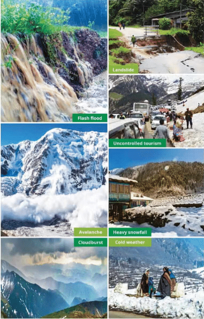
Ans: Challenges of living in the mountains and reasons why people stay
- Avalanches: An avalanche is a sudden slide of snow, ice and sometimes rocks down a slope. Avalanches can destroy homes and block roads, making travel and rescue difficult. People living in avalanche-prone zones learn warning signs and build homes in safer places to reduce risk.
- Landslides: Heavy rain, earthquakes or changes in land use can cause landslides that bury fields and houses. Landslides damage roads and cut off villages. Villagers use terracing, retaining walls and avoid building on very steep slopes to reduce danger.
- Heavy Snowfall: Deep snow can isolate communities, collapse roofs and stop transport. People adapt by strengthening roofs, keeping supplies and clearing paths regularly.
- Flash Floods: Sudden floods from heavy rain or quick snowmelt can wash away bridges, houses and crops. Early warnings, safe shelters and riverside protection help reduce harm.
- Uncontrolled Tourism: While tourists bring income, too many visitors can cause pollution, strain water supplies and harm nature. Villages try to manage tourism carefully so that local life and the environment are not damaged.
Why people still live in the mountains: Despite these risks, mountain life offers fresh air, natural beauty, unique crops and close communities. Many people depend on mountain forests, farming, animal rearing and tourism for their livelihood. Religious and cultural ties also keep communities in these areas.
Page 53
Q. Use the colour code in Fig. 3.8 to add a landform to each name. For instance, 'Tibetan plateau', 'Rocky range', 'Nile plain'.
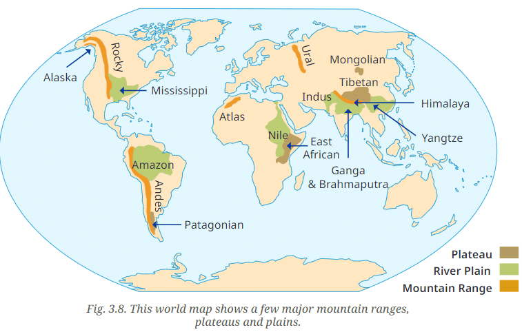
Ans:
Tibetan Plateau (Brown): The Tibetan Plateau, shown in brown, is the largest and highest plateau in the world and represents a high flat land.
Rocky Range (Orange): The Rocky Mountain Range, marked in orange, is a long chain of mountains along western North America.
Nile Plain (Green): The Nile River Plain is shown in green, indicating low-lying and fertile land beside the river.
Additional examples from the map:
- Amazon Plain (Green): The wide, low Amazon river plain in South America.
- Andes Range (Orange): The Andes mountain range in South America.
- East African Plateau (Brown): The plateau region of eastern Africa.
- Mississippi Plain (Green): The low-lying Mississippi river plain in the United States.
- Atlas Range (Orange): The Atlas mountains in North Africa.
- Patagonian Plateau (Brown): The plateau in southern South America.
- Himalaya Range (Orange): The Himalayan mountain range in Asia.
- Yangtze Plain (Green): The Yangtze river plain in China.
- Indus Plain (Green): The Indus river plain in South Asia.
- Ural Range (Orange): The Ural mountains in Russia.
- Ganga & Brahmaputra Plain (Green): The large plains formed by these rivers.
- Mongolian Plateau (Brown): The high plateau region of Mongolia.
- Alaska Range (Orange): Mountain range in Alaska.
Page 54
Q. The picture in Fig. 3.9 has been taken from a satellite. It captures a portion of north India from a high altitude. Observe and discuss the image as a class activity.
→ Which colour is the Ganga plain?
→ What does the white expanse represent?
→ What does the brown expanse at the bottom left of the image represent?
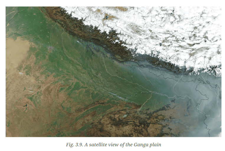
Ans:
→ The Ganga plain appears as a green expanse on the image, which shows its fertile land and vegetation.
→ The white expanse at the top shows the snow-covered Himalayan mountains, where high altitude keeps temperatures low and snow remains for long periods.
→ The brown expanse at the bottom left represents arid and semi-arid regions, such as parts of the Thar Desert, where there is less vegetation and more exposed soil.
Page 55
Q1. Can you give examples of river sources or confluences from your region that are regarded sacred by any community?
Ans: Yes. Examples of sacred river sources and confluences include:
- The Triveni Sangam at Prayagraj (Allahabad), where the Ganga, Yamuna and the mythical Saraswati meet. It is a very important pilgrimage site in Hinduism.
- The source of the Yamuna River at Yamunotri in Uttarakhand, which is visited by pilgrims and is a sacred place.
Q2. Visit a nearby river and observe all activities there, whether economic or cultural. Note them down and discuss with your classmates.
Ans: During a visit to the Yamuna River in Delhi the following activities were observed:
- Economic activities:
- Fishing by local people.
- Boating for transport or leisure.
- Vendors selling flowers and offerings to visitors.
- Washermen washing clothes along the riverbank.
- Cultural activities:
- People offering prayers and performing rituals on the riverbank.
- Floating diyas (lamps) during ceremonies.
- Immersion of idols during festivals.
- Morning yoga and meditation practised by local residents.
These activities show how a river supports both the local economy and cultural life.
Q3. Name some popular tourist destinations in India and identify the category of landform they are associated with.
Ans: Some popular Indian tourist places and their landforms:
- Agra (Taj Mahal): Located in the northern plains along the Yamuna River.
- Jaipur (Amber Fort): Found near the low hills of the Aravalli range.
- Goa (Beaches): Part of the coastal plains along the Arabian Sea.
- Shimla (Hill station): In the Himalayan mountains, known for its hilly terrain.
- Kerala (Backwaters): Lies in the coastal plains with lagoons and canals.
- Rajasthan (Thar Desert): An arid desert landform with sand dunes and sparse vegetation.
- Leh-Ladakh: In a high-altitude mountainous region of the Himalayas.
Questions, Activities and Projects
Q1. In what type of landform is your town/village/city located? Which features mentioned in this chapter do you see around you?
Ans: The landform of any place can be one of the following common types:
- Plains: Flat lands ideal for agriculture and settlements.
- Mountains: High and steep areas that affect climate and transport.
- Plateaus: Raised flatlands with steeper sides in places.
Local features you might observe include:
- Rivers: Flowing water bodies used for irrigation and other needs.
- Hills: Smaller elevations that can change local weather.
- Agricultural land: Fields and farms common in plains.
The exact features depend on the local geography and climate.
Q2. Let us go back to our initial trip from Chhota Nagpur to Prayagraj and Almora. Describe the three landforms you came across on the way.
Ans: On the journey from Chhota Nagpur to Prayagraj and Almora you pass through:
- Chhota Nagpur: A plateau known for rich mineral resources and somewhat undulating land.
- Prayagraj: Located in the fertile Ganga plain with wide flat lands suitable for farming.
- Almora: A mountainous area in the lower Himalayas with steep slopes and forested valleys.
Q3. List a few famous pilgrimage spots in India along with the landforms in which they are found.
Ans: Famous pilgrimage places and their landforms:
- Varanasi: In the plains along the Ganga River.
- Amarnath: In the high Himalayan mountains.
- Tirupati: Located in the hilly Eastern Ghats.
- Vaishno Devi: In the Trikuta Mountains of the Himalayas.
Q4. State whether true or false -
→ The Himalayas are young mountains with rounded tops.
Ans: False
Explanation: The Himalayas are young fold mountains but they mostly have sharp and rugged peaks rather than rounded tops because they are still being pushed up by tectonic forces and have not been worn down much by erosion.
→ Plateaus usually rise sharply at least on one side.
Ans: True
Explanation: Many plateaus have steep edges or escarpments on one or more sides where the land drops down to lower areas, so they often rise sharply on at least one side.
→ Mountains and hills belong to the same type of landform.
Ans: True
Explanation: Both mountains and hills are elevated landforms. The main difference is that hills are lower and less steep than mountains, but they belong to the same general category of high land.
→ Mountains, plateaus and rivers in India have the same types of flora and fauna.
Ans: False
Explanation: Different landforms have different climates and soils. Mountains, plateaus and river plains therefore support different plants and animals suited to those conditions.
→ Ganga is a tributary to the Yamuna.
Ans: False
Explanation: The Yamuna is a tributary of the Ganga. This means the Yamuna flows into the Ganga, not the other way around.
→ Deserts have unique flora and fauna.
Ans: True
Explanation: Deserts support plants and animals specially adapted to survive with little water and extreme temperatures, so their life forms are unique.
→ Melting snow feeds rivers.
Ans: True
Explanation: Snow and glacier melt in mountains add water to rivers, especially in spring and summer, helping to keep river flows steady.
→ Sediments from rivers deposited in the plains make the land fertile.
Ans: True
Explanation: When rivers slow down on the plains they drop fine soil called silt and other sediments. These materials enrich the soil and make plains very fertile for farming.
→ All deserts are hot.
Ans: False
Explanation: Not all deserts are hot. Some deserts, such as the Gobi or polar deserts, are cold. What makes a desert is low rainfall, not high temperature.
Q5. Match words in pairs:
| Column-A | Column-B |
|---|---|
| Mount Everest | Africa |
| Rafting | Roof of the world |
| Camels | Rice fields |
| Plateau | Desert |
| Gangetic Plains | River |
| Waterway | Ganga |
| Mount Kilimanjaro | Tributary |
| Yamuna | Climbing |
Ans:
| Column-A | Column-B |
|---|---|
| Mount Everest | Climbing |
| Rafting | River |
| Camels | Desert |
| Gangetic Plains | Rice fields |
| Waterway | Ganga |
| Yamuna | Tributary |
| Mount Kilimanjaro | Africa |
| Plateau | Roof of the world |
FAQs on NCERT Solutions: Landforms and Life
| 1. What are the main types of landforms and how do they affect where people live? |  |
| 2. How do mountains, plateaus, and plains differ in terms of height and formation? | |
| 3. Why do more people live on plains than mountains for CBSE Class 6 Social Studies? | |
| 4. What role do rivers play in shaping landforms and supporting life in different regions? | |
| 5. How do climate and weather patterns differ across mountains, plateaus, and plains in relation to their height? | |


