CBSE Class 6  >  Class 6 Notes  >  Social Studies  >  Worksheet: Locating Places on the Earth

Worksheet: Locating Places on the Earth

Multiple Choice Questions (MCQs)

Q1: What is a map primarily used for?
a) Showing where things are and how to get to them
b) Displaying random drawings
c) Creating confusion about directions
d) None of the above

Multiple Choice Questions (MCQs)

Q2: What is the purpose of a scale on a map?
a) To measure the weight of the map
b) To represent distances on the ground accurately
c) To confuse readers about distance
d) To decorate the map

Q3: What do the cardinal directions on a map represent?
a) Intermediate directions
b) Primary directions
c) Religious symbols
d) None of the above

Q4: What do symbols represent on a map?
a) Actual buildings and elements
b) Fictional characters
c) Random drawings
d) None of the above

Q5: What is the purpose of an atlas?
a) To confuse readers about geography
b) To provide a collection of maps
c) To display fictional locations
d) None of the above

Fill in the Blanks

Q1: A map is like a _________ guide.
Q2: Symbols on a map represent different kinds of __________.
Q3: The scale on a map helps in representing distances on the ________.
Q4: An atlas is a book or collection of ________.
Q5: Symbols are used on maps to represent features when there is limited space for ________.


True or False

Q1: Maps primarily show where things are and how to get to them. (True/False)
Q2: Symbols on a map do not represent any real elements. (True/False)
Q3: The scale on a map is not necessary for representing distances accurately. (True/False)
Q4: An atlas is a collection of maps. (True/False)
Q5: Symbols on a map are used to represent features when there is limited space. (True/False)
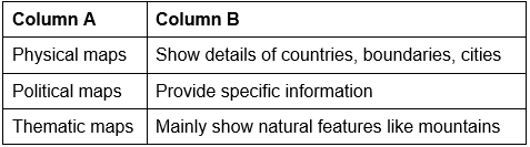
 

Match the Following

Match the Following

You can access the solutions to this worksheet here.

The document Worksheet: Locating Places on the Earth is a part of the Class 6 Course Social Studies for Class 6.
All you need of Class 6 at this link: Class 6

FAQs on Worksheet: Locating Places on the Earth

1. How do I use latitude and longitude to find a location on Earth?
Ans. Latitude measures distances north or south from the equator in degrees, while longitude measures distances east or west from the Prime Meridian. Together, these geographical coordinates form a grid system allowing precise identification of any place on Earth. The equator represents 0° latitude, and the Prime Meridian represents 0° longitude, dividing the planet into hemispheres for easy location mapping.
2. What's the difference between the equator and the Prime Meridian?
Ans. The equator is an imaginary line running horizontally around Earth's middle, dividing it into Northern and Southern hemispheres at 0° latitude. The Prime Meridian runs vertically through Greenwich, dividing Earth into Eastern and Western hemispheres at 0° longitude. Both are reference lines essential for the coordinate system used in locating places accurately on geographical maps and atlases.
3. Why do we need to learn about hemispheres and reference lines for finding places?
Ans. Hemispheres and reference lines create a standardised grid system enabling geographers, travellers, and navigators to pinpoint exact locations worldwide. Without these dividing lines-the equator, Prime Meridian, Tropics of Cancer and Capricorn-communicating geographical positions would be impossible. This system is fundamental in CBSE Class 6 Social Studies for understanding Earth's geography and developing map-reading skills essential for exams and real-world navigation.
4. How do parallels and meridians help in locating places on maps?
Ans. Parallels are horizontal lines representing latitude, running parallel to the equator at equal distances. Meridians are vertical lines representing longitude, converging at the poles. Together, they form a geographical grid enabling students to locate any position by identifying where parallels and meridians intersect. This network system is crucial for reading topographical maps and understanding spatial relationships across continents and oceans.
5. What are the main features I need to identify when reading a location map?
Ans. Key features include the scale (showing distance measurements), compass rose (indicating cardinal directions: North, South, East, West), latitude-longitude grid, and labelled geographical landmarks like cities, rivers, and borders. Students should also note the map's title and legend explaining symbols used. EduRev provides visual worksheets and flashcards helping Class 6 learners practise identifying these essential map components accurately during exam preparation.
Explore Courses for Class 6 exam
Get EduRev Notes directly in your Google search
Related Searches
Summary, Sample Paper, Viva Questions, study material, Important questions, past year papers, Worksheet: Locating Places on the Earth, Objective type Questions, pdf , Worksheet: Locating Places on the Earth, Worksheet: Locating Places on the Earth, shortcuts and tricks, Semester Notes, Exam, ppt, Free, Extra Questions, MCQs, Previous Year Questions with Solutions, video lectures, practice quizzes, mock tests for examination;