Worksheet Solutions: Oceans and Continents

Multiple Choice Questions (MCQs)
Q1: What is the largest continent on Earth?
(a) Africa
(b) Asia
(c) North America
(d) Antarctica
Ans: (b) Asia
Q2: Which ocean is the smallest?
(a) Indian Ocean
(b) Arctic Ocean
(c) Atlantic Ocean
(d) Pacific Ocean
Ans: (b) Arctic Ocean
Q3: What is the main reason for seawater being salty?
(a) Fish excretion
(b) River runoff of salt
(c) Underground springs
(d) Evaporation
Ans: (b) River runoff of salt
Q4: How many major oceans are there?
(a) Three
(b) Five
(c) Seven
(d) Four
Ans: (b) Five
Q5: What is the term for large, powerful waves caused by underwater earthquakes?
(a) Cyclones
(b) Tsunamis
(c) Tides
(d) Storm surges
Ans: (b) Tsunamis
Fill in the Blanks
Q1: The __________ Ocean is the largest ocean on Earth.
Ans: Pacific
Q2: The __________ is a massive wave typically caused by an earthquake.
Ans: Tsunami
Q3: __________ is the process by which water vapor turns into liquid water.
Ans: Condensation
Q4: The Indian Navy's motto is "Sam noh __________."
Ans: Varunah
Q5: The __________ Hemisphere has more land than the Southern Hemisphere.
Ans: Northern
True or False
Q1: The Southern Hemisphere has more land than the Northern Hemisphere.
Ans: False
Q2: Freshwater is more abundant than seawater on Earth.
Ans: False
Q3: Oceans produce more than half of the world's oxygen.
Ans: True
Q4: Greenland is the largest continent in the world.
Ans: False
Q5: The Arabian Sea is located to the east of India.
Ans: False
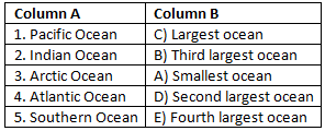
Match the Following
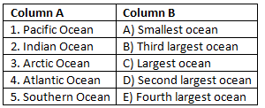 Ans:
Ans:
FAQs on Worksheet Solutions: Oceans and Continents
| 1. What are the seven continents and how do I remember them for my Class 6 exam? |  |
| 2. How are oceans different from seas, and what are the five major oceans? | |
| 3. Why do continents and oceans matter for geography studies in Class 6? | |
| 4. What's the difference between a continent and an island, and can I get examples for worksheet solutions? | |
| 5. How do I identify oceans and continents on a world map using latitude and longitude lines? | |


