Worksheet Solutions: Landforms and Life

Multiple Choice Questions (MCQs)
Q1: What is a landform?
(a) A type of tree
(b) A natural feature on the Earth's surface
(c) A man-made structure
(d) A type of animal
Ans: (b)
Explanation: A landform is a natural feature of the Earth's surface. Examples include mountains, valleys, plains and plateaus. These features are formed by natural processes like erosion, deposition and tectonic activity.
Q2: Which mountain is known as the highest peak in the Himalayas?
(a) Kanchenjunga
(b) Mount Kilimanjaro
(c) Mount Everest
(d) Mont Blanc
Ans: (c)
Explanation: Mount Everest is the highest peak in the Himalayas and on Earth. It rises to an altitude of about 8,848 m above sea level, which makes it higher than other Himalayan peaks like Kanchenjunga.
Q3: What type of farming is commonly practiced in mountainous regions?
(a) Terrace farming
(b) Aquaculture
(c) Urban farming
(d) Hydroponics
Ans: (a)
Explanation: Terrace farming is used on steep slopes. Farmers cut the slope into a series of flat steps or terraces. This reduces soil erosion and makes it possible to grow crops on otherwise steep land.
Q4: Which of the following is a characteristic of plateaus?
(a) They are always covered with snow
(b) They have a flat top
(c) They are lower than the surrounding land
(d) They are formed by erosion
Ans: (b)
Explanation: A plateau is an area of high land with a relatively flat top. Plateaus are higher than the surrounding land and may be formed by uplift or volcanic activity.
Q5: What is the Tibetan Plateau commonly referred to as?
(a) The Roof of the World
(b) The Valley of the Gods
(c) The Desert of the East
(d) The Mountain Range
Ans: (a)
Explanation: The Tibetan Plateau is often called "The Roof of the World" because it is the highest and one of the largest plateaus on Earth, with very high average elevation.
Fill in the Blanks
Q1: A __________ is a natural feature on the Earth's surface, such as mountains or plains.
Ans: landform
Q2: The __________ is the highest mountain in South America.
Ans: Mount Aconcagua
Q3: __________ farming is practiced on steep slopes by cutting steps into the land.
Ans: Terrace
Q4: The __________ Plateau is known for its rich mineral resources.
Ans: Chhota Nagpur
Q5: The __________ is a large area of flat or gently rolling land.
Ans: plain
True or False
Q1: Mountains are always covered with snow.
Ans: False
Explanation: Not all mountains are covered with snow. Only mountains that are very high or located in cold regions have permanent snow. Lower mountains or those in warmer climates may not have snow.
Q2: The Himalayas are considered young mountains because they formed recently in Earth's history.
Ans: True
Explanation: The Himalayas are called young mountains because they were formed more recently by the collision of tectonic plates and are still rising. Young mountains tend to be higher and more rugged.
Q3: The Tibetan Plateau is the largest and highest plateau in the world.
Ans: True
Explanation: The Tibetan Plateau is both very large and has a very high average elevation, which is why it is described as the largest and highest plateau.
Q4: Floodplains are formed by the deposition of sediments by rivers.
Ans: True
Explanation: Floodplains form when rivers flood and deposit silt and other sediments on the surrounding low-lying land. Over time, these deposits build up to create flat, fertile plains.
Q5: The term 'avalanches' refers to the sudden fall of rocks from a mountainside.
Ans: False
Explanation: An avalanche usually means a sudden flow of snow, ice and sometimes rocks down a slope. The sudden fall of rocks alone is usually called a rockfall or landslide.
Match the Following
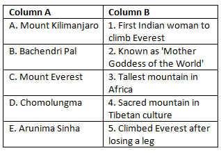
Ans: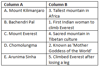
FAQs on Worksheet Solutions: Landforms and Life
| 1. How do mountains and plains affect where people live and build cities? |  |
| 2. What's the difference between a plateau and a mountain in terms of landforms? | |
| 3. Why do rivers flow through valleys and how does this shape the land around them? | |
| 4. What landforms are created by coastal areas and how do they support life? | |
| 5. How do different landforms like deserts, forests, and grasslands support different types of life and human activities? | |


