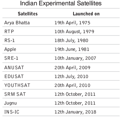
Some Early Satellites


Introduction
India's space exploration journey began in the 1970s, spearheaded by the Indian Space Research Organisation (ISRO). The country's efforts have evolved over the decades, starting with early satellite launches to developing sophisticated launch vehicles and regional navigational systems.
Early Satellites
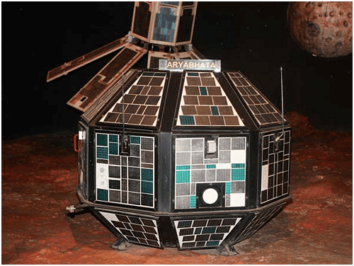
- Aryabhatta: Launched on April 19, 1975, by the Soviet Union from Kapustin Yar using a Cosmos-3M launch vehicle, Aryabhatta was India's first satellite. It was built by ISRO to gain expertise in satellite construction and operations in space.
- Bhaskara: The Bhaskara I and II satellites were India's first low Earth orbit Earth Observation Satellites, built by ISRO. These satellites were designed to collect data for various remote sensing applications.
- Rohini: The Rohini series included four satellites-Rohini Technology Payload (RTP), RS-1, RS-D1, and RS-D2. Launched using ISRO's Satellite Launch Vehicle (SLV) between 1980 and 1994, three of these satellites successfully reached orbit. These were mainly experimental, testing the capabilities of the SLV.
- Experimental Satellites: ISRO has launched numerous small satellites for experimental purposes, focusing on areas like remote sensing, atmospheric studies, payload development, orbit control, and recovery technology.
Launch Vehicles Programmes
Launch vehicles are critical for transporting and deploying satellites or spacecraft into space. India's development of launch vehicles began in the early 1970s.
Generations of Launch Vehicles
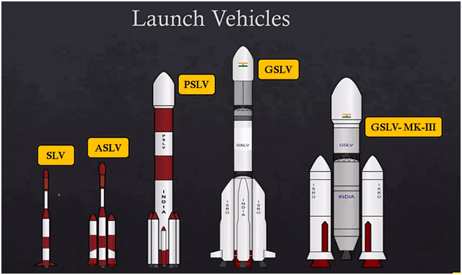
- SLV (Space Launch Vehicle): The first generation of India's launch vehicles, SLV-3, was an experimental satellite launch vehicle. On July 18, 1980, it successfully placed the Rohini Satellite RS-I into orbit, marking a significant milestone for India's space program.
- ASLV (Augmented Satellite Launch Vehicle): ASLV was the second generation launch vehicle developed to be a low-cost, intermediate vehicle. It was aimed at testing and validating critical technologies. The first successful ASLV launch, ASLV-D3, occurred on May 20, 1992.
- PSLV (Polar Satellite Launch Vehicle): PSLV represents ISRO's first operational launch vehicle, which became active in 1982. This third-generation vehicle is a four-stage rocket using alternating solid and liquid propulsion systems. PSLV is designed to launch satellites into low Earth orbits, and its modifications have even enabled it to place satellites into geostationary orbits. The development of PSLV faced opposition from Western countries due to its potential intercontinental ballistic missile (ICBM) capabilities.
- GSLV (Geosynchronous Satellite Launch Vehicle): GSLV is a launch system operated by ISRO, developed to launch India's INSAT-type satellites into geostationary orbit, reducing dependence on foreign rockets. All GSLV launches are conducted from the Satish Dhawan Space Centre in Sriharikota.
- GSLV Mark II: This variant of the GSLV uses an Indian cryogenic engine and can launch payloads of up to 2500 kg into geostationary transfer orbit.
- GSLV Mark III: The heaviest launch vehicle developed by ISRO, GSLV Mark III, is a three-stage vehicle with a height of 42.4 meters and a lift-off weight of 630 tonnes. It is capable of launching communication satellites weighing up to 4 tonnes.
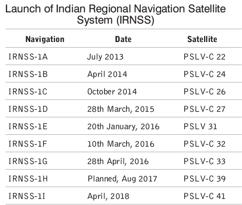
Indian Regional Navigational Satellite System (IRNSS)
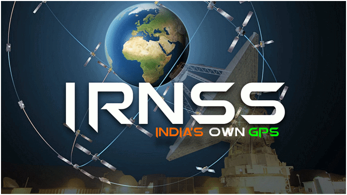
IRNSS is an independent regional navigation satellite system designed to provide position accuracy better than 10 meters over India and its surrounding region up to 1500 km. The system offers real-time Position, Navigation, and Time (PNT) services, operational 24/7 under all weather conditions. The IRNSS constellation consists of seven satellites, with software developed indigenously by ISRO. IRNSS provides two services: the Standard Positioning Service, available to all users, and the Restricted Service, an encrypted service for authorized users only.
International Navigational Systems
- Global Positioning System (GPS): Managed by the U.S. Department of Defense, GPS is widely used for navigation, mapping, land surveying, and various commercial and scientific purposes.
- Glonass: A Russian satellite-based navigation system that provides real-time position and velocity data.
- Galileo: Operated by the European Union and the European Space Agency, Galileo is a global navigation satellite system.
- BeiDou: China's satellite navigation system, with 22 operational satellites in orbit. The BeiDou-3 constellation was fully completed by June 23, 2020.
GAGAN (GPS Aided GEO Augmented Navigation)
GAGAN is a satellite-based augmentation system developed in collaboration with the Airports Authority of India (AAI). Its main objectives are to provide accurate satellite-based navigation services for civil aviation and improve air traffic management over Indian airspace.
Geographical Information System (GIS)
A GIS is a computer-based tool for mapping and analyzing spatial data. It integrates common database operations like query and statistical analysis with the visual and geographic analysis benefits of maps.
Application of GIS
- Business: Used for target marketing, competitive analysis, demographic analysis, risk management, route planning, and expansion analysis.
- Healthcare: Applied in marketing, research and planning, facilities management, and finance.
- Government: Utilized for economic development, legislative reforms, voter registration, and land use control.
- Agriculture: Employed for production analysis, precision farming, regulatory compliance, and financial modeling.
- Education: Used for administration, school district mapping, and student assignment.
- Telecommunication: Used for market targeting, wireless engineering, customer support, and outside plant engineering.
- Petroleum: Applied in retail distribution, facilities management, and exploration.
- Environment Management: Used for site remediation, natural resource management, waste management, water quality, and groundwater modeling, as well as vegetation mapping.
- Public Safety: Supports emergency response mechanisms, providing real-time emergency response capabilities.
FAQs on Some Early Satellites
| 1. What is the Indian Regional Navigational Satellite System (IRNSS)? |  |
| 2. What is GAGAN and how does it work? | |
| 3. How does the Geographical Information System (GIS) play a role in satellite technology? | |
| 4. What are some of the early satellites launched by India? | |
| 5. How has the Launch Vehicles Programmes in India evolved over the years? | |