Class 6 Social Science: Sample Paper Solutions - 4

Time: 3 hrs
Total Marks: 80
General Instructions:
- The question paper consists of 34 questions and is divided into four sections: A, B, C, and D.
- All questions are compulsory.
- Section A comprises question numbers 1 to 15. These are multiple-choice questions carrying one mark each. You are to select one most appropriate response out of the four provided options.
- Section B comprises question numbers 16 to 22. These are short-answer questions carrying two marks each.
- Section C comprises question numbers 23 to 31. These are short-answer questions carrying four marks each.
- Section D comprises question numbers 32 to 34. These are short-answer questions carrying five marks each.
Section A
Q1: If a map's scale shows 1 cm equals 500 km, and two points on the map are 3.5 cm apart, what is the real distance between them? (1 Mark)
(a) 1,500 km
(b) 1,750 km
(c) 2,000 km
(d) 2,500 km
Ans: (b)
Explanation: Multiply the map distance by the scale: 3.5 cm × 500 km/cm = 1,750 km. Hence option (b) is correct.
Q2: What is the primary reason oceans are not truly separate despite being named individually? (1 Mark)
(a) Seawater flows freely across their boundaries
(b) Marine life migrates between them constantly
(c) They share the same climate patterns
(d) Human conventions blur their natural divisions
Ans: (a)
Explanation: Oceans are connected bodies of water; currents and tides allow seawater to move from one named ocean to another. This physical connection, not merely migration or naming, makes them one continuous global ocean.
Q3: What metal did the Harappans mix with copper for tools? (1 Mark)
(a) Iron
(b) Tin
(c) Gold
(d) Silver
Ans: (b)
Explanation: Harappans alloyed copper with tin to make bronze. Bronze is harder and more durable than pure copper, so mixing with tin improved tools and weapons before iron became common.
Q4: What is the significance of the Vedic mantra "ekam sat vipra bahudhā vadanti" in understanding early Indian beliefs? (1 Mark)
(a) It emphasizes the worship of multiple gods over a single deity
(b) It suggests that truth is one but expressed in many ways
(c) It promotes the separation of human life from cosmic order
(d) It denies the existence of divine essence in nature
Ans: (b)
Explanation: The Rig Vedic line means "Truth is one; sages describe it in many ways." It shows an early belief in a single reality seen and named differently by different people, emphasising unity beneath diversity.
Q5: What are wards in the context of urban local governance? (1 Mark)
(a) Military divisions
(b) Rural administrative units
(c) Divisions within cities for better governance
(d) National electoral divisions
Ans: (c)
Explanation: Wards are parts of a city divided for local governance. Each ward elects representatives who look after local services, making city administration more manageable and responsive.
Q6: Why do parallels of latitude decrease in size as you move from the Equator toward the poles? (1 Mark)
(a) The Earth's rotation compresses them near the poles
(b) They are imaginary circles that get smaller on a spherical surface
(c) Longitude lines shorten them as they converge
(d) The climate zones shrink them toward the poles
Ans: (b)
Explanation: On a spherical Earth, circles of latitude are largest at the Equator and become smaller toward the poles. This is a geometric result of drawing horizontal circles on a globe, not caused by rotation or climate.
Q7: Which expert studies fossils to uncover the history of plants, animals, and humans from millions of years ago? (1 Mark)
(a) Geologist
(b) Palaeontologist
(c) Anthropologist
(d) Archaeologist
Ans: (b)
Explanation: A palaeontologist studies fossils to learn about long-past life forms. Geologists study rocks, anthropologists study humans and cultures, and archaeologists study material remains of past human societies.
Q8: What significant impact have Sarpanchs had on local governance? (1 Mark)
(a) No impact on governance
(b) Improved local infrastructure and community projects
(c) Only managed cultural festivals
(d) Decreased community involvement
Ans: (b)
Explanation: Sarpanchs, as elected heads of Gram Panchayats, have led improvements in local infrastructure (roads, water supply) and community projects, increasing participation and development at the village level.
Q9: How do tribal traditions, such as those of the Todas in the Nilgiris, demonstrate a belief similar to Hinduism? (1 Mark)
(a) They reject all forms of divinity
(b) They view natural elements as sacred and linked to a supreme being
(c) They focus solely on material wealth and possessions
(d) They deny the interdependence of living creatures
Ans: (b)
Explanation: Like some Hindu traditions, the Todas regard natural features (hills, rivers) as sacred and believe these are connected to a higher power. This reverence for nature reflects similar spiritual ideas.
Q10: Why might historians find contradictory information when reconstructing the past? (1 Mark)
(a) Sources like inscriptions and genetics always align perfectly
(b) Different sources, such as artifacts and texts, may not agree, requiring judgment
(c) Early humans left no reliable records
(d) Timelines erase conflicting events over time
Ans: (b)
Explanation: Historians use many sources-texts, inscriptions, artefacts, genetics-that sometimes give different accounts. Such contradictions require careful interpretation and judgement to build a balanced picture of the past.
Q11: What role do feelings play in non-economic activities? (1 Mark)
(a) They decrease the importance of these activities
(b) They lead to financial profit
(c) They motivate actions out of gratitude, love, or duty
(d) They are irrelevant in non-economic decisions
Ans: (c)
Explanation: Non-economic activities-such as caring for family or helping neighbours-are often driven by emotions like love, gratitude or a sense of duty, not by profit.
Q12: Which plateau is known as the "Roof of the World" due to its average altitude of 4,500 meters? (1 Mark)
(a) Deccan Plateau
(b) Chhota Nagpur Plateau
(c) Tibetan Plateau
(d) East African Plateau
Ans: (c)
Explanation: The Tibetan Plateau averages about 4,500 m above sea level and is commonly called the "Roof of the World" because of its very high altitude.
Q13: What natural boundaries define "Bhārata" as described in an ancient text as lying north of the ocean and south of the snowy mountains? (1 Mark)
(a) The Arabian Sea and the Himalayas
(b) The Bay of Bengal and the Deccan Plateau
(c) The Indus River and the Thar Desert
(d) The Ganga River and the Vindhya Range
Ans: (a)
Explanation: Ancient descriptions place Bhārata between the great southern seas (for example, the Arabian Sea and Bay of Bengal) and the snowy Himalayas to the north, so option (a) best matches this idea.
Q14: What would likely happen if there were no rules in society? (1 Mark)
(a) Increased freedom for all
(b) No significant change
(c) Disorder and inability to function smoothly
(d) More efficient governmental operations
Ans: (c)
Explanation: Rules provide order and predictable behaviour. Without them, daily life and public services would face confusion and conflict, making society unable to function smoothly.
Q15: In ancient Tamil Sangam poetry, which landscape is associated with hunting and gathering as the main occupation? (1 Mark)
(a) Mullai
(b) Kurinji
(c) Marudam
(d) Palai
Ans: (b)
Explanation: Kurinji refers to hilly regions in Sangam poetry and is linked with hunting and gathering as the main occupation, unlike other landscapes associated with farming or pastoral life.
Section B
Q16: Why are meridians semicircle? (2 Marks)
Ans: Meridians are semicircles because each one runs from the North Pole to the South Pole. On a globe they form half-circles that link the poles and measure east-west positions in degrees from the Prime Meridian. Their curved shape reflects the Earth's roundness and helps locate places such as Delhi (around 77°E).
Q17: How does Europe's shape affect it? (2 Marks)
Ans: Europe's jagged coastline with many peninsulas and bays increased access to the sea. This encouraged trade, fishing and contact with other regions, helping cities and ports grow rich. For example, Mediterranean ports linked Europe with Asia and Africa, shaping its history and economy.
Q18: How do plateaus store minerals? (2 Marks)
Ans: Plateaus often expose old rock layers that contain concentrated minerals like coal and iron. Over long geological time, mineral-bearing rocks were pushed up or formed there, and later mining recovers these resources. The Deccan Plateau, for instance, contains mineral deposits that are worked for industry.
Q19: Why are tools prehistory's key clues? (2 Marks)
Ans: Tools are direct physical evidence
Q20: Why is the Arabian Sea vital? (2 Marks)
Ans: The Arabian Sea is important for trade and fishing along India's west coast, linking ports like Mumbai with Arabia and East Africa. It also brings monsoon winds that help irrigate crops in coastal states and supports the livelihoods of millions of fishermen.
Q21: How did Harappans store water? (2 Marks)
Ans: Harappans stored water in deep wells and tanks lined with baked bricks, which reached groundwater and retained water during dry seasons. Large, well-planned wells (some over 10 metres deep) found in Mohenjo-Daro show their advanced water management and ability to support large urban populations.
Q22: What does the Arthashastra reveal? (2 Marks)
Ans: The Arthashastra, attributed to Chanakya, explains ideas of statecraft such as taxation, administration, defending the kingdom and even using intelligence systems. It gives practical advice to rulers on managing economy, law and security, showing organised political thinking in ancient India.
Section C
Q23: (i) What are parallels of latitude?
(ii) How do they differ from meridians? (4 Marks)
Ans: (i) Parallels of latitude are imaginary horizontal circles around the Earth, such as the Equator (0°), used to measure how far north or south a place lies.
(ii) They differ from meridians, which are vertical semicircles running from pole to pole and measure east-west position. Parallels remain parallel and do not meet; meridians meet at the poles. Together they give the grid to locate any place, for example Delhi at about 28°N, 77°E.
Q24: (i) What is a peninsula?
(ii) Name one in India. (4 Marks)
Ans: (i) A peninsula is a piece of land surrounded by water on three sides but connected to the mainland on one side.
(ii) The Deccan Peninsula is an example in India, extending into the Indian Ocean with the Arabian Sea to the west and the Bay of Bengal to the east.
Q25: (i) How do deserts challenge life?
(ii) Name one desert activity in India. (4 Marks)
Ans: (i) Deserts make life hard because of scarcity of water, very hot days and cold nights, and poor soil, all of which make farming and settlement difficult.
(ii) In the Thar Desert, camel trading and camel transport are important activities; camels help move goods and people where wheeled vehicles struggle.
Q26: (i) What are sculptures as sources?
(ii) Give an Indian example. (4 Marks)
Ans: (i) Sculptures are carved or cast figures and objects that show artistic skill, religious beliefs and social values of past peoples; they provide visual information about dress, worship and rulers.
(ii) The Ashoka Pillar at Sarnath, with its four lions, is a famous example. It tells us about Emperor Ashoka's rule, artistic skill and links to Buddhist ideas.
Q27: (i) What is the Eastern Ghats' role?
(ii) How does it differ from the Western Ghats? (4 Marks)
Ans: (i) The Eastern Ghats are a range of low hills along India's east coast that support forests and guide rivers such as the Godavari and the Krishna towards the Bay of Bengal.
(ii) They differ from the Western Ghats, which are higher and receive heavier rainfall, creating lush forests on the west coast, while the Eastern Ghats are lower and receive less rain, so the regions behind them are drier.
Q28: (i) What were Harappan toys like?
(ii) What do they tell us? (4 Marks)
Ans: (i) Harappan toys included small clay animals, terracotta dolls and wheeled carts, made with care and detail.
(ii) These toys show that people had time for play and skill in craftsmanship. Wheeled toys also indicate knowledge of transport. Together they suggest a settled society with leisure and skilled artisans.
Q29: (i) What are the Puranas?
(ii) How do they shape stories? (4 Marks)
Ans: (i) The Puranas are a group of ancient Indian texts composed after the Vedas; they contain myths, legends of gods and kings, and religious teachings.
(ii) They shaped stories by providing popular tales-such as the deeds of Vishnu and Shiva-that taught moral lessons and formed the basis of festivals and cultural traditions still celebrated today.
Q30: (i) How do languages unite India?
(ii) Name one language from the south. (4 Marks)
Ans: (i) Languages unite India by carrying literature, ideas and shared cultural values; many Indian languages borrow from common roots like Sanskrit and people often learn other languages, aiding communication across regions.
(ii) Tamil is an important southern language with a long literary tradition, widely spoken in Tamil Nadu.
Q31: What are some of the rules you follow in your family and neighbourhood? Why are they important? (4 Marks)
Ans: Some general rules I follow are:
I. In the Family:
(a) Respectful communication: Speak kindly and listen to each other.
(b) Chores and responsibilities: Share household tasks to learn responsibility and time management.
(c) Curfews and screen-time limits: Maintain healthy sleep and study habits.
(d) Honesty: Build trust by being truthful.
II. In the Neighbourhood:
(a) Respect property: Do not damage others' belongings and keep surroundings clean.
(b) Keep noise low: Maintain peace and respect others' rest.
These rules are important because they create order, promote safety and teach responsibility, helping everyone live together peacefully.
Section D
Q32: What is the Zila Parishad's role? How does it support rural areas? (5 Marks)
Ans:
- The Zila Parishad is the district-level local government body placed above Panchayat Samitis and is composed of elected members.
- It plans and implements larger development projects for the district such as district hospitals, main roads and major irrigation works.
- It prepares and approves district budgets, allocates funds to blocks and monitors how resources are used.
- It listens to block-level needs (for example more teachers or health services) and distributes government grants so villages receive support fairly.
- It can set up district training centres, build clinics or help construct irrigation structures, tasks that individual villages may not manage alone.
- By coordinating between state governments and village bodies, the Zila Parishad ensures that development reaches all parts of a district, improving education, health and livelihoods.
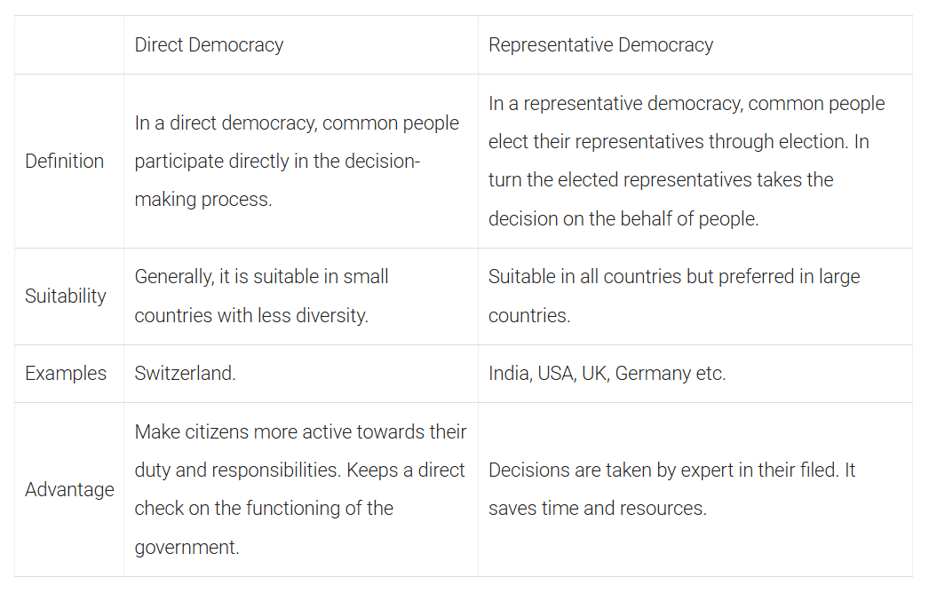
Q33: What is the meaning of democracy? What is the difference between direct democracy and representative democracy? (5 Marks)
Ans: Democracy is a system of government in which people choose their rulers and take part in decision making. The word comes from Greek: demos meaning 'people' and kratos meaning 'rule' or 'power'.
Direct democracy: People take part directly in decisions. Citizens vote on laws or policies themselves in meetings or referendums. This form suits small communities where it is possible for everyone to meet and decide.
Representative democracy: People elect representatives to make decisions on their behalf. Representatives meet in assemblies or parliaments and decide for the whole community. This is practical for large countries; for example, India follows representative democracy where citizens elect leaders to govern.
In short, the main difference is that direct democracy involves direct participation by all citizens, while representative democracy works through elected persons who act for the people.
Q34: During October-November, many major festivals take place in India. Make a list of the few main ones and their various names in different parts of the country. (5 Marks)
Ans: October-November is a festive season in India. A few main festivals and their regional names are:
1. Diwali (Deepavali) - North India: Diwali; South India: Deepavali; Maharashtra: Diwali; Bengal: Kali Puja / Shyama Puja.
2. Dussehra (Vijayadashami) - North India: Dussehra; Karnataka: Dasara; West Bengal: concludes as Durga Puja; Andhra Pradesh and Telangana: Vijaya Dashami; Maharashtra: Dasara.
3. Navratri - Celebrated across India: Gujarat: Navratri with Garba and Dandiya; West Bengal: forms part of Durga Puja; South India: displays such as Bommai Golu or Gombe Habba in Tamil Nadu.
4. Bhai Dooj (Bhaiya Dooj) - North India: Bhai Dooj / Bhaiya Dooj; Bengal: Bhai Phonta; Maharashtra: Bhau Beej; Gujarat: Bhai Beej.
5. Chhath Puja - Mainly Bihar, Jharkhand and eastern Uttar Pradesh: called Chhath, worshipping the Sun; also observed by migrant communities elsewhere.
6. Govardhan Puja / Annakut - North India: Govardhan Puja; in Gujarat and Maharashtra it is celebrated as Annakut with offerings of many cooked items.
These festivals show regional variations in name and customs but share themes of devotion, family gatherings and community celebration, reflecting India's cultural diversity and unity.
FAQs on Class 6 Social Science: Sample Paper Solutions - 4
| 1. What are the main topics covered in Class 6 Social Science? |  |
| 2. How can I prepare effectively for my Class 6 Social Science exam? | |
| 3. What types of questions can I expect in my Class 6 Social Science exam? | |
| 4. How important is map work in Class 6 Social Science? | |
| 5. Are there any specific study resources recommended for Class 6 Social Science? | |


