NCERT Solutions: Geographical Diversity of India

The Big Question (Page 1)
Q1: What are some key geographical features of India?Ans: The key geographical features of India are:
- India has many types of landforms like mountains, plains, deserts, plateaus, coasts, and islands.
- The Himalayas in the north are tall mountains that protect India and give rise to important rivers.
- The Gangetic Plains are flat and fertile, ideal for growing crops and supporting large populations.
- Other major features include the Thar Desert, the Deccan Plateau, and long coastlines with many islands.
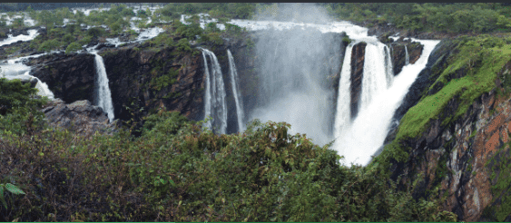 Jog Falls in Karnataka
Q2: How does India's geographical diversity affect our lives?
Ans: India's geographical diversity affect our lives by following ways:
- People wear different clothes, eat different food, and celebrate different festivals based on the region they live in.
- Geography affects farming, trade, and transport-plains are good for crops, and coasts help in fishing and shipping.
- People in deserts, mountains, and forests adapt their lifestyles to survive in their environment.
- The variety of landscapes supports rich biodiversity, tourism, and natural resources like water, minerals, and forests.
Back Questions (Page 24 & 25)
Q1: What, in your opinion, are two important geographical features of India? Why do you think they are important?Ans:Two important geographical features of India are:
The Himalayas: The Himalayan mountain range is one of the most significant geographical features in India. It forms a natural boundary between India and the countries to its north, such as China and Nepal. The Himalayas are important because they influence the climate of India, as they block the cold winds from the north, creating a warmer climate in the plains. They also feed major rivers, like the Ganga and the Brahmaputra, which are crucial for agriculture and daily life. Additionally, the Himalayas are home to various species of plants and animals, making them an ecological hotspot.
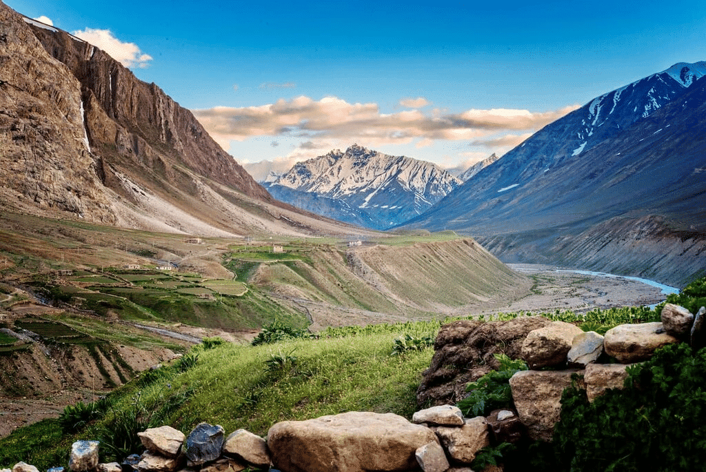
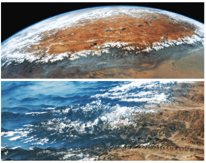 Satellite Image of Himalayan Range
The Gangetic Plains: The Gangetic Plains, located in the northern part of India, are known for their fertile soil, which is enriched by the Ganga and its tributaries. This feature is crucial because it supports the majority of India's population due to its fertile land, which is ideal for agriculture. The region is the breadbasket of India, growing crops such as rice, wheat, and sugarcane. The rivers that flow through this region are also used for irrigation and transport.
Q2: What do you think India might have looked like if the Himalayas did not exist? Write a short note or sketch a drawing to express your imagination.
Ans:
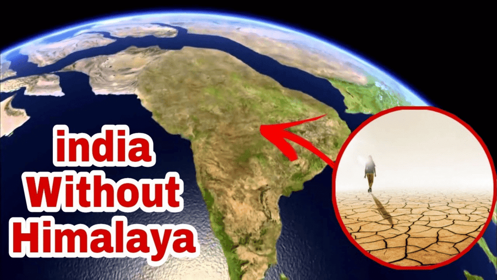
- If the Himalayas did not exist, India would have a very different landscape. The northern regions, which are currently protected by the Himalayas from the cold winds from Central Asia, would experience much colder temperatures.
- The absence of the Himalayas would likely lead to a loss of the snow-fed rivers like the Ganga, which are essential for agriculture. Additionally, the absence of the mountains would mean a lack of the scenic beauty and natural barriers that have helped preserve India's unique biodiversity.
- The north of India could be more prone to extreme cold conditions, and the cultural significance of the Himalayas as a sacred and spiritual place would be lost.
- In terms of landforms, India might have been more like a flat or rolling plateau without the high mountain ranges. This might also have impacted the flow of the major rivers, altering their course and effect on agriculture.
Q3: India has been called a 'mini-continent'. Based on what you've read, why do you think this is so?
Ans: India is called a 'mini-continent' because of its vast geographical diversity. It has all types of landforms, including mountains, plateaus, deserts, and coastlines, which are usually found across different continents. For example:
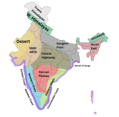 Geographic Regions of India
- The Himalayas in the north represent high mountain ranges, similar to the ones found in other parts of the world, like the Alps in Europe.
- The Thar Desert in the west is similar to deserts found in Africa and the Middle East.
- The Gangetic Plains provide fertile land for agriculture, much like the plains of other river systems around the world.
- The peninsular plateau in the south resembles regions of central Africa or South America.
This diversity in geographical features, climate, flora, and fauna, along with the vast range of cultures and languages, makes India resemble a continent on its own.
Q4: Follow one of India's big rivers from where it starts to where it meets the ocean. What are the different ways in which people might utilize this river along its journey? Discuss in groups in your class.
Ans: Let's take the Ganga River as an example:
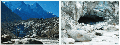 Gaumukh
- Source: The Ganga starts from the Gaumukh glacier in the Himalayas, where the snow melts to form the river. It is the source of water for millions of people.
- In the Hills: As the Ganga flows through the Himalayas, it is used for drinking, irrigation, and as a source of hydroelectric power.
- In the Plains: As the Ganga enters the plains, it becomes the lifeline of agriculture for the region, providing water for irrigation. It is also used for transport by boat, especially in areas with no road infrastructure. Additionally, the river has been historically important for trade.
- Cultural Significance: The Ganga is considered sacred, and it attracts millions of pilgrims who bathe in its waters to wash away sins.
- Mouth of the River (Delta): When the Ganga reaches the Bay of Bengal, it forms a delta, and the river is used for fishing, transport, and supporting the local economy through agriculture.
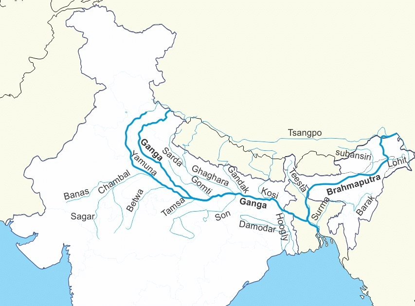 Ganga River
Q5: Why is the southern part of India referred to as a peninsular plateau?
Ans:
- The southern part of India is referred to as a peninsular plateau because it is a large, triangular landmass that is elevated above the surrounding areas and is surrounded by water on three sides.
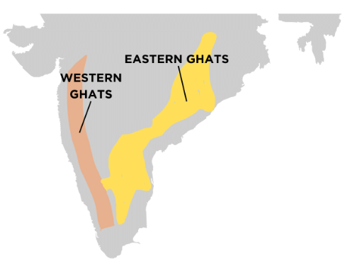 Peninsular Plateau
- This plateau is bordered by the Western Ghats and Eastern Ghats and is also known as the Deccan Plateau. Being a plateau, the land is generally flat and raised, making it an important area for mining, agriculture, and various industries.
- The plateau also has a significant number of rivers that flow across it, providing water for irrigation and power generation.
Q6: Which UNESCO Heritage Site mentioned in this chapter did you find more interesting? Write a short paragraph to describe what about it is interesting.
Ans:
- One of the UNESCO World Heritage Sites mentioned in this chapter that I find interesting is the Great Himalayan National Park in Himachal Pradesh.
- This park is rich in biodiversity and is home to a wide variety of plants and animals, many of which are rare or endangered. The park is also significant for its role in preserving the unique ecosystem of the Himalayas.
- It provides a natural habitat for species like the snow leopard, Himalayan monal, and several types of rhododendrons.
- The park's conservation efforts are a great example of how local communities work alongside the government to protect natural habitats, making it a fascinating place for both nature lovers and conservationists.
Q7: Look at the two maps of India, physical as well as political, given at the end of this book. Identify the place you are at now. Which physical feature of India would you use to describe its location?
Ans: Based on the physical map of India, the place I am located at is [insert location here]. The physical feature I would use to describe its location would depend on the landform near me. For example:
- If I am in the north, I would say that I am near the Himalayas, which forms a natural barrier to the north.
- If I am in the west, I could say that I am near the Thar Desert.
- If I am in the south, I might say I am near the Peninsular Plateau and surrounded by water on three sides, forming a peninsula.
Q8: Food preservation techniques differ from place to place across India. They are adapted to local conditions. Do a class project. Gather different methods of preserving food. Hint: Drying vegetables when they are in season for use during the off-season.
Ans: Food preservation techniques in India vary based on climate and available resources. Some examples include:
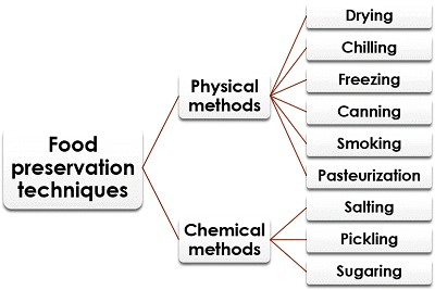
- Drying: In many parts of India, people dry vegetables and fruits like mangoes, tomatoes, and carrots to preserve them for off-season use. This method is commonly used in rural areas, especially in dry and hot climates.
- Pickling: In regions like Rajasthan and Gujarat, pickling is a common method to preserve fruits and vegetables such as mangoes, lemons, and carrots. These are preserved with spices and oils.
- Salting and Smoking: In coastal regions, fish and meat are preserved by salting and smoking to keep them for longer periods.
- Canning and Jarring: In urban areas, modern methods like canning and jarring are also used to preserve fruits and vegetables.
Q9: Despite having such different regions (mountains, deserts, plains, coasts), India remains one country. How do you think our geography has helped unite people?
Ans: India's geography, despite its vast diversity, has played a significant role in uniting people in several ways:
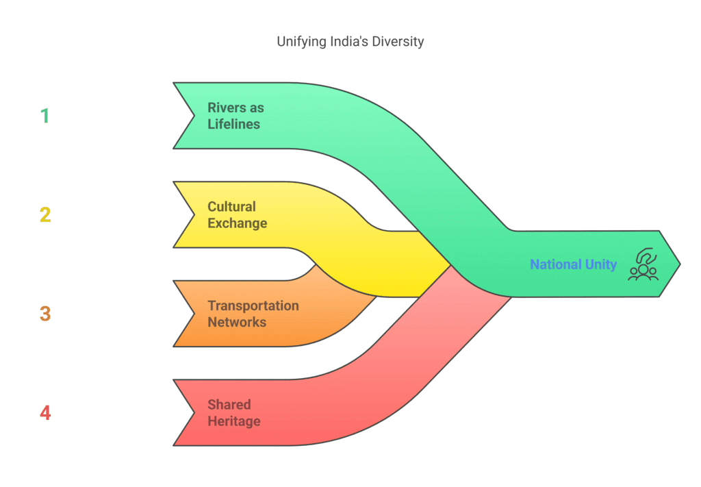
- Rivers as Lifelines: Major rivers like the Ganga, Brahmaputra, and Indus have provided water and resources for agriculture, enabling people across different regions to depend on these rivers for their livelihoods. This common resource has helped create a sense of unity among people.
- Cultural Exchange: India's vast geographical features like the Himalayas, deserts, and coasts have not isolated people but have facilitated cultural exchange. Trade routes across the mountains, plains, and coasts have allowed people to interact, share ideas, and build relationships.
- Transportation Networks: The flat Gangetic Plains and the development of roads and railways have made it easier for people to travel, trade, and connect with others from different parts of the country. This connectivity has helped unify diverse communities.
- Shared Heritage: India's history, influenced by its geography, has fostered a shared sense of identity and culture that transcends regional differences, allowing people from different parts of India to feel connected to a common heritage.
FAQs on NCERT Solutions: Geographical Diversity of India
| 1. What are the main physical features that make India's geography so diverse? |  |
| 2. How do monsoons affect different parts of India differently? | |
| 3. Why does India have so many different types of soil and vegetation zones? | |
| 4. What's the difference between the Northern Plains and the Deccan Plateau in terms of geography and climate? | |
| 5. How do India's geographical features influence where people live and what they grow? | |


