CBSE Class 7 > Class 7 Notes > Social Science - New NCERT ( Part 1 and Part 2) > Mind Map: Geographical Diversity of India
Mind Map: Geographical Diversity of India

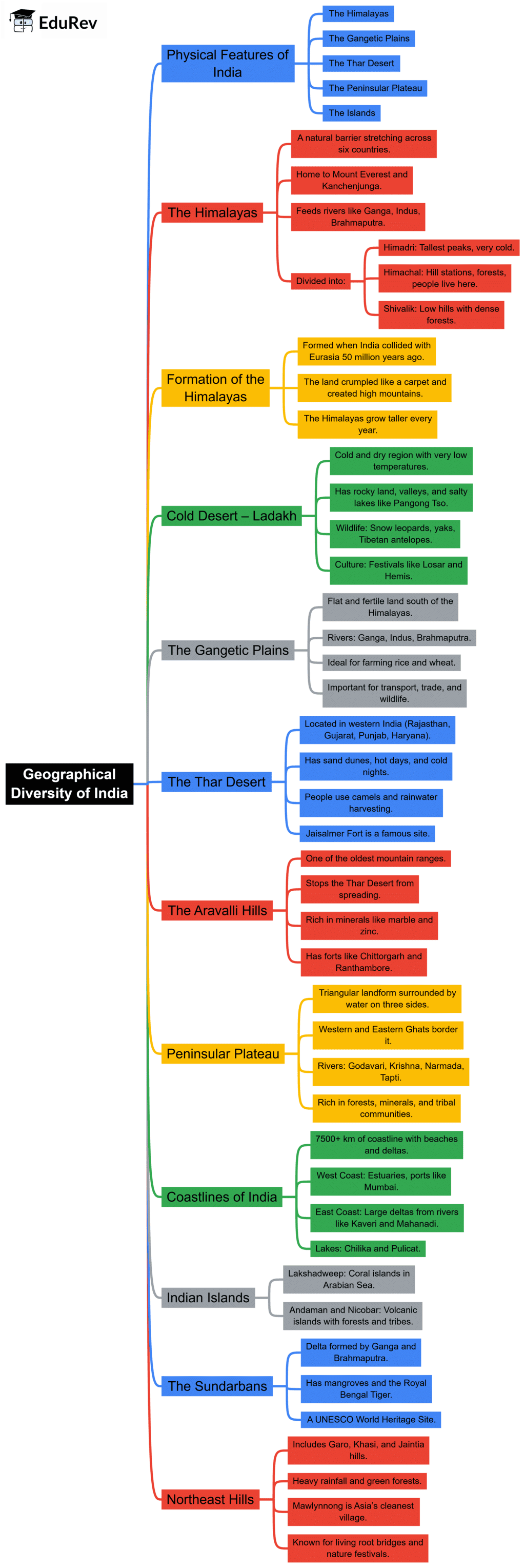
The document Mind Map: Geographical Diversity of India is a part of the Class 7 Course Social Science Class 7 - New NCERT ( Part 1 and Part 2).
All you need of Class 7 at this link: Class 7
FAQs on Mind Map: Geographical Diversity of India
| 1. What are the main physical features that make India's geography so diverse? |  |
Ans. India's geographical diversity stems from its varied mountain ranges, plateaus, plains, and coastal areas. The Himalayas in the north, the Deccan Plateau in the south, the Indo-Gangetic Plains, and the Western and Eastern Ghats create distinct regional climates and landscapes. These physical features influence vegetation patterns, rainfall distribution, and human settlement across different zones, making India geographically unique for Class 7 Social Science studies.
| 2. How do climate zones differ across India's regions? | |
Ans. India experiences tropical, subtropical, temperate, and arid climate zones depending on latitude, altitude, and monsoon patterns. The coastal areas receive heavy rainfall, the Deccan Plateau is semi-arid, the Himalayas have alpine conditions, and the Thar Desert is extremely dry. These climatic variations create distinct ecosystems and influence agriculture, vegetation types, and the distribution of flora and fauna across Indian geography.
| 3. Why is the monsoon system so important for understanding India's geographical diversity? | |
Ans. The monsoon system brings seasonal rainfall that shapes India's agriculture, water resources, and regional economies. The southwest monsoon (June to September) delivers moisture to coastal and western regions, while the northeast monsoon affects southern and eastern areas. Understanding monsoon patterns is crucial for grasping how geographical diversity influences crop cultivation, river systems, and human activities across different parts of India.
| 4. What natural resources are found in different geographical regions of India? | |
Ans. India's regions contain distinct natural resources shaped by geological formations. The Himalayas provide minerals and forests; the Deccan Plateau holds coal, iron ore, and diamonds; the Indo-Gangetic Plains offer fertile soil; and coastal areas provide fish and salt. These resource distributions reflect India's geological diversity and support different economic activities, making geographical knowledge essential for understanding India's development patterns.
| 5. How does terrain affect vegetation and wildlife distribution across India? | |
Ans. Terrain and climate determine vegetation zones and wildlife habitats across Indian geography. Mountain forests support alpine species, tropical rainforests thrive in Western Ghats, grasslands dominate the Deccan, and deserts host adapted fauna. Altitude, rainfall, soil type, and temperature variations create distinct biodiversity zones. Mind maps help visualise these interconnections between landforms, climate, vegetation patterns, and animal populations across India's diverse geographical regions.
About this Document

9.1K Views

4.74/5 Rating

Apr 18, 2026 Last updated
Related Exams
Document Description: Mind Map: Geographical Diversity of India for Class 7 2026 is part of Social Science Class 7 - New NCERT ( Part 1 and Part 2) preparation. The notes and questions for Mind Map: Geographical Diversity of India have been prepared according to the Class 7 exam syllabus. Information about Mind Map: Geographical Diversity of India covers topics like and Mind Map: Geographical Diversity of India Example, for Class 7 2026 Exam. Find important definitions, questions, notes, meanings, examples, exercises and tests below for Mind Map: Geographical Diversity of India.
Introduction of Mind Map: Geographical Diversity of India in English is available as part of our Social Science Class 7 - New NCERT ( Part 1 and Part 2) for Class 7 & Mind Map: Geographical Diversity of India in Hindi for Social Science Class 7 - New NCERT ( Part 1 and Part 2) course. Download more important topics related with notes, lectures and mock test series for Class 7 Exam by signing up for free. Class 7: Mind Map: Geographical Diversity of India
Description
Mind Map: Geographical Diversity of India of SST Class 7 provides you one-page visual summary of the chapter covering all the important topics. Download the PDF from EduRev.
Information about Mind Map: Geographical Diversity of India
In this doc you can find the meaning of Mind Map: Geographical Diversity of India defined & explained in the simplest way possible. Besides explaining types of Mind Map: Geographical Diversity of India theory, EduRev gives you an ample number of questions to practice Mind Map: Geographical Diversity of India tests, examples and also practice Class 7 tests


Related Searches
Exam, past year papers, shortcuts and tricks, Semester Notes, MCQs, pdf , Free, Sample Paper, Objective type Questions, Mind Map: Geographical Diversity of India, Extra Questions, Previous Year Questions with Solutions, ppt, mock tests for examination, Important questions, practice quizzes, video lectures, Mind Map: Geographical Diversity of India, study material, Summary, Viva Questions, Mind Map: Geographical Diversity of India;