Half Yearly Class 7 Social Studies Set 1 (Solutions)

Maximum Marks: 80
Time: 3 Hours
General Instructions:
(i) The question paper consists of 34 questions divided into five sections: A, B, C, D and E.
(ii) All questions are compulsory.
(iii) Section A: Questions 1 to 15 are multiple-choice questions, carrying 1 mark each. Select the most appropriate response.
(iv) Section B: Questions 16 to 22 are short-answer questions, carrying 2 marks each.
(v) Section C: Questions 23 to 30 are short-answer questions, carrying 4 marks each.
(vi) Section D: Questions 31 to 32 are short-answer questions, carrying 5 marks each.
(vii) Section E: Question 33 Case Based Question, carrying 5 marks and Question 34 : Map Based Question, carrying 4 marks.
(viii) Write answers neatly and legibly.
Syllabus: Geographical Diversity of India, Understanding the Weather, Climates of India, New Beginnings: Cities and States, The Rise of Empires, The Age of Reorganisation, The Gupta Era: An Age of Tireless Creativity, How the Land Becomes Sacred, From the Rulers to the Ruled: Types of Governments, The Constitution of India: An Introduction, From Barter to Money, Understanding Markets.
Section A
a) Stratosphere
b) Troposphere
c) Ozone Layer
d) Mesosphere
Ans: b) Troposphere
Sol: The troposphere is the layer of the Earth's atmosphere closest to the surface, and it is where almost all weather phenomena take place.
a) Thermometer
b) Rain gauge
c) Barometer
d) Anemometer
Ans: c) Barometer
Sol: The instrument used to measure atmospheric pressure is called a barometer.
a) Winter
b) Spring
c) Summer
d) Autumn
Ans: c) Summer
Sol: The Indian subcontinent receives rainfall from the southwest monsoon during the summer season.
a) Kanishka
b) Kharavela
c) Pushyamitra Śhunga
d) Gautamiputra Satakarni
Ans: c) Pushyamitra Śhunga
Sol: The Śhunga dynasty was founded by his commander-in-chief Puṣhyamitra Śhunga after he assassinated the last Maurya emperor around 185 BCE.
a) Chandragupta I
b) Samudragupta
c) Chandragupta II
d) Aryabhata
Ans: b) Samudragupta
Sol: Samudragupta is the Gupta ruler whose military achievements are praised in the Prayaga Prashasti inscription.
a) To outline the basic principles and laws of a nation
b) To list daily weather predictions
c) To describe ancient trade routes
d) To explain market prices
Ans: a) To outline the basic principles and laws of a nation
Sol: A constitution is a document that spells out a nation's basic principles and laws and outlines the framework of government.
a) Increased wind speed
b) Decreased atmospheric pressure and air density
c) Proximity to the sea
d) Latitude changes
Ans: b) Decreased atmospheric pressure and air density
Sol: The temperature decreases with increasing altitude because the air gets thinner, resulting in decreased atmospheric pressure and air density.
a) Guptas
b) Shungas
c) Cholas, Cheras, and Pandya
d) Kushanas
Ans: c) Cholas, Cheras, and Pandya
Sol: The three powerful kingdoms whose works are collectively known as Sangam literature are the Cheras, the Cholas and the Pānḍyas.
(a) Democracy
(b) Monarchy
(c) Oligarchy
(d) Republic
Ans: (c)
Sol: An oligarchy is a government where a few powerful individuals hold authority.
(a) Paper notes
(b) Goods and services
(c) Gold bars
(d) Digital currency
Ans: (b)
Sol: Before coins, goods and services were exchanged directly in the barter system.
(a) Varanasi
(b) Bodh Gaya
(c) Amritsar
(d) Tirupati
Ans: (b)
Sol: Bodh Gaya is sacred for Buddhists as the place where Buddha attained enlightenment.
(a) Thar Desert
(b) Western Ghats
(c) Gangetic Plains
(d) Himalayan Foothills
Ans: (b)
Sol: The Western Ghats receive heavy rainfall, supporting lush greenery and biodiversity.
(a) Chandragupta Maurya
(b) Bindusara
(c) Ashoka
(d) Samudra gupta
Ans: (c)
Sol: Ashoka promoted Dhamma, a set of ethical principles, after embracing Buddhism.
(a) The king
(b) The citizens
(c) The priests
(d) The military
Ans: (b)
Sol: In a republic, citizens elect representatives to govern on their behalf.
(a) Lack of technology
(b) Need for double coincidence of wants
(c) Use of coins
(d) High transaction speed
Ans: (b)
Sol: The barter system requires both parties to want what the other offers.
Section B
Ans: Weather is the state of the Earth's atmosphere at a particular time and place.
Its five elements are temperature, precipitation, atmospheric pressure, wind, and humidity.
Ans: Weather is what we experience from day to day, such as rain or sunshine, while climate is the long-term pattern of weather in a region over several decades.
Ans: The Western Ghats act as a natural barrier, causing heavy rainfall on their western slopes during the southwest monsoon, while the eastern side receives less rain.
Ans: Pushyamitra Shunga was the founder of the Shunga dynasty who assassinated the last Maurya emperor. He performed the Ashvamedha yajna and protected his empire from invaders.
Ans: Geographical diversity refers to the vast variety of physical landforms present across India, which is part of the Indian Subcontinent. These features include major zones such as the Great Mountain Zone (Himalayas), the fertile plains (Gangetic), the desert region (Thar), the peninsular plateau, and the islands. This diversity profoundly influences the regional climate, culture, economy, and lifestyle of the population, fostering variety in language, food, and traditions across the country.
Ans: The Indo-Gangetic Plains are nourished by mighty rivers originating from the Himalayas. Two major rivers that contribute significantly to the fertility of these plains are the Ganga and the Yamuna. These river systems, along with their extensive networks of tributaries, enrich the soil by depositing alluvial soil, which is ideal for agriculture and supports a large proportion of India's population.
Ans: The barter system is the earliest form of exchange, involving the direct trading of goods or services for other goods and services without the use of money. People in ancient times used commodities such as cowrie shells, salt, tobacco, or cattle in these exchanges. Example: A farmer trades his extra wheat for a potter's clay pots, or a community trades its handmade goods for rice cakes.
Section C
Ans: Temperature shows how hot or cold the air is and is measured with a thermometer. Traditional thermometers use mercury or alcohol that expand and contract with temperature changes, while modern digital thermometers give accurate readings in Celsius or Fahrenheit. Two important temperature statistics are:
(i) Range of temperature: The difference between the maximum and minimum temperatures of a period. For example, if the day's maximum is 32°C and minimum is 18°C, the range is 14°C.
(ii) Mean daily temperature: The average of the maximum and minimum temperatures. For example, (32 + 18) ÷ 2 = 25°C. These statistics help study weather patterns and temperature changes.
Ans: India's climate varies due to factors like latitude, altitude, distance from the sea, winds, and topography.
Latitude: Areas near the Equator are warmer, while those farther are cooler. For example, Kanniyakumari is hot, while Jammu and Kashmir are cooler.
Altitude: Higher areas are cooler. Shimla is cooler than Delhi because it is at a higher altitude.
Proximity to the sea: Coastal areas have moderate climates. Mumbai has milder summers than inland Nagpur.
Winds: Winds affect temperature and rainfall. The southwest monsoon brings rain, while dry winds from Central Asia cause cold winters. These factors together make India's climate diverse.
Ans: The Satavahanas (2nd century BCE-3rd century CE) ruled central and southern India with capitals at Amravati and Paithan. They contributed greatly to trade and art. In trade, they connected inland and foreign markets, including Rome, exporting goods like spices and textiles. Coins showing ships prove their active sea trade and prosperity. In art, they supported rock-cut Buddhist architecture, such as the Karla and Pitalkhora caves in Maharashtra. Inscriptions mention rulers and queens donating to temples and performing rituals. Their sculptures blended local and foreign styles. Thus, the Satavahanas advanced both economy and culture.
Ans: Samudragupta (c. 350-375 CE) expanded the Gupta Empire through wars and diplomacy. The Prayaga Prashasti inscription by Harisena describes his victories. He conquered many northern rulers and made others his tributaries. In the south, he defeated kings but allowed them to rule under his authority. He performed the Ashvamedha yajna to show power and issued coins marking his success. His empire stretched across most of northern India. Samudragupta's conquests laid the foundation for the Gupta Golden Age of peace and prosperity.
Ans: The Western Ghats are a crucial geographical feature that significantly influences India's climate, running along the western coast like a massive wall.
1. Monsoon Blocking: The Ghats intercept the moisture-laden Southwest Monsoon winds.
2. Heavy Rainfall: This obstruction causes the western slopes of the range to receive heavy rainfall, supporting unique biodiversity, lush greenery, and dense forests.
3. Rain-Shadow Effect: On the eastern side of the Ghats, the air is dried, creating a rain-shadow effect.
This results in significantly drier conditions in regions like Karnataka interior and Deccan Plateau regions, profoundly affecting regional agriculture and ecology.
Ans: Rivers are considered sacred in Indian culture due to the synthesis of spiritual, cultural, and ecological perceptions.
1. Divine Association: Rivers are widely worshipped as deities (devīs) and are associated with spiritual purification.
2. Lifelines of Civilization: Rivers are crucial lifelines for the civilization, providing water for agriculture, drinking, and industries. This sustenance generates immense reverence, reflected in ancient texts like the Ṛigveda, which contains hymns praising rivers (nadīstuti sūkta).
3. Tīrtha Designation: Sacred sites (tīrthas) are often located on river banks.
Example: The Ganga River is sacred because Hindus believe bathing in it cleanses sins. Its banks host major pilgrimage sites like Varanasi, reinforcing its status as a vital part of India's sacred geography.
Ans: The transition to a monetary economy using coins significantly improved trade by resolving the limitations of the earlier barter system.
1. Eliminated Double Coincidence of Wants: Coins served as a common medium of exchange, eliminating the need for both trading parties to mutually want what the other offered-the major drawback of barter.
2. Standardization and Efficiency: Coins provided a common standard measure of value (denomination), standardizing trade and increasing market efficiency. They were also more portable, divisible, and durable than commodities.
3. Facilitated Large-Scale Trade: The standardization facilitated both local and long-distance trade.
The use of common coinage, often controlled by rulers, connected distant regions and supported the brisk commerce necessary for economic growth and urban stability.
Ans: The Thar Desert, a vast arid region, imposes unique challenges that have necessitated significant lifestyle adaptations in Rajasthan.
1. Economic Limitations: The arid conditions and harsh climate (high daytime temperatures and cold nights) limit extensive agriculture. This often pushes communities toward a nomadic or seminomadic lifestyle, with a reliance primarily on animal husbandry.
2. Water Scarcity Adaptations: Water is extremely scarce. People have developed ingenious and traditional water conservation methods, such as taanka or kunds, which are used to store rainwater, often for drinking purposes. Water used for rinsing may even be reused for watering plants.
3. Cultural Practices: The limited resources require people to adapt their food habits, clothing, and overall lifestyle to these harsh conditions. Unique cultural expressions, such as desert festivals, celebrate the unique environment.
Section D
Ans: Weather elements-temperature, precipitation, atmospheric pressure, wind, and humidity-are measured using specific instruments to monitor and predict conditions.
Thermometer for temperature: Measures how hot or cold the air is. Example: Digital thermometer, preferred for precision and data recording, reading in Celsius (e.g., 25°C ambient temperature).
Rain gauge for precipitation: Measures the amount of rainfall or other water forms like snow. Example: Standard rain gauge with a funnel collecting water in a cylinder, measured in millimeters (e.g., 50 mm of rain in a day).
Barometer for atmospheric pressure: Measures air pressure, indicating weather changes like storms. Example: Mercury barometer, where pressure pushes mercury up a tube, read in millibars (e.g., 1013 mb for normal pressure).
Anemometer for wind: Measures wind speed and direction. Example: Anemometer measures wind speed; wind vane measures direction.
Hygrometer for humidity: Measures water vapor in air as relative humidity (0-100%). Example: Digital hygrometer, showing percentage (e.g., 70% relative humidity, indicating moist air). These instruments are often integrated in Automated Weather Stations (AWS) for continuous data collection.
Ans: India's diverse geography-leading to it being called a 'mini-continent'-has profoundly shaped its civilization, cultures, economies, and history.
1. The Himalayas (The Great Mountain Zone): This massive range forms a natural barrier in the north, historically providing protection and influencing climate. The Himalayas are the "Water Tower of Asia" as their melting snow feeds major perennial rivers like the Ganga and Indus. These mountains are considered sacred, and the varying altitudes dictate unique, resilient lifestyles and limited human settlement in the highest ranges.
2. The Indo-Gangetic Plains: These vast, flat lands are highly fertile due to the alluvial soil deposited by major river systems like the Ganga, Indus, and Brahmaputra. This fertility sustains intensive agriculture and has historically supported dense populations and the rise of India's earliest organized states, the mahājanapadas, and later empires. The flat terrain also enabled the development of elaborate transportation networks.
3. The Peninsular Plateau and Ghats: This triangular region is rich in minerals and forests. The Western Ghats run along the coast, blocking monsoon winds and causing heavy rainfall, leading to rich biodiversity. This resource base and varied climate have shaped distinct regional economies and supported diverse tribal communities.
4. The Thar Desert: This arid region marks the western limits of India. Its harsh conditions necessitate unique cultural adaptations, including reliance on animal husbandry and the development of ingenious water conservation methods such as taanka. These features resulted in regional diversity in language, food, and traditions.
Section E
Q33. Case Based Question ( 5 Marks)
Vikram and Anjali are studying the development of iron metallurgy in ancient India for their history project. Vikram is fascinated by how the use of iron helped shape the progress of Indian society. He wonders about the role of iron in improving people's daily lives. Anjali explains that iron tools made farming much easier and more efficient, leading to better harvests. The increased food production supported a growing population. She goes on to explain how iron weapons made defense stronger, which allowed kingdoms to expand and protect their territories. This, in turn, encouraged trade across regions because people felt safer traveling and exchanging goods. The rise of iron metallurgy also led to the creation of new technologies, like the plough and improved tools for construction and craftsmanship. Together, these advancements helped ancient India grow and develop economically and socially.
i. How did iron help ancient Indian societies grow?
Ans: Iron tools improved farming, while iron weapons strengthened defense and promoted trade, helping societies grow.
ii. Why is iron still important today?
Ans: Iron is used in construction, transportation, and manufacturing, making it essential for modern industries.
iii. How did iron lead to more trade in ancient India?
Ans: Iron tools improved agriculture, creating surplus crops for trade. Iron weapons made defense stronger, allowing safer trade routes.
iv. What are some modern uses of iron?
Ans: Iron is used in building bridges, making vehicles, and manufacturing tools.
v. What was iron mainly used for in ancient India?
A) Coins
B) Weapons and tools
C) Clothing
D) Jewelry
Ans: B) Weapons and tools
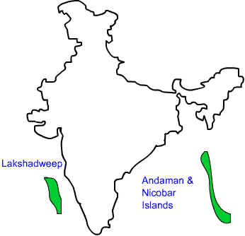
Q.34: Map Based Question (4 Marks)
i. On the physical map, locate and outline the Peninsular Plateau.
ii. Name one river that originates in the Peninsular Plateau and flows into the Bay of Bengal.
iii. Locate and mark the Lakshadweep Islands and Andaman and Nicobar Islands on the physical map.
Ans:
a) Do it Yourself.b) The Godavari River originates in the Peninsular Plateau (in Maharashtra) and flows eastward into the Bay of Bengal. (Mark its path from central Maharashtra through Andhra Pradesh to the Bay of Bengal.)
c) Marking of the Lakshadweep Islands and Andaman and Nicobar Islands on the physical map is as follows:
FAQs on Half Yearly Class 7 Social Studies Set 1 (Solutions)
| 1. What topics are covered in the Class 7 Social Studies Half Yearly Exam? |  |
| 2. How should I prepare for the Half Yearly Social Studies exam effectively? | |
| 3. Are there any specific study materials recommended for Class 7 Social Studies? | |
| 4. What are some common types of questions asked in the exam? | |
| 5. How can I manage my time during the Social Studies exam? | |


