Half Yearly Class 7 Social Studies Set 2 (Solutions)

Maximum Marks: 80
Time: 3 Hours
General Instructions:
(i) The question paper consists of 34 questions divided into four sections: A, B, C, and D.
(ii) All questions are compulsory.
(iii) Section A: Questions 1 to 15 are multiple-choice questions, carrying 1 mark each. Select the most appropriate response.
(iv) Section B: Questions 16 to 22 are short-answer questions, carrying 2 marks each.
(v) Section C: Questions 23 to 31 are short-answer questions, carrying 4 marks each.
(vi) Section D: Questions 31 to 32 are short-answer questions, carrying 5 marks each.
(vii) Section E: Question 33 Case Based Question, carrying 5 marks and Question 34 : Map Based Question, carrying 4 marks.
(vii) Write answers neatly and legibly.
Syllabus: Geographical Diversity of India, Understanding the Weather, Climates of India, New Beginnings: Cities and States, The Rise of Empires, The Age of Reorganisation, The Gupta Era: An Age of Tireless Creativity, How the Land Becomes Sacred, From the Rulers to the Ruled: Types of Governments, The Constitution of India: An Introduction, From Barter to Money, Understanding Markets.
Section A
Q1. What unit is used to measure rainfall? (1 Mark)
a) Degrees Celsius
b) Millibars
c) Millimetres
d) Kilometres per hour
Ans: c) Millimetres
Sol: Rainfall is measured in millimeters (mm) by a rain gauge, which collects the water in a cylinder and measures its depth on an attached scale.
Q2. Which region in India is known for its black soil, suitable for cotton cultivation? (1 Mark)
a) Northern Plains
b) Deccan Plateau
c) Coastal Plains
d) Himalayan Region
Ans: b) Deccan Plateau
Sol: The Deccan Plateau is known for its black soil, which is ideal for cultivating specific crops such as cotton.
Q3. Who was the Satavahana ruler named after his mother Gautami? (1 Mark)
a) Pushyamitra
b) Gautamiputra Satakarni
c) Kharavela
d) Kanishka
Ans: b) Gautamiputra Satakarni
Sol: Gautamīputra Sātakarṇi followed the Sātavāhana tradition of naming princes after their mothers, in this case, Gautamī Balaśhrī.
Q4. In the barter system, goods are exchanged: (1 Mark)
a) Using coins
b) Without a medium of exchange
c) Through digital payments
d) Using paper currency
Ans: b) Without a medium of exchange
Sol: The barter system is the earliest form of exchange where goods are directly swapped without the use of money as a medium.
Q5. Which dynasty built the Karla caves? (1 Mark)
a) Guptas
b) Satavahanas
c) Shungas
d) Pallavas
Ans: b) Satavahanas
Sol: The Sātavāhanas dynasty contributed to the development and carving of the Karla caves, which were constructed for Buddhist monks.
Q6. Which geographical feature supports dense forests in India? (1 Mark)
a) Thar Desert
b) Eastern Ghats
c) Indo-Gangetic Plains
d) Aravali Range
Ans: b) Eastern Ghats
Sol: The Eastern Ghats are a geographical feature that supports dense forests because the region receives adequate rainfall.
Q7. Who chaired the Drafting Committee of the Constitution? (1 Mark)
a) Rajendra Prasad
b) B.R. Ambedkar
c) Sachidananda Sinha
d) Jawaharlal Nehru
Ans: b) B.R. Ambedkar
Sol: Dr. B.R. Ambedkar, an eminent social reformer, chaired the Drafting Committee responsible for preparing the initial text of the Constitution.
Q8. In which government does power pass through family lineage? (1 Mark)
a) Republic
b) Monarchy
c) Oligarchy
d) Democracy
Ans: b) Monarchy
Sol: In a monarchy, the position of ruler is hereditary, meaning power passes through family lineage, often to the eldest son of the monarch.
Q9. Which Gupta figure authored the Aryabhatiya? (1 Mark)
a) Kalidasa
b) Aryabhata
c) Varahamihira
d) Faxian
Ans: b) Aryabhata
Sol: Āryabhaṭa, a figure from the Gupta era, authored the Āryabhaṭīya, a treatise focused on mathematics and astronomy.
Q10. Which region in India is prone to frequent flooding? (1 Mark)
a) Deccan Plateau
b) Northern Plains
c) Western Ghats
d) Thar Desert
Ans: b) Northern Plains
Sol: The Northern Plains, including states like Uttar Pradesh and Bihar, are prone to frequent flooding due to heavy river flow.
Q11. Which factor moderates coastal temperatures? (1 Mark)
a) Latitude
b) Proximity to sea
c) Winds
d) Topography
Ans: b) Proximity to sea
Sol: Proximity to the sea moderates coastal temperatures because the sea heats up and cools down slower than land, keeping the temperature range narrower.
Q12. What made the barter system inefficient for large-scale trade? (1 Mark)
a) Use of heavy coins
b) Lack of a standard value
c) Digital transactions
d) Excessive speed
Ans: b) Lack of a standard value
Sol: The barter system lacked a common standard measure of value, which made comparing the worth of goods cumbersome and led to trade inefficiency.
Q13. What is the Directive Principles of State Policy? (1 Mark)
a) Enforceable rights
b) Guiding principles for governance
c) Historical art
d) Weather instruments
Ans: b) Guiding principles for governance
Sol: The Directive Principles of State Policy (DPSP) are considered guidelines for governance, representing goals the government should strive to achieve for the country's progress.
Q14. Which Mauryan king issued edicts in Prakrit, encouraging Dhamma and promoting a benevolent image? (1 Mark)
a) Chandragupta Maurya
b) Ashoka
c) Mahāpadma Nanda
d) Ajātaśhatru
Ans: b) Ashoka
Sol: King Ashoka issued edicts, primarily written in the popular language Prakrit, to encourage his subjects to follow Dhamma (moral law) and project a compassionate image.
Q15. What is a wholesale market? (1 Mark)
a) Sells goods directly to consumers
b) Sells in bulk quantities
c) Sells only agricultural products
d) Sells imported goods only
Ans: b) Sells in bulk quantities
Sol: A wholesale market is characterized by wholesalers buying and selling goods in large or bulk quantities from the manufacturer or producer.
Section B
Q16. What is relative humidity? (2 marks)
Ans: Relative humidity refers to the amount of water vapour present in the air. It is measured as a comparison between the existing amount of vapour and the maximum amount the air can hold. Air that is completely saturated with water vapour is rated at 100% humidity, while air with no vapour is rated at 0%. Typically, humid weather registers a relative humidity between 60% and 80%.
Q17. Name two sacred rivers in India and their religious significance. (2 marks)
Ans: Two revered rivers are the Ganga and the Yamuna. Rivers are worshipped as deities (devīs) in Indian culture. The Ganga is highly sacred in Hinduism; followers believe that a dip in the river during prescribed periods is considered most auspicious and purifies sins. The rivers are also critical lifelines for Indian civilization, providing water for farming and sustaining large populations.
Q18. What was the Hathigumpha inscription? (2 marks)
Ans: The Hāthīgumphā inscription is a historical record written in the Brahmi script. It details the yearly accomplishments and military campaigns of King Khāravela of the Chedi dynasty. It also records his benevolent works for the welfare of his people and proudly declares that he respected every sect and ensured the repair of every temple.
Q19. What is the difference between a dictatorship and a democracy? (2 marks)
Ans: In a dictatorship, one person or a small group possesses absolute power, often without limits imposed by a constitution or law. They are not accountable to the populace. A democracy, conversely, is characterized as the "rule of the people"; the government is formed by elected leaders chosen through voting (citizen participation) and is fully accountable to its citizens for its actions.
Q20. Name two Fundamental Duties. (2 marks)
Ans: Fundamental Duties are responsibilities of citizens designed to promote discipline and commitment to the nation, guiding ethical conduct,,. Two of these duties are:
To abide by the Constitution and respect its ideals and institutions, including the National Flag and the National Anthem.
To defend the country and render national service when citizens are called upon to do so.
Q21. Name two ancient cities known for their religious importance. (2 marks)
Ans: Varanasi and Sarnath are two ancient cities known for religious importance. Varanasi (Kāśhī) is a sacred site for Hindus, located on the Ganga River, which attracts pilgrims and traders. Sarnath, near Varanasi, is especially significant for Buddhists, as it is the place where the Buddha gave his first teaching.
Q22. Describe domestic markets. (2 marks)
Ans: A domestic market is defined as a market where goods and services are bought and sold exclusively within the geographical boundaries of the country. In these markets, the buyers and sellers are both located inside the nation, meaning that the trade is focused internally rather than across international borders. This market structure facilitates supply chains serving final consumers with necessary goods and services.
Section C
Ans: Climate change refers to significant, long-term changes in climate on a planetary or regional scale. While natural processes drove it in the past, since the 19th century, human activities have been the primary cause. Causes: Burning fossil fuels for energy, transportation, and industry releases greenhouse gases like carbon dioxide, trapping heat. Deforestation reduces carbon absorption by trees. Other activities include agriculture (methane from livestock) and waste decomposition. Effects in India: Warmer temperatures lead to shorter winters and melting glaciers, causing glacial bursts and floods (e.g., 2013 Uttarakhand). Extreme weather increases, with more intense monsoons causing floods, landslides, and cyclones, or droughts affecting agriculture and water availability. Rising sea levels threaten coastal areas. These impact economy (crop failures), society (displacements), and ecosystems (biodiversity loss). Preparation includes mitigation like reducing emissions and adaptation strategies.
Ans: Centers of learning flourished in ancient India, contributing significantly to its intellectual and cultural legacy.
1. Intellectual Hub: Nalanda was renowned as a center of learning that attracted scholars and students from across Asia. This exchange of knowledge fostered intellectual development across the Subcontinent.
2. Diverse Curriculum: Nalanda provided education in wide-ranging subjects, including Buddhism, philosophy, mathematics, and astronomy. Such institutions promoted the dissemination of ideas, teachings, and literature, furthering the growth of Indian civilization.
3. Cultural Integration: Educational centers, much like pilgrimage sites, served as convergence points for people from diverse backgrounds, promoting cultural exchange and strong socio-economic bonds across India.
Ans: The Shunga dynasty was founded by Pushyamitra Shunga around 185 BCE after the Maurya empire's decline. They contributed to revival of Vedic traditions, literature, and art during the Age of Reorganisation. They revived Vedic rituals, such as the ashvamedha yajna performed by Pushyamitra, emphasizing Brahmanical practices. In literature, they patronized Sanskrit works, including Patanjali's Yoga Sutras and Mahabhashya on grammar, promoting scholarly activities. In art, the Shungas enhanced Buddhist stupas, adding railings and gateways to the Bharhut Stupa with intricate carvings depicting Jataka stories and daily life. They also supported sculptures in stone, blending religious themes with artistic expression. Overall, their contributions helped reorganize society, blending Vedic and Buddhist elements, influencing cultural confluence.
Ans: Democracy, compared to monarchy, offers critical advantages centered on public participation and rights.
1. Citizen Participation and Accountability: Democracy ensures citizen participation because leaders are elected through voting, making the government accountable to the people who chose them. In a traditional monarchy, power is hereditary, and the ruler is often not bound by a constitution or accountable to the public.
2. Equality and Freedom: Democracy upholds fundamental principles of equality (everyone treated equally before the law) and freedom (citizens have the right to express opinions and make choices). While some monarchies were expected to rule according to rājadharma (moral welfare), absolute monarchs hold absolute power and may subjugate their people.
3. Change of Leadership: In a democracy, citizens can change the government through elections if it fails to perform properly. In a monarchy, power passes strictly through family lineage.
Ans: Amendments are changes or modifications to the Constitution to address emerging needs, rigorously debated in Parliament and sometimes in state assemblies. Public opinions may be sought, and some amendments can be initiated by popular movements. This flexibility makes the Constitution a living document.
Examples:
1. The 42nd Amendment in 1976 added 'Part IV-A: Fundamental Duties' to emphasize citizens' responsibilities.
2. The 73rd Amendment in 1992 integrated the Panchayati Raj System, decentralizing power to local levels, which was not in the original Constitution.
These amendments ensure the Constitution evolves, like allowing the national flag to be flown at homes after a 2004 Supreme Court ruling under Fundamental Rights.
Ans: Ports were vital for the expansion of ancient Indian trade, serving as critical gateways for maritime activity.
1. Maritime Connection: Ports like Lothal (a major port in ancient India) and those along the western and eastern coasts facilitated maritime trade with regions outside India, such as Mesopotamia and the Middle East.
2. Economic Flow: Ports enabled the export and import of valuable commodities, including textiles, spices, gold, and gems. This flow of goods generated significant wealth accumulation for the cities connected to them.
3. Urban Development: The revenue and commerce generated at ports supported urban development and the growth of commercial centers. They linked India's internal trade routes (like the Dakṣhiṇapatha) to global networks, strengthening the economic stability necessary for state formation.
Ans: The northeast monsoon occurs in winter when the pattern of winds reverses from the southwest monsoon. In summer, low pressure over the Indian landmass draws moist winds from the Indian Ocean, causing heavy rain. In winter, the landmass cools rapidly, creating high pressure over land and low pressure over the sea. Dry winds blow from land to ocean but pick up moisture while passing over the Bay of Bengal. These moisture-laden winds bring rain to eastern and southern India, particularly Tamil Nadu, Andhra Pradesh, and Kerala, from October to December. This monsoon is vital for rabi crops and water replenishment in these regions.
Ans: Sacred sites (tīrthas) were powerful magnets that drove economic activity and interconnected the Indian Subcontinent.
1. Pilgrim-Trader Convergence: Sacred sites like Varanasi attracted massive numbers of pilgrims and devotees, creating a constant demand for goods, services, and accommodation. This fostered markets and economic prosperity in the area.
2. Overlapping Routes: The pilgrimage routes (tīrthayātrās), which crisscrossed India, often overlapped with major trade routes (Uttarāpatha and Dakṣhiṇapatha). This meant traders could reach distant markets while pilgrims could easily access necessary wares.
3. Dissemination of Goods: Travelers, including merchants doubling as pilgrims, exchanged goods, shared resources, and transmitted information on markets and supply/demand, enriching commerce and economic prosperity over large geographies.
Section D
Ans: The Maurya Empire, founded by Chandragupta Maurya around 321 BCE, was India's first unified empire, built upon the foundation of the Magadhan kingdom. 1. The Rise of the Mauryas: Chandragupta, aided by his mentor Kauṭilya (Chāṇakya), overthrew the unpopular Nanda dynasty. Magadha's geographical advantages were key: access to fertile land in the Ganga plains, vast forests for timber and war elephants, and nearby hills providing iron ore for stronger weapons and agriculture. Chandragupta expanded the empire widely, defeating the Greek satraps in the northwest and integrating territories across the subcontinent. 2. Centralized Administrative System: The Mauryas established a strong, centralized administration based on Kauṭilya's principles outlined in the Arthaśhāstra. The key components (saptānga) included:
1. The King (swāmi): The central authority, advised by the council of ministers (amātya).
2. Territorial Organization (janapada): The vast empire was divided into provinces with provincial governors and a strong administration.
3. Law and Order (daṇḍa): Security and justice were paramount, ensured through a robust system and sometimes a network of spies.
4. Treasury (koṣha): An efficient system of tax collection was necessary to maintain a large army and fund the administration and infrastructure, fueling prosperity.
Ans: A landslide is the sudden collapse of rock, soil, or debris, common in hilly and mountainous regions like Himachal Pradesh, Uttarakhand, Sikkim, Arunachal Pradesh, and the Western Ghats. These events often occur during the monsoon season.
Causes:
1. Landslides are triggered by natural factors such as heavy rain, earthquakes, or volcanic activity, which destabilize slopes.
2. Human activities increase risks, including deforestation (cutting down forests), improper infrastructure building without approved methods, and construction of too many buildings that block natural water flow.
3. Urban surfaces like concrete or asphalt prevent water absorption, exacerbating the issue. For example, continuous heavy rain over several days can cause glacial bursts leading to landslides, as in the 2013 Uttarakhand disaster.
Effects:
1. Landslides result in loss of human and animal life, damage to property and infrastructure, uprooting of trees, and soil erosion. They disrupt local economies, displace communities, and degrade ecosystems.
2. In the 2013 Uttarakhand event, areas around the Kedarnath temple were destroyed, villages washed away, roads and bridges damaged, and about 6,000 people lost their lives.
3. These events strain socioeconomic conditions and require rescue efforts by organizations like the National Disaster Response Force (NDRF). Preventive measures include avoiding deforestation, following approved construction methods, and implementing early warning systems.
Section E
Ans: The element representing the wealth and financial strength of the kingdom is the treasury or the wealth of the kingdom (koṣha).
Ans:1. Economic Prosperity: Magadha was located in the fertile Ganga plains, allowing for intensive agriculture and the production of surplus food grains. The rivers (Ganga and Son) also provided a geographical advantage for transportation and trade.2. Military Strength: Magadha's geography provided access to abundant forests for timber and war elephants. Additionally, access to iron ore from nearby hilly regions supplied materials for stronger, lighter, and sharper weapons, thereby strengthening the army's capabilities for warfare.
Ans:1. Eliminated Barter Constraints: Coins acted as a common medium of exchange, eliminating the need for the troublesome "double coincidence of wants", which was the primary limitation of the barter system.2. Standardized Value: Metallic coins provided a common standard measure of value (denomination), simplifying transactions and reducing the inefficiencies caused by the lack of a standard value in the barter system.
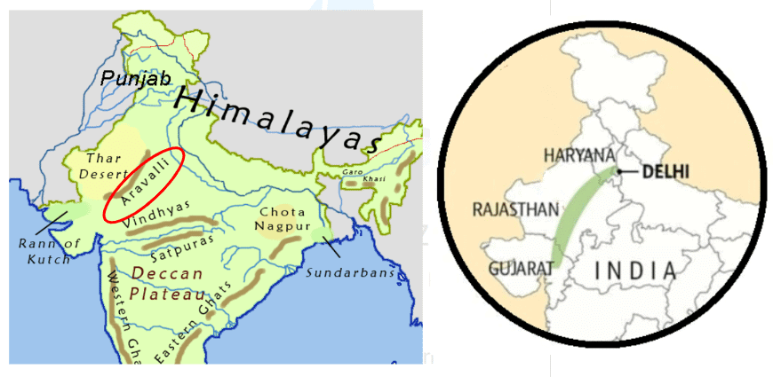
Q.34. Map Based Question (4 Marks)
a) Locate and outline the Aravalli Hills on the physical map.
b) Name two states that the Aravalli Hills span, using the political map.
c) Name the highest peak of the Aravallis.
Ans:
a) The Aravalli Hills are located in northwestern India, stretching from Gujarat through Rajasthan to Haryana and Delhi. (Outline this range on the physical map.)
b) Two states that the Aravalli Hills span are Rajasthan and Haryana.
c) Mount Abu, the highest peak of the Aravallis, is located in Rajasthan.
FAQs on Half Yearly Class 7 Social Studies Set 2 (Solutions)
| 1. What topics are covered in the Class 7 Social Studies Half Yearly exam? |  |
| 2. How can I effectively prepare for the Class 7 Social Studies Half Yearly exam? | |
| 3. Are there any specific study materials recommended for Class 7 Social Studies? | |
| 4. What type of questions can be expected in the exam format for Class 7 Social Studies? | |
| 5. How important is revision for the Class 7 Social Studies Half Yearly exam? | |


