Sample Question Paper Class 7 Social Studies Set 2 (Solutions)

Maximum Marks: 80
Time: 3 Hours
General Instructions:
(i) The question paper consists of 34 questions divided into five sections: A, B, C, D and E.
(ii) All questions are compulsory.
(iii) Section A: Questions 1 to 15 are multiple-choice questions, carrying 1 mark each.
(iv) Section B: Questions 16 to 22 are very short-answer questions, carrying 2 marks each.
(v) Section C: Questions 23 to 30 are short-answer questions, carrying 4 marks each.
(vi) Section D: Questions 31 to 32 are long-answer questions, carrying 5 marks each.
(vii) Section E: Question 33 is Case Based (5 marks) and Question 34 is Map Based (4 marks).
(viii) Write answers neatly and legibly.
Syllabus: Geographical Diversity of India, Understanding the Weather, Climates of India, New Beginnings: Cities and States, The Rise of Empires, The Age of Reorganisation, The Gupta Era: An Age of Tireless Creativity, How the Land Becomes Sacred, From the Rulers to the Ruled: Types of Governments, The Constitution of India: An Introduction, From Barter to Money, Understanding Markets. The Story of Indian Farming; India and Her Neighbours; Empires and Kingdoms: 6th to 10th Centuries; Turning Tides: 11th and 12th Centuries; India, a Home to Many; The State, the Government, and You; Infrastructure: Engine of India's Development; and Banks and the Magic of Finance.
Section A (1 Mark Each)
a) Alluvial soil
b) Black soil
c) Laterite soil
d) Desert soil
Ans: c) Laterite soil
Laterite soil is formed due to intense weathering under high rainfall and temperature. It becomes hard when dry and is commonly used in brick-making.
a) Kerala
b) Punjab
c) Sikkim
d) Gujarat
Ans: c) Sikkim
Sikkim banned chemical fertilizers and pesticides and adopted organic farming practices across the state.
a) Degrees Celsius
b) Millibars
c) Millimetres
d) Kilometres per hour
Ans: c) Millimetres
Rainfall is measured using a rain gauge, which records the depth of rainwater collected in millimetres.
a) Arabian Sea
b) Indian Ocean
c) Bay of Bengal
d) Red Sea
Ans: c) Bay of Bengal
India is surrounded by the Arabian Sea in the west, the Indian Ocean in the south, and the Bay of Bengal in the east.
a) Pushyamitra
b) Gautamiputra Satakarni
c) Kharavela
d) Kanishka
Ans: b) Gautamiputra Satakarni
The Satavahanas followed a matronymic tradition, naming rulers after their mothers.
a) Pallava
b) Chalukya
c) Rashtrakuta
d) Chola
Ans: c) Rashtrakuta
The Rashtrakuta king Krishna I commissioned this massive rock-cut temple dedicated to Lord Shiva.
a) Using coins
b) Without a medium of exchange
c) Through digital payments
d) Using paper currency
Ans: b) Without a medium of exchange
The barter system involves the direct exchange of goods and services without money.
a) Banabhatta
b) Kalhana
c) Ravikirti
d) Xuanzang
Ans: b) Kalhana
The Rājatarangiṇī is a historical chronicle of Kashmir written in Sanskrit.
a) Rajaraja I
b) Rajendra I
c) Vijayalaya
d) Aditya I
Ans: b) Rajendra I
He earned this title after successful military campaigns in eastern India.
a) Guptas
b) Satavahanas
c) Shungas
d) Pallavas
Ans: b) Satavahanas
The Karla caves were built as Buddhist prayer halls during Satavahana rule.
a) Hereditary king
b) Elected representative
c) Religious leader
d) Military general
Ans: b) Elected representative
A republic is governed by representatives elected by the people.
a) Latitude
b) Proximity to sea
c) Winds
d) Topography
Ans: b) Proximity to sea
The sea heats and cools slowly, reducing temperature extremes in coastal regions.
a) Railways
b) Airways
c) Roads
d) Optical fibre
Ans: c) Roads
India has an extensive road network connecting urban and rural areas.
a) Chandragupta Maurya
b) Ashoka
c) Ajatashatru
d) Mahapadma Nanda
Ans: b) Ashoka
Ashoka used edicts to spread moral values and social harmony.
a) Sells to consumers
b) Sells in bulk
c) Sells farm goods only
d) Imports only
Ans: b) Sells in bulk
Wholesale markets deal in large quantities, usually between producers and retailers.
Section B (2 Marks Each)
Ans: Crop rotation and multiple cropping.These methods maintain soil fertility, reduce pests, and prevent exhaustion of nutrients.
Ans: Relative humidity is the amount of water vapour present in the air compared to the maximum it can hold.It is expressed as a percentage and influences rainfall and human comfort.
Ans: Al-Biruni was a Persian scholar who studied Indian culture and science.He wrote detailed accounts after learning Sanskrit, preserving valuable historical information.
Ans: Dictatorship concentrates power in one ruler, while democracy is governed by elected representatives.Democracy ensures accountability and citizen participation.
Ans: Decentralisation is the transfer of power from central to local governments. It helps address issues at the grassroots level more effectively.
Ans: Ganga and Yamuna are two sacred rivers in India. They are worshipped and support millions through agriculture and daily life.
Ans: It is a scam involving theft of banking information to steal money. It can be prevented by not sharing OTPs or clicking unknown links.
Section C (4 Marks Each)
Ans: Climate change refers to long-term changes in weather patterns caused largely by human activities.
Burning fossil fuels, deforestation, and industrial emissions increase greenhouse gases. In India, climate change has resulted in rising temperatures and unpredictable monsoons. Melting Himalayan glaciers cause floods, while droughts affect agriculture and water supply. These changes impact food security, livelihoods, and biodiversity.
Ans: Nalanda was one of the earliest residential universities in the world.
It attracted students from China, Korea, Tibet, and Southeast Asia. Subjects such as philosophy, medicine, mathematics, and Buddhism were taught. Scholars lived together, promoting intellectual debate and cultural exchange. Nalanda played a key role in spreading Indian knowledge globally.
Ans: The Shunga dynasty revived Vedic rituals after the Mauryan decline.
They supported Sanskrit learning and scholars like Patanjali. Buddhist architecture flourished with enhancements to stupas such as Bharhut. Art from this period depicted social life and religious themes. The Shungas contributed to cultural reorganisation and continuity.
Ans: Democracy allows people to choose their leaders through elections.
It ensures equality before law and protection of fundamental rights. Citizens can express opinions freely and participate in governance. Governments can be peacefully changed if they fail to perform. Thus, democracy promotes accountability and public welfare.
Ans: Amendments are formal changes made to the Constitution.
They allow adaptation to social, political, and economic changes. The 42nd Amendment added Fundamental Duties. The 73rd Amendment strengthened local self-government. Amendments keep the Constitution relevant over time.
Ans: Ports served as gateways for maritime trade with foreign lands.
They enabled export of spices, textiles, and precious goods. Trade generated wealth and encouraged urban growth. Ports connected inland trade routes to overseas markets. They played a vital role in economic expansion.
Ans: The northeast monsoon occurs during winter when winds reverse.
Cool land creates high pressure, pushing winds towards the sea. These winds collect moisture over the Bay of Bengal. They bring rainfall to Tamil Nadu and eastern India. This monsoon supports agriculture and water storage.
Ans: Sacred sites attracted large numbers of pilgrims.
This increased demand for food, lodging, and goods. Trade routes overlapped with pilgrimage paths. Merchants travelled with pilgrims, exchanging goods. Thus, religious centres boosted regional commerce.
Section D (5 Marks Each)
Ans: The Maurya Empire marked the beginning of large-scale political unity in ancient India.
1. Chandragupta Maurya overthrew the Nandas with the guidance of Chanakya.
2. Fertile Ganga plains provided surplus food to sustain the population and army.
3. Iron resources strengthened weapons, tools, and agriculture.
4. Administration was centralized, guided by Arthashastra principles.
5. A strong taxation and military system ensured stability and expansion.
In conclusion, geographical advantages and efficient governance enabled Mauryan success.
Ans: Landslides are natural disasters involving the sudden movement of earth and rock.
1. Heavy rainfall saturates soil and weakens slopes.
2. Earthquakes disturb geological stability.
3. Deforestation removes roots that bind soil.
4. Unplanned construction increases slope pressure.
5. Climate change intensifies extreme weather events.
Therefore, landslides cause loss of life, damage infrastructure, and require preventive planning.
Section E
Ans: The element representing the wealth and financial strength of the kingdom is the treasury or the wealth of the kingdom (koṣha).
Ans:1. Economic Prosperity: Magadha was located in the fertile Ganga plains, allowing for intensive agriculture and the production of surplus food grains. The rivers (Ganga and Son) also provided a geographical advantage for transportation and trade.2. Military Strength: Magadha's geography provided access to abundant forests for timber and war elephants. Additionally, access to iron ore from nearby hilly regions supplied materials for stronger, lighter, and sharper weapons, thereby strengthening the army's capabilities for warfare.
Ans:1. Eliminated Barter Constraints: Coins acted as a common medium of exchange, eliminating the need for the troublesome "double coincidence of wants", which was the primary limitation of the barter system.2. Standardized Value: Metallic coins provided a common standard measure of value (denomination), simplifying transactions and reducing the inefficiencies caused by the lack of a standard value in the barter system.
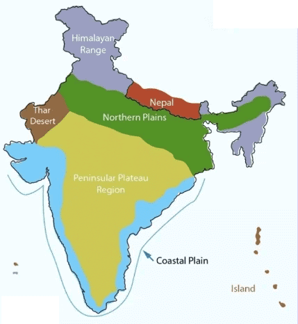
Impact of Topography on Climate
a) Locate the Western Ghats and the Himalayas on the map. How do these mountain ranges influence the climate of the surrounding areas? For example, explain their role in the monsoon rainfall distribution or protection from certain winds.
b) Mark the Thar Desert and explain why its flat topography contributes to its arid climate.
Ans:
- Western Ghats: Locate along the western coast. They act as a barrier, causing heavy rainfall on their western slopes during the southwest monsoon by forcing winds to rise and condense, while the Deccan Plateau to the east receives less rain.
- Himalayas: Locate in northern India. They protect the subcontinent from cold desert winds of Central Asia, keeping northern India relatively warmer in winter, and cause orographic rainfall in some areas.
- Thar Desert: Mark in western Rajasthan. Its flat topography offers no barrier to hot, dry winds from the west (e.g., from Arabia), leading to minimal rainfall and an arid climate.
FAQs on Sample Question Paper Class 7 Social Studies Set 2 (Solutions)
| 1. What topics are covered in Class 7 Social Studies Set 2? |  |
| 2. How can students prepare effectively for the Class 7 Social Studies final exam? | |
| 3. What is the importance of studying Social Studies in Class 7? | |
| 4. Are there any recommended study materials for Class 7 Social Studies? | |
| 5. What tips can help students manage their time during the Social Studies exam? | |


