The Peninsular Plateau : Physical Features of India - Class 9 PDF Download
The Peninsular Plateau
The peninsular plateau is a tableland. It is composed of the oldest rocks because it was formed from the drifted part of the Gondwana land. Broad and shallow valleys and rounded hills are the characteristic features of this plateau.

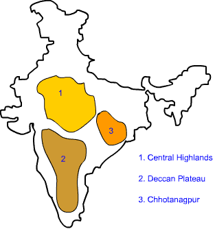
The plateau can be broadly divided into two regions, viz. the Central Highlands and the Deccan Plateau.
- The Central Highlands: The Central Highlands lies to the north of the Narmada river. It covers the major portion of the Malwa plateau. The rivers in this region flow from southwest to northeast; which indicates the slope of this region. It is wider in the west and narrower in the east. Bundelkhand and Baghelkhand mark the eastward extension of this plateau. The plateau further extends eastwards into the Chhotanagpur plateau.
- The Deccan Plateau:- The Deccan Plateau lies to the south of the Naramada river. It is triangular in shape. The Satpura range makes its northern part. The Mahadev, Kaimur Hills and Maikal range make its eastern part. The slope of the Deccan Plateau is from west to east. It extends into the north east which encompasses Meghalaya, Karbi-Anglong Plateau and North Cachar Hills. Garo, Khasi and Jaintia hills are the prominent ranges; starting from west to east.

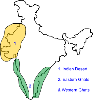
c. The Western and the Eastern Ghats:- They make the western and eastern edges of the Deccan Plateau. The average elevation of Western Ghats is 900 – 1600 metres; compared to 600 metres in case of Eastern Ghats. The Eastern Ghats stretch from Mahanadi Valley to the Nilgiris in the south. The Western Ghats cause oceanographic rains as they face the rain-laden winds from west.
The Indian Desert:-
The Indian desert lies towards the western margins of the Aravali Hills. This region gets scanty rainfall which is less than 150 mm in a year. Hence they climate is arid and vegetation is scanty. Luni is the only large river but some streams appear during rainy season. Crescent-shaped dunes (barchans) abound in this area.
The Coastal Plains
The Peninsular plateau is flanked by stretch of narrow coastal strips. They run along the Arabian Sea on the west and along the Bay of Bengal on the east. The western coast lies between the Western Ghats and the Arabian Sea. It is divided into three sections. The Konkan; which comprises of Mumbai and Goa makes the northern part. The Kannada Plain makes the central pat and the Malabar coast makes the Malabara coast.

The western coastal plain is wider and level and it runs along the Bay of Bengal. It is divided into two parts. The northern part is called Northern Circar. The southern part is called the Coromandel Coast. Extensive deltas are formed by large rivers like Mahanadi, Godavari and Kavery. Chilika lake is an important feature along the eastern coast.
The Islands
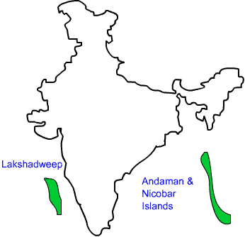
The Lakshadweep Islands are in the Arabian Sea. Its area is 32 sq km. The administrative headquarters of Lakshadweep is at Kavaratti island. This group of islands is rich in terms of biodiversity.
The Andaman and Nicobar Islands are bigger in size and has more number of islands. This group of islands can be divided into two groups. The Andaman is in the north and the Nicobar is in the south. These islands too have rich biodiversity.
FAQs on The Peninsular Plateau : Physical Features of India - Class 9
| 1. What is the Peninsular Plateau? |  |
| 2. What are the physical features of the Peninsular Plateau? |  |
| 3. How was the Peninsular Plateau formed? |  |
| 4. What is the significance of the Peninsular Plateau? |  |
| 5. What are some of the major cities located on the Peninsular Plateau? |  |


