Physical Geography of India


The best source to study Geography for UPSC is NCERT Textbooks from Standard 6 to 12. Most of the topics are explained in very simple language in the basic textbooks and it's really helpful for the exam. We have summarized NCERT and top suggested books for UPSC and have created this Guide on Physical Geography for IAS Aspirants.
Physiographic Divisions of India
- The Earth and its landforms that we see today have evolved over a very long time. Current estimates show that the Earth is approximately 4.6 billion years old.
- Over this long period, it has undergone many changes brought about primarily by the endogenic and exogenic forces.
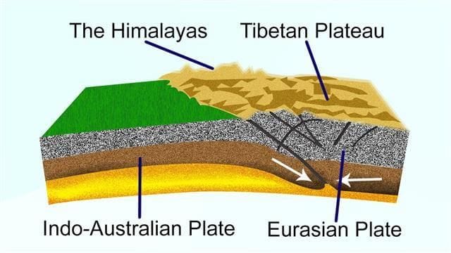
- It is primarily through the interplay of these forces and the movements of the plates that the present geological structure and geomorphologic processes active in the Indian subcontinent came into existence.
What is Physiography?
"Physiography" of an area is the outcome of structure, process, and stage of development. Indian physiography has vast diversity, with the North having rugged topography (mountain ranges, peaks, valleys, deep gorges) and the South has stable lands (dissected plateaus, denuded rocks, series of scarps). The North Indian Plain lies between the north and the south.
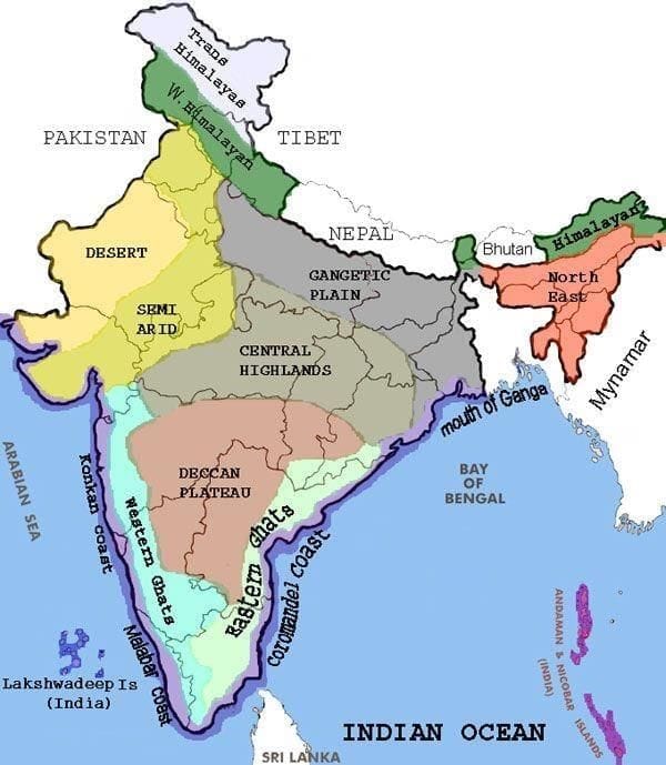
Based on these macro variations, India is divided into the following Physiographic divisions:
- The Northern and North-Eastern Mountains
- The Northern Plain
- The Peninsular Plateau
- The Indian Desert
- The Coastal Plains
- The Islands
Watch the Video on Physiographic Divisions of India to understand the Physiography of India better.
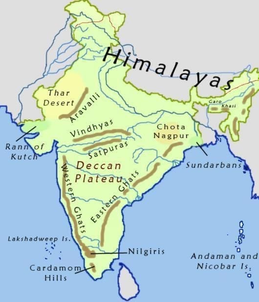 Physiographic divisions of India
[Question: 484356]
The North and North-Eastern Mountains of India
This consists of the Himalayas, the Trans Himalayas, and the North-Eastern Hills.
The Himalayan Region of North India
- The Himalayas are a group of parallel ranges of fold mountains.
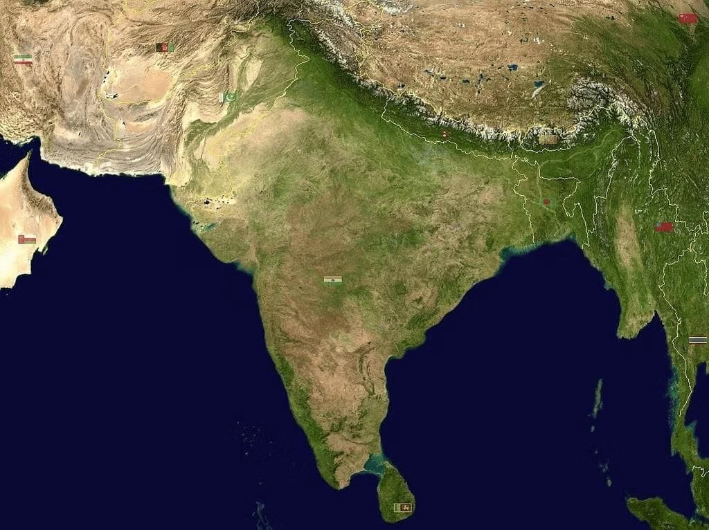
 Location of the Himalayas on Earth
 - They are a strong, long wall between India and Central and East Asian countries. They act as a physical barrier and also as a climatic, drainage, and cultural divide.
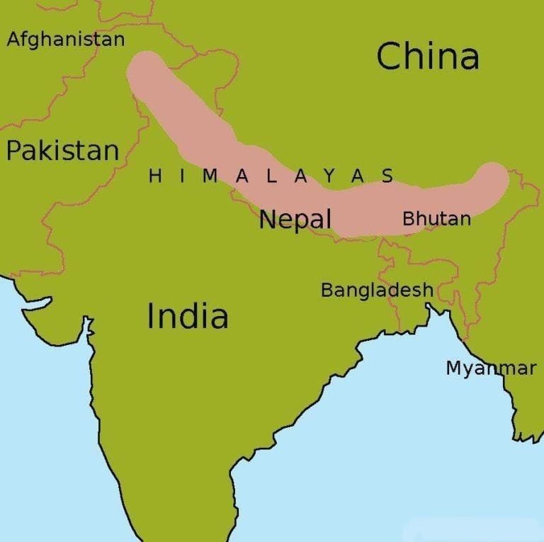 The Himalayas
 - It is classified horizontally into the ranges of:
(i) Greater Himalayas or Himadri
(ii) Middle/Lesser Himalayas or Himachal
(iii) Shivaliks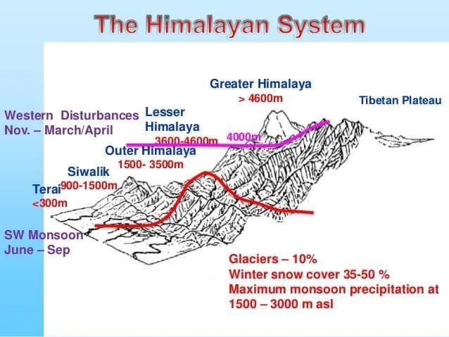 Regionally, the Himalayas can be further divided into:
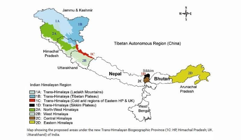
(i) Kashmir or North-western Himalayas
(ii) Himachal and Uttarakhand Himalayas
(iii) Darjeeling and Sikkim Himalayas
(iv) Arunachal Himalayas
(v) Eastern Hills and Mountains
The Trans Himalayan Region of North India
- These mountains lie north of the Great Himalayan range and contain some of the highest mountain peaks in the world such as K2, Nanga Parbat, and Gasherbrum. Major rivers such as the Indus and Brahmaputra originate from these mountains. Much of the range is in Tibet and hence they are also called Tibetan Himalayas.
- The Trans Himalayas consists of 4 main mountain ranges:
(i) Karakoram Range
(ii) Ladakh Range
(iii) Zaskar Range
(iv) Kailas Range
The North-Eastern Hills
- These are the southward extensions of the Himalayas running along the north-eastern edge of India. It straddles across the India-Myanmar border. The Patkai Bum, Naga Hills, and Mizo Hills are the main hill ranges.
Have a look at the Mind Map: The Himalayas to get an overview of Himalayan Region, and it will help you to remember it better for your exam.
[Question: 484357]
Which states comprise the Northern Plains Region of India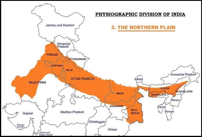
- The northern plains are formed by the alluvial deposits brought by- The Indus, the Ganga, and the Brahmaputra.
- Extension: 3,200 km from east to west.
Width: 150-300 km.
Depth of alluvium deposits: 1,000-2,000 m. - From the north to the south, the Plains can be divided into three major zones:
(i) The Bhabar
(ii) The Tarai
(iii) The alluvial plains ( further divided into the new Khadar and the old Bhangar plains).
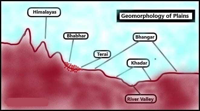 Classification of Northern Plains
- These river valley plains have a fertile alluvial soil cover which supports a variety of crops like wheat, rice, sugarcane, and jute, and hence, supports a large population.
[Question: 484358]
The Peninsular Plateau Region of India
- It rises from a height of 150 m above the river plains up to 600-900 m.
- It has an irregular triangular shape.
- Extension
(i) Delhi ridge in the northwest (extension of the Aravalli Range).
(ii) The Rajmahal hills in the east.
(iii) Gir Range in the west.
(iv) The Cardamom Hills in the south. - The Peninsular Region is made up of a number of patland plateaus ( A Patland plateau or Pat is the local name for lava- capped tablelands) such as the Hazaribagh plateau, the Palamu plateau, the Ranchi plateau, the Malwa plateau, the Coimbatore plateau, and the Karnataka plateau.
- It is one of the oldest and the most stable landmasses of India.
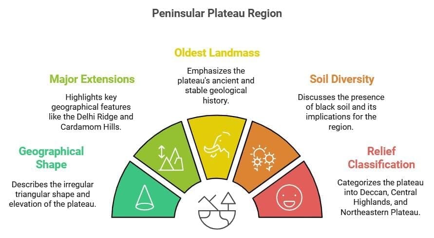
- The western part is loftier than the eastern part.
- The western and northwestern part of the plateau has black soil.
- There is diversity in the relief of the Peninsular plateau: Its northwestern part has a complex relief of ravines and gorges.
Example: The ravines of Chambal, Bhind, etc. - Based on its relief features, the Peninsular plateau can be classified into three groups:
(i) The Deccan Plateau
(ii) The Central Highlands
(iii) The Northeastern Plateau.
What is the Deccan Plateau?
Extent
- The Western Ghats in the west, the Eastern Ghats in the east, the Satpura, the Maikal range, and the Mahadeo hills in the north.
The Western Ghats
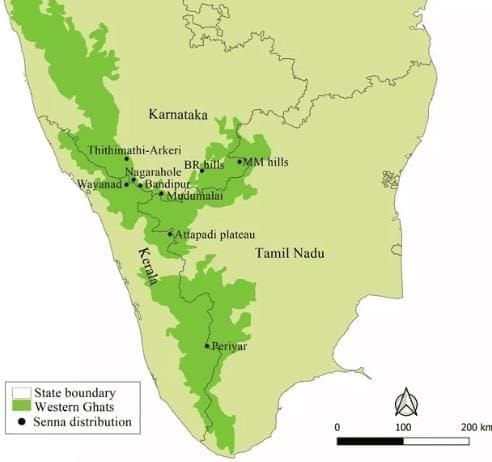
- Locally known by different names such as Sahyadri in Maharashtra, Nilgiri hills in Karnataka and Tamil Nadu and Anaimalai hills and Cardamom hills in Kerala.
- They are higher in elevation and are more continuous than the Eastern Ghats.
- Average elevation: 1,500 m (height increases from north to south)
- 'Anaimudi' (2,695 m) is the highest peak of the Peninsular plateau and is located on the Anaimalai Hills of the Western Ghats.
- Most of the Peninsular rivers have their origin in the Western Ghats.
The Eastern Ghats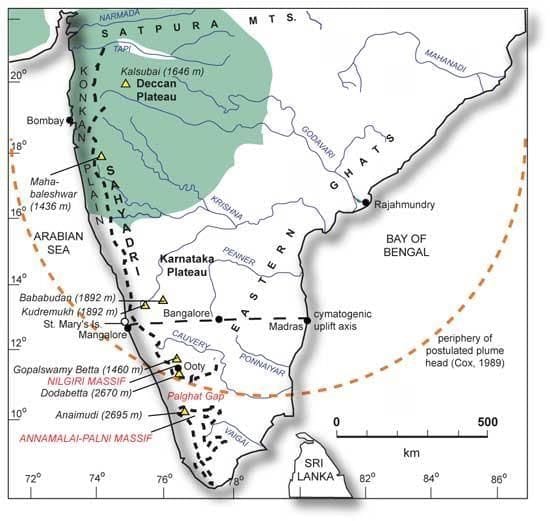
- It consists of discontinuous and low hills which are highly eroded by the rivers such as the Mahanadi, the Godavari, the Krishna, the Kaveri, etc.
- Important ranges: The Javadi hills, the Palconda range, the Nallamala hills, the Mahendragiri hills, etc.
- The Eastern and the Western Ghats meet each other at the Nilgiri hills.
The Central Highlands
- They are bounded by the Aravali range in the West, the Satpura range in the South, and the Rajmahal Hills in the East.
- These are relict mountains that are highly denuded and form discontinuous ranges.
- This region has metamorphic rocks such as marble, slate, gneiss, etc.
- Elevation: 700-1,000 m above the mean sea level.
Northeastern Plateau
- It consists of the Chotanagpur Plateau and the Meghalaya Plateau.
- It is densely forested and populated by many tribal groups.
- The region is rich in mineral resources such as coal, iron, manganese, etc.
- The Meghalaya Plateau is an extension of the main Peninsular plateau and it is believed that a huge fault was created between the Rajmahal hills and the Meghalaya plateau when the Himalayas were formed.
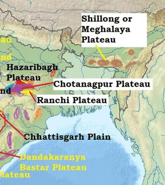
- Later, this depression got filled up by the deposition activity of the many rivers. Today, the Meghalaya and Karbi Anglong plateau stand detached from the main Peninsular Block.
- The Meghalaya plateau is further subdivided into:
(i) The Garo Hills
(ii) The Khasi Hills
(iii) The Jaintia Hills, which are named after the tribal groups inhabiting this region. - The Meghalaya plateau is also rich in mineral resources like coal, iron ore, sillimanite, limestone, and uranium.
- This area receives maximum rainfall from the southwest monsoon. Thus, the Meghalaya plateau has a highly eroded surface. Mawsynram and Cherrapunji in Meghalaya are the wettest places in India.
FAQs related to Physical Geography of India for UPSC
- Is Physical Geography important for UPSC?
In terms of the UPSC civil services test, geography is an essential topic. The UPSC prelims and mains examinations include it. Geography is another optional topic provided by the commission, and it is a hugely popular choice in terms of numbers. - What is India's Physical Geography?
India's topography is incredibly diversified, with snow-capped mountain ranges, deserts, plains, hills, and plateaus among its landscapes. The Indian Plate, which is the northernmost section of the Indo-Australian Plate, is home to the majority of the Indian subcontinent. - What subjects are studied under Physical Geography?
In contrast to the cultural or constructed environment, which is the realm of human geography, physical geography is a field of natural science that deals with processes and patterns in the natural environment, such as the atmosphere, hydrosphere, biosphere, and geosphere.
The Indian Desert / Marusthali Region
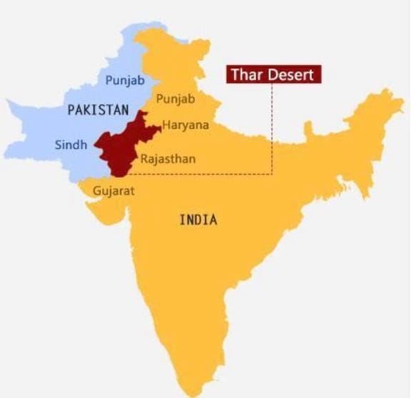 Thar Desert
- The Great Indian Desert or the Thar Desert lies to the northwest of the Aravalli hills.
- It is a land of undulating topography with longitudinal sand dunes and barchans (crescent-shaped dunes).
- It receives below 50 mm precipitation per year and thus has an arid climate with low vegetation cover.
- The underlying rock structure of the desert is an extension of the Peninsular plateau.
- Most of the rivers in this region are ephemeral. The Luni river flowing in the southern part of the desert empties into a dry inland basin and thus is an example of an endorheic river basin.
- Endorheic basin- Sometimes streams disappear into the ground after flowing for some distance, resulting in inland drainage by joining a lake or playa.
[Question: 484363]
The Coastal Plains
- India has a long coastline of about 7516.6 km.
- On the basis of the location and active geomorphological processes, it can be broadly divided into two:
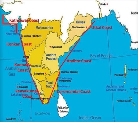 The Coastal Plains of India
(a) Western Coastal Plains
- These are submerged coastal plains with wider continental shelf.
- This submergence has resulted in a narrow coastal belt and provides natural conditions for the development of ports and harbours.
- Kandla, Mazagaon, Kochin, etc. are some of the important natural ports located along the west.
- Extending from the Gujarat coast in the north to the Kerala coast in the south, the western coast may be divided into the following divisions - The Kachchh and Kathiawar coast in Gujarat, the Konkan coast in Maharashtra, Goa and Karnataka, and the Malabar coast in Kerala. The Karnataka coastal plain is also known as Kanara coast.
- The rivers here are fast-flowing and carry less sediments, thus they do not form any deltas.
- The Malabar coast has got certain distinguishing features in the form of 'Kayals'(backwaters), which are used for fishing, inland navigation and also due to its special attraction for tourists.
(b) Eastern Coastal Plains
- These are emergent coast plains.
- The Eastern coastal plain is broader than the Western coastal plain.
- They have well-developed deltas that are formed by the rivers flowing eastward into the Bay of Bengal.
- Example: deltas of the Mahanadi, the Godavari, the Krishna and the Kaveri.
- It has less number of ports and harbours because of its emergent nature.
- The continental shelf here is narrow.
[Question: 484364]
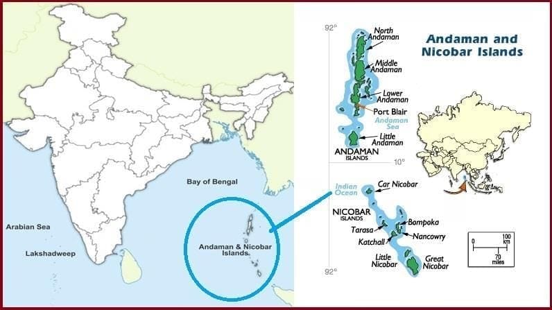
The Islands
There are two major island groups in India :
(a) In the Bay of Bengal
- It includes the Andaman and Nicobar Islands.
- These island groups consist of about 572 islands/islets. These are situated roughly between 6°N - 14°N and 92°E - 94°E.
- The entire group of islands is divided into two broad categories:
(i) The Andaman in the North
(ii) The Nicobar in the South
They are separated by a water body called the Ten-degree channel. - These islands are believed to be an elevated portion of submarine mountains.
- Some smaller islands are volcanic in origin. Barren Island, the only active volcano in India is also situated in the Andaman Islands.
- Baratang island is the only place in India with mud volcanoes.
- The coastline has some coral deposits and beaches.
- These islands receive convectional rainfall and have an equatorial type of vegetation.
 Andaman and Nicobar Islands
(b) In the Arabian sea
- These Islands include Lakshadweep Islands.
- These are scattered between 8°N-12°N and 71°E -74°E longitude and are located at a distance of 280 km-480 km off the coast of Kerala.
- The entire island group is built of coral deposits.
- There are approximately 36 islands of which 11 are inhabited.
- Largest Island: Minicoy (453 sq. km).
- The entire group of islands is broadly divided by the Eleventh-degree channel.
- North of the Eleventh-degree channel is the Amini Island group and to the south is the Kannur Island group.
- The Islands of this archipelago have storm beaches consisting of unconsolidated pebbles, shingles, cobbles and boulders.
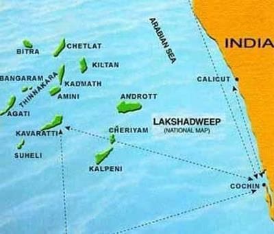 Lakshadweep Island
[Question: 484365]
Mains Questions
1) What is physiography? What are the physiographic divisions of India? (250 words)
How to approach
- Intro- Define physiography and draw the map of India with the physical divisions.
- Body- Explain the divisions in detail separately.
- Conclusion- Two sentences about the significance of such geographical diversity.
