Very Short Answer Questions: India and Her Neighbours

Q1: Which countries are India's land-based neighbours?
Ans: India's land-based neighbours are Pakistan, Afghanistan, China (Tibet region), Nepal, Bhutan, Bangladesh, and Myanmar. These countries share direct land boundaries with India.
Q2: What is the total length of India's land borders?
Ans: India's land borders stretch over 15,100 kilometres. These borders pass through deserts, plains, forests, mountains, marshes, and river valleys across different geographical features.
Q3: What is the length of India's coastline?
Ans: India has a long coastline of about 11,100 kilometres along three sides of the country. This gives India a strong maritime position in the region.
Q4: Name three maritime neighbours of India.
Ans: Three of India's maritime neighbours are Sri Lanka, the Maldives, and Indonesia. These countries are connected to India by shared seas or oceans without direct land borders.
Q5: Which Indian states share a border with China?
Ans: The Indian states that share a border with China are Arunachal Pradesh, Sikkim, Uttarakhand, Himachal Pradesh, and Ladakh. The border runs across the Himalayas.
Q6: How does Buddhism connect India and China culturally?
Ans: Buddhism spread from India to China around the 1st century CE through trade and pilgrimage. Chinese monks like Faxian and Xuanzang travelled to India to study Buddhism.
Q7: What does India export to China?
Ans: India exports iron ore, chemicals, and cotton yarn to China. In return, India imports electronics and industrial equipment from China for its industries.
Q8: When was Pakistan created, and why is it significant?
Ans: Pakistan was created in 1947 during the Partition of India, a legacy of the colonial era. It was founded on a religious basis, unlike India.
Q9: What is the Kartarpur Corridor?
Ans: The Kartarpur Corridor is a visa-free border crossing between India and Pakistan. It allows Indian pilgrims to visit Gurdwara Darbar Sahib, the final resting place of Guru Nānak Dev.
Q10: When was Bangladesh born, and what was it called earlier?
Ans: Bangladesh was born in 1971 as the outcome of a war between India and Pakistan. It was earlier called East Pakistan before gaining independence.
Q11: Which Indian states share a border with Bangladesh?
Ans: The Indian states that share a border with Bangladesh are West Bengal, Assam, Meghalaya, Tripura, and Mizoram. This border is longer than India's border with China.
Q12: What is the Sundarban National Park, and where is it located?
Ans: The Sundarban National Park is the largest mangrove forest in the world and a UNESCO World Heritage Site. About two-thirds lies in Bangladesh and the rest in India.
Q13: What does the 1950 Treaty of Peace and Friendship with Nepal provide?
Ans: The 1950 Treaty provides for open borders and free movement of people and goods between India and Nepal. It also includes cooperation in defence and foreign policy.
Q14: Why is Bhutan called the 'Land of the Thunder Dragon'?
Ans: Bhutan is called 'Drukyul' or 'Land of the Thunder Dragon' by its inhabitants. The dragon on Bhutan's emblem symbolises the thunderous voice of the Buddha's teachings.
Q15: What is the Gross National Happiness Index?
Ans: Bhutan developed the Gross National Happiness Index as a more holistic measure of progress compared to Gross Domestic Product. It includes sustainability, good governance, and promotion of culture.
Q16: Which Indian states share a border with Myanmar?
Ans: India's northeastern states that share borders with Myanmar are Arunachal Pradesh, Nagaland, Manipur, and Mizoram. Myanmar also shares a maritime boundary with India in the Bay of Bengal.
Q17: What was the ancient Uttarāpatha trade route?
Ans: The Uttarāpatha was an ancient trade route linking the Ganga plains to Central Asia via Afghanistan. It stretched from Gandhāra through Takṣhaśhilā, Varanasi, and Pāṭaliputra.
Q18: What were the Buddhas of Bamiyan?
Ans: The Buddhas of Bamiyan were gigantic statues in Afghanistan and symbols of Mahāyāna Buddhism. They were destroyed in 2001 after standing for many centuries.
Q19: When was SAARC formed, and what are its aims?
Ans: The South Asian Association for Regional Cooperation (SAARC) was formed in 1985 to promote mutual interests and sociocultural and economic progress. It aims to share resources around development.
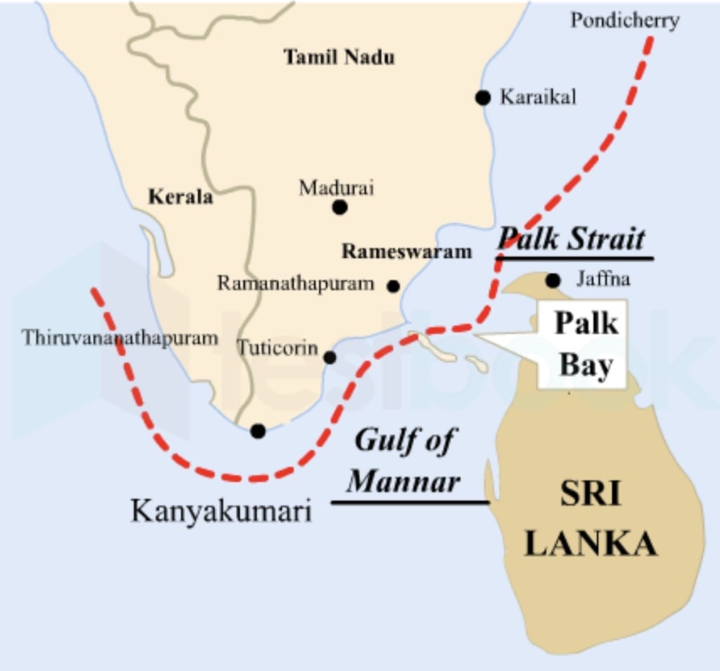
Q20: How is Sri Lanka separated from India?
Ans: Sri Lanka is separated from India by the Palk Strait. At the nearest point, the distance between India and Sri Lanka is only about 32 kilometres.
Q21: What cultural influences does the Maldives show from India?
Ans: The Maldives shows influences from Tamil Nadu and Kerala in language, cuisine, and arts. Dishes like coconut curries reflect South Indian flavours, and Boduberu dance echoes Tamil folk rhythms.
Q22: What is the India-Myanmar-Thailand Trilateral Highway?
Ans: The India-Myanmar-Thailand Trilateral Highway stretches from Manipur through Myanmar into Thailand. It improves overland connectivity, trade, and regional cooperation amongst the three countries.
Q23: What is the Borobudur Stūpa?
Ans: The Borobudur Stūpa is the world's largest Buddhist monument, built in stone in the 8th and 9th centuries CE in Indonesia. It has over 500 Buddha statues.
Q24: What is Chabahar Port, and why is it important for India?
Ans: Chabahar Port is located in Iran, and India is helping develop it. This port gives India better access to Afghanistan and Central Asia for trade and transport.
Q25: How are India and Oman historically connected?
Ans: People-to-people contact between India and Oman dates back over 5,000 years to the time of the Indus or Harappan civilisation. Harappan traders brought back copper ingots from Oman.
FAQs on Very Short Answer Questions: India and Her Neighbours
| 1. What are the main countries that share borders with India? |  |
| 2. How does the geography of India influence its relationships with neighbouring countries? | |
| 3. What role does water play in India's relations with its neighbours? | |
| 4. How has historical conflict shaped India's interactions with its neighbours? | |
| 5. What are the cultural ties that India shares with its neighbouring countries? | |


