Veena Bhargava Textbook Solutions: Interpretation of Topographical Maps - I

Answer the following questions
Q1: How many types of maps are there?Ans: Maps are classified in several ways depending on the purpose for which they are made and the scale at which they are drawn. Two common and useful ways to classify maps are by scale and by function. Each class serves a particular purpose and shows different levels of detail:
- Classification Based on Scale: Maps differ by scale, which determines how much ground is represented on a sheet and how much detail is shown. Large-scale maps cover a small area with a high level of detail and are used for local planning, land records (cadastral maps) and topographical representation of physical features such as contours, roads and buildings. Small-scale maps show vast areas with less detail and are used for regional, national or world representation - examples include atlas sheets and political reference maps. Intermediate or medium-scale maps serve regional planning and resource-management needs.
- Classification Based on Function: Maps are also classified by their purpose. Political maps show administrative boundaries (countries, states, districts). Physical maps emphasise natural features such as mountains, rivers and plains. Thematic maps focus on a particular subject or theme (for example population density, rainfall distribution, soil type or economic activities) and help in studying spatial patterns and relationships. Other functional types include navigational charts, cadastral maps, topographic maps and climatic maps.
Q2: What is the significance of colours in Topographical Maps?
Ans: Colours on topographical maps are conventional and standardised so that map reading is quick and reliable. Each colour represents a class of features, making it easy to recognise different kinds of information at a glance. The commonly used conventional colours and their meanings are:
- Blue: Water features such as rivers, lakes, ponds, wells and perennial streams.
- Brown: Contours and other relief information that show elevation and shape of landforms.
- Black: Cultural and man-made features like buildings, surveyed trees, railways, dry streams and some track lines.
- Green: Vegetation such as forests, orchards and plantations.
- Red (or Purple): Important roads, selected administrative boundaries and amendments or revisions on certain editions.
- Yellow: Often used to indicate cultivable or built-up land in some series of maps.
Using these standard colours helps convey multiple layers of information without overcrowding the sheet. For example, a blue line together with brown contours quickly shows a river flowing through a valley; green patches on contours indicate forested slopes. The map legend always confirms the exact meaning of each colour on that sheet.
Q3: List the objectives of the Survey of India map.
Ans: The principal objectives of maps produced and maintained by the Survey of India include:
- To establish and maintain accurate topographical control and to carry out systematic surveys across the country, providing the base data needed for all mapping work.
- To prepare and publish maps for political, physical and navigational purposes, including aeronautical charts that support administration, education, defence and aviation.
- To demarcate and record the external boundaries of the Republic of India clearly and authoritatively for legal and administrative purposes.
- To undertake research and development in cartography, printing and aerial photography so that mapping methods, accuracy and map products are continuously improved.
- To provide reliable base maps for development planning, disaster management, resource assessment and scientific studies.
Q4: Draw the symbols of the following conventional signs in appropriate colours -
- Broken Ground
- Temple
- Church
- Contours showing one side steep, the other side gentle slope
- Surveyed tree
Ans:
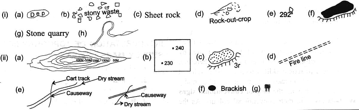
1. Broken Ground: The symbol indicates an irregular or rough surface, often shown as a series of short broken lines or stippling to
represent uneven, eroded or uncultivable land. The conventional colour and exact pattern should be checked in the map legend.
2. Temple: Temples are marked by a cultural symbol (which varies between map series) to indicate a place of worship. The symbol is usually shown in black or red; consult the legend for precise depiction.

3. Church: Churches are commonly represented by a cross-shaped mark or another agreed symbol to denote the building; these are normally shown in black or red on topographical maps.

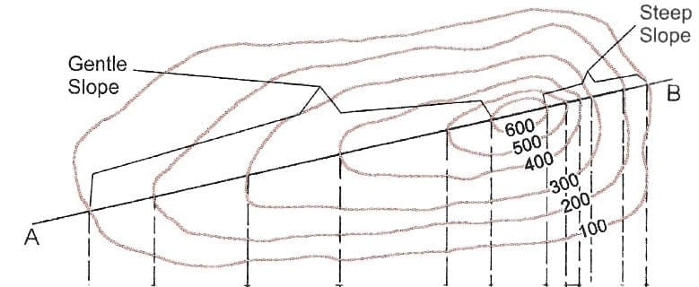
4. Contours showing one side steep, the other side gentle slope: When contours are closely spaced on one side of a ridge or valley and widely spaced on the other side, the close spacing indicates a steep slope while wide spacing indicates a gentle slope. This pattern shows an asymmetrical slope on the ground. On maps, this helps identify escarpments, valley sides and the direction of steepest descent.
5. Surveyed Tree: A surveyed tree is marked by a small black symbol that identifies an individually surveyed and recorded tree used as a fixed reference point in surveying and mapping. Such symbols are useful as local control points when other permanent marks are absent.

Q5: Define the following terms
- Causeway
- Contours
- Depression
- Stony waste
- Fire line
- Brackish
- Meander
- Broken ground
- Embankment
- Diggi
- Pylons
Ans:
- Causeway: A raised road or track built across low-lying or wet ground and across shallow watercourses, allowing passage during drier periods. Multiple causeways in an area often indicate seasonal water flow or limited rainfall.
- Contours: Brown lines on a map joining points of equal elevation above mean sea level. They show land shape and slope; the closer the contours, the steeper the slope.
- Depression: A sunken or lowered area of land. On maps a depression is shown by closed contours with short inward-pointing ticks (hachures) to indicate lower ground within the closed loop.
- Stony Waste: Land largely covered by stones and rocks where cultivation is not possible; represented on maps by a distinct symbol or shading indicating rocky terrain.
- Fire Line: A cleared strip in forested areas made to halt or slow the spread of wildfire by removing combustible material.
- Brackish: Water that is slightly salty, typically found in wells or ponds near coasts; not suitable for drinking or irrigation without treatment.
- Meander: A pronounced bend or curve in a river, usually formed in the river's middle course where the gradient is gentle and lateral erosion is dominant.
- Broken Ground: Rough, uneven terrain often shown by special symbols; it may result from erosion, gullies or rocky outcrops and is generally uncultivable.
- Embankment: A constructed bank of earth or stone along a road, railway or watercourse to prevent flooding or to carry the route above flood level.
- Diggi: A local tank or small reservoir constructed to collect and store surface water for domestic use, livestock or irrigation.
- Pylons: Tall support structures carrying overhead electric transmission lines; marked on maps to indicate the route of high-voltage lines.
Q6: What is the significance of conventional signs and symbols in topographical survey maps? Explain with the help of examples.
Ans: Conventional signs and symbols serve as a standard shorthand so that maps can convey a large amount of information without lengthy text. Their main advantages are rapid recognition by users, reduced clutter on the map sheet and consistent meaning across map sheets when the legend is followed.
Examples include:
- Settlements shown by red or black solid shapes quickly identify inhabited places and their relative size.
- Hospitals indicated by a red plus sign allow easy spotting of medical facilities in an emergency.
- Standard symbols for aerodromes, post offices, police stations, places of worship, water tanks and bridges help planners, travellers and students locate services and infrastructure fast.
Because these symbols are agreed conventions, maps produced by different agencies remain usable without re-learning the signs; the map legend confirms exact depictions used for that sheet.
Q7: Define the following conventional signs and symbols and explain in brief.
Ans:
- Depression: A lowered area of ground shown by closed contours with short inward-pointing ticks (hachures) where the centre is lower than the surrounding ground.
- Stony Waste: Rocky land unsuitable for cultivation, usually shown as an uncoloured or specially marked patch indicating sparse soil cover.
- Sheet Rock: A broad area where bedrock is exposed over a wide surface and soil is thin or absent; marked to show poor agricultural potential.
- Rock-out-Crop: Locations where bedrock appears at the surface; indicated to show exposed rock and limited soil depth.
- Surveyed Tree: A prominent tree recorded as a fixed survey point; shown with a small black symbol and used as a reference in mapping.
- Embankment: A built bank of earth or stone along a channel or road to prevent overflow and to keep the route above flood level; its relative height may be noted.
- Stone Quarry: An area where stone is extracted; marked to indicate an industrial activity and specific land use.
- Meander: A large curve in a river channel, formed where the river flows over flat terrain and lateral erosion is more active than vertical erosion.
- Ridge: A long, narrow elevated crest of land that often serves as a watershed dividing different drainage basins.
- Spot Height: A precise elevation of a particular point given on the map. For example, .240 indicates that the point is 240 metres above mean sea level.
- Relative Height: The height difference between two nearby features, such as the height of an embankment above the surrounding ground.
- Fire Line: A cleared strip in forested areas where vegetation has been removed to check the spread of fires.
- Causeway: A raised track across wet or shallow water that is often motorable only in dry conditions; shown to indicate seasonal crossing points.
- Brackish: Water with noticeable salt content (not suitable for drinking or irrigation without treatment); marked near coastal wells or ponds.
- Overhead Tank: A raised water storage facility serving nearby settlements; indicated to show public water supply infrastructure.
FAQs on Veena Bhargava Textbook Solutions: Interpretation of Topographical Maps - I
| 1. What are topographical maps? |  |
| 2. How do contour lines work on a topographical map? | |
| 3. What is the significance of scale in topographical maps? | |
| 4. How can one identify landforms using a topographical map? | |
| 5. What other information can be found on topographical maps besides elevation? | |


