Practice Questions :Agriculture and Rural Land-Use Patterns and Processes

SECTION I: MULTIPLE CHOICE
Directions
Select the best answer for each question. You have approximately 30 minutes to complete this section. Each question is worth 1 point.
Questions 1-3 refer to the following data table.
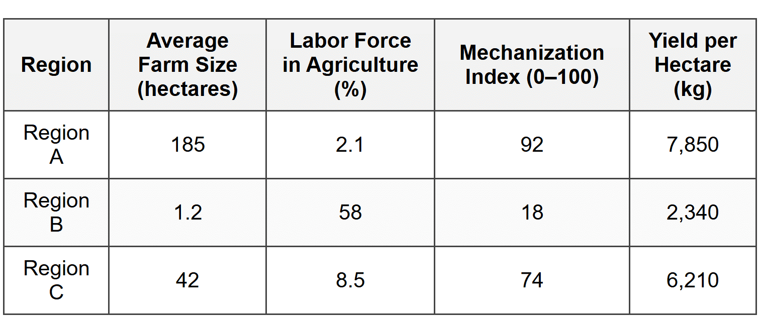
1. Based on the data in Table 1, which region most likely represents a subsistence agricultural system?
- Region A, because of its high yield per hectare indicating intensive farming practices
- Region B, because of its small farm size and high percentage of labor force in agriculture
- Region C, because it shows a balance between mechanization and labor input
- Region A, because large farm sizes require more family labor to maintain production
2. The mechanization index and labor force percentage in Region A best illustrate which of the following agricultural characteristics?
- Pastoral nomadism requiring minimal technology but extensive land use
- Capital-intensive commercial agriculture with high technological inputs
- Shifting cultivation relying on traditional labor-intensive methods
- Plantation agriculture dependent on large manual labor forces
3. A geographer analyzing Table 1 would most likely conclude that Region B faces which of the following challenges?
- Overproduction due to excessive mechanization leading to crop surplus
- Rural-to-urban migration caused by agricultural labor surplus
- Low agricultural productivity due to limited access to technology and capital
- Environmental degradation from intensive chemical fertilizer application
Questions 4-5 refer to the following information.
The model proposes concentric rings of agricultural activity surrounding a central market city. The type of agriculture practiced in each ring is determined by transportation costs, land rent, and the perishability of products. The rings, from innermost to outermost, traditionally include: intensive market gardening and dairy, forest for fuel and construction, grains and field crops, ranching and livestock.
4. Which of the following modern developments has most significantly reduced the applicability of Von Thünen's model in more developed countries?
- Increased global population growth requiring more intensive agricultural production near cities
- Improvements in refrigeration and transportation technology allowing perishable goods to travel longer distances
- Climate change causing shifts in optimal crop-growing regions toward city centers
- Government agricultural subsidies that encourage farmers to locate closer to urban markets
5. A geographer observes that intensive dairy farming occurs 300 kilometers from a major city, while grain production occurs within 50 kilometers of the city center. This pattern represents a departure from Von Thünen's model most likely explained by which of the following?
- The city has no demand for dairy products due to dietary preferences
- Physical geography such as climate and soil quality overrides economic factors in determining land use
- Government land-use regulations prohibit dairy farming near urban areas
- Transportation costs for grain are higher than for dairy products in this region
Questions 6-8 refer to the following data table.
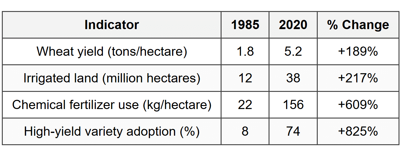
6. The data in Table 2 best illustrate the effects of which agricultural revolution in Country X?
- The First Agricultural Revolution, characterized by the domestication of plants and animals
- The Second Agricultural Revolution, characterized by mechanization and crop rotation
- The Green Revolution, characterized by high-yield varieties and increased chemical inputs
- The Third Agricultural Revolution, characterized by biotechnology and genetically modified organisms
7. Based on the trends shown in Table 2, Country X would most likely experience which of the following environmental challenges?
- Decreased soil erosion due to reduced tillage from high-yield crop varieties
- Water table depletion and nutrient runoff from increased irrigation and fertilizer use
- Reduced biodiversity due to expansion of organic farming practices
- Increased carbon sequestration from intensive agricultural chemical application
8. The dramatic increase in high-yield variety adoption shown in Table 2 would most likely result in which of the following socioeconomic changes in Country X?
- Increased food security but potential widening of the wealth gap between large and small farmers
- Decreased agricultural productivity leading to higher food import dependence
- Elimination of rural poverty through equal distribution of agricultural technology
- Complete transition from commercial to subsistence farming in rural areas
9. Which of the following best explains why Mediterranean agriculture is characterized by diverse crops including olives, grapes, and citrus fruits?
- Government subsidies encourage crop diversification to stabilize farm incomes
- The hot, dry summers and mild, wet winters create ideal conditions for drought-resistant perennial crops
- High population density requires intensive production of multiple crop types on small plots
- Poor soil quality necessitates rotating between different crop species each season
Questions 10-11 refer to the following information.
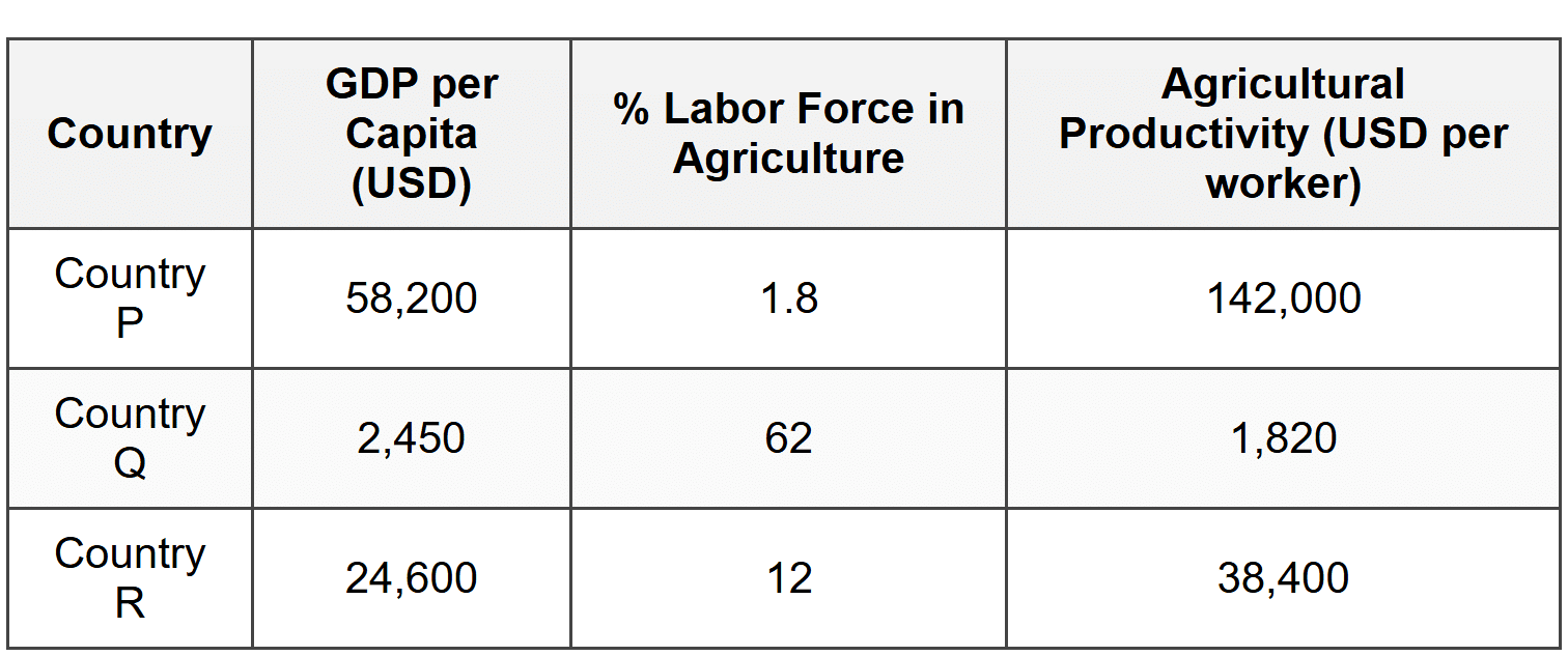
10. The relationship between agricultural labor force percentage and GDP per capita shown in Table 3 best supports which of the following concepts?
- As countries develop economically, a smaller percentage of the labor force is needed in agriculture due to increased mechanization and productivity
- Economic development causes a decline in agricultural productivity requiring more workers to maintain food production
- Wealthy countries import all their food and therefore need no agricultural workers
- Agricultural employment percentage is unrelated to economic development levels
11. A government policy maker in Country Q reviewing Table 3 would most likely prioritize which of the following strategies to increase agricultural productivity?
- Restricting rural-to-urban migration to maintain agricultural labor supply
- Investing in agricultural technology, infrastructure, and education to increase output per worker
- Reducing farm sizes to create more subsistence farming opportunities
- Eliminating all mechanization to preserve traditional farming methods
12. Bid-rent theory explains the spatial arrangement of agricultural activities by analyzing the relationship between which of the following factors?
- Soil fertility and crop yield potential at varying distances from rivers
- Land price, transportation costs, and distance from the market
- Government subsidies and farmer income levels across different regions
- Climate zones and the distribution of agricultural technology
Questions 13-14 refer to the following data.
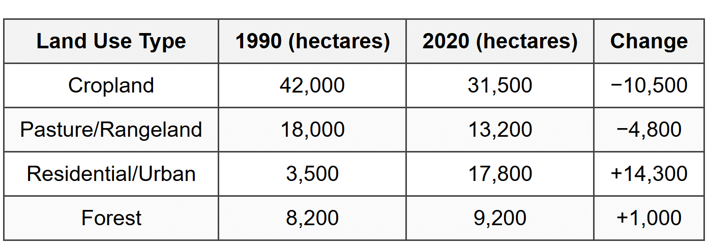
13. The pattern shown in Table 4 is best explained by which of the following processes?
- Agricultural intensification resulting from increased global food demand
- Urban sprawl and suburban expansion converting agricultural land to residential use
- Deforestation driven by the expansion of commercial farming operations
- Rural depopulation causing farmland to return to natural forest cover
14. The changes in County Z shown in Table 4 would most likely result in which of the following challenges for the region?
- Decreased property tax revenue due to declining land values
- Loss of local food production capacity and increased dependence on external food sources
- Improved soil quality from reduced agricultural chemical use
- Elimination of urban-rural conflicts over land use
15. Intensive subsistence agriculture in monsoon Asia is characterized by which of the following practices?
- Large mechanized farms producing grain for export to global markets
- Small plots with high labor inputs producing rice primarily for family consumption
- Nomadic herding of livestock across extensive grassland regions
- Shifting cultivation with long fallow periods to restore soil fertility
Questions 16-17 refer to the following information.
A commodity chain traces the sequence of activities involved in producing and distributing a product from creation to end consumer. For coffee, this includes: cultivation by small farmers in less developed countries → processing and hulling → export through international brokers → roasting and packaging by multinational corporations in more developed countries → distribution to retail outlets → consumer purchase.
16. The commodity chain for coffee described above best illustrates which of the following geographic concepts?
- Vertical integration, where a single company controls all stages of production and distribution
- Spatial division of labor, where different stages of production occur in different locations based on comparative advantage
- Economies of scale, where larger farms produce coffee more efficiently than smaller farms
- Agricultural subsidy systems, where governments support farmers at each stage of the commodity chain
17. Small coffee farmers in less developed countries often receive a small fraction of the final retail price. Which of the following strategies has been developed to address this economic inequality in agricultural commodity chains?
- Free trade agreements that eliminate all tariffs on agricultural products
- Fair trade certification programs that guarantee minimum prices and direct market access for producers
- Government subsidies for large commercial farms to increase production efficiency
- Mechanization programs to reduce labor costs in coffee cultivation
18. Which of the following best explains why pastoral nomadism is primarily practiced in arid and semi-arid regions?
- These regions have the highest market prices for livestock products
- Environmental conditions are unsuitable for crop cultivation, making animal herding the most viable agricultural strategy
- Government policies in these regions prohibit crop farming
- Pastoral nomadism requires large amounts of rainfall to sustain livestock
Questions 19-20 refer to the following data.
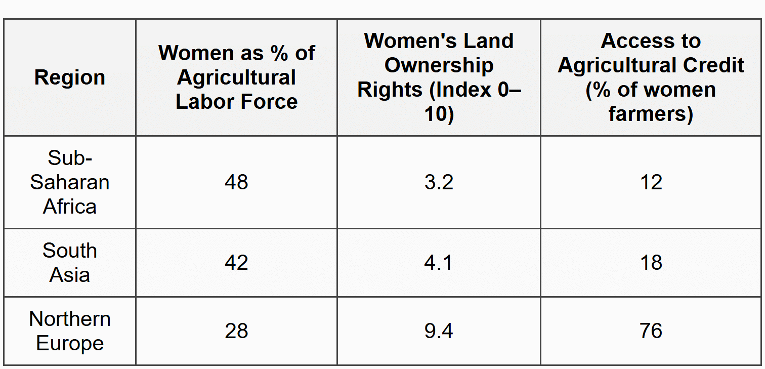
19. The data in Table 5 best support which of the following conclusions about gender and agriculture?
- Women's participation in agricultural labor is highest in regions where they have the strongest legal and economic rights
- Despite high participation rates in agricultural labor, women in Sub-Saharan Africa and South Asia face significant barriers to land ownership and credit access
- Mechanization in Northern Europe has eliminated the need for female agricultural labor
- Women in all regions have equal access to agricultural resources regardless of participation rates
20. A development organization seeking to improve agricultural productivity in Sub-Saharan Africa should prioritize which of the following interventions based on the data in Table 5?
- Reducing women's participation in agricultural labor to focus on urban employment
- Strengthening women's land ownership rights and improving access to agricultural credit and resources
- Encouraging migration from rural to urban areas to reduce agricultural population
- Promoting traditional gender roles that restrict women's participation in farming decisions
SECTION II: FREE RESPONSE
Directions
Answer both questions in this section. Use complete sentences and appropriate geographic terminology. Read each question carefully and respond to all parts of each question. Use approximately 25 minutes for each question.
Question 1
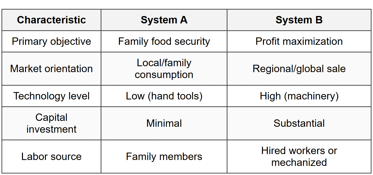
- Define the type of agricultural system represented by System A.
- Explain how the level of economic development in a country influences which agricultural system (A or B) is more prevalent.
- Analyze one environmental consequence of large-scale adoption of System B in regions that previously practiced System A, using a specific example from a region that has undergone this transition.
Question 2
Rural settlements are distributed across landscapes in distinctive patterns that reflect environmental, historical, and cultural factors. Clustered settlements concentrate homes and buildings in a central location with surrounding agricultural fields. Dispersed settlements feature isolated farmsteads separated by fields with no central village. Linear settlements arrange buildings along a transportation route or physical feature such as a road, river, or coastline.
- Identify the type of rural settlement pattern that would most likely develop in a region where cooperative farming and shared resources are culturally important.
- Explain how transportation infrastructure influences the development of linear settlement patterns in rural areas.
- Evaluate the advantages and disadvantages of dispersed settlement patterns for agricultural productivity and quality of life, using specific examples from rural areas in the United States or Canada.
ANSWER KEY
Part A: Multiple Choice Answer Key
Part B: Free Response Answer Key
FRQ 1 - Answer Key
Part A: Define the type of agricultural system represented by System A.
System A represents subsistence agriculture. Subsistence agriculture is a farming system in which agricultural production is primarily intended to feed the farmer's family directly, with little or no surplus for sale in markets. This system is characterized by small-scale operations, minimal capital investment, low technology levels using hand tools and animal labor, and reliance on family labor rather than hired workers. The primary goal is food security for the household rather than profit generation. Subsistence agriculture is most common in less developed countries, particularly in regions of Sub-Saharan Africa, South Asia, and Southeast Asia, where smallholder farmers cultivate plots often smaller than 2 hectares using traditional methods passed down through generations.
Part B: Explain how the level of economic development in a country influences which agricultural system (A or B) is more prevalent.
The level of economic development strongly influences the prevalence of agricultural systems through multiple interconnected mechanisms. In less developed countries, System A (subsistence agriculture) dominates because limited access to capital prevents farmers from investing in machinery, improved seeds, and chemical inputs. Low levels of industrialization mean few employment opportunities outside agriculture, keeping large percentages of the population engaged in farming for survival. Poor infrastructure such as unpaved roads and limited storage facilities makes it difficult and expensive to transport products to distant markets, reducing incentives for commercial production. Additionally, land tenure systems and small average farm sizes limit economies of scale.
In more developed countries, System B (commercial agriculture) predominates because high capital availability allows farmers to invest in advanced machinery such as tractors, combines, and GPS-guided equipment. Mechanization dramatically increases labor productivity, meaning fewer workers can cultivate larger areas, freeing most of the population to work in secondary and tertiary economic sectors. Well-developed infrastructure including refrigerated transport, grain elevators, and efficient supply chains enables farmers to reach distant markets profitably. Strong credit systems, agricultural extension services, and research institutions support continuous technological innovation. Government policies often encourage large-scale commercial farming through subsidies and price supports. For example, in the United States, less than 2% of the labor force works in agriculture, yet the country is one of the world's largest agricultural exporters, exemplifying the capital-intensive commercial model.
Part C: Analyze one environmental consequence of large-scale adoption of System B in regions that previously practiced System A, using a specific example from a region that has undergone this transition.
The transition from subsistence to commercial agriculture often results in significant soil degradation and loss of biodiversity due to intensification practices. One clear example is the Punjab region of India, which underwent rapid agricultural transformation during the Green Revolution of the 1960s-1980s. Previously, farmers in Punjab practiced diverse subsistence agriculture with crop rotation, intercropping, and integration of livestock, which maintained soil organic matter and supported varied ecosystems.
The shift to commercial agriculture introduced high-yield wheat and rice varieties designed for continuous monoculture production, requiring intensive chemical fertilizer application. While yields initially increased dramatically, the environmental consequences became severe. Continuous monoculture depleted soil nutrients not replaced by synthetic fertilizers, particularly micronutrients and organic matter that give soil its structure and water-retention capacity. Heavy fertilizer use killed beneficial soil microorganisms and earthworms that naturally cycle nutrients. The elimination of crop diversity destroyed habitat for beneficial insects, birds, and soil organisms, reducing the agricultural ecosystem's resilience to pests and diseases.
Additionally, intensive irrigation required to support two crops per year has caused water table depletion of over 1 meter per year in some districts, making groundwater increasingly saline and unsuitable for agriculture. Pesticide runoff has contaminated water sources and reduced populations of natural predators, creating dependency on chemical pest control. The Punjab example demonstrates that while commercial agriculture (System B) dramatically increases short-term productivity and farmer income, it often creates long-term environmental degradation that threatens the sustainability of agriculture itself, requiring costly interventions to restore soil health, water resources, and biodiversity that subsistence systems maintained through traditional practices.
FRQ 2 - Answer Key
Part A: Identify the type of rural settlement pattern that would most likely develop in a region where cooperative farming and shared resources are culturally important.
Clustered (nucleated) settlement pattern would most likely develop in regions where cooperative farming and shared resources are culturally important. In clustered settlements, homes and buildings are concentrated in a central village location, with agricultural fields surrounding the settlement core in a radial pattern. This spatial arrangement facilitates social interaction, collective decision-making, and resource sharing among community members. Examples include traditional agricultural villages in medieval Europe where common fields were collectively managed, ejido communities in Mexico where land was communally owned and worked, and kibbutzim in Israel where agricultural production was organized cooperatively. The physical proximity of homes in clustered settlements makes it easier to share equipment, coordinate planting and harvesting schedules, maintain communal facilities such as granaries or irrigation systems, and provide mutual assistance during labor-intensive agricultural periods.
Part B: Explain how transportation infrastructure influences the development of linear settlement patterns in rural areas.
Transportation infrastructure strongly influences linear settlement patterns through the economic principle of accessibility and market access. Linear settlements develop along roads, rivers, canals, or rail lines because these transportation corridors reduce the cost and difficulty of moving agricultural products to markets and obtaining necessary supplies. When a road or navigable river is constructed through rural areas, land values typically increase along the corridor because farmers located there can transport their goods more quickly and cheaply than those located farther away. This creates an economic incentive for farmers to build homes and structures adjacent to the transportation route to minimize the distance they must haul crops.
The pattern becomes self-reinforcing: as settlement density increases along the corridor, services and commercial activities such as equipment dealers, grain elevators, general stores, and processing facilities also locate along the route to serve the farming population. This further increases the economic advantages of locating near the infrastructure. For example, the Saint Lawrence River valley in Quebec exhibits strong linear settlement patterns (called "long lots" or rang system) where farms extend perpendicular to the river, with each farmhouse positioned on the riverbank. This pattern developed because the river was the primary transportation route, providing access to markets in Montreal and Quebec City. Similarly, rural areas of the Canadian Prairies show linear settlement along railway lines constructed in the late 19th century, as farmers needed rail access to ship grain to export terminals. Modern examples include settlement along highways in rural Brazil, where the Trans-Amazonian Highway created linear development as it opened previously inaccessible agricultural frontiers.
Part C: Evaluate the advantages and disadvantages of dispersed settlement patterns for agricultural productivity and quality of life, using specific examples from rural areas in the United States or Canada.
Advantages of dispersed settlement patterns for agricultural productivity: The primary advantage is that direct access to farmland reduces time and energy spent traveling between residence and fields. In the Midwestern United States, such as Iowa and Illinois, the characteristic dispersed pattern of isolated farmsteads allows farmers to monitor crops and livestock constantly, respond quickly to problems such as equipment breakdowns or animal health issues, and efficiently manage large mechanized operations. The farmstead location at the center of the property minimizes the distance equipment must travel, reducing fuel costs and wear. Dispersed settlement also eliminates conflicts over land use that can arise in clustered communities where prime agricultural land near the village may be converted to residential use. Each farmer has direct control over and proximity to their entire property, facilitating independent decision-making about crop selection, management practices, and timing of operations without need for collective coordination.
Disadvantages for quality of life: Dispersed settlement patterns create significant challenges for provision of infrastructure and services. Extending electricity, telephone service, internet connectivity, and paved roads to scattered farmsteads is far more expensive per household than serving concentrated populations. Rural areas of the Great Plains, such as western Kansas and Nebraska, face high costs for maintaining road networks that serve few people per mile. Social isolation is a major quality-of-life issue, particularly for farm families with children who may live many miles from the nearest neighbors, schools, or community facilities. This isolation contributed to rural depopulation in many areas as young people moved to urban areas seeking social interaction and employment opportunities.
Access to services such as emergency medical care, fire protection, and law enforcement is compromised by distance and response time. For example, in rural Montana, ambulance response times can exceed 30 minutes to remote farmsteads, creating health risks. Educational opportunities are limited when school consolidation requires long bus rides; in parts of Saskatchewan, children may spend 2-3 hours per day on school buses traveling to consolidated schools. The dispersed pattern also makes community organization and collective action more difficult, as farmers cannot easily gather for meetings or social activities, weakening community bonds that provide social support and facilitate cooperation on issues of common concern such as water management or marketing.
The overall evaluation depends on context: for large-scale mechanized grain farming characteristic of the North American interior, dispersed settlement maximizes operational efficiency despite social costs. However, as rural populations decline and services become harder to sustain, some regions are experiencing renewed interest in clustered development to create more viable rural communities, particularly as precision agriculture technology reduces the importance of immediate physical proximity to fields.


