Case Based Questions: Locating Places on the Earth

Q1: Read the source and answer the question that follows
Aryan and Meera are on a school trip to a new city. Their teacher gives them a map to find their way around. Aryan notices a small ruler printed at the bottom of the map and asks what it means. The teacher explains that this is called the scale - it helps us understand how a big area fits on a small sheet of paper. She also points to small pictures on the map that show temples, railway stations and roads, and tells them these are called symbols. Meera asks about the arrows at the corner of the map, and the teacher says those show direction - north, south, east and west. The teacher tells them that distance, direction and symbols are the three important parts of every map.
Q1. What are the three main components of a map?
Ans: The three main components of a map are distance, direction and symbols.
Q2. Why are symbols used on a map?
Ans: Symbols are used to show buildings, roads and rivers in a small space on the map, since it is not possible to draw everything in full size.
Q3. What is a book or collection of maps called?
A) Globe
B) Atlas
C) Scale
D) Symbol
Ans: B) Atlas
Q2: Read the source and answer the question that follows
Simran and Rohan are studying the globe in their classroom. Their teacher draws an imaginary line around the middle of the globe and tells them it is called the Equator. She then shows many lines running parallel to the Equator going towards the North Pole and the South Pole. She tells the class these are called parallels of latitude and are measured in degrees. The Equator is at 0° and the poles are at 90°. The teacher also explains that places near the Equator are very hot, places in the middle have a mild climate, and places near the poles are very cold. Simran is surprised to learn that just by knowing the latitude of a place, she can get an idea of its climate.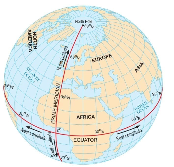
Q1. What is the latitude value of the Equator and the two poles?
Ans: The Equator is at 0° latitude. The North Pole is at 90°N and the South Pole is at 90°S.
Q2. How does latitude help us know the climate of a place?
Ans: Places near the Equator are very hot, places in the middle are mild, and places near the poles are very cold. So by knowing the latitude we can get an idea of the climate.
Q3. Which of the following is the longest parallel of latitude?
A) Tropic of Cancer
B) Arctic Circle
C) Equator
D) Tropic of Capricorn
Ans: C) Equator
Q3: Read the source and answer the question that follows
Priya's father works as a pilot. One day he comes home and tells Priya about longitudes - imaginary lines that run from the North Pole to the South Pole. He explains that the most important longitude is the Prime Meridian, which is at 0° and passes through Greenwich in London. He tells her that every place on Earth can be located using two values - its latitude and longitude together, which are called its coordinates. He also explains that since the Earth rotates 15° every hour, longitude is connected to time. India's standard time is based on the 82.5°E longitude and is 5 hours 30 minutes ahead of the time at Greenwich.
Q1. What is the Prime Meridian and where does it pass through?
Ans: The Prime Meridian is the 0° longitude line. It passes through Greenwich in London and divides the Earth into the Eastern and Western Hemispheres.
Q2. What are coordinates?
Ans: Coordinates are the latitude and longitude values of a place. Together they help us find the exact location of any place on Earth.
Q3. Explain how longitude is connected to time.
Ans: The Earth rotates 15° every hour. So every 15° of longitude means a difference of 1 hour in local time. That is why India at 82.5°E is 5 hours 30 minutes ahead of Greenwich time.
Q4. What is the longitude of the Prime Meridian?
A) 90°E
B) 180°
C) 0°
D) 82.5°E
Ans: C) 0°
FAQs on Case Based Questions: Locating Places on the Earth
| 1. What are the main coordinates used to locate places on Earth? |  |
| 2. How does latitude affect climate? | |
| 3. What is the significance of the Prime Meridian? | |
| 4. How can maps help in locating places? | |
| 5. What tools can be used to find locations on Earth? | |


