NCERT Solutions: Globe- Latitudes & Longitudes

Q1. Answer the following questions briefly.
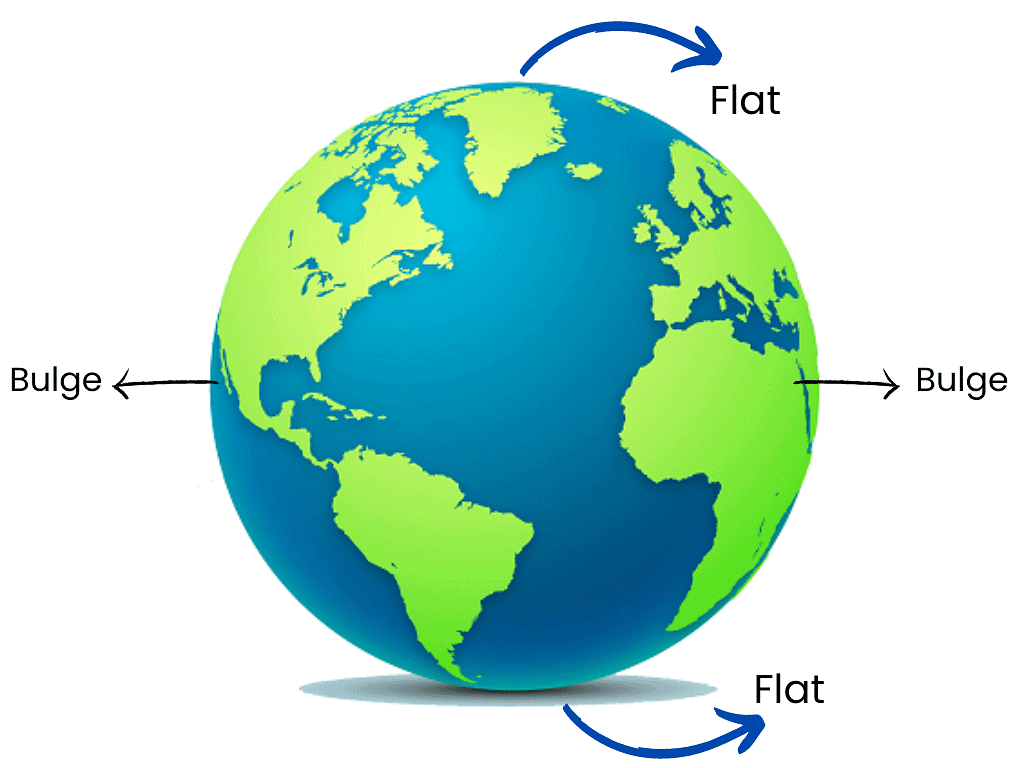
(a) What is the true shape of the Earth?
Ans: The Earth is not a perfect sphere. It is slightly flattened at the North and the South Poles and bulge in the middle.
 Shape of Earth
(b) What is a globe?
Ans: A globe is a spherical figure which is a miniature model of earth. It gives us a three-dimensional view of the whole Earth by showing distances, directions, areas, etc. Globes are available in a variety of sizes and types, like the terrestrial globe and the celestial globe.
 Globe
Globe
(c) What is the latitudinal value of the Tropic of Cancer?
Ans: The Tropic of Cancer lies at 23½º North of the Equator.
 Tropic of Cancer
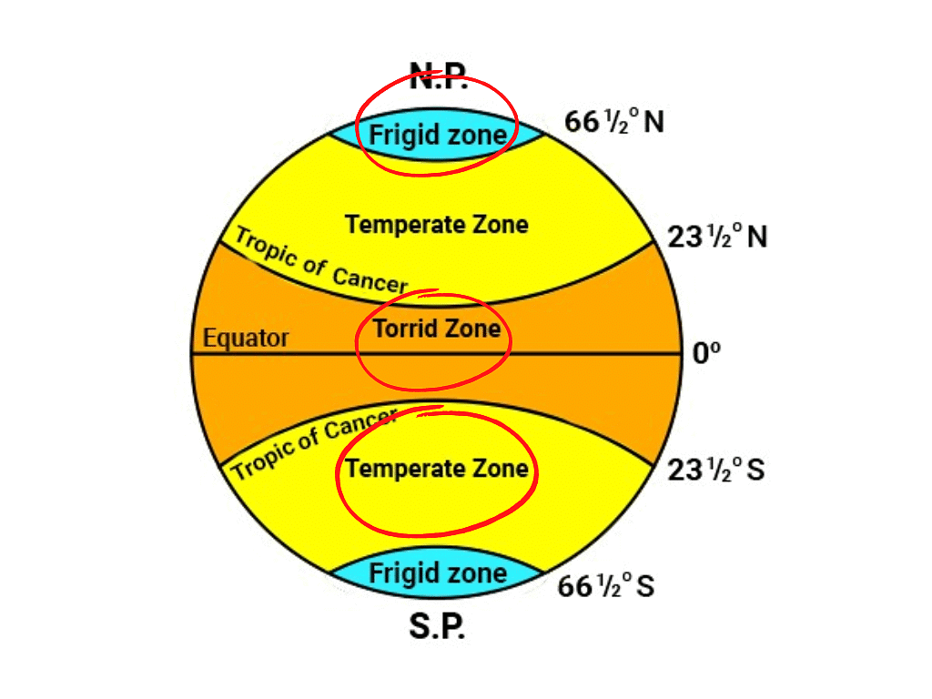
(d) What are the three heat zones of the Earth?
Ans: The three heat zones of the Earth are Torrid Zone, Temperate Zone and Frigid Zone.
 Heat Zones of Earth
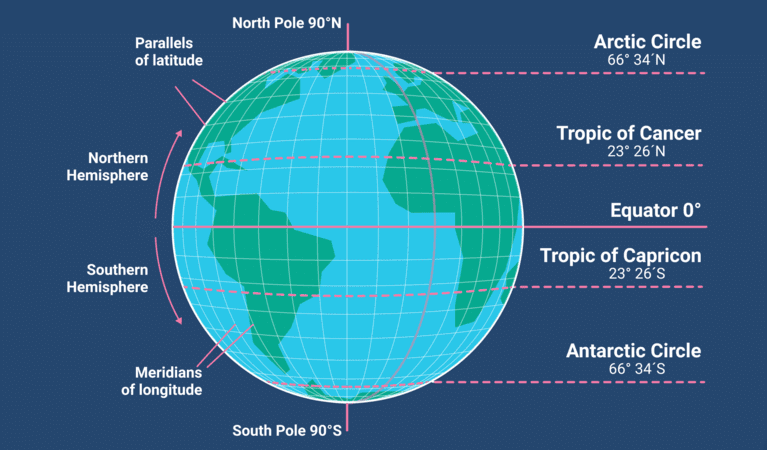
(e) What are parallels of latitude and meridians of longitude?
Ans: All imaginary parallel circles from the equator to the poles are called parallels of latitude. The imaginary set of semi-circle lines that run from the North Pole to the South Pole are called meridians of longitude.
 Latitudes & Longitudes
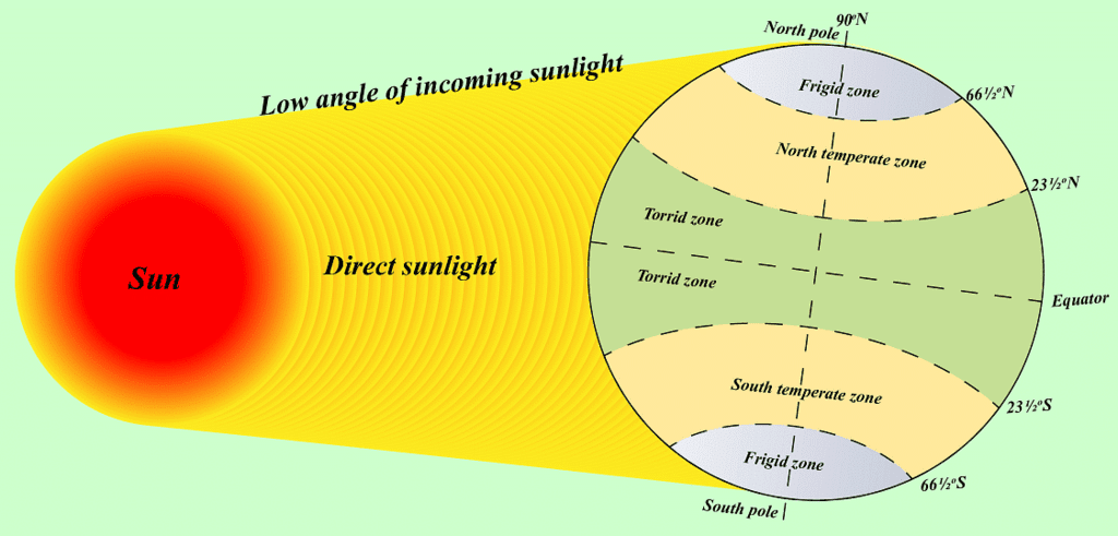
(f) Why does the Torrid zone receive maximum amount of heat?
Ans: The Sun shines perpendicular between the Tropic of Cancer and the Tropic of Capricorn throughout the year. Perpendicular sun rays give more heat than slanting sun rays. Therefore, the Torrid Zone receives the maximum amount of heat.
 Torrid Zone
(g) Why is it 5.30 p.m. in India and 12.00 noon in London?
Ans:
- India and the United Kingdom are situated on different longitudes, which leads to a difference in their local times. The Earth rotates 360 degrees in 24 hours, which means it covers 1 degree of longitude in 4 minutes. Therefore, every degree of longitude corresponds to a 4-minute difference in time.
- London is located at 0° longitude, while the standard meridian of India is 82°30' E longitude. This difference in longitude results in a time difference between the two locations. Since India is to the east of London, time in India is ahead. For every degree eastward, time increases by 4 minutes.
- Calculating for the 82°30' E longitude, the time difference between London and India is:
82.5 degrees x 4 minutes per degree = 330 minutes or 5 hours and 30 minutes. - So, when it is 12 noon in London, it is 5:30 PM in India.
Q2. Choose the correct answers.
(a) The Value of the Prime Meridian Is
(i) 90 °
(ii) 0°
(iii) 60°
Ans: (ii) 0°
(b) The Frigid Zone Lies Near
(i) The Poles
(ii) The Equator
(iii) The Tropic of Cancer
Ans: (i) The Poles
(c) The Total Number of Longitudes are
(i) 360
(ii) 180
(iii) 90
Ans: (ii) 180
(d) The Antarctic Circle is Located in
(i) The Northern hemisphere
(ii) The Southern hemisphere
(iii) The Eastern hemisphere
Ans: (ii) The Southern hemisphere
(e) Grid is a Network of
(i) Parallels of latitudes and Meridians of longitudes
(ii) The Tropic of Cancer and The Tropic of Capricorn
(iii) The North Pole and the South Pole
Ans: (i) Parallels of latitudes and Meridians of longitudes
Q3. Fill in the blanks.
(a) The Tropic of Capricorn is located at _____.
Ans: 23.5 Degrees south of the Equator
(b) The Standard Meridian of India is _____.
Ans: 82½ Degrees E
(c) The 0° Meridian is also known as _____.
Ans: Prime Meridian
(d) The distance between the longitudes decreases towards _____.
Ans: Poles
(e) The Arctic Circle is located in the _____ hemisphere.
Ans: Northern
FAQs on NCERT Solutions: Globe- Latitudes & Longitudes
| 1. Globe पर अक्षांश और देशांतर क्या होते हैं? |  |
| 2. अक्षांश और देशांतर का महत्व क्या है? | |
| 3. अक्षांश रेखाएं किस दिशा में फैली होती हैं? | |
| 4. देशांतर रेखाएं कैसे होती हैं? | |
| 5. Globe पर अक्षांश और देशांतर को कैसे समझा जा सकता है? | |


