NCERT Solutions - India Location

Q1: Choose the right answer from the four alternatives given below.
(i) Which one of the following latitudinal extents is relevant for the extent of India's area?
(a) 8°41'N - 35°7'N
(b) 8°4'N - 37°6'N
(c) 8°4'N - 35°6'N
(d) 6°45'N - 37°6'N
Ans: (b)
Explanation: India's mainland extends roughly from 8°4' N in the south (near Kanyakumari) to 37°6' N in the north (near the Himalayan boundary). Option (b) correctly states this latitudinal span, which explains the north-south climatic and ecological variations across the country.
(ii) Which one of the following countries shares the longest land frontier with India?
(a) Bangladesh
(b) China
(c) Pakistan
(d) Myanmar
Ans: (a)
Explanation: Bangladesh shares the longest land boundary with India because of its extensive common border along India's eastern states. Historical border alignments and long contiguous frontiers make Bangladesh the correct choice.
(iii) Which one of the following countries is larger in area than India?
(a) China
(b) Egypt
(c) France
(d) Iran
Ans: (a)
Explanation: China has a larger land area than India. The other options listed (Egypt, France, Iran) all have smaller total areas than India, so option (a) is correct.
(iv) Which one of the following longitudes is the standard meridian for India?
(a) 69°30'E
(b) 82°30'E
(c) 75°30'E
(d) 90°30'E
Ans: (b)
Explanation: 82°30' E, the meridian passing near Mirzapur (Uttar Pradesh), is chosen as India's standard meridian. It provides Indian Standard Time (IST), which is GMT +5:30, and serves as the single reference meridian for civil time across the country.
Q2: Answer the following questions in about 30 words.
(i) Does India need to have more than one standard time? If yes, why do you think so?
Ans: Yes. India's east-west extent is about 30°, producing nearly two hours difference in local solar time between extremes. Multiple time zones would align daylight hours better with local activities, as in other large countries.
(ii) What are the implications of India having a long coastline?
Ans: A long coastline (including islands) supports international trade and maritime links with West Asia, Africa, Europe and East/Southeast Asia, provides fisheries and port potential, and requires regular coastal surveillance for security and environmental management.
(iii) How is the latitudinal spread of India advantageous to her?
Ans: The latitudinal spread gives varied climates and ecosystems-from tropical south to warm temperate north-resulting in diverse landforms, soils, vegetation and crop patterns that benefit agriculture and biodiversity.
(iv) While the sun rises earlier in the east, say Nagaland and also sets earlier, how do the watches at Kohima and New Delhi show the same time?
Ans: India follows one standard time for the whole country. 82°30' E has been selected as the 'standard meridian' of India. Indian Standard Time is ahead of Greenwich Mean Time by 5 hours and 30 minutes. Therefore, while in Nagaland sun rises earlier and also sets earlier, but the watches at Kohima and New Delhi show the same time.
Project/Activity
Activity based on Appendix I (Teachers may help in the exercises by explaining and getting them done by the students).
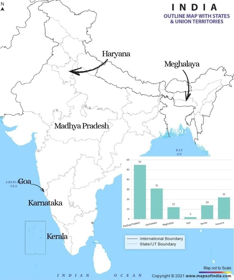
(i) On a graph paper, plot the number of districts in Madhya Pradesh, Karnataka, Meghalaya, Goa, Kerala, and Haryana. Does the number of districts have some relationship with the area of the state?
Ans: Plot the states on the horizontal axis and the number of districts on the vertical axis; draw bars for each state. Observe that larger states tend to have more districts, but population and administrative needs also matter.
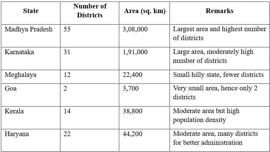
Observation:
- States with larger areas (for example Madhya Pradesh and Karnataka) generally have more districts because more territory typically requires finer administrative division.
- Smaller states (for example Goa and Meghalaya) usually have fewer districts, reflecting their limited area.
- Population density and administrative factors also influence the number of districts - Kerala has a moderate area but more districts due to higher population and administrative considerations.
- Therefore, there is a general relationship between area and number of districts, but it is not exact because other factors are involved.
(ii) Which state amongst Uttar Pradesh, West Bengal, Gujarat, Arunachal Pradesh, Tamil Nadu, Tripura and Rajasthan is the most thickly populated and which one is the least densely populated?
Ans: Among Uttar Pradesh, West Bengal, Gujarat, Arunachal Pradesh, Tamil Nadu, Tripura, and Rajasthan, identify:
- Most thickly populated state: Uttar Pradesh
- Least densely populated state: Arunachal Pradesh
Explanation: Uttar Pradesh has fertile plains and high population density, while Arunachal Pradesh has mountainous terrain and limited habitable land.
(iii) Find out the relationship between the area of the state and the number of districts.
Ans: There is a partial relationship between the area of a state and the number of districts.
- States with larger areas (like Rajasthan and Madhya Pradesh) usually have more districts.
- However, population distribution and administrative needs also affect the number of districts.
Example: Kerala has a small area but relatively more districts due to high population density.
(iv) Identify the states with coastal boundaries.
Ans: The Indian states with coastal boundaries are:
Gujarat, Maharashtra, Goa, Karnataka, Kerala, Tamil Nadu, Andhra Pradesh, Odisha, and West Bengal.
(v) Arrange the states from west to east which have only a land boundary.
Ans: States that do not have a coastline (only land boundaries), arranged from west to east, include:
Rajasthan, Punjab, Haryana, Delhi (NCT), Uttar Pradesh, Bihar, Jharkhand, Chhattisgarh, Madhya Pradesh, Assam, Meghalaya, Nagaland, Manipur, Mizoram, Tripura, and Arunachal Pradesh.
Activity based on Appendix II
(i) List the Union Territories which have a coastal location.
Ans: Union Territories with coastal boundaries are:
- Puducherry
- Andaman and Nicobar Islands
- Lakshadweep
- Dadra and Nagar Haveli and Daman and Diu
(ii) How do you explain the variation in the area and population of NCT Delhi and the Andaman and Nicobar Islands?
Ans: Explanation:
- NCT Delhi has a small area but very high population density due to urbanisation, economic activities, and migration.
- Andaman and Nicobar Islands have a large area but sparse population due to their island geography, forest cover, and limited habitable land.
(iii) On a graph paper, draw a bar diagram to show the area and population of all the Union Territories.
Ans:
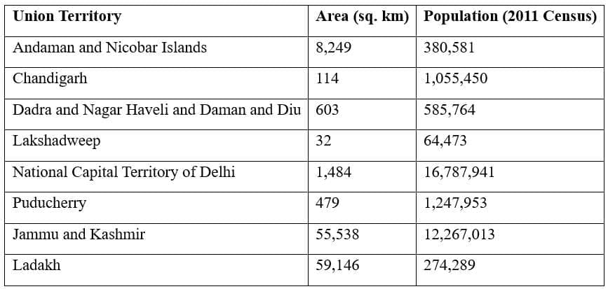
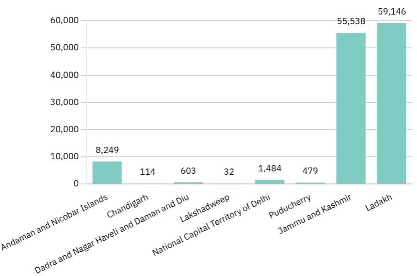 Area of UTs
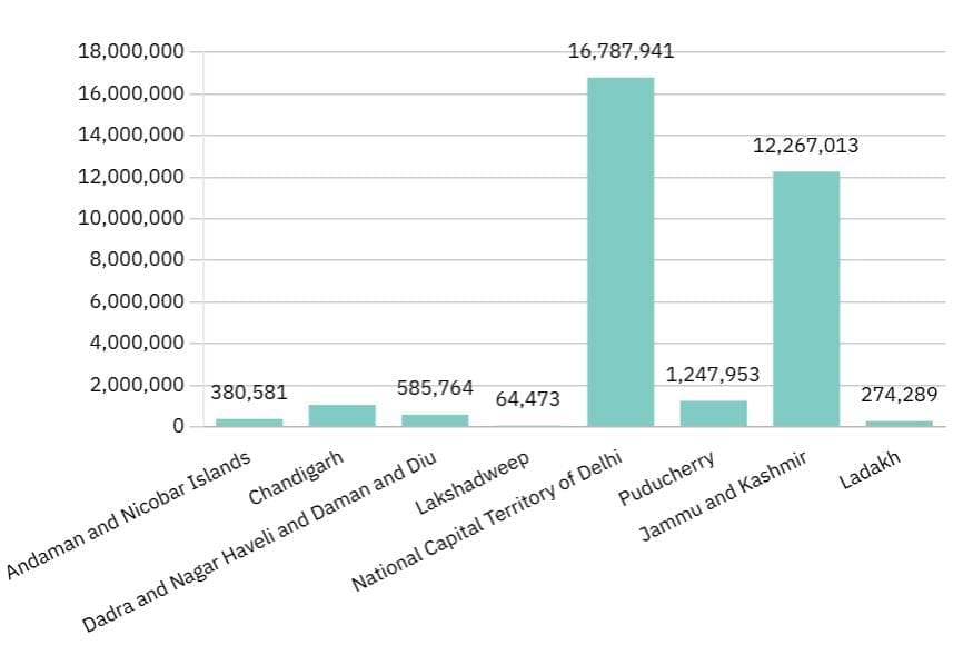 Population of UTs as per Census 2011
FAQs on NCERT Solutions - India Location
| 1. Where is India located geographically? |  |
| 2. What is the significance of India's location? | |
| 3. How does India's location impact its climate? | |
| 4. How does India's location influence its cultural diversity? | |
| 5. How does India's location affect its relationship with neighboring countries? | |


