Q1: Choose the right answer from the four alternatives given below.
(i) Which one of the water bodies separates the Andaman from the Nicobar?
(a) 11° Channel
(b) Gulf of Mannar
(c) 10° Channel
(d) Andaman Sea
Ans: (c) - The 10° Channel separates the Andaman Islands (to the north) from the Nicobar Islands (to the south).
(ii) On which of the following hill ranges is the 'Dodabeta' peak situated?
(a) Nilgiri hills
(b) Anaimalai hills
(c) Cardamom hills
(d) Nallamala hills
Ans: (a) - Dodabetta (often spelt Dodabeta in some sources) is the highest peak of the Nilgiri Hills in Tamil Nadu.
Q2: Answer the following questions in about 30 words.
(i) If a person is to travel to Lakshadweep, from which coastal plain does he prefer and why?
Ans: He would prefer the western coastal plain because Lakshadweep lies in the Arabian Sea off the Malabar (Kerala) coast. The western coast provides the shortest sea route to the islands.
(ii) Where in India will you find a cold desert? Name some important ranges of this region.
Ans: Cold desert occurs in the Trans-Himalayan region (Ladakh) in the rain shadow of the Greater Himalayas. Important ranges include the Ladakh Range, Zanskar Range and the Karakoram.
(iii) Why is the western coastal plain is devoid of any delta?
Ans: The western coastal plain is narrow, and the Western Ghats lie close to the coast. Rivers are short, steep and swift, carrying sediments to the sea quickly, so they do not form large deltas (they form estuaries instead).
Q3: Answer the following questions in not more than 125 words.
(i) Make a comparison of the island groups of the Arabian Sea and the Bay of Bengal.
Ans: Island group of the Arabian Sea (Lakshadweep):
- Consists of about 36 islands, of which around 10 are inhabited.
- Located between approximately 8°-12°N latitudes and 71°-74°E longitudes off the Kerala coast.
- Formed mainly of coral atolls and reefs (coral origin).
- Minicoy (Maliku) is the largest island (area about 4.6 km²) and the islands lie a few hundred kilometres offshore.
- Consists of several hundred islands (commonly cited total ~572 islands for the group).
- Located between about 6°-14°N latitudes and 92°-94°E longitudes.
- Divided into the Andaman group (north) and the Nicobar group (south).
- The two groups are separated by the 10° Channel.
- Many islands are parts of an elevated submarine mountain chain; some are volcanic in origin.
(ii) What are the important geomorphological features found in the river valley plains?
Ans: River valley plains show a sequence of distinct belts and landforms formed by river deposition and reworking:
- Bhabar: A narrow, coarse alluvium belt at the foot of the Shiwaliks, where streams disappear into porous deposits (about 8-16 km wide).
- Tarai: South of Bhabar; a marshy, swampy belt where underground water reappears and channels spread out (about 10-20 km wide).
- Bhangar: Upland region of older alluvium forming terraces above the floodplain (composed of compact older deposits).
- Khadar (Khadar): Low-lying floodplain of newer alluvium; renewed by regular floods and highly fertile.
- Delta: Depositional landform at the river mouth where sediments build out into the sea (for example, the Sundarbans at the Ganga-Brahmaputra delta).
(iii) If you move from Badrinath to the Sunderbans delta along the course of the river Ganga, what major geomorphological features will you come across?
Ans: Travelling downstream from Badrinath to the Sundarbans, you cross these major geomorphological zones:
- Himalayan source region: Glacial valleys, steep V-shaped valleys, gorges, rapids and waterfalls in the Higher Himalaya.
- Siwalik and foothill zone: Narrow valleys and the transition to the piedmont belts (Bhabar and Tarai).
- Indo-Gangetic Plain: Broad alluvial plains with depositional features - meanders, oxbow lakes, sand bars, braided channels, floodplains (Khadar) and terraces (Bhangar).
- Deltaic region: The low, swampy Sunderbans delta with distributary channels, tidal flats and mangrove forests where the river meets the Bay of Bengal.
Project/Activity
(i) Make a list of major Himalayan peaks from the west to the east with the help of an atlas.
Ans: 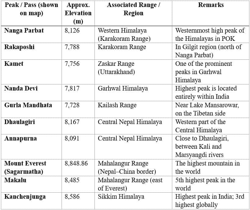
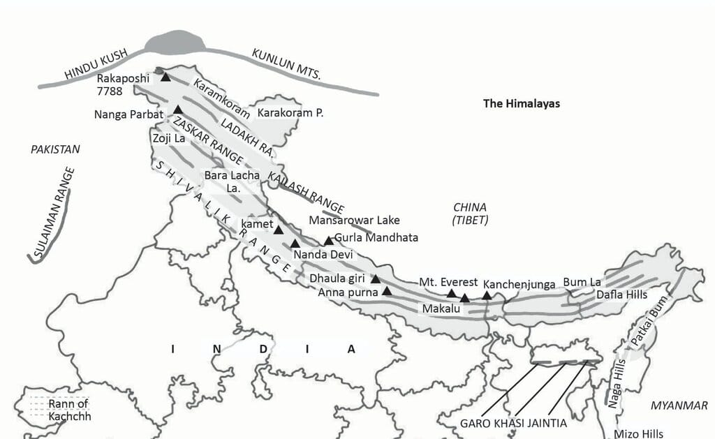
- Peaks are aligned roughly west to east, beginning from Nanga Parbat (Pakistan region) and ending at Namcha Barwa (Arunachal Pradesh).
- The Himalayas curve convexly southward.
- Major ranges include Karakoram, Ladakh, Zaskar, Greater Himalaya, Kailash Range, and Purvanchal Hills.
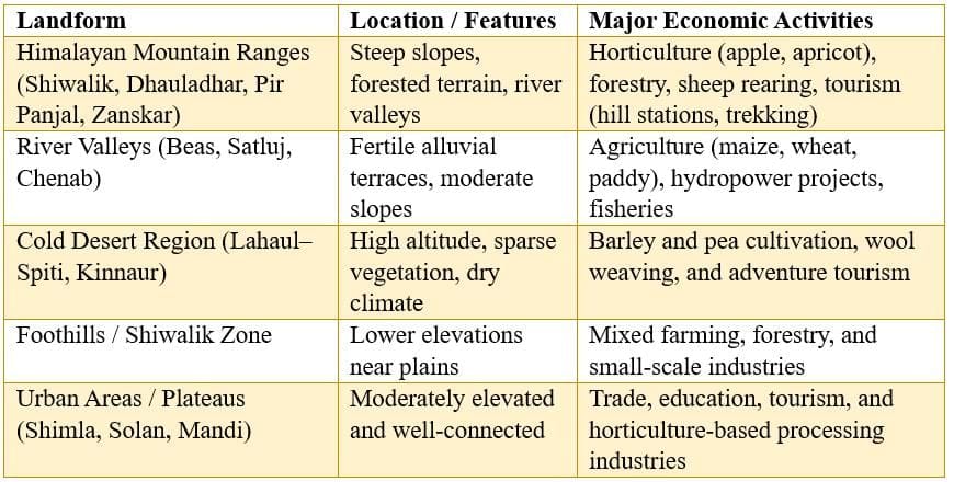
(ii) Identify the major landforms of your state and analyse the major economic activity practised by the people in each landform.
Ans: (Example provided for Himachal Pradesh - replace with your state if needed.)