NCERT Solutions - Drainage System

Q1: Choose the right answer from the four alternatives given below.
(i) Which one of the following rivers was known as the 'Sorrow of Bengal'?
(a) The Gandak
(b) The Son
(c) The Kosi
(d) The Damodar
Ans: (d)
Explanation: The Damodar River caused frequent and severe floods in the plains of West Bengal and Bihar in the past, earning it the local name "Sorrow of Bengal". Its heavy seasonal discharge and flooding problems were well known before flood-control measures were introduced.
(ii) Which one of the following rivers has the largest river basin in India?
(a) The Indus
(b) The Brahmaputra
(c) The Ganga
(d) The Krishna
Ans: (c)
Explanation: The Ganga River system drains the largest area in India. Its basin includes many major tributaries and extends over a vast portion of northern India, making it the largest river basin in the country.
(iii) Which one of the following rivers is not included in 'Panchnad'?
(a) The Ravi
(b) The Chenab
(c) The Indus
(d) The Jhelum
Ans: (c)
Explanation: 'Panchnad' refers to the five rivers-Jhelum, Chenab, Ravi, Beas and Sutlej-that join in the Punjab region. The Indus is a separate major river and is not counted among these five.
(iv) Which one of the following rivers flows in a rift valley?
(a) The Son
(b) The Narmada
(c) The Yamuna
(d) The Luni
Ans: (b)
Explanation: The Narmada flows westwards in a rift valley between the Vindhya and Satpura ranges. Its straight course and the presence of linear valleys are characteristic of rivers flowing in rift valleys.
(v) Which one of the following is the place of confluence of the Alaknanda and the Bhagirathi?
(a) Vishnu Prayag
(b) Rudra Prayag
(c) Karan Prayag
(d) Deva Prayag
Ans: (d)
Explanation: The Bhagirathi and Alaknanda join at Deva Prayag; from that confluence the river is known as the Ganga. The other prayags are confluences of different tributaries upstream.
Q2: State the differences between the following.
(i) River Basin and Watershed
Ans:
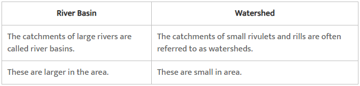
Ans: A clear comparison is:
- River Basin: The total area drained by a river and its tributaries; it is bounded by a drainage divide and channels all runoff into a particular river system.
- Watershed: A smaller area or ridge that separates two adjacent drainage basins; often used to mean the local drainage area that feeds a particular stream or river segment.
- Key difference: A river basin is the entire drainage area of a river network, while a watershed is usually a smaller catchment or the boundary (ridge) that divides two basins.
(ii) Dendritic and Trellis drainage pattern
Ans:
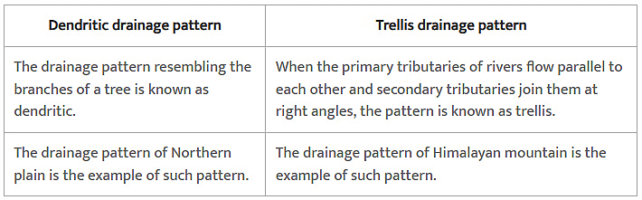
Ans:
- Dendritic pattern: Resembles the branches of a tree; occurs on relatively uniform material with gentle slopes where tributaries join at acute angles. It indicates homogenous substrate and minimal structural control.
- Trellis pattern: Resembles a garden trellis; occurs in areas of alternating resistant and weak rock strata, typically in folded terrains. Main streams flow parallel in valleys and tributaries enter at near right angles.
- Key difference: Dendritic patterns reflect uniform geology and slope, while trellis patterns reflect structural control by alternating rock resistance and folding.
(iii) Radial and Centripetal drainage pattern
Ans:
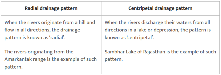
Ans:
- Radial pattern: Streams radiate outward from a central high point, such as a volcano or conical hill, flowing away in all directions from the summit.
- Centripetal pattern: Streams converge toward a central low point, such as a basin, lake or depression, draining inward from the surrounding higher ground.
- Key difference: Radial drainage disperses water away from a central high, whereas centripetal drainage collects water toward a central low.
(iv) Delta and Estuary
Ans:
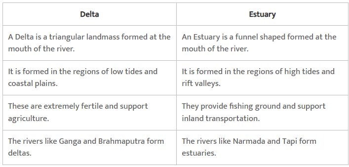
Ans:
- Delta: A depositional landform formed at a river mouth where the river deposits sediments and builds out into the sea or a lake; typically triangular or fan-shaped and composed of distributary channels and alluvial deposits.
- Estuary: A drowned river valley where the sea has flooded the lower course of a river; characterised by tidal influence, mixing of fresh and salt water, and typically deep, funnel-shaped channels.
- Key difference: A delta is formed mainly by deposition of sediments by the river, while an estuary is a tidal inlet formed by submergence of the lower river valley and dominated by tidal processes.
Q3: Answer the following questions in about 30 words.
(i) What are the socio-economic advantages of inter-linking of rivers in India?
Ans: The socio-economic advantages of inter-linking of rivers in India are:
- Excess water from flood-prone regions can be transferred to drought-prone areas, helping to reduce both floods and water scarcity.
- Improved inland waterway transport would lower transportation costs and make movement of goods easier across regions.
- Expanded and more reliable irrigation would increase agricultural productivity and support rural livelihoods.
- Additional opportunities such as hydroelectric power generation and fisheries development would support local economies.
(ii) Write three characteristics of the Peninsular river.
Ans: Three characteristics of the Peninsular rivers are:
- They originate on the Peninsular plateau and in the central highlands rather than in young mountain ranges.
- They are largely seasonal and depend predominantly on monsoon rainfall for their flow.
- They have well-defined, stable channels and shorter courses compared with Himalayan rivers, and their valleys are generally older and less steep.
Q4: Answer the following questions in not more than 125 words.
(i) What are the important characteristic features of north Indian rivers? How are these different from Peninsular rivers?
Ans:
- Key characteristics of north Indian (Himalayan) rivers:
- They originate in the Himalayas, often from glaciers and high-altitude snowfields.
- They are largely perennial, receiving water year-round from glacial melt and monsoon rains.
- In their upper reaches they form deep gorges and V-shaped valleys and show strong vertical erosion.
- They have long courses and large drainage basins, with numerous tributaries contributing to high discharge.
- They are youthful rivers in terms of valley form, with active downcutting and dynamic channel behaviour.
Differences from Peninsular rivers:
- North Indian rivers have much larger basins; Peninsular rivers drain smaller, more restricted areas.
- Himalayan rivers are perennial because of glacial and snow melt; Peninsular rivers are largely seasonal, driven mainly by monsoon rainfall.
- Himalayan rivers often show antecedent or consequent courses and create extensive alluvial plains; Peninsular rivers commonly display patterns controlled by local structure (trellis, radial) and have more mature, graded profiles.
- Peninsular rivers are older and nearer to base level with well-developed valleys, whereas Himalayan rivers are geologically younger and actively eroding.
(ii) Suppose you are travelling from Haridwar to Siliguri along the foothills of the Himalayas. Name the important rivers you will come across. Describe the characteristics of any one of them.
Ans: If we are travelling from Haridwar to Siliguri along the foothills of the Himalayas, we will come across rivers such as the Gomti, Ramganga, Rapti, Gandak, Kosi, Kamla, Saryu, Ghaghra (Gogra), Sharda (Mahakali in parts), Mahananda and the Ganga.
The characteristics of Gandak:
- It rises in the Nepal Himalaya between the Dhaulagiri range and the Everest region and drains a central part of Nepal as well as parts of northern India.
- It is formed by several tributaries; prominent headstreams include the Kali Gandaki (Kali Gandak) and other mountain streams.
- It enters the Ganga plain in the Champaran district of Bihar and joins the Ganga near Patna (Sonpur region).
- Its length in the combined river system is about 630 km and it carries significant sediment load from the Himalayas into the Ganga plain.
FAQs on NCERT Solutions - Drainage System
| 1. What is the importance of a drainage system in urban areas? |  |
| 2. How does a drainage system help in preventing waterborne diseases? | |
| 3. What are the different components of a typical drainage system? | |
| 4. How can clogging in a drainage system be prevented? | |
| 5. What are the environmental benefits of a well-designed drainage system? | |


