Physical & Political Indian Geography - Free MCQ Practice Test with solutions,
MCQ Practice Test & Solutions: Test: Physical & Political Indian Geography (5 Questions)
You can prepare effectively for UPSC Additional Study Material for UPSC with this dedicated MCQ Practice Test (available with solutions) on the important topic of "Test: Physical & Political Indian Geography". These 5 questions have been designed by the experts with the latest curriculum of UPSC 2026, to help you master the concept.
Test Highlights:
- - Format: Multiple Choice Questions (MCQ)
- - Duration: 10 minutes
- - Number of Questions: 5
Sign up on EduRev for free to attempt this test and track your preparation progress.

Consider the following statements:
1. India is the 6th largest country in the world.
2. It extends between 8°4' and 37° 6' north latitudes and 68°7' and 97°25' east longitudes.
3. India lies in the northern hemisphere.
Which of the statements given above is/are correct?
1. India is the 6th largest country in the world.
2. It extends between 8°4' and 37° 6' north latitudes and 68°7' and 97°25' east longitudes.
3. India lies in the northern hemisphere.
Detailed Solution: Question 1
Through which of the following state, the tropic of cancer does not pass?
Detailed Solution: Question 2

Consider the following statements:
1. India takes its standard time from the meridian of 82°30' E.
2. It is five and a half hours ahead of Greenwich Mean Time.
Which of the statements given above is/are correct?
1. India takes its standard time from the meridian of 82°30' E.
2. It is five and a half hours ahead of Greenwich Mean Time.
Detailed Solution: Question 3
Consider the following pairs:
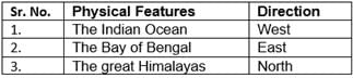
Which of the pairs given above is are correct?
Which of the pairs given above is are correct?
Detailed Solution: Question 4
With which of the following country India shares the longest border?
Detailed Solution: Question 5
18 videos|561 docs|160 tests |