Class 8 Exam > Class 8 Tests > Test: Indian Geography- 2 - Class 8 MCQ
Test: Indian Geography- 2 - Class 8 MCQ
Test Description
10 Questions MCQ Test - Test: Indian Geography- 2
Test: Indian Geography- 2 for Class 8 2024 is part of Class 8 preparation. The Test: Indian Geography- 2 questions and answers have been prepared
according to the Class 8 exam syllabus.The Test: Indian Geography- 2 MCQs are made for Class 8 2024 Exam.
Find important definitions, questions, notes, meanings, examples, exercises, MCQs and online tests for Test: Indian Geography- 2 below.
Solutions of Test: Indian Geography- 2 questions in English are available as part of our course for Class 8 & Test: Indian Geography- 2 solutions in
Hindi for Class 8 course.
Download more important topics, notes, lectures and mock test series for Class 8 Exam by signing up for free. Attempt Test: Indian Geography- 2 | 10 questions in 20 minutes | Mock test for Class 8 preparation | Free important questions MCQ to study for Class 8 Exam | Download free PDF with solutions
Detailed Solution for Test: Indian Geography- 2 - Question 1
Detailed Solution for Test: Indian Geography- 2 - Question 2
| 1 Crore+ students have signed up on EduRev. Have you? Download the App |
Test: Indian Geography- 2 - Question 3
The Indian subcontinent was originally part of a huge land mass called?
Detailed Solution for Test: Indian Geography- 2 - Question 3
Test: Indian Geography- 2 - Question 4
Consider the following statements:
- The Himalayan ranges were formed when the Indian Plate was driven northwards and pushed beneath the Eurasian Plate.
- The Himalayas have reached their old age in the geological history of the earth.
Which of the following statements is/are correct?
Detailed Solution for Test: Indian Geography- 2 - Question 4
Test: Indian Geography- 2 - Question 5
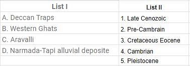
Match List I with List II and select the correct answer by using the code given.

Detailed Solution for Test: Indian Geography- 2 - Question 5
Test: Indian Geography- 2 - Question 6
The Equator does NOT pass through which of the following countries?
Detailed Solution for Test: Indian Geography- 2 - Question 6
Detailed Solution for Test: Indian Geography- 2 - Question 7
Test: Indian Geography- 2 - Question 8
Find out the correct sequence of the Himalayan peaks in descending order of height above sea level.
Detailed Solution for Test: Indian Geography- 2 - Question 8
Detailed Solution for Test: Indian Geography- 2 - Question 9
Test: Indian Geography- 2 - Question 10
Which of the following bodies has grouped India into four zones as per their propensities of seismicity?
Detailed Solution for Test: Indian Geography- 2 - Question 10
Information about Test: Indian Geography- 2 Page
In this test you can find the Exam questions for Test: Indian Geography- 2 solved & explained in the simplest way possible.
Besides giving Questions and answers for Test: Indian Geography- 2, EduRev gives you an ample number of Online tests for practice
Download as PDF


