SSC CGL Exam  >  SSC CGL Tests  >  Prelims Map Based Questions - 8 - SSC CGL MCQ

Prelims Map Based Questions - 8 - SSC CGL MCQ


Test Description

20 Questions MCQ Test - Prelims Map Based Questions - 8

Prelims Map Based Questions - 8 for SSC CGL 2024 is part of SSC CGL preparation. The Prelims Map Based Questions - 8 questions and answers have been prepared according to the SSC CGL exam syllabus.The Prelims Map Based Questions - 8 MCQs are made for SSC CGL 2024 Exam. Find important definitions, questions, notes, meanings, examples, exercises, MCQs and online tests for Prelims Map Based Questions - 8 below.
Solutions of Prelims Map Based Questions - 8 questions in English are available as part of our course for SSC CGL & Prelims Map Based Questions - 8 solutions in Hindi for SSC CGL course. Download more important topics, notes, lectures and mock test series for SSC CGL Exam by signing up for free. Attempt Prelims Map Based Questions - 8 | 20 questions in 25 minutes | Mock test for SSC CGL preparation | Free important questions MCQ to study for SSC CGL Exam | Download free PDF with solutions
Prelims Map Based Questions - 8 - Question 1

The Formosa Strait also known as Taiwan Strait connects which of the following seas?

Detailed Solution for Prelims Map Based Questions - 8 - Question 1

Option (a) is the correct answer: Formosa Strait connects East China Sea with South China Sea.

Prelims Map Based Questions - 8 - Question 2

Travelling from west to east, arrange the following capital cities in sequential order:

  1. Riyadh
  2. Ankara
  3. Damascus
  4. Tehran
  5. Kuwait City

Select the correct option from the codes given below:

Detailed Solution for Prelims Map Based Questions - 8 - Question 2

Option (b) is correct: Ankara (Turkey)-Damascus (Syria)-Riyad (Saudi Arabia)-
Kuwait City (Kuwait)-Tehran (Iran).

1 Crore+ students have signed up on EduRev. Have you? Download the App
Prelims Map Based Questions - 8 - Question 3

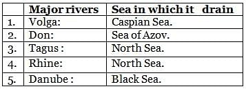
Consider the following pairs:

Which of the pairs given above are correctly matched?
Detailed Solution for Prelims Map Based Questions - 8 - Question 3

Statement 3 is incorrect. River Tagus drains into the Atlantic ocean.

Prelims Map Based Questions - 8 - Question 4

What is the correct sequence of occurrence of the following water bodies from south to north?

  1. Port Said
  2. Lake Timsah
  3. Port Tewfik
  4. Great Bitter lake

Select the correct answer using the code given below.

Detailed Solution for Prelims Map Based Questions - 8 - Question 4

Option d is the correct: sequence starting from south to north.
Suez Canal

  • The Suez Canal situated in Egypt is an artifi cial sea-level waterway connecting the Mediterranean Sea to the Red Sea through the Isthmus of Suez and dividing Africa and Asia.
  • Its work started in 1859 Suez Canal Company and lasted till 1869. The canal offi  cially opened on 17 November 1869.
  • The northern terminus of  Suez Canal is Port Said and the southern terminus is  Port Tewfi k at the city of Suez.
Prelims Map Based Questions - 8 - Question 5

Consider the following pairs:

Which of the pairs given above are correctly matched?

Detailed Solution for Prelims Map Based Questions - 8 - Question 5

Statement 3 is incorrect. The Western Desert of Egypt is an area of the Sahara that lies west of the river Nile, up to the border of Libya and south of the Mediterranean Sea till the border of Sudan.

Prelims Map Based Questions - 8 - Question 6

Taiwan Strait connects South China Sea with:

Detailed Solution for Prelims Map Based Questions - 8 - Question 6

Taiwan Strait

  • Recently, USA’s Arleigh Burke-class guidedmissile destroyer USS Milius passed through the Taiwan Strait.  It is a 110-mile-wide channel that separates mainland China from the island of Taiwan.
  • It is also known as the Formosa Strait or the Tai-hai (the Tai Sea).
  • The strait borders the southeastern part of China and runs along the eastern part of China’s Fujian Province.
  • Taiwan Strait connects South China Sea with the East China Sea while the Luzon Strait connects South China Sea with the Philippine Sea.
  • South China Sea is a marginal sea, an arm of western Pacifi c Ocean in Southeast Asia.
  • The People’s Republic of China, the Republic of China (Taiwan), the Philippines, Malaysia, Brunei, Indonesia, Singapore and Vietnam border the South China Sea.
Prelims Map Based Questions - 8 - Question 7

Which of the following countries’ land border surrounds Black Sea?

  1. Turkey
  2. Russia
  3. Armenia
  4. Georgia

Select the correct code from the available options:

Prelims Map Based Questions - 8 - Question 8

Grand Ethiopian Renaissance Dam is situated on which of the following river?

Detailed Solution for Prelims Map Based Questions - 8 - Question 8

The Grand Ethiopian Renaissance Dam

  • Formerly known as the Millennium Dam, it is a gravity dam on the Blue Nile River in Ethiopia under construction since 2011.
  • The dam is in the Benishangul-Gumuz Region of Ethiopia, about 45 km (28 mi) east of the border with Sudan.
Prelims Map Based Questions - 8 - Question 9

Which of the following countries are not landlocked?

  1. Mali
  2. Nigeria
  3. Guinea
  4. Ghana

Select the correct code:

Detailed Solution for Prelims Map Based Questions - 8 - Question 9

Option (c) is correct: Mali is a landlocked country.

Prelims Map Based Questions - 8 - Question 10

Arrange the following mountain passes in north-south direction?

  1. Baralacha La
  2. Chang La
  3. Aghil
  4. Banihal

Select the correct answer using the code given below:

Detailed Solution for Prelims Map Based Questions - 8 - Question 10

The correct order is Aghil- Chang La- Baralacha La- Banihal.

Prelims Map Based Questions - 8 - Question 11

Which of the following countries is the only country in the Arab world that is entirely in the Southern Hemisphere?

Prelims Map Based Questions - 8 - Question 12

The land border of Haiti is closest to which of the following countries?

Detailed Solution for Prelims Map Based Questions - 8 - Question 12

Haiti

  • Haiti is a country located on the island of Hispaniola in the Greater Antilles archipelago of the Caribbean Sea, to the east of Cuba and Jamaica and south of The Bahamas and the Turks and Caicos Islands.
  • It occupies the western three-eighths of the island which it shares with the Dominican Republic.
  • Cuba is the nearest located country to Haiti after Dominican Republic.
  • Haiti became the fi rst free black republic in the world and the fi rst independent state in the Caribbean in 1804.
  • Its capital is Port-au-Prince.
Prelims Map Based Questions - 8 - Question 13

Which of the following countries share land border with Afghanistan?

  1. Uzbekistan
  2. Turkmenistan
  3. Tajikistan

Select the correct answer using the code given below:

Prelims Map Based Questions - 8 - Question 14

Luzon Strait connects South China Sea with:

Detailed Solution for Prelims Map Based Questions - 8 - Question 14

South China Sea

  • South China Sea is a marginal sea, an arm of western Pacific Ocean in Southeast Asia.
  • The People’s Republic of China, the Republic of China (Taiwan), the Philippines, Malaysia, Brunei, Indonesia, Singapore and Vietnam border the South China Sea.
  • Taiwan Strait connects South China Sea with the East China Sea while the Luzon Strait connects it with the Philippine Sea.  It contains numerous shoals, reefs, atolls and islands like the Paracel Islands, the Spratly Islands, the Scarborough Shoal, the Pratas Islands and the Macclesfi eld Bank.
  • The sea carries tremendous strategic importance; one-third of the world’s shipping passes through it, carrying over $3 trillion in trade each year and an estimated 11 billion barrels of untapped oil and 190 trillion cubic feet of natural gas.
  • There are a few hundred small islands in the SCS, a part of the Pacific Ocean. Some of the main ones are Spratly Islands, Paracel Islands and Scarborough Shoal — the bone of contention between China and the Philippines. China claims most of these islands as its own. Vietnam, Malaysia, Brunei, the Philippines and Taiwan have rival claims.
Prelims Map Based Questions - 8 - Question 15

Arrange the following shrines in east to west direction?

  1. Yamunotri
  2. Badrinath
  3. Gangotri
  4. Kedarnath

Select the correct answer using the code given below:

Detailed Solution for Prelims Map Based Questions - 8 - Question 15

Option (c) is correct: Badrinath- Kedarnath- Gangotri- Yamunotri

Prelims Map Based Questions - 8 - Question 16

Red Sea is  bordered  by which of the following African countries?

  1. Egypt
  2. Sudan
  3. Yemen
  4. Ethiopia
  5. Eritrea

Which of the pairs given above are correctly matched?

Detailed Solution for Prelims Map Based Questions - 8 - Question 16

Statement 3 and 4  are  incorrect. From African side four countries touch Red sea Egypt, Sudan, Eritrea and Djibouti

Prelims Map Based Questions - 8 - Question 17

Which of the following countries  are the part of Alps Mountain ranges.

  1. Austria
  2. France
  3. Germany
  4. Monaco
  5. Spain

Select the correct answer using the code given below.

Prelims Map Based Questions - 8 - Question 18

Lake Ontario is connected to the Atlantic Ocean by which river?

Detailed Solution for Prelims Map Based Questions - 8 - Question 18

Option (b) is correct: Lake Ontario is connected to the Atlantic Ocean by St. Lawrence River.

Prelims Map Based Questions - 8 - Question 19

The Pamir Knot is the junction of fi ve mountain ranges. Which of the following is/are not one of them?

  1. KunlunMountains
  2. Zagros Mountains
  3. KarakoramMountains
  4. KirtharMountains
  5. Hindu KushMountains

Select the correct option from the codes given below:

Detailed Solution for Prelims Map Based Questions - 8 - Question 19

Option (d) is the correct answer:The Pamir Knot is the junction of fi ve mountain ranges they are the Tien Shan, the Hindu Kush, the Kunlun, the Karakoram, and the Himalayan ranges.

Prelims Map Based Questions - 8 - Question 20

Consider the following pairs:

Which of the above pairs is/are correctly matched?

Detailed Solution for Prelims Map Based Questions - 8 - Question 20

All pairs are incorrectly matched

  • NH 4: This road running from the capital city of Port Blair to Diglipur connecting all major towns of Ferrargunj, Baratang, Kadamtala, Rangat, Billy Ground, Nimbudera, Mayabunder and Diglipur.
  • NH 6: The highway passes through the Indian states of Meghalaya, Assam, and Mizoram.
  • NH 15: This highway starts from Baihata in Assam and terminates at Wakro in Arunachal Pradesh.
Information about Prelims Map Based Questions - 8 Page
In this test you can find the Exam questions for Prelims Map Based Questions - 8 solved & explained in the simplest way possible. Besides giving Questions and answers for Prelims Map Based Questions - 8, EduRev gives you an ample number of Online tests for practice

Top Courses for SSC CGL

Download as PDF

Top Courses for SSC CGL