Humanities/Arts Exam  >  Humanities/Arts Tests  >  Geography: CUET Mock Test - 1 - Humanities/Arts MCQ

Geography: CUET Mock Test - 1 - Humanities/Arts MCQ


Test Description

30 Questions MCQ Test - Geography: CUET Mock Test - 1

Geography: CUET Mock Test - 1 for Humanities/Arts 2024 is part of Humanities/Arts preparation. The Geography: CUET Mock Test - 1 questions and answers have been prepared according to the Humanities/Arts exam syllabus.The Geography: CUET Mock Test - 1 MCQs are made for Humanities/Arts 2024 Exam. Find important definitions, questions, notes, meanings, examples, exercises, MCQs and online tests for Geography: CUET Mock Test - 1 below.
Solutions of Geography: CUET Mock Test - 1 questions in English are available as part of our course for Humanities/Arts & Geography: CUET Mock Test - 1 solutions in Hindi for Humanities/Arts course. Download more important topics, notes, lectures and mock test series for Humanities/Arts Exam by signing up for free. Attempt Geography: CUET Mock Test - 1 | 40 questions in 45 minutes | Mock test for Humanities/Arts preparation | Free important questions MCQ to study for Humanities/Arts Exam | Download free PDF with solutions
Geography: CUET Mock Test - 1 - Question 1

Directions: Read the following passage carefully:

The pressure on land resources is increasing with more demand for food production. This has forced farmers to develop land for agriculture production and adopt intensive and unsustainable land-use techniques that can cause high levels of soil erosion. Increasing pressures of urbanisation and industrialisation and anthropogenic activities such as building of roads, dams, construction activities are also increasing the rate of erosion of the soil in India. The different kinds and increasing extent of erosion contribute to rapid conversion of cultivable lands into wastelands. For example, recent evidence shows that about 20% of the total geographical area of the country has been converted into wastelands.
Since the causes of soil erosion differ from one area to the other, different methods such as contour tillage, contour bunding, construction of check dams, terrace farming etc are used to prevent erosion and improve soil quality.
Source: Indiawaterportal.org, Aarti Kelkar Khambete, 2021.

Q. Which of the following is NOT an example of human intervention causing soil erosion?

Detailed Solution for Geography: CUET Mock Test - 1 - Question 1

In the last paragraph, various techniques which are being used to control soil erosion have been mentioned. For example: contour tillage, contour bunding, terrace farming, etc. Thus, terrace farming is a human intervention that controls soil erosion instead of aggravating it. All other options are examples of human interventions which lead to soil erosion, transforming the cultivable lands into wastelands.

Geography: CUET Mock Test - 1 - Question 2

Directions: Read the following passage carefully:

The pressure on land resources is increasing with more demand for food production. This has forced farmers to develop land for agriculture production and adopt intensive and unsustainable land-use techniques that can cause high levels of soil erosion. Increasing pressures of urbanisation and industrialisation and anthropogenic activities such as building of roads, dams, construction activities are also increasing the rate of erosion of the soil in India. The different kinds and increasing extent of erosion contribute to rapid conversion of cultivable lands into wastelands. For example, recent evidence shows that about 20% of the total geographical area of the country has been converted into wastelands.
Since the causes of soil erosion differ from one area to the other, different methods such as contour tillage, contour bunding, construction of check dams, terrace farming etc are used to prevent erosion and improve soil quality.
Source: Indiawaterportal.org, Aarti Kelkar Khambete, 2021.

Q. There are two statements given below, marked as Assertion (A) and Reason (R). Read the statements and choose the correct option.

Assertion (A): Soil erosion is increasing in India.
Reason (R): The causes of soil erosion differ from one place to another.

Detailed Solution for Geography: CUET Mock Test - 1 - Question 2

Both the assertion and the reason are correct. The assertion is correct according to the statement 'Increasing pressures of urbanisation and . . . of the soil in India.' The reason is correct according to the statement 'Since the causes of . . . improve soil quality.' However, the reason does not explain the assertion, and they act as independent statements.

1 Crore+ students have signed up on EduRev. Have you? Download the App
Geography: CUET Mock Test - 1 - Question 3

Directions: Read the following passage carefully:

The pressure on land resources is increasing with more demand for food production. This has forced farmers to develop land for agriculture production and adopt intensive and unsustainable land-use techniques that can cause high levels of soil erosion. Increasing pressures of urbanisation and industrialisation and anthropogenic activities such as building of roads, dams, construction activities are also increasing the rate of erosion of the soil in India. The different kinds and increasing extent of erosion contribute to rapid conversion of cultivable lands into wastelands. For example, recent evidence shows that about 20% of the total geographical area of the country has been converted into wastelands.
Since the causes of soil erosion differ from one area to the other, different methods such as contour tillage, contour bunding, construction of check dams, terrace farming etc are used to prevent erosion and improve soil quality.
Source: Indiawaterportal.org, Aarti Kelkar Khambete, 2021.

Q. Which category of land use will increase due to soil erosion?

Detailed Solution for Geography: CUET Mock Test - 1 - Question 3

Barren lands: They are the lands which may be classified as wastelands, such as barren hilly terrains, desert lands, ravines, etc. Normally, these lands cannot be brought under cultivation with the available technology. Rapid soil erosion leads to cultivable lands becoming wastelands. The answer can be explicitly inferred from 'The different kinds and increasing . . . into wastelands.' Thus, option C is correct.

Geography: CUET Mock Test - 1 - Question 4

Directions: Read the following passage carefully:

The pressure on land resources is increasing with more demand for food production. This has forced farmers to develop land for agriculture production and adopt intensive and unsustainable land-use techniques that can cause high levels of soil erosion. Increasing pressures of urbanisation and industrialisation and anthropogenic activities such as building of roads, dams, construction activities are also increasing the rate of erosion of the soil in India. The different kinds and increasing extent of erosion contribute to rapid conversion of cultivable lands into wastelands. For example, recent evidence shows that about 20% of the total geographical area of the country has been converted into wastelands.
Since the causes of soil erosion differ from one area to the other, different methods such as contour tillage, contour bunding, construction of check dams, terrace farming etc are used to prevent erosion and improve soil quality.
Source: Indiawaterportal.org, Aarti Kelkar Khambete, 2021.

Q. Which of the following is the primary cause for the pressure on land resources?

Detailed Solution for Geography: CUET Mock Test - 1 - Question 4

The primary cause for pressure on land resources is the increasing demand for food products. Due to the increasing demand, more land is being brought under cultivation. However, due to limited land resources, existing land is being used non-judiciously leading to soil erosion. The answer is explicitly mentioned in the first line of the passage. Option C is a remedial technique to check soil erosion. Options B and D are vague and are not the causes.

Geography: CUET Mock Test - 1 - Question 5

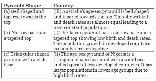
Match the following age-sex pyramids with their respective countries:
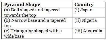
Detailed Solution for Geography: CUET Mock Test - 1 - Question 5

Thus, the correct answer is option d.

Geography: CUET Mock Test - 1 - Question 6

Who coined the term 'neo-determinism'?

Detailed Solution for Geography: CUET Mock Test - 1 - Question 6

An Australian geographer, Griffith Taylor, was the first to propound the concept of neo-determinism. Neo-determinism is also called "Stop and go determinism" because it believes that if human activities (pollution) cause long-term damage to the environment, then such activities should be stopped, otherwise humans can do everything that the environment allows them to do.

Geography: CUET Mock Test - 1 - Question 7

Directions: Match the contents under column I with those under column II.

Detailed Solution for Geography: CUET Mock Test - 1 - Question 7

Horses are used as a draught animal even in the Western countries. Dogs and reindeer are used in North America, North Europe and Siberia to draw sledges over snow-covered ground. Mules are preferred in the mountainous regions; while camels are used for caravan movement in deserts. In India, bullocks are used for pulling carts.

Geography: CUET Mock Test - 1 - Question 8

Which of the following is NOT an institutional or technological reform in agriculture?

Detailed Solution for Geography: CUET Mock Test - 1 - Question 8

Option 1 is not an example of institutional or technological reform. Options 2 and 4 are examples of institutional reforms. Option 3 is an example of technological reform in agriculture. Option 1 does not fall under the category of technological or institutional reforms. Following are the institutional and technological reforms undertaken in agriculture:
(i) Land reforms: Collectivisation, consolidation of holdings, cooperation and abolition of zamindari
(ii) Agricultural reforms: Green Revolution and White Revolution
(iii) Land development programmes: Procurement for crop insurance against drought, flood, cyclone, etc., establishment of Grameen banks, Cooperative societies and banks for providing loans
(iv) Issuing of Kissan Credit Card and Personal Accident Insurance Scheme, etc.
(v) Special weather bulletins and agricultural programmes for farmers on radio and TV

Geography: CUET Mock Test - 1 - Question 9

Which of the following is a sub-discipline of economic geography?

Detailed Solution for Geography: CUET Mock Test - 1 - Question 9

Economic geography is a sub-field of human geography which studies economic activity and factors affecting them. It can also be considered a sub-field or method in economics. There are four branches of economic geography - primary sector, secondary sector, tertiary sector, and quaternary sector.
Sub-fields of economic geography are: geography of resources, geography of agriculture, geography of tourism, geography of industries, geography of marketing and geography of international trade.

Geography: CUET Mock Test - 1 - Question 10

Which of the following statements is true regarding subsistence economy?

Detailed Solution for Geography: CUET Mock Test - 1 - Question 10

In a subsistence economy, goods are produced to provide for oneself or one's family.
A subsistence economy is an economy directed to basic subsistence (the provision of food, clothing, shelter) rather than to the market. "Subsistence" is understood as supporting oneself at a minimum level. Often, the subsistence economy is moneyless and relies on natural resources to provide for basic needs through hunting, gathering, and agriculture. In a subsistence economy, economic surplus is minimal and only used to trade for basic goods, and there is no industrialization.

Geography: CUET Mock Test - 1 - Question 11

Which of the following took place after the industrial revolution?

Detailed Solution for Geography: CUET Mock Test - 1 - Question 11

After the 'Industrial Revolution', the demand for raw materials like grains, meat, and wool expanded, but their monetary value declined in relation to the manufactured goods. The industrialised nations imported primary products as raw materials and exported the value added finished products back to the non-industrialised nations.

Geography: CUET Mock Test - 1 - Question 12

Which of the following approaches to human development considers the provision of health, education, food, water, supply, sanitation and housing?

Detailed Solution for Geography: CUET Mock Test - 1 - Question 12

The basic needs approach is one of the major approaches to the measurement of absolute poverty in developing countries. It attempts to define the absolute minimum resources necessary for long-term physical well-being, usually in terms of consumption goods. It was introduced at the International Labour Organization's World Employment Conference in 1976. A traditional list of immediate "basic needs" includes food (including water), shelter and clothing. Many modern lists also emphasise on sanitation, education, and healthcare.

Geography: CUET Mock Test - 1 - Question 13

Which city was the first to achieve the status of a mega city by 1950?

Detailed Solution for Geography: CUET Mock Test - 1 - Question 13

New York became the most populous urbanised area in the world in the early 1920s, overtaking London. The metropolitan area surpassed the 10 million mark in the early 1930s, becoming the first megacity in human history.

Geography: CUET Mock Test - 1 - Question 14

Arrange the following states in descending order according to population density:

Chandigarh, Puducherry, Lakshadweep, Delhi, Arunachal Pradesh

Detailed Solution for Geography: CUET Mock Test - 1 - Question 14

According to Census 2021, Delhi has the highest population density of 11,297 persons per square kilometre, followed by Chandigarh (9,252), Puducherry (2,598), and Lakshadweep (2,013). Arunachal Pradesh has the lowest density of 17 persons per square kilometre.

Geography: CUET Mock Test - 1 - Question 15

Which of following are popularly known as the 'Compact settlements'?

Detailed Solution for Geography: CUET Mock Test - 1 - Question 15

Compact/Nucleated settlements: These are the settlements in which large number of houses are built very close to each other. Such settlements develop along river valleys and in fertile plains. Communities are closely knit and share common occupations.

Geography: CUET Mock Test - 1 - Question 16

Which of the following is/are the economic factor(s) of population?

Detailed Solution for Geography: CUET Mock Test - 1 - Question 16

Economic factors of population mean the factors by which the positive growth of the individuals is affected by the economic development of the region. In case of minerals, industrialisation, and urbanisation, there is inter-linkage (exploration of minerals will result in interest in industrialisation, which will result in the urbanisation of society), resulting in economic development of the areas where the population is residing. Hence, option D is correct.

Geography: CUET Mock Test - 1 - Question 17

What was the approach of human geography during the early colonial period?

Detailed Solution for Geography: CUET Mock Test - 1 - Question 17

Exploration is the act of searching for the purpose of discovery of information or resources, especially in the context of geography or space, rather than research and development that is usually not centred on earth sciences or astronomy. The approach which gained importance during the early colonial period was of exploration and description.

Geography: CUET Mock Test - 1 - Question 18

Name the scholar who raised his voice about increasing population, in comparison to available food resources, in 1793?

Detailed Solution for Geography: CUET Mock Test - 1 - Question 18

Sir Robert Malthus was the first one to voice his concern about the growing scarcity of resources as compared to the human population. Thomas Malthus in his theory (1793) stated that the number of people would increase faster than the food supply. Any further increase would result in a population crash caused by famine, disease, and war. The preventive checks are better than the physical checks. For the sustainability of our resources, the world will have to control the rapid increase in population.

Geography: CUET Mock Test - 1 - Question 19

Which type of farming involves both the growing of crops and the raising of livestock?

Detailed Solution for Geography: CUET Mock Test - 1 - Question 19

It is a type of farming which includes simultaneous growing of crops and the raising of livestock. Mixed farms are moderate in size.

Geography: CUET Mock Test - 1 - Question 20

Directions: Read the following passage carefully:

The pressure on land resources is increasing with more demand for food production. This has forced farmers to develop land for agriculture production and adopt intensive and unsustainable land-use techniques that can cause high levels of soil erosion. Increasing pressures of urbanisation and industrialisation and anthropogenic activities such as building of roads, dams, construction activities are also increasing the rate of erosion of the soil in India. The different kinds and increasing extent of erosion contribute to rapid conversion of cultivable lands into wastelands. For example, recent evidence shows that about 20% of the total geographical area of the country has been converted into wastelands.
Since the causes of soil erosion differ from one area to the other, different methods such as contour tillage, contour bunding, construction of check dams, terrace farming etc are used to prevent erosion and improve soil quality.
Source: Indiawaterportal.org, Aarti Kelkar Khambete, 2021.

Q. Which category of land use will increase due to soil erosion?

Detailed Solution for Geography: CUET Mock Test - 1 - Question 20

Barren lands: They are the lands which may be classified as wastelands, such as barren hilly terrains, desert lands, ravines, etc. Normally, these lands cannot be brought under cultivation with the available technology. Rapid soil erosion leads to cultivable lands becoming wastelands. The answer can be explicitly inferred from 'The different kinds and increasing . . . into wastelands.' Thus, option C is correct.

Geography: CUET Mock Test - 1 - Question 21

Population explosion occurs due to

Detailed Solution for Geography: CUET Mock Test - 1 - Question 21

Population explosion:

  • Population Explosion is a sudden, large increase in the size of a population.
  • The major factors that are responsible for population explosion are illiteracy, reduced mortality, increased birth rate/fertility
  • Improved medicare facility is one of the major causes of the population explosion.
  • The most simple method to control population explosion is to encourage small families about different control measures such as contraceptives.
  • Periodic abstinence is the natural measure for control.
  • It refers to the rapid increase in the population of an area among human beings.
  • Furthermore, it is a situation where the economy is not capable of coping with the increasing demand of its population.

Causes of population explosion:

  • Falling Mortality Rate
  • High birth rate
  • The imbalance between births and deaths.
  • Lack of Female Education
  • Underutilized contraception

Hence, the population explosion occurs due to High Birth Rates as well as Low Death rates.

Geography: CUET Mock Test - 1 - Question 22

The east-west corridor has the easternmost section-Easternmost section in the east-west corridor is-

Detailed Solution for Geography: CUET Mock Test - 1 - Question 22

The North-South–East-West Corridor (NS-EW) is the largest ongoing highway project in India.

  • East end: Silchar.
  • West end: Porbandar.
  • North end: Srinagar.
  • South end: Kanyakumari/Kochi.
Geography: CUET Mock Test - 1 - Question 23

Which of the following can be categorized as a primary activity?

Detailed Solution for Geography: CUET Mock Test - 1 - Question 23

Activities that generate income are termed economic activities. On the basis of economic activities, the Indian economy can be divided into 3 major sectors that are the primary sector, the secondary sector, and the tertiary sector. There are two other sectors also, called quaternary and quinary activity.

Geography: CUET Mock Test - 1 - Question 24

Which one of the following is the example of subsistence farming?

Detailed Solution for Geography: CUET Mock Test - 1 - Question 24

Subsistence agriculture/farming:

  • It is when farmers grow food crops to meet the needs of themselves and their families only with little or no surplus production.
  • Shifting cultivation is an agricultural practice in which a piece of land(forest or abandoned) is cleared for agricultural purposes and once the land becomes inadequate/infertile for crop production, it is abandoned to be reclaimed by natural vegetation. Hence, Option 1 is correct.
  • Shifting cultivation is practiced in the thickly forested areas of the Amazon basin, tropical Africa, parts of Southeast Asia, and Northeast India.
  • These are the areas of heavy rainfall and quick regeneration of vegetation.
  • A plot of land is cleared by felling the trees and burning them.
  • The ashes are then mixed with the soil and crops like maize, yam, potatoes, and cassava are grown.
  • After the soil loses its fertility, the land is abandoned and the cultivator moves to a new plot. Shifting cultivation is also known as ‘slash and burn agriculture.
  • Subsistence farming is self-sufficiency farming in which the farmers grow enough food to feed themselves and their families.
  • It is mostly practiced in developing countries.
  • Shifting cultivation is a type/ example of subsistence farming in which the farmers clear a patch of forest land by cutting and burning trees and then crops are grown.
  • This type of farming is practiced to meet the needs of the farmer’s family. Traditionally, low levels of technology and household labor are used to produce small output.
  • Subsistence farming can be further classified as intensive subsistence and primitive subsistence farming.
Geography: CUET Mock Test - 1 - Question 25

The Lorraine Region of France is famous for:

Detailed Solution for Geography: CUET Mock Test - 1 - Question 25

Lorraine is famous worldwide for its quiche, macarons, Mirabelle plum, and madeleine.

  • It is home to more than 2.3 million inhabitants (Lorrains and Lorraine's).
  • For many years, the region was synonymous with coal, iron, and steel industries and was in 1960 the 3rd economical region in France.
Geography: CUET Mock Test - 1 - Question 26

The earliest Iron and Steel Company to be established in India was:

Detailed Solution for Geography: CUET Mock Test - 1 - Question 26

Tata iron and steel Company

  • The first and one of the largest manufacturing plants in Asia is Tata Iron and Steel Company, also known as TISCO.
  • Tata iron and steel Company is situated in Jharkhand which was founded by Jamsetji Tata in 1907 and is the oldest steel plant in India. Hence, Option 2 is correct.
  • Tata Iron and Steel Company or TISCO is the first iron and steel manufacturing plant in India which was founded and established by Jamsetji Tata and Dorabji Tata respectively on 26th August 1907 at Jamshedpur, Jharkhand.
  • Tata iron and steel Company started production of pig iron in the year 1911 and production of steel in the year 1912.
  • Tata iron and steel Company made rapid progress during the First World War and by 1939, the largest steel plant was operated by Tata iron and steel Company within the British Empire.
  • The establishment of Tata Iron and Steel Company at Jamshedpur includes various advantages like it is near to deposits of coal and manganese, iron ores, and even to Kolkata which provided a large market.
  • An adequate water supply is ensured by the rivers Kharkai and Subarnarekha.
  • The headquarters of Tata iron and steel company is in Mumbai, Maharashtra and its marketing headquarters are situated in Kolkata and West Bengal.
  • Its manufacturing operations are present in 26 countries which include India, Australia, United Kingdom, United Arab Emirates, Malaysia, France, Canada, etc.
  • The iron and steel manufactured by Tata iron and steel Company are utilized in construction, automation, engineering, lifting and excavation, defense and security sectors, and many more.
  • The first iron and steel plant in India was established at Jamshedpur city in Jharkhand state.
Geography: CUET Mock Test - 1 - Question 27

Which of the following industries is not a heavy industry?

Detailed Solution for Geography: CUET Mock Test - 1 - Question 27

The industry is a category of active enterprises and organizations which produce or sell products, services, or sources of revenue. Industries are commonly categorized in economics as the primary industry, secondary industry and tertiary industry.

Geography: CUET Mock Test - 1 - Question 28

What do you understand by Sex ratio?

Detailed Solution for Geography: CUET Mock Test - 1 - Question 28

The ratio between the number of women and men in the population per 1000 is called the Sex Ratio.

  • The sex ratio is an important information about the status of women in a country. 
  • In regions where gender discrimination is rampant, the sex ratio is bound to be unfavourable to women.
Geography: CUET Mock Test - 1 - Question 29

Which of the following canals is used as an inland waterway in Southern Germany ?

Detailed Solution for Geography: CUET Mock Test - 1 - Question 29

The Ludwig canals are used as an inland waterway in Southern Germany.

  • The canal linked the Danube River at Kelheim with the Main River at Bamberg, connecting the Danube basin with the Rhine basin.
  • The first realisation of a dream to enable barges to navigate from the North Sea to the Black sea.
  • The Ludwig Canal proved to be unsustainable and was eventually succeeded by a larger canal, over a century later.
  • Today, there still exists between Nuremberg and Berching some 60 km of the canal in good condition.
  • Some of the locks still function, and part of the towpath has been converted to a cycle track.
  • The old canal comes close to the new canal at Pollanten, and from there the two canals flow downstream in parallel, eventually meeting 5km south of Berching.

Hence, option C is correct.

Geography: CUET Mock Test - 1 - Question 30

On which river and between which two places does the National Water Way No. 1 lie?

Detailed Solution for Geography: CUET Mock Test - 1 - Question 30
  • India has about 14500 km of navigable waterways including rivers, backwaters, canals etc.
  • In 1986, the Government of India created the Inland Waterways Authority of India (IWAI) for the regulation and development of Inland Waterways for navigation and shipping.
    • Headquarters: Noida.
  • In March 2016, the National Waterways Act, 2016 was enacted.
    • It created 106 new waterways on rivers, estuaries, creeks, backwaters and canals in the country. 
  • Currently, 13 NWs are operational for shipping and navigation and cargo/passenger vessels are moving on them.
  • NW – 1 is on the Ganga-Bhagirathi-Hooghly river from Prayagraj to Haldia having a length of 1620km stretching in Uttar Pradesh, Bihar, Jharkhand, West Bengal. Hence, option 2 is correct.
View more questions
Information about Geography: CUET Mock Test - 1 Page
In this test you can find the Exam questions for Geography: CUET Mock Test - 1 solved & explained in the simplest way possible. Besides giving Questions and answers for Geography: CUET Mock Test - 1, EduRev gives you an ample number of Online tests for practice

Top Courses for Humanities/Arts

Download as PDF

Top Courses for Humanities/Arts