CRPF Head Constable Mock Test - 8 - CDS MCQ
30 Questions MCQ Test - CRPF Head Constable Mock Test - 8
Directions: Study the following information carefully to answer the given Questions:
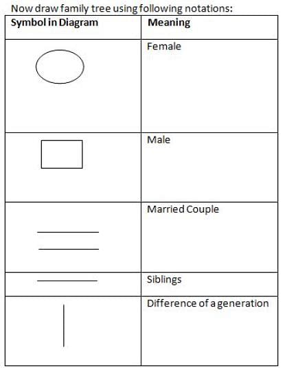
P^Q-P is the child of Q
P!Q-P is the parent of Q
P*Q - P is elder to Q
P#Q-P is younger to Q
P@Q-P is brother of Q
P&Q - P is wife of Q
P+Q-P is sister-in-law of Q
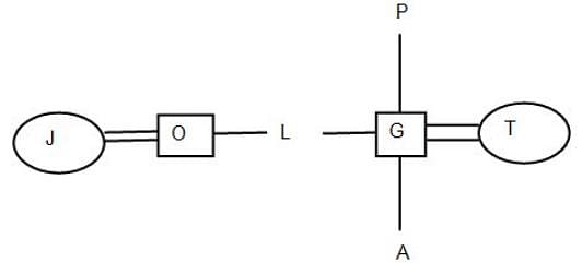
Q. If G! A^T+J&O@L^P! G, then how is J related to A?
P!Q-P is the parent of Q
P*Q - P is elder to Q
P#Q-P is younger to Q
P@Q-P is brother of Q
P&Q - P is wife of Q
P+Q-P is sister-in-law of Q
In this following question, four words have been given, out of which three are alike in some manner and the fourth one is different. Choose out the odd one out.
| 1 Crore+ students have signed up on EduRev. Have you? Download the App |
Directions to Solve
In each of the following questions find out the alternative which will replace the question mark.
Question -
KeaC : CaeK :: XgmF : ?
The rows and columns of the left matrix have been labelled as 5, 6, 7, 8, 9 and F, G, H, I, J, whereas those of the right matrix are 0, 1, 2, 3, 4 and K, L, M, N, O. Find the correct row-column pairs out of these matrices that decode to the word - NKS8
Direction: In each question below is given a statement followed by two conclusions numbered I and II. You have to assume everything in the statement to be true, then consider the two conclusions together and decide which of them logically follows beyond a reasonable doubt from the information given in the statement.
Statements: Vegetable prices are soaring in the market.
Conclusions:
- Vegetables are becoming a rare commodity.
- People cannot eat vegetables.
Direction: In each question below is given a statement followed by two conclusions numbered I and II. You have to assume everything in the statement to be true, then consider the two conclusions together and decide which of them logically follows beyond a reasonable doubt from the information given in the statement.
Statements: This world is neither good nor evil; each man manufactures a world for himself.
Conclusions:
- Some people find this world quite good.
- Some people find this world quite bad.
Directions: Study the following information carefully and answer the given questions.
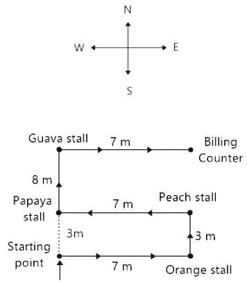
Virat goes to Supermarket store to buy fruits. He enters the market, turns to his right, walks 7m and takes oranges. Then, he turns to his left, walks 3m and takes Peach. Again, he turns to his left, which is towards west, walks 7m and takes Papayas. Again, he turns to his right and looks at guavas, which 8m away from him. He takes guavas and moves to his right, walks 7m and stops at the counter for billing.
Q. How far is the Papaya stall from the starting point?
The average of 10 two-digit positive integers is Z. However, one number AB is taken as BA, then the average increases to Z + 2.7. What is the value of |B - A|?
At what percentage per annum, will Rs. 10,000 amount to 17,280 in three years? (Compound Interest being reckoned)
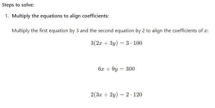
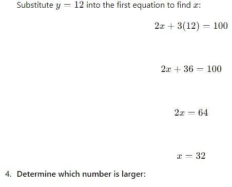
Two numbers such that the sum of twice the first number and thrice the second number is 100 and the sum of thrice the first number and twice the second number is 120. Which is larger number?
A purse contains notes of Re. 1, Rs. 10 and Rs. 20 only. The number of notes of Re. 1 is seven times the number of notes of Rs. 10 and the number of notes of Rs. 20 is 4 times the number of notes of Rs. 10. How much money is there in the purse if there are total twelve notes of Rs. 20?
A sold a watch to B at a gain of 5% and B sold it to C at a gain of 4%. If C paid Rs. 1,092 for it, the price paid by A is
If 350 stones of spherical shape are dropped into a hemispherical cup containing some water, they get fully submerged. Diameter of the cup is 14 m. What will be the radius of the stone, if the water just spills off from the hemispherical cup?
Find out the Synonym of the following word:
INEBRIATE
Find the word most appropriate for Blank no. 20
The (11)____ citizen who has to get everyday jobs done by various municipal and government departments is (12)____ driven up a tree, first (13)____ them, second explaining to them what is (14)____ and lastly, getting the job done.
If this week I (15)____ some personal experience in this column, it is because I can document them. It is not to ask for any special (16)____ or voice personal (17)____ but to bring into public view the experience of hundreds, if not thousands of citizens everyday of the year and express the collective (18)____ of all of them. Because one’s usual experience is that when such complaints are (19)____ in such columns, the departments rush to (20)____
Find the word most appropriate for Blank no. 29
Our study about women’s place in Indian society is mainly based on urban, professional and educated Indian women. Deep in the rural heartland of the country, the rapidly changing world has not even touched the (29)____ of the life of a women. Most men of orthodox families take (30)____ in revealing that their (31)____ folk stay in ‘purdah’, a shield that (32)____ a woman of the joys of free nature. Still more alarming are the (33)____ of atrocities of women (34)____ incidents at Bantala, Singur and Birati are (35)____
Directions: In the given statements, a blank has been given. This needs to be filled up using the correct combination of words from the three options mentioned, so that the resulting statement is grammatically and contextually correct.
In the ancient times, remaining alone was dangerous as _______________ animals could easily attack its solitary prey.
I. domesticated
II. wild
III. herbivorous
Which one best expresses the given sentence in Passive/Active Voice?
Has someone made all the necessary arrangements?
Direction: The sentences given in the question, when properly sequenced, form a coherent paragraph. Each sentence is labeled with a letter. Choose the most logical order of sentences from the given choices to construct a coherent paragraph.
A. Not long after their victory, the Greeks began to think that they would never stack up to the glories of the past.
B. Throughout antiquity, those warriors, especially the Marathonomachai, who fought and defeated the Persian troops in the 490 BCE Battle of Marathon, would be revered as Athens’ Greatest Generation.
C. Even in the mid-fifth century BCE, Athenians were already looking back with longing.
D. A few decades earlier, Athenian citizen-soldiers had helped to rout the Persian invaders of Greece.
Directions: Read the following passage carefully and answer the questions given beside.
Remote sensing and GIS are promising tools for handling spatial and temporal data and help in integrating them for successful planning of natural resources. It is the science of measuring the earth using sensors mounted on high-flying aircrafts or satellites. These sensors collect data in the form of images and provide insights for manipulating, analysing and visualising those images. Since natural resources are not uniformly distributed and are spatially varied, it is challenging to capture the correct picture. Management of natural resources calls for scientific tools for timely and accurate dissemination of information. In natural resource management, remote sensing and GIS are mainly used in the mapping process. These techniques are useful in management of land, soil, coastal, watershed, urban and many more.
In India, the agriculture sector alone sustains the livelihood of around 50 percent of the population. Therefore, an increase in crop productivity has been a major concern. Since, the scope for increasing area under agriculture is limited, advanced crop production forecasting is required for better policymaking. Indian Space Research Agency (ISRO) and Indian Council of Agricultural Research (ICAR) successful experiment-Agricultural Resource Inventory and Survey Experiment (ARISE) used aerial colour photographs to estimate crop acreage in many states of India. Other Important uses of remote sensing include crop identification, stress detection, and crop yield modelling, drought monitoring, land degradation mapping and more. Urbanisation is important and inevitable for development, but its proper planning and management is crucial for sustenance. One of the important features of GIS is multilayered mapping. This kind of mapping helps municipal corporations, town planning boards to build cities that are better organised. The information systems with socio-economic data overlaid upon satellite data makes urban planning cost-effective and accurate.
Coastal ecosystems have high ecological significance. GIS and remote sensing data are used to study coastal ecosystems and marine living resources which include habitats like mangroves, coral reefs and more. Apart from this, suspended shoreline dynamics can be studied and climatic changes leading to cyclones and sea level rise may be of special interest too. Geospatial data is effective in the analysis and determination of factors that affect the utilisation of these resources. The technologies provide a platform through which we can generate information that can be used to make sound decisions for sustainable development of the natural resources of India.
Q. How effective are remote sensing and GIS in managing urban growth?
I. GIS and remote sensing are helpful in building cities that are better organized.
II. The system makes urban planning cost-effective and accurate.
III. They help the government disseminate people living in extremely densed areas to less populated ones.
Directions: Read the following passage carefully and answer the questions given beside.
Remote sensing and GIS are promising tools for handling spatial and temporal data and help in integrating them for successful planning of natural resources. It is the science of measuring the earth using sensors mounted on high-flying aircrafts or satellites. These sensors collect data in the form of images and provide insights for manipulating, analysing and visualising those images. Since natural resources are not uniformly distributed and are spatially varied, it is challenging to capture the correct picture. Management of natural resources calls for scientific tools for timely and accurate dissemination of information. In natural resource management, remote sensing and GIS are mainly used in the mapping process. These techniques are useful in management of land, soil, coastal, watershed, urban and many more.
In India, the agriculture sector alone sustains the livelihood of around 50 percent of the population. Therefore, an increase in crop productivity has been a major concern. Since, the scope for increasing area under agriculture is limited, advanced crop production forecasting is required for better policymaking. Indian Space Research Agency (ISRO) and Indian Council of Agricultural Research (ICAR) successful experiment-Agricultural Resource Inventory and Survey Experiment (ARISE) used aerial colour photographs to estimate crop acreage in many states of India. Other Important uses of remote sensing include crop identification, stress detection, and crop yield modelling, drought monitoring, land degradation mapping and more. Urbanisation is important and inevitable for development, but its proper planning and management is crucial for sustenance. One of the important features of GIS is multilayered mapping. This kind of mapping helps municipal corporations, town planning boards to build cities that are better organised. The information systems with socio-economic data overlaid upon satellite data makes urban planning cost-effective and accurate.
Coastal ecosystems have high ecological significance. GIS and remote sensing data are used to study coastal ecosystems and marine living resources which include habitats like mangroves, coral reefs and more. Apart from this, suspended shoreline dynamics can be studied and climatic changes leading to cyclones and sea level rise may be of special interest too. Geospatial data is effective in the analysis and determination of factors that affect the utilisation of these resources. The technologies provide a platform through which we can generate information that can be used to make sound decisions for sustainable development of the natural resources of India.
Q. Why, according to the passage, are GIS and remote sensing considered as promising tools?
I. They collect data in the form of graphs.
II. They provide scope for manipulating, analyzing and visualizing the images.
III. They disseminate data’s more accurately.
Directions: Read the following passage carefully and answer the questions given beside.
Remote sensing and GIS are promising tools for handling spatial and temporal data and help in integrating them for successful planning of natural resources. It is the science of measuring the earth using sensors mounted on high-flying aircrafts or satellites. These sensors collect data in the form of images and provide insights for manipulating, analysing and visualising those images. Since natural resources are not uniformly distributed and are spatially varied, it is challenging to capture the correct picture. Management of natural resources calls for scientific tools for timely and accurate dissemination of information. In natural resource management, remote sensing and GIS are mainly used in the mapping process. These techniques are useful in management of land, soil, coastal, watershed, urban and many more.
In India, the agriculture sector alone sustains the livelihood of around 50 percent of the population. Therefore, an increase in crop productivity has been a major concern. Since, the scope for increasing area under agriculture is limited, advanced crop production forecasting is required for better policymaking. Indian Space Research Agency (ISRO) and Indian Council of Agricultural Research (ICAR) successful experiment-Agricultural Resource Inventory and Survey Experiment (ARISE) used aerial colour photographs to estimate crop acreage in many states of India. Other Important uses of remote sensing include crop identification, stress detection, and crop yield modelling, drought monitoring, land degradation mapping and more. Urbanisation is important and inevitable for development, but its proper planning and management is crucial for sustenance. One of the important features of GIS is multilayered mapping. This kind of mapping helps municipal corporations, town planning boards to build cities that are better organised. The information systems with socio-economic data overlaid upon satellite data makes urban planning cost-effective and accurate.
Coastal ecosystems have high ecological significance. GIS and remote sensing data are used to study coastal ecosystems and marine living resources which include habitats like mangroves, coral reefs and more. Apart from this, suspended shoreline dynamics can be studied and climatic changes leading to cyclones and sea level rise may be of special interest too. Geospatial data is effective in the analysis and determination of factors that affect the utilisation of these resources. The technologies provide a platform through which we can generate information that can be used to make sound decisions for sustainable development of the natural resources of India.
Q. What is the tone of the author?
Directions: Read the following passage carefully and answer the questions given beside.
Remote sensing and GIS are promising tools for handling spatial and temporal data and help in integrating them for successful planning of natural resources. It is the science of measuring the earth using sensors mounted on high-flying aircrafts or satellites. These sensors collect data in the form of images and provide insights for manipulating, analysing and visualising those images. Since natural resources are not uniformly distributed and are spatially varied, it is challenging to capture the correct picture. Management of natural resources calls for scientific tools for timely and accurate dissemination of information. In natural resource management, remote sensing and GIS are mainly used in the mapping process. These techniques are useful in management of land, soil, coastal, watershed, urban and many more.
In India, the agriculture sector alone sustains the livelihood of around 50 percent of the population. Therefore, an increase in crop productivity has been a major concern. Since, the scope for increasing area under agriculture is limited, advanced crop production forecasting is required for better policymaking. Indian Space Research Agency (ISRO) and Indian Council of Agricultural Research (ICAR) successful experiment-Agricultural Resource Inventory and Survey Experiment (ARISE) used aerial colour photographs to estimate crop acreage in many states of India. Other Important uses of remote sensing include crop identification, stress detection, and crop yield modelling, drought monitoring, land degradation mapping and more. Urbanisation is important and inevitable for development, but its proper planning and management is crucial for sustenance. One of the important features of GIS is multilayered mapping. This kind of mapping helps municipal corporations, town planning boards to build cities that are better organised. The information systems with socio-economic data overlaid upon satellite data makes urban planning cost-effective and accurate.
Coastal ecosystems have high ecological significance. GIS and remote sensing data are used to study coastal ecosystems and marine living resources which include habitats like mangroves, coral reefs and more. Apart from this, suspended shoreline dynamics can be studied and climatic changes leading to cyclones and sea level rise may be of special interest too. Geospatial data is effective in the analysis and determination of factors that affect the utilisation of these resources. The technologies provide a platform through which we can generate information that can be used to make sound decisions for sustainable development of the natural resources of India.
Q. What can be the most appropriate title for the passage?
The opinions and the comments about the working of the government are also expressed through media like
Which one of the following is a viral disease in man?
Potassium Permanganate is used for purifying drinking water, because -


