Software Development Exam  >  Software Development Tests  >  Test: Climate - Software Development MCQ

Test: Climate - Software Development MCQ


Test Description

10 Questions MCQ Test - Test: Climate

Test: Climate for Software Development 2025 is part of Software Development preparation. The Test: Climate questions and answers have been prepared according to the Software Development exam syllabus.The Test: Climate MCQs are made for Software Development 2025 Exam. Find important definitions, questions, notes, meanings, examples, exercises, MCQs and online tests for Test: Climate below.
Solutions of Test: Climate questions in English are available as part of our course for Software Development & Test: Climate solutions in Hindi for Software Development course. Download more important topics, notes, lectures and mock test series for Software Development Exam by signing up for free. Attempt Test: Climate | 10 questions in 12 minutes | Mock test for Software Development preparation | Free important questions MCQ to study for Software Development Exam | Download free PDF with solutions
Test: Climate - Question 1

The average pattern of wind speed, temperature, rainfall etc., in place over a long period of time is called ___________.

Detailed Solution for Test: Climate - Question 1

The correct answer is Climate.

Key Points

  • The average pattern of wind speed, temperature, rainfall, etc, in place over a long period of time, is called climate.
  • Climate is the average weather in a place over many years.
  • The weather can change in just a few hours whereas climate takes millions of years to change.
  • Planet earth has witnessed many variations in climate since the beginning.
  • There are several causes of climate change.
  • The most significant anthropogenic effect on the climate is the increasing trend in the concentration of greenhouse gases in the atmosphere.
Test: Climate - Question 2

What is the full form of ITCZ?

Detailed Solution for Test: Climate - Question 2

The full form of ITCZ is The Intertropical Convergence Zone.

  • It is the area encircling Earth near the Equator, where there is a convergence of the northeast and southeast trade winds takes place.
  • The ITCZ was originally identified from the 1920s to the 1940s as the "Intertropical Front" but after the recognition in the 1940s and 1950s of the significance of wind field convergence in tropical weather production.
Test: Climate - Question 3

Mansoon arrives in India approximately in:

Detailed Solution for Test: Climate - Question 3

Key Points

Monsoon in India:

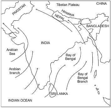
  • The southwest monsoon sets in over the Kerala coast by 1st June and moves swiftly to reach Mumbai and Kolkata between 10th and 13th June.
  • By mid-July, southwest monsoon engulfs the entire subcontinent
  • During April and May when the sun shines vertically over the Tropic of Cancer, the large landmass in the north of the Indian ocean gets intensely heated.
  • This causes the formation of intense low pressure in the northwestern part of the subcontinent.
  • Since the pressure in the Indian Ocean in the south of the landmass is high as the water gets heated slowly, the low-pressure cell attracts the southeast trades across the Equator.
  • These conditions help in the northward shift in the position of the ITCZ.
  • The southwest monsoon may thus, be seen as a continuation of the southeast trades deflected towards the Indian subcontinent after crossing the Equator.
  • These winds cross the Equator between 40°E and 60°E longitudes.
  • The shift in the position of the ITCZ is also related to the phenomenon of the withdrawal of the westerly jet stream from its position over the north Indian plain, south of the Himalayas.
  • The easterly jet stream sets in along 15°N latitude only after the western jet stream has withdrawn itself from the region.
  • This easterly jet stream is held responsible for the burst of the monsoon in India.

Hence, the Mansoon arrives in India approximately in early June.

Test: Climate - Question 4

Match List 1 and List 2 and select the correct answer.

Detailed Solution for Test: Climate - Question 4

The correct answer is A - 4, B - 1, C - 2, D - 3.

Key Points

  • Local winds of India
    • Mango showers - in Kerala for the growth of mangoes.
    • Loo - hot dry winds from Rajasthan to western UP
    • Kalbaishakhi - thunderstorms in West Bengal and Assam
    • Winter Rainfall - Tamil Nadu receives rainfall in winter because of the retreating monsoon.

Additional Information

  • Local Winds around the world
    • Chinook (snow eaters) - Rockies mountain
    • Foehn - Alps (hot dry)
    • Khamsin (Hot dry) - Egypt
    • Bora (cold-dry) - Hungary to North Italy
    • Blizzard (cold) - Tundra region
    • Norwester (hot) - New Zealand
    • Purga (cold) - Russia
Test: Climate - Question 5
Main causes of origin of Monsoon -
Detailed Solution for Test: Climate - Question 5

The correct answer is All of these.

Key Points

  • Jet Streams develop where air masses of differing temperatures meet.
  • El Nino:
    • El Nino refers warming of sea surface temperatures across the central and east-central Equatorial Pacific.
    • El Nino is associated with high pressure in the western Pacific.
    • El Nino is the opposite of La Nina.
    • Rainfall follows the warm water eastward, with associated flooding in Peru and drought in Indonesia and Australia.
    • El Nino adversely impacts the Indian monsoons and hence, agriculture in India.
  • Equatorial low-pressure belt:
    • This belt extends from the equator to 100 N and 100 S latitudes.
    • The intertropical convergence zone (ITCZ) is known as the region of convergence near the equator because the winds flowing from subtropical high-pressure belts converge here.
      • Water vapor condenses as air rises and cools in the ITCZ, forming clouds and falling as rain. 
    • This low-pressure belt is also known as doldrums because it is a zone of total calm without any winds.
    • Due to high temperatures, a low-pressure belt is created in the equatorial region.
    • This gives rise to air convergence in the area.
  • Southwest monsoons winds:
    • India receives most of its rainfall from the southwest monsoon winds.
    • 'Southwest Monsoon' period is referred to as the period between June to September.
    • South West monsoons are the rain-bearing seasonal winds that flow from the Arabian Sea towards India's mainland in the South-West direction.
  • North-east monsoons:
    • When winds move back from the land to the sea, it is known as retreating monsoons. 
    • Retreating monsoons are also called north-east monsoons. 
    • October to December is referred to as the period of North-east monsoons
    • They start with the withdrawal of southwest monsoons.
    • The Tamilnadu receives the highest rainfall from the North-East monsoon.
Test: Climate - Question 6
The state having the highest rainfall by North-East monsoon is_______________.
Detailed Solution for Test: Climate - Question 6

The correct answer is Option(3).i.e.Tamil Nadu.

Key Points:

  • The state has the highest rainfall by North-East monsoon in Tamil Nadu. 
  • Nort-East Monsoon: 
    • The north-east monsoon, generally known as a monsoon of winter which blows from the land towards the sea and south-west monsoon is just the opposite, known as a monsoon of summer which blows from sea to land.
    • The North-East monsoon usually occurs within October to March, although it may change every year. 

 North-east monsoons are called as retreating monsoons

Test: Climate - Question 7
Which one of the following causes rainfall during winters in north-western part of India.
Detailed Solution for Test: Climate - Question 7

The correct answer is Western disturbances.

Key Points

The western cyclonic disturbances are weather phenomena of the winter months brought in by the westerly flow from the Mediterranean region.

  • They usually influence the weather of the north and north-western regions of India.
  • Tropical cyclones occur during the monsoon, as well as, in October-November, and are part of the easterly flow.
  • These disturbances affect the coastal regions of the country.
  • Thus, we can conclude that Western disturbances cause rainfall during winters in the north-western part of India.

Important Points

  • Retreating means withdrawal. So, the withdrawal of southwest monsoon winds from the skies of north India during the months of October and November is known as the retreating monsoon.
  • The period of June to September is referred to as the 'Southwest Monsoon' period. The Southwest Monsoon period is the principal rainy season for the Indian subcontinent. This is the summer monsoon period where the southwest monsoon holds away over the country.
Test: Climate - Question 8
In India, the maximum amount of rainfall is received from
Detailed Solution for Test: Climate - Question 8

The correct answer is South-West Monsoon.

  • Air moves from the high-pressure area over the southern Indian Ocean, in a south-easterly direction, crosses the equator and turns right towards the low-pressure areas over the Indian subcontinent. 
  • These are known as the Southwest Monsoon winds responsible for widespread rainfall in mainland India.
  • Due to the shift of ITCZ, the trade winds of the southern hemisphere cross the equator between 40° and 60°E longitudes and start blowing from southwest to northeast due to the Coriolis force. It becomes southwest monsoon.
  • In winter, the ITCZ moves southward, and so the reversal of winds from northeast to south and southwest takes place. They are called northeast monsoons.
  • The western cyclonic disturbances are weather phenomena of the winter months brought in by the westerly flow from the Mediterranean region.
  • They usually influence the weather of the north and north-western regions of India
  • The season of retreating monsoon (October and November) is a period of transition between the warm rainy monsoon and the dry cool winter.
Test: Climate - Question 9
Which of the following is not among the six major controls of the climate in India?
Detailed Solution for Test: Climate - Question 9

The correct answer is option 4 i.e. Population.

  • Climate refers to the sum total of weather conditions and variations over a large area for a long period of time (more than thirty years).
  • Weather refers to the state of the atmosphere over an area at any point of time.
  • There are six major controls of the climate of any place as explained below: 
  • Latitude
    • Due to the curvature of the earth, the amount of solar energy received varies according to latitude.
    • As a result, air temperature generally decreases from the equator towards the poles.
  • Altitude
    • As one goes from the surface of the earth to higher altitudes, the atmosphere becomes less dense and temperature decreases.
    • The hills are therefore cooler during summers.
  • Pressure and Wind System 
    • The pressure and wind system of any area depend on the latitude and altitude of the place.
    • Thus it influences the temperature and rainfall pattern.
  • Distance from the sea (continentality)
    • The sea exerts a moderating influence on climate: As the distance from the sea increases, its moderating influence decreases and the people experience extreme weather conditions.
    • This condition is known as continentality (i.e. very hot during summers and very cold during winters).
  • Ocean currents
    • Ocean currents along with onshore winds affect the climate of the coastal areas.
    •  For example, any coastal area with warm or cold currents flowing past it, will be warmed or cooled if the winds are onshore. 
  • Relief features 
    • Finally, relief too plays a major role in determining the climate of a place.
    • High mountains act as barriers for cold or hot winds; they may also cause precipitation if they are high enough and lie in the path of rain-bearing winds.
    • The leeward side of mountains remains relatively dry.
Test: Climate - Question 10

Which place in India has the highest rainfall?

Detailed Solution for Test: Climate - Question 10

Mawsynram, Meghalaya:

  • Mawsynram place in India has the highest average rainfall recorded.
  • Mawsynram has a subtropical highland climate.
  • Mawsynram receives nearly 10,000 millimetres of rain in an average year.
  • Mawsynram is located in the East Khasi Hills district of Meghalaya.
  • It is on the windward side of the hills and is surrounded by hills on three sides.
  • It receives rain from southwest monsoon winds (Bay of Bengal branch), as the winds cannot move further striking the hills and due to condensation receives heavy rainfall.

Thus, Mawsynram in India has the highest rainfall.

Important Point

  • The average rainfall in Bengaluru is 776.6 mm
  • The average rainfall in Mysore is 500 mm.
  • The average rainfall in Srinagar is 720 mm.

Additional Information

Information about Test: Climate Page
In this test you can find the Exam questions for Test: Climate solved & explained in the simplest way possible. Besides giving Questions and answers for Test: Climate, EduRev gives you an ample number of Online tests for practice
Download as PDF