Software Development Exam  >  Software Development Tests  >  Test: General Awareness (World Geography) - Software Development MCQ

Test: General Awareness (World Geography) - Software Development MCQ


Test Description

10 Questions MCQ Test - Test: General Awareness (World Geography)

Test: General Awareness (World Geography) for Software Development 2025 is part of Software Development preparation. The Test: General Awareness (World Geography) questions and answers have been prepared according to the Software Development exam syllabus.The Test: General Awareness (World Geography) MCQs are made for Software Development 2025 Exam. Find important definitions, questions, notes, meanings, examples, exercises, MCQs and online tests for Test: General Awareness (World Geography) below.
Solutions of Test: General Awareness (World Geography) questions in English are available as part of our course for Software Development & Test: General Awareness (World Geography) solutions in Hindi for Software Development course. Download more important topics, notes, lectures and mock test series for Software Development Exam by signing up for free. Attempt Test: General Awareness (World Geography) | 10 questions in 10 minutes | Mock test for Software Development preparation | Free important questions MCQ to study for Software Development Exam | Download free PDF with solutions
Test: General Awareness (World Geography) - Question 1

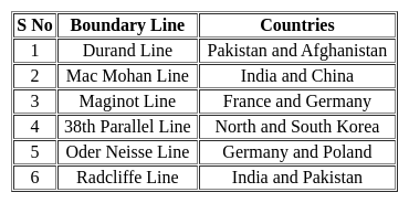
Maginot line exists between which country?

Detailed Solution for Test: General Awareness (World Geography) - Question 1

The correct answer is ​France and Germany.

Key Points

  • Maginot Line is a Defensive line in France.
  • It was constructed in 1930.
  • The Maginot Line was an extremely well-developed chain of fortifications for defence against the German attack during the first world war.

Additional Information

Test: General Awareness (World Geography) - Question 2

Which is the largest river island in the world?

Detailed Solution for Test: General Awareness (World Geography) - Question 2

The correct answer is Majuli island.

Important Points

  • The Guinness Book of World Records has named Majuli as the world's largest river island.
  • The beautiful river island is located on the River Brahmaputra in Assam.
  • It is formed by the Brahmaputra River in the South, and Kherkutia Xuti, an anabranch of Brahmaputra, joined by the Subansiri River in the north.
  • The island is populated by the Mising, Deori, and Sonowal Kachri tribes. 
  • The people of the island speak the languages of Mising, Assamese, and Deori.
  • It is home to about 1,60,000 individuals and is a hub of neo-Vaishnavite Assamese culture. 
  • It covers about 880 sq km of land and is one of Assam's popular tourist destinations.
  • Majuli suffers from heavy erosion due to the regular flooding of the Brahmaputra river.
  • It is estimated that it has lost approximately one-third of its territory in the last 30-40 years due to erosion.  
  • It was recently declared a district and was previously a subdivision under the district of Jorhat. 
  • It has also been included in the tentative list of UNESCO's World Heritage Sites.

Majuli island

Test: General Awareness (World Geography) - Question 3

Which atmospheric layer contains Ions and helps in wireless communication?

Detailed Solution for Test: General Awareness (World Geography) - Question 3

The correct answer is Thermosphere.

Key Points

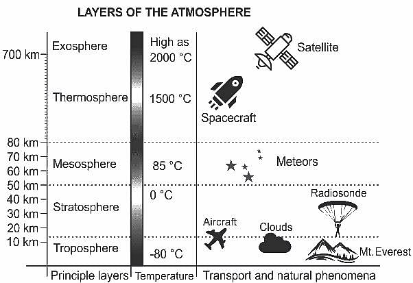
The atmosphere consists of different layers with varying densities and temperatures. The column of the atmosphere is divided into five different layers depending upon the temperature condition.
They are the troposphere, stratosphere, mesosphere, thermosphere, and exosphere.
The troposphere

  • It is the lowest part of the Earth's atmosphere in which all tropical changes take place. It contains about 75% of the total air in the atmosphere.
  • This layer contains dust particles and water vapor.
  • All changes in climate and weather take place in this layer.
  • This is the most important layer for all biological activity.
  • The zone separating the troposphere from the stratosphere is known as the tropopause.
  • The temperature here is nearly constant, and hence, it is called tropopause.

The stratosphere

  • It is found above the tropopause and extends up to a height of 50 km.
  • One important feature of the stratosphere is that it contains the ozone layer.
  • This layer absorbs ultraviolet radiation and shields life on the earth from an intense, harmful form of energy.
  • The stratopause caps the top of the stratosphere.

The mesosphere

  • It lies above the stratosphere, which extends up to a height of 80 km.
  • In this layer, once again, the temperature starts decreasing with the increase in altitude and reaches up to minus 100°C at a height of 80 km.
  • The upper limit of the mesosphere is known as mesopause.

The thermosphere 

  • It is located between 80 and 400 km above the mesopause.
  • It contains electrically charged particles known as ions, and hence, it is also known as the ionosphere.
  • Radio waves transmitted from the earth are reflected back to the earth by this layer.
  • It contains Ions and helps in wireless communication
  • The temperature here starts increasing with height.

The exosphere

  • It is the uppermost layer of the atmosphere.
  • This is the highest layer but very little is known about it.
  • Whatever contents are there, these are extremely rarefied in this layer, and it gradually merges with outer space.

Test: General Awareness (World Geography) - Question 4

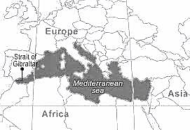
Which Strait divides Europe from Africa ?

Detailed Solution for Test: General Awareness (World Geography) - Question 4

The correct answer is Gibraltar.

Key Points

  • Strait of Gibraltar
    • The Strait of Gibraltar connects the Atlantic Ocean with the Mediterranean Sea and separates Spain on the European continent from Morocco on the African continent.

  • Hence option 3 is correct.

Additional Information

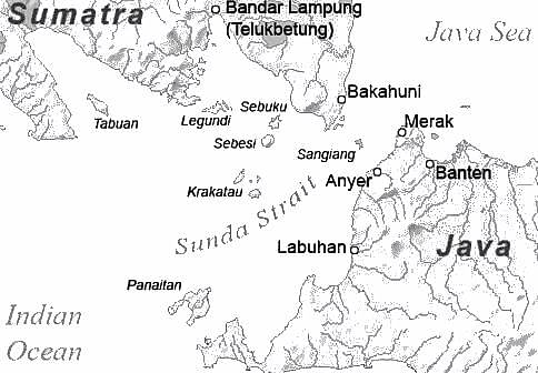
  • Sunda Strait
    • Sunda Strait, Indonesian Selat Sunda, is a channel, 16–70 miles (26–110 km) wide, between the islands of Java (east) and Sumatra.
    • The Sunda Strait is an important passage connecting the Indian Ocean with eastern Asia.

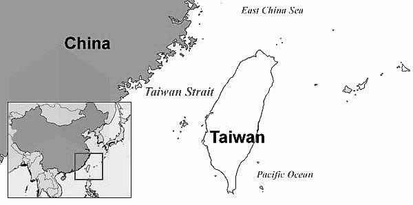
  • Taiwan Strait
    • The Taiwan Strait, also known as the Formosa Strait, is a 180-kilometre-wide strait separating the island of Taiwan and continental Asia.
    • The strait is currently part of the South China Sea and connects to the East China Sea to the north.
    • The narrowest part is 130 km wide.

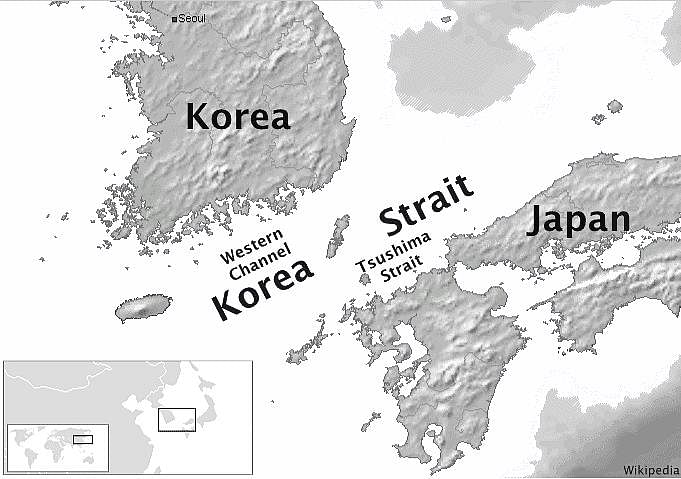
  • Tsushima Strait
    • Tsushima Strait or Eastern Channel is a channel of the Korea Strait, which lies between Korea and Japan, connecting the Sea of Japan, the Yellow Sea, and the East China Sea.

Test: General Awareness (World Geography) - Question 5
Which ocean is 'S' shaped?
Detailed Solution for Test: General Awareness (World Geography) - Question 5

The correct answer is the Atlantic ocean.

Key Points

Atlantic Ocean:

  • The ocean that forms the shape of the letter “S”, is the Atlantic ocean if it is looked closely on the world map.
  • The Arctic Ocean is connected/ linked through the  Barents Sea, Norwegian Sea, Greenland Sea, and the Denmark Strait.
  • The Puerto Rico Trench, which is about  28,230 feet deep, is the deepest point in the Atlantic Ocean.
  • It is also the busiest ocean in terms of Commerce and Trade


Additional Information

Pacific Ocean:

  • It is the largest and deepest ocean on Earth.
  • The Extension of this ocean is from the Arctic Ocean in the north to the Southern Ocean in the south.
  • This ocean is also bounded by the continents of Asia, Australia, and the Americas.
  • The Challenger Deep depth of 10,902 to 10,929 m, lies in the Mariana Trench, which is the deepest point in the world located in this ocean.

Mediterranean:

  • The sea was an important and famous route for merchants and travellers of ancient times.
  • It also facilitated trade and cultural exchange between peoples of the region and around the world.
  • The Strait of Gibraltar connects the Atlantic Ocean to the Mediterranean Sea and it also separates Spain in Europe from Morocco in Africa.

Indian Ocean:

  • It is the third-largest of the world's oceans on Earth's surface.
  • It is bounded by Asia, Africa and Australia to the north, west and east respectively.
  • The Southern Ocean or Antarctica bounds it to the south.
  • The Indian Ocean has some regional seas such as the Arabian Sea, Bay of Bengal, the Laccadive Sea, the Somali Sea, and the Andaman Sea.


Test: General Awareness (World Geography) - Question 6

The Blue Mountain Peak is located in the State of India - 

Detailed Solution for Test: General Awareness (World Geography) - Question 6

The correct answer is Mizoram.

Key Points

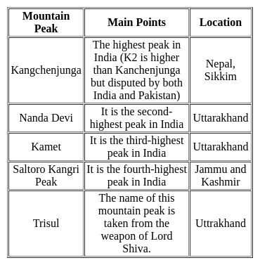
  • The Blue Mountain Peak is located in Mizoram.
  • Blue Mountain is also known as Phawngpui.
  • It is the highest mountain peak in the Mizo Hills.
  • Blue Mountain has an elevation of 2157 m.

Important Point
Highest Peaks in India​:

Test: General Awareness (World Geography) - Question 7

Which of the following neighbouring country of India shares its borders with maximum number of Indian states?

Detailed Solution for Test: General Awareness (World Geography) - Question 7

The correct answer is Nepal.

Key Points

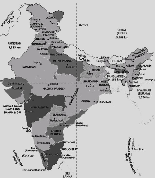
  • Nepal shares borders with 5 states viz; Uttarakhand, Uttar Pradesh, Bihar, West Bengal, Sikkim.​
    • India shares a borderline with Nepal of about 1752 Km.
  • China shares its borders with four Indian states.
    • ​They are Himachal Pradesh, Uttarakhand, Sikkim, and Arunachal Pradesh.
    • Ladakh is now a separate union territory and not a part of Jammu and Kashmir.
    • India shares 3488 Km of the border with China.
  • India shares its borders with three Indian states with Pakistan.
    • India shares a borderline with Pakistan of about 3310 Km.
    • They are Gujarat, Punjab, Rajasthan.
    • And Jammu Kashmir and Ladakh also share a border but it is a UT.
  • India shares its borders with four Indian states with Bhutan.
    • They are Sikkim, West Bengal, Arunachal Pradesh, and Assam.
  • Myanmar shares its borders with four Indian states.
    • They are Arunachal Pradesh, Nagaland, Manipur, and Mizoram.

Confusion Points

  • China and Pakistan share boundaries with a total of 5 (State + UT).
  • Here in the question, the union territories are not being considered.
    • China: Himachal Pradesh, Uttarakhand, Sikkim, and Arunachal Pradesh. (States)
      • ​Ladakh ​(Union Territory)
    • ​Pakistan: Gujarat, Punjab, Rajasthan. (State)
      • ​ Jammu Kashmir and Ladakh ​(Union Territory)

Important Point

  • Bangladesh is bordered by the Indian states of West Bengal, Assam, Meghalaya, Tripura and Mizoram.
    • India has the longest international boundary with Bangladesh as it shares a borderline of about 4096.7 Km.

Test: General Awareness (World Geography) - Question 8
Garo-Khasi range is located in which Indian state?
Detailed Solution for Test: General Awareness (World Geography) - Question 8

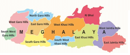
The correct answer is Meghalaya.

  • The Garo Khasi And Jayantia Hills were formed in the same age as of the Malwa Plateau.
  • The Garo, Khasi, And Jayantia Hills are located in Meghalaya.
  • The hills are named after the tribes found particularly in that region.
  • Meghalaya is also known as the Scotland of the East.


Test: General Awareness (World Geography) - Question 9

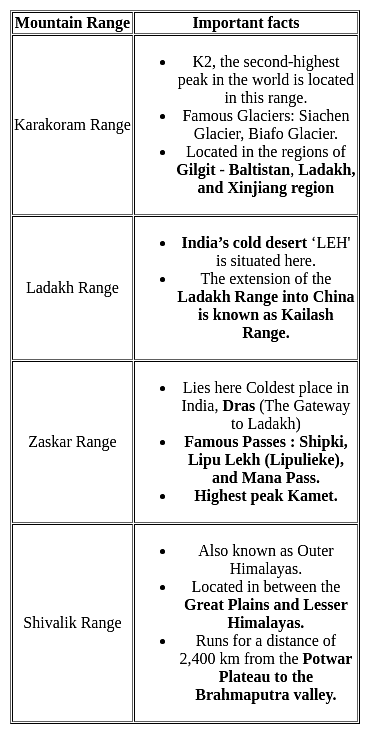
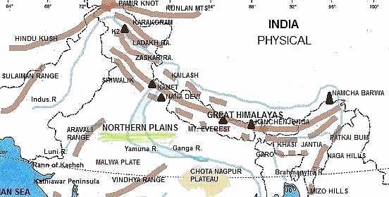
Which of the following options has the correct sequence of mountain ranges from North to South in India?

Detailed Solution for Test: General Awareness (World Geography) - Question 9

The correct answer is ​Karakoram, Ladakh, Zaskar, Shiwalik.

Test: General Awareness (World Geography) - Question 10

India is divided into how many earthquake zones (seismic zones)?

Detailed Solution for Test: General Awareness (World Geography) - Question 10

The correct answer is 4.

Important Points

  • Based on historical seismic activity, the Bureau of Indian Standards has categorized regions in India into four seismic zones: zones II, III, IV and V.
  • Of these, the most seismically active area is Zone V and the least active is Zone II. 
  • There is a history of devastating earthquakes on the Indian subcontinent.
  • The key cause for the high frequency and severity of earthquakes is that the Indian plate is driving into Asia at a rate of roughly 47 mm/year.
  • India's geological figures indicate that about 54 percent of the land is prone to earthquakes.
  • Research by the World Bank and the United Nations predicts that by 2050, about 200 million urban dwellers in India will be vulnerable to storms and earthquakes.
  • The most recent edition of India's seismic zoning map given in India's earthquake-resistant design code [IS 1893 (Part 1) 2002] assigns four degrees of seismicity in terms of zone factors for India.
  • In other words, unlike its previous edition, which consisted of five or six zones for the region, India's earthquake zoning map divides India into four seismic zones (Zone 2, 3, 4, and 5).
  • According to the new zoning map, the maximum degree of seismicity is predicted in Zone 5, while the lowest level of seismicity is correlated with Zone 2.

Revised earthquake hazard zone map of India

Information about Test: General Awareness (World Geography) Page
In this test you can find the Exam questions for Test: General Awareness (World Geography) solved & explained in the simplest way possible. Besides giving Questions and answers for Test: General Awareness (World Geography), EduRev gives you an ample number of Online tests for practice
Download as PDF