UGC NET Exam  >  UGC NET Tests  >  UGC NET Paper 2 Geography Mock Test - 1 - UGC NET MCQ

UGC NET Paper 2 Geography Mock Test - 1 - UGC NET MCQ


Test Description

30 Questions MCQ Test - UGC NET Paper 2 Geography Mock Test - 1

UGC NET Paper 2 Geography Mock Test - 1 for UGC NET 2024 is part of UGC NET preparation. The UGC NET Paper 2 Geography Mock Test - 1 questions and answers have been prepared according to the UGC NET exam syllabus.The UGC NET Paper 2 Geography Mock Test - 1 MCQs are made for UGC NET 2024 Exam. Find important definitions, questions, notes, meanings, examples, exercises, MCQs and online tests for UGC NET Paper 2 Geography Mock Test - 1 below.
Solutions of UGC NET Paper 2 Geography Mock Test - 1 questions in English are available as part of our course for UGC NET & UGC NET Paper 2 Geography Mock Test - 1 solutions in Hindi for UGC NET course. Download more important topics, notes, lectures and mock test series for UGC NET Exam by signing up for free. Attempt UGC NET Paper 2 Geography Mock Test - 1 | 100 questions in 120 minutes | Mock test for UGC NET preparation | Free important questions MCQ to study for UGC NET Exam | Download free PDF with solutions
UGC NET Paper 2 Geography Mock Test - 1 - Question 1

In India which age group is considered as economically productive?

Detailed Solution for UGC NET Paper 2 Geography Mock Test - 1 - Question 1

The age composition of a population refers to the number of people in different age groups in a country. The number and percentage of a population found within the children, working-age and aged groups are notable determinants of the population’s social and economic structure. The population of a nation is, generally, grouped into three broad categories.
Key-Points

Children (generally below 15 years)

  • They are considered an economically unproductive group.
  • The people need to be provided with food, clothing, education, and medical care.

Working Age (15–59 years)

  • This age group is considered economically productive and biologically reproductive.
  • They comprise the working population

Aged (Above 59 years)

  • People of this age group can be economically productive though they may have retired.
  • They may be working voluntarily but they are not available for employment through recruitment.

So, it is clear that the age group of 15 - 59 years is considered as economically productive in our country.

Hence, option 2 is the correct answer.

UGC NET Paper 2 Geography Mock Test - 1 - Question 2

Between 2010 and 2019, India's population grew at an average annual rate of:

Detailed Solution for UGC NET Paper 2 Geography Mock Test - 1 - Question 2

The correct answer is 1.2%.

  • Between 2010 and 2019, India's population grew at an average annual rate of 1.2%.

Key Points

  • The United Nations Population Fund released the State of World Population 2019 report.
  • India’s population grew at an average annual rate of 1.2 per cent between 2010 and 2019 to 1.36 billion.
  • It was more than double the annual growth rate of China.
  • India also recorded an improvement in life expectancy at birth.
    • The life expectancy at birth in 1969 was 47 years and in 2019, it is 69 years.
  •  According to the report, in India, the total fertility rate per woman was 5.6 in 1969, dropping to 3.7 in 1994 and 2.3 in 2019.
  • The UNFPA report highlights that untold millions have enjoyed healthier and more productive lives in the 50 years since the agency was founded.
1 Crore+ students have signed up on EduRev. Have you? Download the App
UGC NET Paper 2 Geography Mock Test - 1 - Question 3

According to the Radioactive Theory of Mountain Building, which of the following is not a factor that contributes to the formation of mountains?

Detailed Solution for UGC NET Paper 2 Geography Mock Test - 1 - Question 3

Key Point

Explanation of all the options:

  • (A) The decay of radioactive elements in the Earth's crust:

Radioactive elements in the Earth's crust decay over time, releasing heat. This heat causes the crust to expand, which can lead to the formation of mountains.

  • (B) The release of heat from radioactive decay:

The heat released from radioactive decay can cause the crust to expand, which can lead to the formation of mountains.

  • (C) The expansion of the Earth's crust:

The expansion of the Earth's crust can lead to the formation of mountains. This expansion can be caused by a number of factors, including the decay of radioactive elements and the movement of tectonic plates.

  • (D)The movement of tectonic plates:

The movement of tectonic plates is not a factor that contributes to the formation of mountains according to the Radioactive Theory of Mountain Building. However, the movement of tectonic plates is the main factor that contributes to the formation of mountains according to the Plate Tectonics Theory.

Additional Information

  •  The Radioactive Theory of Mountain Building was proposed by John Joly in 1925.
  • This theory states that the decay of radioactive elements in the Earth's crust releases heat, which causes the crust to expand. This expansion leads to the formation of mountains.
  • According to the Radioactive Theory of Mountain Building, the decay of radioactive elements in the Earth's crust, the release of heat from radioactive decay, and the expansion of the Earth's crust are all factors that can contribute to the formation of mountains.

Hence, the correct option will be 4) The movement of tectonic plates.

UGC NET Paper 2 Geography Mock Test - 1 - Question 4

Consider the following statements: 
A. Relict Mountain are formed by differential erosion because of differing solubility and erodibility of rocks in the region.
B. Converging boundary volcanism produces island arch like the Japanese arc
C. Alps, Andes, Appalachian and Ural are the examples of Block mountains.
D. GK Gilbert gave the Thermal Contraction Theory in 1890.

Which of the following are Incorrect? 

Detailed Solution for UGC NET Paper 2 Geography Mock Test - 1 - Question 4

Answer: 3) Only C and D.

Key Points

  • Statement C is incorrect because Alps, Andes, Appalachian, and Ural are not examples of block mountains. They are examples of fold mountains.
  • Statement D is incorrect because G.K. Gilbert gave the Glacial rebound theory in 1890, not the Thermal Contraction Theory.
  • Thermal Contraction Theory was given by H. Jeffreys in his famous book, The Earth: Its origin history and physical constitution.

Additional Information 

Relict mountains are mountains that have been worn down by erosion over time. They are typically rounded and have gentle slopes.

Converging boundary volcanism occurs when two tectonic plates collide, causing one plate to be forced beneath the other. This process can create island arcs, which are chains of volcanic islands.

Block mountains are formed when large blocks of the Earth's crust are uplifted or tilted by tectonic forces.

Thermal Contraction Theory states that the Earth's crust has contracted as the Earth has cooled, causing mountains to form.

Glacial rebound theory states that the Earth's crust has rebounded after the weight of glaciers has been removed, causing mountains to form.

UGC NET Paper 2 Geography Mock Test - 1 - Question 5

"These mountains are formed by vertical movements of blocks next to faults". The given statement is correct for which of the following:

Detailed Solution for UGC NET Paper 2 Geography Mock Test - 1 - Question 5

Answer: 2) Block mountains.

Key Points

  •  Block mountains are formed by the vertical movement of blocks of the Earth's crust along faults.
  • These faults are typically caused by the collision of two tectonic plates. When two plates collide, one plate is often forced beneath the other in a process called subduction.
  • As the subducting plate descends into the mantle, it melts and rises to the surface as magma. This magma can erupt onto the surface, forming volcanoes, or it can solidify beneath the surface, forming plutons.
  • The collision of the plates also causes the crust to fold and fault, which can create block mountains.
  • Block mountains are typically characterized by steep slopes, sharp crests, and flat tops. They are often found in groups, or ranges, and can be hundreds of kilometers long.
  • Some of the most famous block mountains in the world include the Sierra Nevada mountains in California, the Rocky Mountains in North America, and the Andes Mountains in South America.

Additional Information

  • Fold mountains are formed when two tectonic plates collide, causing the Earth's crust to fold and buckle. This type of mountain is typically long and narrow, with steep sides and a sharp crest.
  • Relict mountains are mountains that have been worn down by erosion over time. They are typically rounded and have gentle slopes.
  • Upwarped mountains are formed when a large area of the Earth's crust is uplifted, but the rocks are not folded or faulted. This type of mountain is typically broad and has a gently sloping top.
UGC NET Paper 2 Geography Mock Test - 1 - Question 6

The general term for periods of mountain-building that include folding, faulting, magmatism and metamorphism is called as:

Detailed Solution for UGC NET Paper 2 Geography Mock Test - 1 - Question 6

Answer: 3) Orogeny.

Key Points

  • Orogeny is a geological process that involves the formation and uplift of large, elevated landforms, known as mountains.
  • These landforms are typically characterized by steep slopes, high elevations, and rugged terrain. Orogeny occurs when two or more tectonic plates collide, causing one plate to be forced beneath the other in a process called subduction.
  • As the subducting plate descends into the mantle, it melts and rises to the surface as magma. This magma can erupt onto the surface, forming volcanoes, or it can solidify beneath the surface, forming plutons.
  • The collision of the plates also causes the crust to fold and fault, which can create mountains.

Additional Information

Rejuvenation: 

  • Rejuvenation is the process by which a river's erosional power is renewed, typically by a change in base level.
  • The base level is the height or altitude to which the river flows before it either joins another river or reaches the sea.
  • If base level falls, a step or 'kink' called a knick point is formed in the river's long profile.
  • Rejuvenation can lead to a number of changes in landscape, including the formation of waterfalls and rapids, knick points, river terraces, and incised meanders
  • Rejuvenated terrains usually have complex landscapes because remnants of older landforms are locally preserved.

Convergence

  • Convergence is the process by which two or more tectonic plates move towards each other.
  • When two plates converge, one plate is typically forced beneath the other in a process called subduction.
  • Subduction can cause a number of geological phenomena, including earthquakes, volcanoes, and mountain building.

Sedimentation

  • Sedimentation is the process by which sediment is deposited and accumulates.
  • Sediment is any material that is transported and deposited by wind, water, or ice.
  • Sedimentation can occur in a variety of environments, including rivers, lakes, oceans, and deserts.
UGC NET Paper 2 Geography Mock Test - 1 - Question 7

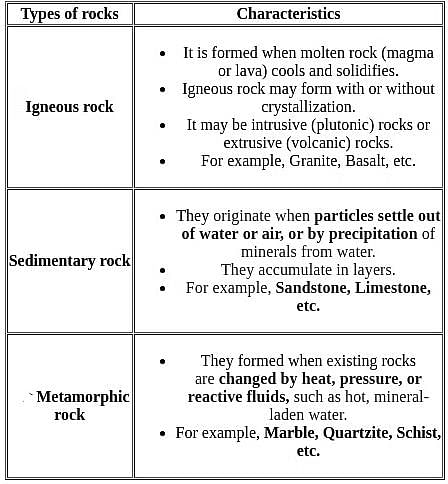
Which of the following is a metamorphic rock?

Detailed Solution for UGC NET Paper 2 Geography Mock Test - 1 - Question 7

The Correct is Gneiss.

 Key Points

  • Gneiss usually forms by regional metamorphism at convergent plate boundaries.
  • It is a high-grade metamorphic rock in which mineral grains recrystallized under intense heat and pressure

 Important Points

  • Basalt is a dark-colored, fine-grained, igneous rock composed mainly of plagioclase and pyroxene minerals.
  • Syenite is an intrusive igneous rock composed of feldspar and a ferromagnesian mineral.
  • Chemically, syenites contain a moderate amount of silica, relatively large amounts of alkalies, and alumina.
  • Sandstone is a sedimentary rock composed mostly of quartz sand.
  • Sandstone that contains more than 90% quartz is called quartzose sandstone.
  • When the sandstone contains more than 25% feldspar, it is called arkose or arkosic sandstone.

Additional Information


UGC NET Paper 2 Geography Mock Test - 1 - Question 8
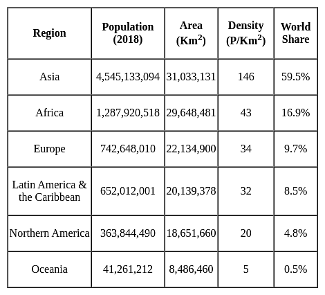
Which of the following Regions has the highest population density?
Detailed Solution for UGC NET Paper 2 Geography Mock Test - 1 - Question 8
UGC NET Paper 2 Geography Mock Test - 1 - Question 9
Which of the following statement is correct in the case of weathering?
Detailed Solution for UGC NET Paper 2 Geography Mock Test - 1 - Question 9

All of the above sentences are correct. Talus and scree are like the by-products of granular disintegration which occur because of the insolation process and these are created because of insolation as well as the different mineral composition of rocks. Erosion, as the term indicates is the removal or transportation of weathered rock material from one place to another. Hence it is a dynamic process unlike weathering. However, Mechanical weathering involves the disintegration and breaking of rocks by frost action, freeze and thaw and pressure release.

UGC NET Paper 2 Geography Mock Test - 1 - Question 10
The Gulf Stream drift westwards in 400 North latitude due to
Detailed Solution for UGC NET Paper 2 Geography Mock Test - 1 - Question 10

The zonal westerly winds are also called prevailing winds or anti-trade winds. They flow from west to east direction in 30-60 degrees latitude. The zonal westerly winds in the northern hemisphere cause the warm Gulf Stream to drift westwards, where it is called as North Atlantic Drift.

Thus, the correct answer is A.

UGC NET Paper 2 Geography Mock Test - 1 - Question 11

Polavaram Project is located in which state?

Detailed Solution for UGC NET Paper 2 Geography Mock Test - 1 - Question 11

Andhra Pradesh of Godavari Waters to Krishna Basin. The Project is located in Andhra Pradesh near Polavaram village about 34 KMs.

Thus, the correct answer is C.

UGC NET Paper 2 Geography Mock Test - 1 - Question 12
Given below are two statements. One is labelled as Assertion (A) and the other is labelled as Reason (R):

Assertion (A): Investment in SOC increases investment in Direct Productive Activities, providing cheap energy and power supply.

Reason (R) : Albert Hirschmann suggests investment in Social Overhead Capital(SOC).

Select the correct answer from options given below:

Detailed Solution for UGC NET Paper 2 Geography Mock Test - 1 - Question 12

In his Theory of Unbalanced Growth Albert O. Hirschmann explains that profits and losses are symptoms of disequilibrium or imbalances in economy. He suggests that investment should be made in Social Overhead Capital (SOC) to create these imbalances. It has activities that support primary, secondary activities like education, transport and communication, drainage, etc. Investment in these leads to encouragement for investment in Direct Productive Activities (DPA). This provides cheap facilities for industries and agriculture like electricity and power supply.

Thus, the correct answer is A.

UGC NET Paper 2 Geography Mock Test - 1 - Question 13

Consider the following statements-

1. These winds blow from the subtropical high-pressure belts towards the sub-polar low-pressure belts.

2. They are stronger in the southern hemisphere. 

3. These winds are best developed between 40° and 65°S latitudes.

Statements given-above are about which planetary wind?

Detailed Solution for UGC NET Paper 2 Geography Mock Test - 1 - Question 13

The correct answer is Westerlies.

Key Points

  •  Westerlies:
    • The westerlies are the winds blowing from the subtropical high-pressure belts towards the subpolar low-pressure belts.
    • They blow from south­west to north-east in the northern hemisphere and north-west to south-east in the southern hemisphere.
    • The westerlies of the southern hemisphere are stronger and persistent due to the vast expanse of water, while those of the northern hemisphere are irregular because of uneven relief of vast land-masses.
    • The westerlies are best developed between 40° and 65°S latitudes.

Additional Information

  • Primary Winds or Prevailing Winds or Permanent Winds or Planetary Winds
    • These are the planetary winds which blow extensively over continents and oceans.
    • The two most well-understood and significant winds for climate and human activities are trade winds and westerly winds.
  • Trade Winds:
    • The trade winds are those blowing from the sub-tropical high-pressure areas towards the equatorial low-pressure belt
    • Therefore, these are confined to a region between 30°N and 30°S throughout the earth’s surface.
    • They flow as the north-eastern trades in the northern hemisphere and the south-eastern trades in the southern hemisphere.
    • Trade winds are descending and stable in areas of their origin (sub-tropical high-pressure belt), and as they reach the equator, they become humid and warmer after picking up moisture on their way.
    • The trade winds from two hemispheres meet at the equator, and due to convergence they rise and cause heavy rainfall.
  • Polar easterlies:
    • The Polar easterlies are dry, cold prevailing winds blowing from north-east to south-west direction in Northern Hemisphere and south-east to the north-west in Southern Hemisphere.
    • They blow from the polar high-pressure areas of the sub-polar lows
UGC NET Paper 2 Geography Mock Test - 1 - Question 14

Which of the following waves is used in the process of remote sensing?

Detailed Solution for UGC NET Paper 2 Geography Mock Test - 1 - Question 14

The waves used in common TV remote control are Infrared Rays.

  • Infrared (IR), sometimes called infrared light, is electromagnetic radiation (EMR) with wavelengths longer than those of visible light. 
  • Infrared Rays are Electromagnetic waves.
  • It is therefore invisible to the human eye.
  • IR is generally understood to encompass wavelengths from the nominal red edge of the visible spectrum around 700 nanometers (frequency 430 THz) to 1 millimeter (300 GHz) (although the longer IR wavelengths are often designated rather as terahertz radiation).
  • Black-Body Radiation from objects near room temperature is almost all at infrared wavelengths.
  • As a form of electromagnetic radiation, IR propagates energy and momentum, with properties corresponding to both those of a wave and of a particle, the photon

Additional Information

  •  An X-ray, or X-radiation, is a penetrating form of high-energy electromagnetic radiation. Most X-rays have a wavelength ranging from 10 picometers to 10 nanometers, corresponding to frequencies in the range 30 petahertz to 30 exahertz and energies in the range 124 eV to 124 keV.
  • Ultraviolet (UV) is a form of electromagnetic radiation with a wavelength from 10 (with a corresponding frequency around 30 PHz) to 400 nm (750 THz), shorter than that of visible light, but longer than X-rays. UV radiation is present in sunlight and constitutes about 10% of the total electromagnetic radiation output from the Sun. It is also produced by electric arcs and specialized lights, such as mercury-vapour lamps, tanning lamps, and black lights.
  • A Gamma-ray, or gamma radiation, is a penetrating form of electromagnetic radiation arising from the radioactive decay of atomic nuclei. It consists of the shortest wavelength electromagnetic waves and so imparts the highest photon energy.
UGC NET Paper 2 Geography Mock Test - 1 - Question 15
Which of the following is a ‘barrier’ on foreign trade?
Detailed Solution for UGC NET Paper 2 Geography Mock Test - 1 - Question 15
Key Points

Barriers to foreign trade:

  • Tax on imports is an example of a trade barrier.
  • It is called a barrier because some restriction has been set up.
  • Governments can use trade barriers to increase or decrease (regulate) foreign trade and to decide what kinds of goods and how much of each, should come into the country.
  • The three major barriers to international trade are natural barriers, such as distance and language; tariff barriers, or taxes on imported goods; and non-tariff barriers.
  • The non-tariff barriers to trade include import quotas, embargoes, buy-national regulations, and exchange controls.

Hence, the tax on imports is a ‘barrier’ to foreign trade.

Additional Information

  • Production cost: Production costs refer to the costs a company incurs from manufacturing a product or providing a service that generates revenue for the company.
  • Market price: The term market price refers to the amount of money for which an asset can be sold in a market.
  • Goods and services: Production of goods and providing services are economic activities, they are not barriers of trade
UGC NET Paper 2 Geography Mock Test - 1 - Question 16
Which among the following is a true statement?
Detailed Solution for UGC NET Paper 2 Geography Mock Test - 1 - Question 16

The true statement among the given options is: Inner planets are made up of rocks. Important PointsInner planets, also known as terrestrial planets, are composed mainly of rocks and metals.

  • These planets are located closer to the Sun compared to the outer planets.
  • The inner planets in our solar system are Mercury, Venus, Earth, and Mars. They have solid surfaces and are primarily composed of materials such as silicates, iron, and other rocky substances.

On the other hand, the outer planets, also known as gas giants or giant planets, are primarily composed of gases like hydrogen and helium.

  • They are much larger in size compared to the inner planets. The outer planets in our solar system are Jupiter, Saturn, Uranus, and Neptune.

Therefore, the statement "Inner planets are made up of rocks" is true.

UGC NET Paper 2 Geography Mock Test - 1 - Question 17

Read the following statements about sustainable development.

Statement (A): Sustainable development is a process of maximum exploitation of resources.

Statement (B): In absence of sustainable development non-renewable resources can definitely get exhauste.

Choose the correct option.

Detailed Solution for UGC NET Paper 2 Geography Mock Test - 1 - Question 17

The correct option is: (A) is false, but (B) is true.
Important Points

Statement (A) states that sustainable development is a process of maximum exploitation of resources.

  • This statement is false.
  • Sustainable development aims to balance economic, social, and environmental considerations to meet the needs of the present generation without compromising the ability of future generations to meet their own needs.
  • It emphasizes the responsible and efficient use of resources rather than maximum exploitation.

Statement (B) states that in the absence of sustainable development, non-renewable resources can definitely get exhausted.

  • This statement is true.
  • Non-renewable resources such as fossil fuels (coal, oil, natural gas) and minerals are finite in quantity and take millions of years to form.
  • If these resources are not managed sustainably, they can be depleted faster than they can be replenished, leading to their exhaustion.

Therefore, (A) is false as sustainable development does not involve maximum exploitation of resources, and (B) is true as non-renewable resources can indeed get exhausted in the absence of sustainable development.

UGC NET Paper 2 Geography Mock Test - 1 - Question 18
Which of the following are cruciform settlements?
Detailed Solution for UGC NET Paper 2 Geography Mock Test - 1 - Question 18

The correct answer is 1 and 2 Both options.

Key Points

Cruciform settlements

  • T-shaped and Y-shaped both are Cross-shaped or cruciform settlements.
  • T -shaped settlements develop at tri-junctions of the roads.
  • While Y-shaped settlements emerge as the places where two roads converge on the third one and houses are built along these roads.
  • Cruciform settlements develop on the cross-roads and houses extend in

​Y-shaped settlement

All the rural settlements:

UGC NET Paper 2 Geography Mock Test - 1 - Question 19
Rain shadow effect is associated with
Detailed Solution for UGC NET Paper 2 Geography Mock Test - 1 - Question 19

The correct option is 2 i.e. Orographic rainfall.

  • Rainshadow effect is associated with mountains and this kind of rainfall involving geological structures are known as Orographic rainfalls.
  • Orographic rain is formed wherever moist air is forced to ascend a mountain barriers it is best developed on the windward slope.
  • It is also known as relief rain.
  • The leeward side gets less precipitation and hence remain dry. Ex- Vidarbha region of Maharashtra which is on the leeward side of Western Ghats.
  • Cyclonic rainfall is associated with cyclonic activity in temperate regions or in tropical regions. It is caused due to the convergence of two different air masses with different temperatures.
  • It is also known as frontal rain.
  • Conventional rain is caused by convection currents.
  • When the earth's surface is heated by conduction moisture-laden vapours rises because of heated air expands and becomes lighter this vapour condenses into cumulonimbus clouds. It is mostly associated with cumulonimbus clouds and thunderstorms.
UGC NET Paper 2 Geography Mock Test - 1 - Question 20

Consider the following statements about Human settlements

1. Conurbation refers to rarely dense rural settlements which are also known as cross-shaped settlements.

2. Conurbations are part of metropolisation which is a process related to the unprecedented physical growth of cities in the fringe areas.

Which of the statements given above is/are correct?

Detailed Solution for UGC NET Paper 2 Geography Mock Test - 1 - Question 20

The correct answer is 2 only.

Key Points

  • The term conurbation was coined by Patrick Geddes in 1915.
  • Conurbation referred to a large area of urban development that resulted from the merging of originally separate towns or cities. Greater London, Manchester, Chicago and Tokyo are examples. Hence statement 1 is incorrect.
  • Conurbations are part of metropolisation which is a process related to the unprecedented physical growth of the city in the fringe areas. Hence, statement 2 is correct.
  • T-shaped, Y-shaped, Cross-shaped or cruciform settlements: T -shaped settlements develop at tri-junctions of the roads while -shaped settlements emerge as the places where two roads converge on the third one and houses are built along these roads.

Additional Information

Types of Urban Settlement-

  • Town
    • The concept of ‘town’ can best be understood with reference to ‘village’. Population size is not the only criterion.
  • City
    • In the words of Lewis Mumford, “ the city is in fact the physical form of the highest and most complex type of associative life”.
  • Conurbation
    • It refers to a large area of urban development that resulted from the merging of originally separate towns or cities. Greater London, Manchester, Chicago and Tokyo are examples.
  • Megalopolis
    • It refers to the union of conurbations.
UGC NET Paper 2 Geography Mock Test - 1 - Question 21

Bundestag' and 'Bundesrat are the two Houses of Legislature in

Detailed Solution for UGC NET Paper 2 Geography Mock Test - 1 - Question 21

The correct answer is Germany.

  • Bundestag and Bundesrat are the two Houses of Legislature in Germany.

Key Points

  • The German Bundesrat is the constitutional body through which the states participate in the legislative process.
  • Elections for the Bundestag take place every four years.
  • Seats are allocated according to a personalized proportional voting system that combines a personal vote for a particular candidate in a district (first vote) with a party vote (second vote).

Additional Information

  • Features we took from Germany
    • Fundamental Rights are suspended during Emergency.
UGC NET Paper 2 Geography Mock Test - 1 - Question 22
What BEST describes the impact of technology on the tourism industry?
Detailed Solution for UGC NET Paper 2 Geography Mock Test - 1 - Question 22

Answer: 3) It offers both opportunities for personalized experiences and privacy concerns.

The profound impact of technology on the tourism industry cannot be overstated. It has revolutionized how services are delivered, enhanced the customer experience, and also introduced new challenges. Among these impacts, the ability to offer personalized travel experiences alongside emerging privacy concerns stands out as especially significant.
Key Points
It offers both opportunities for personalized experiences and privacy concerns:
  • Advanced data analytics and AI enable travel companies to tailor their offerings to individual preferences, improving customer satisfaction and engagement.
  • From personalized travel recommendations to targeted marketing, technology makes it possible to cater to the unique desires of each traveler.
  • However, this customization relies on collecting and analyzing vast amounts of personal data, raising legitimate concerns about privacy and data protection.
  • As companies navigate these opportunities, they must also address the ethical considerations and regulatory requirements associated with handling personal information.
Additional Information
INCOREECT OPTIONS:
It primarily leads to job losses in the travel industry:
  • While technology has automated certain functions that previously required manual effort, suggesting that it primarily leads to job losses oversimplifies its impact.
  • Technology also creates new opportunities and jobs within the industry, such as in digital marketing, data analysis, and IT support.
  • Furthermore, by improving efficiency and customer experiences, technology can drive growth and demand, potentially leading to job creation in other areas of the tourism sector.
It solely benefits large travel companies and booking platforms:
  • Although large travel companies and booking platforms have indeed benefited from technological advancements, they are not the sole beneficiaries.
  • Technology has also empowered smaller operators by leveling the playing field, enabling them to reach a global audience through social media, online marketplaces, and affordable travel technologies.
  • Startups and innovative enterprises can disrupt the market with new ideas and services, indicating that the benefits of technology in tourism are more widely distributed.
It has minimal impact on travel planning and booking processes:
  • This statement underestimates the dramatic transformation technology has brought to planning and booking travel.
  • Online booking platforms, mobile apps, virtual reality previews, and user-generated content on social media have all made researching and booking travel more accessible, convenient, and informative for consumers.
  • The shift towards online and mobile channels has fundamentally changed how travelers interact with the industry, making technology's impact far from minimal.
Important Points
  • The intersection of technology and tourism continues to evolve, offering immense potential to enhance the travel experience while posing new challenges.
  • As the industry adapts to these changes, the focus should remain on harnessing technology to improve services and operational efficiency, while also prioritizing ethical considerations and customer trust, particularly concerning privacy.
UGC NET Paper 2 Geography Mock Test - 1 - Question 23
Who postulated the paving stone hypothesis?
Detailed Solution for UGC NET Paper 2 Geography Mock Test - 1 - Question 23

The term plate was first used by J.T. Wilson in 1965. McKenzie and Parker elaborated the mechanism behind the movement of plates in 1967. It was based on Euler’s geometrical theorem. Based on this, they gave the paving stone hypothesis. It says that oceanic crust is formed at the ridges and destroyed at the trenches. Isacks and Sykes confirmed this hypothesis in 1967.

Thus, the Correct answer is B.

UGC NET Paper 2 Geography Mock Test - 1 - Question 24
Die Erdkunde was written by
Detailed Solution for UGC NET Paper 2 Geography Mock Test - 1 - Question 24

‘Die Erdkunde’ means Earth sciences. It is often used as translation of geography in German language. It is a collection of 19 volumes of books with over 20000 pages. It was written by Carl Ritter. It was intended to be complete geography of the world, but Ritter could complete only Asia and Africa in his lifetime.

Thus, the correct answer is C.

UGC NET Paper 2 Geography Mock Test - 1 - Question 25
Consider the following statements:-

a) Potholes and Plunge pools are found in the upper course of the river.

b) During the formation of meanders, the river does the erosional work on the convex bank and the depositional work on the concave bank.

c) A large number of tributaries joining the main river also lead to the formation of Deltas.

d) Braided stream is that which gets divided into several networks due to excess deposits on the river plain.

Which of the following statements are correct?

Detailed Solution for UGC NET Paper 2 Geography Mock Test - 1 - Question 25

A river follows a curved path. As a result, the speed of the river water slows down and the river does both the works of erosion and deposition. However, when the river starts to bend and swing in large curves, it does the erosional work on the concave bank of the river while deposition is done on the convex bank. This happens because the speed of the river water is more on the concave bank and less on the convex bank. This thing gradually increases and forms an S shape.

A large number of tributaries joining the main river are required for the formation of deltas as large amount of additional sediments are necessary. The more the number of steams, the more will the deposition of sediments which will consequently lead to delta formation.

UGC NET Paper 2 Geography Mock Test - 1 - Question 26
Which of the following is NOT an agent of weathering?
Detailed Solution for UGC NET Paper 2 Geography Mock Test - 1 - Question 26

When minerals in the rocks mix with the oxygen present in the water, oxides like iron oxide are formed, which weaken the rocks, causing weathering. Minerals in rock react to the presence of carbonate or bicarbonate, producing carbonic acid. This also leads to weathering. Frost cation weaken the rocks leading to block disintegration. Soil is formed due to weathering of rocks, but it is not an agent of weathering.

UGC NET Paper 2 Geography Mock Test - 1 - Question 27
Consider the following statements about Dualism:

i. Dualism means difference in views.

ii. Dualism lies in methodology.

iii. It includes content of study, approach of study and method of study.

Choose the correct option from below:

Detailed Solution for UGC NET Paper 2 Geography Mock Test - 1 - Question 27

Dualism means difference in views, in geography dualism lies in its methodology which includes content of study, approach of study and method of study. Content is the subject matter, approach is the point of view to look at a problem, method is the way to deal with the problem.

UGC NET Paper 2 Geography Mock Test - 1 - Question 28
Consider the following statements:-

a) Close to the equator, tropical cyclones do not occur because of excessive humidity.

b) The largest number of temperate cyclones originate mostly over the North Atlantic Ocean.

c) The central low-pressure core of a tropical cyclone is called depression.

d) The Polar frontal theory or the wave theory provides an adequate explanation of the origin of extra tropical cyclones.

Which of the following statements are correct?

Detailed Solution for UGC NET Paper 2 Geography Mock Test - 1 - Question 28

In the North Atlantic region high frequencies of tropical cyclones are found in the months of August, September and October. The period from December to May is free from cyclones. In the south western North Pacific greatest frequency is seen from July to October. There are no cyclones in the South Atlantic and the reason behind the absence of the tropical cyclones is that the intertropical convergence zone remains to the north of the equator so that no weak tropical disturbance develops over this ocean. Moreover, the sea surface temperature is comparatively low in the low latitudes.

UGC NET Paper 2 Geography Mock Test - 1 - Question 29

Name the currency of Japan

Detailed Solution for UGC NET Paper 2 Geography Mock Test - 1 - Question 29

The yen is the official currency of Japan. It is the third most traded currency in the foreign exchange market after the United States dollar and the euro.

UGC NET Paper 2 Geography Mock Test - 1 - Question 30

1. Assam shares a border with Bhutan and Bangladesh.

2. West Bengal shares a border with Bhutan and Nepal.

3. Mizoram shares a border with Bangladesh and Myanmar. Which of the statements given above are correct?

Detailed Solution for UGC NET Paper 2 Geography Mock Test - 1 - Question 30

All the statements given above are correct. Assam shares a border with Bhutan and Bangladesh, West Bengal shares a border with Bhutan and Nepal and Mizoram shares a border with Bangladesh and Myanmar.

View more questions
Information about UGC NET Paper 2 Geography Mock Test - 1 Page
In this test you can find the Exam questions for UGC NET Paper 2 Geography Mock Test - 1 solved & explained in the simplest way possible. Besides giving Questions and answers for UGC NET Paper 2 Geography Mock Test - 1, EduRev gives you an ample number of Online tests for practice

Top Courses for UGC NET

Download as PDF

Top Courses for UGC NET