UGC NET Exam  >  UGC NET Test  >   Mock Test Series 2026  >  UGC NET Paper 2 Geography Mock Test - 5 - UGC NET MCQ

UGC NET Paper 2 Geography Mock Test - 5 Free Online Test 2026


Full Mock Test & Solutions: UGC NET Paper 2 Geography Mock Test - 5 (100 Questions)

You can boost your UGC NET 2026 exam preparation with this UGC NET Paper 2 Geography Mock Test - 5 (available with detailed solutions).. This mock test has been designed with the analysis of important topics, recent trends of the exam, and previous year questions of the last 3-years. All the questions have been designed to mirror the official pattern of UGC NET 2026 exam, helping you build speed, accuracy as per the actual exam.

Mock Test Highlights:

  • - Format: Multiple Choice Questions (MCQ)
  • - Duration: 120 minutes
  • - Total Questions: 100
  • - Analysis: Detailed Solutions & Performance Insights

Sign up on EduRev for free and get access to these mock tests, get your All India Rank, and identify your weak areas to improve your marks & rank in the actual exam.

UGC NET Paper 2 Geography Mock Test - 5 - Question 1

Given below are two statements, one labeled as Assertion (A) and the other labeled as Reason (R):

Assertion (A): Pragmatism is a modified form of functionalism

Reason (R): Applied geography recognizes geographical space as a combination of knowledge and error.

In the context of the above two statements, which of the following is correct?

Detailed Solution: Question 1

The correct answer is (A) is wrong, but (R) is correct.
Key PointsAssertion (A): Pragmatism is a modified form of functionalism

  • Pragmatism and functionalism are two philosophies William James used to further his understanding of the world around him. James posited the pragmatic theory of truth and used.
  • This philosophy to define and re-define ideas, filtering answers to his questions through this theory. Most of his findings, theories, and inquiries were viewed according to his pragmatic theory of truth.
  • William James founded the school of functionalism. This school of thought in psychology was developed in direct response to the school of structuralism and the work of Wilhelm Wundt. Wundt criticized functionalism as nothing more than literature, and James criticized structuralism as “all school and no thought.”

Hence, Assertation is Incorrect

Reason (R): Applied geography recognizes geographical space as a combination of knowledge and error.

The elements of pragmatic geography can be identified as under: (i) Geographic space is a composite of knowledge and error. (ii) Geographic space is changeable as our knowledge of it changes and the scale of measurement becomes more refined.

Hence, The reason is correct

UGC NET Paper 2 Geography Mock Test - 5 - Question 2

Which of the following are evidences of Continent Drift Theory?

Detailed Solution: Question 2

The correct answer is All of the Above.

Key Points

Evidence that supports the theory:

  • The Matching of Continents (Jig-Saw-Fit):
    • The shorelines of Africa and South America facing each other match remarkably.
  • Rocks of Same Age Across the Oceans:
    • Radiometric dating methods have correlated the rock formation in different continents.
  • Tillite: 
    • The glacial tillite found in the Gondwana system of sediments has its resemblance to six different landmasses of the Southern Hemisphere.
  • Placer Deposits:
    • The placer deposits of gold in the Ghana coast do not have source rock in the region.
    • The gold deposits of Ghana have been derived from the Brazil plateau when the two continents lay side by side
  • Distribution of Fossils:
    • Identical species of plants and animals adapted to living on land or in freshwater are found on either side of the marine barriers.

Important Points

Continental Drift Theory:

  • Alfred Wegener put forward a continental drift theory in 1912.
  • All the continents are formed of a single Continental mass and a mega ocean surrounded the same.
  • The supercontinent was named Pangaea and the Mega Ocean was called Panthalassa.
  • Pangea first broke into two large Continental masses Laurasia and Gondwanaland Forming the northern and Southern components respectively.
  • Laurasia and Gondwanaland continued to break into smaller continents that existed today. ​

UGC NET Paper 2 Geography Mock Test - 5 - Question 3

Rimland theory was presented by M. J. Spykman in

Detailed Solution: Question 3

Rimland theory 

  • Nicholas John Spykman (1893 - 1943), an American political scientist propounded Rimland's theory in 1942.
  • It was published in 1944 in his book entitled The Geography of Peace

Hence, option 2 is the correct answer.

Main concept:

  • It is basically the opposite of the Heartland theory by Mackinder
  • The inner crescent of the Heartland theory is considered as the Rimland here
  • Topography, terrain, and climate are considered an important determinant of foreign policy
  • Peace is possible by collective security arrangement or international balance of power arrangement
  • Unified Rimland: strong land power the USA and the Soviet Union
  • He gave more emphasis on sea power
  • Seapower possible to conceive of the Eurasian continent as a unit
  • Defines the relationship between the old and new world
  • These regions have more potential than the Heartland
  • It is an intermediate region between Heartland and marginal sea region

The rimland:

The inner marginal crescent was divided into three parts in Rimland theory

  1. European land
  2. The Arabian middle eastern desert
  3. Asiatic monsoon land

Premises:

  • Who controls the Rimland rules Eurasia
  • Who rules Eurasia controls the destinies of the world

UGC NET Paper 2 Geography Mock Test - 5 - Question 4

Given below are two statements. One is labelled as Assertion (A) and the other is labelled as Reason (R).

Assertion (A): World Trade Organization has taken steps to fight climate change.

Reason (R) : The lack of clean technology in underdeveloped nations is a major hindrance in fight against climate change.

Select the correct answer from options given below:

Detailed Solution: Question 4

The underdeveloped and developing countries lack resources and technology for sustainable development. Thus, they prove to be a major block in fighting climate change. The World Trade Organization has taken steps like formulation of Sustainable Development Goals under United Nations Development Program in collaboration with United Nations. Thus, both (A) and (R) are true, but (R) is not the correct explanation of (A).

Thus, the correct answer is B.

UGC NET Paper 2 Geography Mock Test - 5 - Question 5

The heights of any place on the land are measured from,

Detailed Solution: Question 5

The correct answer is mean sea level.

Key Points

  • The heights of any place on the land are measured from mean sea level.
  • This is because sea is a continuous water body and its surface tends to seek the same level throughout the world.
  • Mean sea level is an average surface level of one or more among Earth's coastal bodies of water from which heights such as elevation may be measured.
  • A common mean sea level standard is the midpoint between a mean low and mean high tide at a particular location.

Thus, we can say that the heights of any place on the land are measured from the mean sea level.

Additional Information

  • A plain is a broad area of relatively flat land.
  • A slope is the rise or fall of the land surface.

UGC NET Paper 2 Geography Mock Test - 5 - Question 6

Which of the following is NOT one of the three chief movements of ocean waters?

Detailed Solution: Question 6

The correct answer is Water Current.Key Points

  • The 3 chief movements of ocean water are:
    • the waves,
    • the tides, and
    • the ocean currents.
  • Hence Water Current is NOT one of the three chief movements of ocean waters.
  • Oceans are a major part of the Hydrosphere.
  • They are all interconnected. The ocean waters are always moving.
  • The five major oceans are the Pacific Ocean, the Atlantic Ocean, the Indian Ocean, the Southern Ocean, and the Arctic Ocean, in order of their size.

Additional Information

  • Ocean currents are the constant, predictable, directional movement of seawater driven by gravity, wind (the Coriolis effect), and the density of the water.
  • Ocean water moves in two directions: horizontally and vertically. 
  • Horizontal movements are referred to as currents, while vertical changes are referred to as upwellings or downwellings.
  • Ocean currents are one of the factors that affect the temperature of ocean water.
    • Warm ocean currents raise the temperature in cold areas.
    • Cold ocean currents decrease the temperature in warmer areas.

UGC NET Paper 2 Geography Mock Test - 5 - Question 7

Which of the following statements about inversion of temperature is/are correct?

1. Temperature increases with increasing altitude.

2. A long winter night with clear skies is an ideal situation.

3. It is a short term phenomenon and is common all over the globe except at the poles.

Select the correct answer using the code given below :

Detailed Solution: Question 7

The correct answer is 1 and 2 only.

Key Points

Inversion of temperature:

  • Under normal conditions, temperature usually decreases with increase in altitude in the troposphere at a rate of 1 degree for every 165 metres. This is called normal lapse rate.
  • But on some occasions, the situations get reversed and the temperature starts increasing with height rather than decreasing. This is called temperature inversion. Hence, statement 1 is correct.
  • It is a reversal of the normal behavior of temperature in the troposphere. Under this meteorological phenomenon a layer of warm air lies over the cold air layer.
  • It is caused in stac atmospheric conditions while some times, it occurs due to horizontal or vertical movement of air.
  • Temperature inversion is usually of short duration but quite common nonetheless.

​​​Favourable Conditions for Temperature Inversion:

  • Long winter nights
    • Loss of heat by terrestrial radiation from the ground surface during night may exceed the amount of incoming solar radiation.
  • Cloudless and clear sky.
    • Loss of heat through terrestrial radiation proceeds more rapidly without any obstruction. Hence, statement 2 is correct.
  • Dry air near the ground surface
  • Slow movement of air
  • Snow covered ground surface
    • It results in maximum loss of heat through reflection of incoming solar radiation.
    • This regular temperature inversion in the high Arctic is caused by the lack of surface heating by the Sun, which stays below the horizon during the winter (the Polar Night), and the continuous loss of heat from the surface (through emission of infrared radiation).
    • Hence, temperature inversion is common phenomenon at the poles. Hence, statement 3 is not correct.

UGC NET Paper 2 Geography Mock Test - 5 - Question 8

At what plate boundary setting is the ocean floor deepest?

Detailed Solution: Question 8

Answer: Option 2) Subduction.

The Earth's lithosphere is divided into tectonic plates that interact with one another at plate boundaries, influencing the topography of the ocean floor. The subsequent question delves into the characteristics of different plate boundary settings and seeks to identify the setting where the ocean floor is the deepest.

Key Points

  • The ocean floor is deepest at subduction zones.
  • Subduction zones occur at convergent plate boundaries, where one tectonic plate is forced beneath another.
  • This process results in the formation of deep ocean trenches, such as the Mariana Trench in the western Pacific, which is known as the deepest point on Earth's ocean floor.
  • The subduction of oceanic plates beneath continental plates or another oceanic plate creates a trench-like depression.

 Additional Information

  • Divergent: At divergent plate boundaries, tectonic plates move away from each other, creating mid-ocean ridges. While these ridges can be elevated, they are not associated with the deepest parts of the ocean floor.
  • Continent - Continent Collision: Continent-continent collisions result in the formation of large mountain ranges, such as the Himalayas. While this setting can lead to significant topographical features, it does not create the deepest parts of the ocean floor.
  • Transform: Transform plate boundaries involve plates sliding past each other horizontally. They are associated with features like strike-slip faults but do not typically result in the creation of deep ocean trenches.

Hence, the ocean floor is deepest at subduction zones.

UGC NET Paper 2 Geography Mock Test - 5 - Question 9

What is the shallow submerged extension of a continent called?

Detailed Solution: Question 9

Answer: Option 3) continental Shelf.

The Earth's surface exhibits a fascinating interplay between land and water, and one notable feature is the transition between continents and oceans. Unlike a clear and defined separation, continents gradually slope seaward from the coast. This slope leads to the formation of a shallow submerged extension of the continent, a geographical feature of great importance. The upcoming question explores the terminology associated with this submerged extension.

Key Points

  • The shallow submerged extension of a continent is termed the Continental Shelf.
  • This region, varying in width and depth, represents the subaquatic continuation of the continent's landmass. 
  • the depth of the shallow seawater over the continental shelf ranges between 120 to 370 meters, and its width can vary significantly, extending from a few kilometers to over 100 kilometers.
  • The variations in continental shelf characteristics are observable globally, as evidenced by the differences between the eastern and western coasts of the Indian Peninsula, or the distinctions along the coasts of West Europe and Florida. 

Additional Information 

Oceanic Trench: An oceanic trench is a completely different geological feature compared to the continental shelf. Trenches are deep, elongated cavities in the ocean floor, typically formed by the subduction of tectonic plates. These are the deepest parts of the ocean and are quite distinct from the shallow, submerged extension of continents.

Continental Divide: The Continental Divide refers to a ridge along mountainous terrain that separates waters flowing into different oceans or river systems. It marks the boundary where rainfall or melting snowmelt may flow into different drainage basins. This term is more associated with the direction of water flow on the Earth's surface, rather than the physical extension of continents into the ocean.

Abyssal Plain: Abyssal plains are vast, flat expanses on the ocean floor that lie in the abyssal zone, typically at depths exceeding 4,000 meters. These plains are characterized by sediment deposition and are far deeper than the continental shelf. They are quite different from the shallower regions associated with the continental shelf.

hence, the term for the shallow submerged extension of a continent, where continents gently meet the oceanic expanse, is the Continental Shelf (Option c).

UGC NET Paper 2 Geography Mock Test - 5 - Question 10

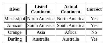
Consider the following pairs:

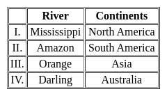
How many of the above mentioned pairs are correctly matched?

Detailed Solution: Question 10

The correct answer is Only three.
Important Points

Here is the justification for each:

Mississippi:

  • The Mississippi River is one of the longest rivers in North America, flowing through ten U.S. states, from Minnesota to the Gulf of Mexico.

Amazon:

  • The Amazon River is in South America, primarily flowing through Brazil and Peru.
  • It's the second longest river in the world and has the largest drainage basin on the planet, not to mention its crucial role in the Amazon Rainforest's ecosystem.

Orange:

  • The Orange River, contrary to what's listed in the table, is not in Asia.
  • It's actually the longest river in South Africa and forms part of the border between South Africa and Namibia.

Darling:

  • The Darling River is the third longest river in Australia, running through New South Wales.
  • It is part of the Murray-Darling river system, which is the longest river system in Australia.

UGC NET Paper 2 Geography Mock Test - 5 - Question 11

Globigerina ooze is

Detailed Solution: Question 11

The Correct Answer is Pelagic deposit.​

Key Points

  • This Globigerina ooze is the most densely spread of the oozes which occur both in the Atlantic and in the Indian oceans. While Pteropod ooze is found in the middle of the Atlantic.
  • globigerina ooze a layer of soft mud made up in large part of the shells of dead globigerina and covering great areas of the sea bottom at depths of 1000 to 3000 feet.
  • globigerina ooze formed
    • Globigerina ooze Deep-sea ooze in which at least 30% of the sediment consists of planktonic Foraminiferida, including chiefly Globigerina.
    • It is the most widespread deposit to form from the settling out of material from overlying waters, covering almost 50% of the deep-sea floor.

UGC NET Paper 2 Geography Mock Test - 5 - Question 12

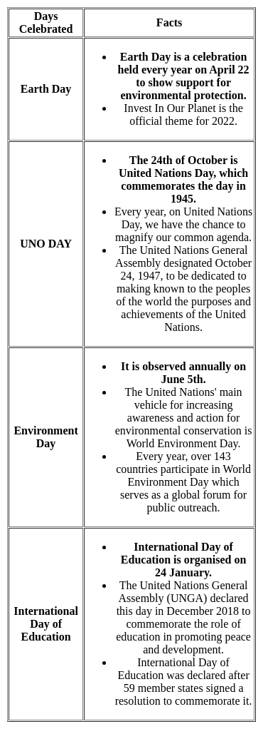
Match List I with List II :


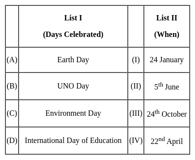
Choose the correct answer from the options given below :

Detailed Solution: Question 12

International days are opportunities for educating the general public about pressing concerns.

Key Points

Therefore, (A) - (IV), (B) - (III), (C) - (II), (D) - (I) is correct options.

Additional Information

  • On November 11, India commemorates the birth anniversary of India's first Education Minister, Maulana Abul Kalam Azad, with a National Education Day.
  • Azad was a major supporter of women's education.

UGC NET Paper 2 Geography Mock Test - 5 - Question 13

Who among the following is regarded as the founder of the humanistic approach in geography?

Detailed Solution: Question 13

The Correct Answer is Yi-Fu-Tuan.

Key Points

  • Humanistic School in Geography:
    • Chinese-American geographer Yi-Fu Tuan is the founder of the Humanistic School in Geography in 1976.
    • Human geography is distinguished by; - Human awareness - Human agency - Human consciousness - Human creativity.
    • The humanistic approach is a way of thinking in human geography; approach that seeks to put humans at the center of geography.
  • Well-known Humanist Geographers:
    • Anne Buttimer
    • Edward Relph
    • Yi-Fu Tuan
  • In 1976, it was Yi-Fu Tuan who argued for humanistic geography as concerned with people and their conditions.

Additional Information

  • Humanistic Geography (social & cultural geography) problems and Prospects: Edited by David Ley, Marawyn Samuels (1978).
  • Others included Humanistic geographers Edmunds Bunkse, Anne Buttimer, James Duncan, Jhon Western, etc
  • As a counter to the postulates of positivism, Leonard Guelke propounded the philosophy of idealism and urged human geographers, especially the historical geographers to probe into what humans, as decision-makers believed in and not why they believed.

UGC NET Paper 2 Geography Mock Test - 5 - Question 14

The system designed to capture, store, manipulate, analyze, manage and present spatial or geographical data can be termed as

Detailed Solution: Question 14

Concept:

GIS stands for the geographic information system. These are programs or a combination of programs that work together to help users make sense of their spatial data. This includes management, manipulation and customization, analysis, and creating visual displays.

Spatial data, also known as geospatial data, is a term used to describe any data related to or containing information about a specific location on the Earth’s surface. It exists in a variety of formats and contains more than just location-specific information.

G.I.S has following components

1. Hard ware (computer)

2. Software

3. Data management

4. End User and

5. Methods

The global positioning system (GPS) is a space based satellite navigation system that provides location and time information in all weather, anywhere or near the earth. It is maintained by the United States Government and is freely accessible to anyone. The GPS program critical capabilities to military, civil and commercial users around the world. In addition, GPS is the backbone for modernizing the global air traffic system.

UGC NET Paper 2 Geography Mock Test - 5 - Question 15

Harlan Barrows in the 1940s, for the first time proposed which term that encompasses the study of how human responses to the environment reflect the specific composition of the culture group involved?

Detailed Solution: Question 15

The correct answer is Cultural Ecology.

Important Points

  • Culture, behavior peculiar to Homo sapiens, together with material objects used as an integral part of this behavior. Thus, culture includes language, ideas, beliefs, customs, codes, institutions, tools, techniques, works of art, rituals, and ceremonies, among other elements.

Key Points

  • Cultural ecology is a methodological approach to investigating the relationship between humans and environments, considering culture as a key to understanding the evolutionary process, differently from other living beings.
  • Human ecology, man’s collective interaction with his environment. Influenced by the work of biologists on the interaction of organisms within their environments, social scientists undertook to study human groups similarly.
  • Human ecology, in the social sciences is the study of how the social structure adapts to the quality of natural resources and the existence of other human groups. When this study is limited to the development and variation of cultural properties, it is called cultural ecology.
  • Harlan Barrows in the 1940s, for the first time proposed a culture ecology term that encompasses the study of how human responses to the environment reflect the specific composition of the culture group involved.
  • Human ecology views the biological, environmental, demographic, and technical conditions of the life of any person as an interrelated series of determinants of form and function in human cultures and social systems.
  • It recognizes that group behavior is dependent upon resources and associated skills and upon a body of emotionally charged beliefs; these together give rise to a system of social structures.

Additional Information

  • Cultural diffusion describes the spread of one culture's practices, beliefs, and/or items, like food, music, or tools. This spread can be among members of the same culture or to completely different cultures around the world. Cultural diffusion is why many cultures around the world share similarities.

UGC NET Paper 2 Geography Mock Test - 5 - Question 16

Who in 1905 clearly expressed the logical arguments concerning the place of the Earth’s body in the field of Geography?

Detailed Solution: Question 16

Hettner in 1905 clearly expressed the logical arguments concerning the place of the Earth’s body in the field of Geography.

Key Points

Alfred Hettner (August 6, 1859 – August 31, 1941):

  • Alfred Hettner was a German geographer.
  • He is known for his concept of chorology, the study of places and regions, a concept that influenced both Carl O. Sauer and Richard Hartshorne.
  • Apart from Europe, his fieldwork concentrated mainly on Colombia, Chile, and Russia.
  • Alfred Hettner, who obtained his PhD from the University of Strasbourg, was also a pupil of Ferdinand von Richthofen and Friedrich Ratzel in Leipzig—where he obtained his habilitation.
  • His book Europe was published in 1907.
  • According to him, geography is a chorological science or it is a study of regions.
  • In his view, geography was fundamentally chorology, or the study of geographic distributions over the Earth’s surface. It was concerned with human interconnection and interaction with the natural environment, but it should also take into account the arrangement, by area, of the Earth’s physical phenomena. The study of local differences in phenomena over the Earth’s surface was the keynote of this concept.
  • Hettner rejected the view that geography could be either general or regional. Geography, like other fields of learning, must deal in both unique things (regional geography) and with the universal (general geography), but the study of regions — especially in the form of his Länderkunde approach — is the main field of geography.
  • For more than 40 years Hettner’s principal medium for disseminating his ideas on the scope and methodology of geography was the influential Geographische Zeitung (“Geographical Journal”), first published in 1899.
  • The first volume of his Grundzüge der Länderkunde (1907; “Foundations of Regional Geography”) dealt with Europe, but its companion volume, on other regions, did not appear until 1924.
  • He also wrote Vergleichende Länderkunde, 4 vol. (1933–35; “Comparative Regional Geography”).
  • One of the major works of geographic literature, the 11-volume Handbuch der Geographischen Wissenschaft (“Handbook of Geographical Science”), completed in 1940, was his conception.
  • Hettner supervised, among others, the PhDs of Oskar Schmieder, Friedrich Metz, and Heinrich Schmitthenner.

UGC NET Paper 2 Geography Mock Test - 5 - Question 17

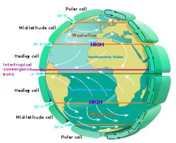
Assertion (A): In southern hemisphere, westerlies are stronger with very high velocity of winds than in the northem hemisphere.

Reason (R): In southern hemisphere, there is vast expanse of ocean and therefore westerlies attain terrific speed.

Detailed Solution: Question 17

The correct reason is Both (A) and (R) are individually true and (R) is the correct explanation of (A).

Key Points

  • The westerlies are steadier and stronger in the southern hemisphere because they face minimal land interference as compared to the northern hemisphere.
    • Land interference causes obstruction in the flow of wind in the northern hemisphere, thus slowing the westerlies.
    • Hence (R) is the correct explanation of (A).
  • The prevailing wind in a region of the Earth's surface is a surface wind that blows predominantly from a particular direction.
    • The dominant winds are the trends in direction of the wind with the highest speed over a particular point on the Earth's surface.

  • Hence, option 4 is correct.

Additional Information

  • Westerlies
    • The westerlies are the winds blowing from the subtropical high-pressure belts towards the sub-polar low-pressure belts.
    • They blow from south­west to north-east in the northern hemisphere and north-west to south-east in the southern hemisphere.
    • The westerlies of the southern hemisphere are stronger and persistent due to the vast expanse of water, while those of the northern hemisphere are irregular because of uneven relief of vast land masses.
    • The westerlies are best developed between 40° and 65°S latitudes.
      • These latitudes are often called Roaring Forties, Furious Fifties, and Shrieking Sixties – dreaded terms for sailors.
    • The poleward boundary of the westerlies is highly fluctuating. There are many seasonal and short-term fluctuations. These winds produce wet spells and variability in weather.
  • Polar easterlies
    • The Polar easterlies are dry, cold prevailing winds blowing from north-east to south-west direction in Northern Hemisphere and south-east to the north-west in Southern Hemisphere.
    • They blow from the polar high-pressure areas of the sub-polar lows.

UGC NET Paper 2 Geography Mock Test - 5 - Question 18

Consider the following statements about human environment interaction and state which amongst the following is true:

i. The type of society has strong influence over the environment .

ii. Human characteristics have impact on the environment.

iii. Education is a key factor on people’s view of life.

iv. Ecosystem services are important for human well-being.

Choose the correct option from below:

Detailed Solution: Question 18

 Human environment interaction involves understanding of human characteristics. The type of society strongly influences people’s attitude towards nature, their behavior, and therefore their impact on ecosystem. Important characteristics of human social systems are population size, social organization, values, technologies etc.

Thus, the Correct answer is D.

UGC NET Paper 2 Geography Mock Test - 5 - Question 19

Which fault line is the most active fault line in Himalaya system?

Detailed Solution: Question 19

 The Main Central Thrust (MCT) lies between Greater Himalayas and Lesser Himalayas. Many earthquakes have occurred along this fault line. Some of these include earthquakes at Srinagar in 2005, Kandla in 1905, Uttarkashi in 1993 and Kathmandu in 2015. It is the most active fault line in Himalayan mountain system.

Thus, the correct answer is A.

UGC NET Paper 2 Geography Mock Test - 5 - Question 20

Which among the following is the largest Bay of the world?

Detailed Solution: Question 20

Bay of Bengal is the largest bay in the world. It is located to southeast of India. The Hudson bay comes second.

UGC NET Paper 2 Geography Mock Test - 5 - Question 21

Consider the following statements on digital image processing and choose which amongst them is true:

i. The process of digital image process is also called satellite image processing.

ii. Image pre-processing, Image enhancement and image classification are classification of digital image processing.

iii. The process is widely preferred.

iv. satellite images contain no errors. .

Detailed Solution: Question 21

Digital image processing is a technique which involves manipulation of digital image to extract information. When satellite images are being manipulated in such manner, this technique is also referred to as satellite image processing. It involves combination of software based image processing tools. There are three classification of digital image processing.

Thus, the correct answer is C.

UGC NET Paper 2 Geography Mock Test - 5 - Question 22

Consider the following statements:-

a) Culture has no precise standard of measurement.

b) Brock and Webb has divided the world into 5 major and 3 minor cultural realms.

c) According to H. Robinson, the European cultural region is the most favourable continent.

d) Cultural regions and areas both are the same.

Which of the following options are correct?

Detailed Solution: Question 22

Culture cannot be measured. The work standard of a person cannot be measured with another person's work. Culture is a social concept and is constantly changing and adapting.

Brock and Webb has divided the world into 4 major and 2 minor cultural realms. Occidental realm, Islamic, Indian and east Indian cultural realm are the major ones while south east Asian, Meso African are the minor cultural realms.

Europe has a large acre of agricultural land than any other continent and there are no deserts. Its mineral wealth is considerable and varied as well as the trade conditions exceed that of Europe. The mixing of European races results in a variety of energetic and inventive people.

Cultural area is a concept of cultural geography, in which a geographic region and time sequence is characterised by substantially uniform environment and culture. The present boundaries of states in India, which have been drawn on the basis of languages, generally represent cultural areas while cultural region is a portion of the Earth's surface that has common cultural elements.

UGC NET Paper 2 Geography Mock Test - 5 - Question 23

Match List-I with List-II :

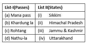
Select the correct answer from the options given below:

Detailed Solution: Question 23

  • The Mana pass derives from a name of a village with the same name in Uttarakhand. It’s last village on the border of Uttarakhand. Trade here is carried out with the help of mules.
  • Khardung la is a pass in Jammu & Kashmir. At 18000 ft above the sea level, it’s the highest motor able road in the world.
  • The famous Rohtang pass in Himachal Pradesh connects the Kullu Valley with Spiti and Lahual Valley.
  • Nathu la is a pass in Sikkim that lies in East Sikkim district and serves as one of the open trading posts on the border with China.

Thus, the correct answer is B.

UGC NET Paper 2 Geography Mock Test - 5 - Question 24

What kind of products were exported by Canada during the 19th century?

Detailed Solution: Question 24

During the 19th century, Canada was a major exporter of primary products, mainly to the United Kingdom. The greatest single export item is forest products which accounts for a third of the annual total. After that comes wheat and flour and many important minerals.

UGC NET Paper 2 Geography Mock Test - 5 - Question 25

Given below are two statements. One is labelled as Assertion (A) and the other is labelled as Reason (R).

Assertion (A): Peninsular Rivers have broad and shallow valleys.

Reason (R): Peninsular Rivers have a low capacity to carry load.

Select the correct answer from options given below:

Detailed Solution: Question 25

Rivers in Indian peninsula have almost reached base level of their erosion. They are in the mature stage which is evident through their broad and shallow valleys and the deltas that they make. The velocity of water in their channel and their capacity to carry load is also less. The reason for this is that the peninsular rivers have existed for a much longer period of time as compared to the Himalayan Rivers. Thus, both (A) and (R) are true but (R) is not the correct explanation of (A).

UGC NET Paper 2 Geography Mock Test - 5 - Question 26

As per the Census 2011, which state has the lowest population in India?

Detailed Solution: Question 26

As per the Census of 2011 the population of Sikkim is 619,000 which is lowest in India. Sikkim is located at trijunction of India with China (Tibet), Nepal and Bhutan.

UGC NET Paper 2 Geography Mock Test - 5 - Question 27

Which state is the largest producer of wheat in India ?

Detailed Solution: Question 27

Uttar Pradesh is the largest Wheat producing state of India, followed by Punjab, Haryana and Madhya Pradesh.

UGC NET Paper 2 Geography Mock Test - 5 - Question 28

Use the information below to answer the question that follows.

  1. fluctuating water table
  2. large herbivores, carnivores, and scavengers
  3. tall, coarse grass
  4. low-growing, drought-resistant tree species

The information presented best describes major features of which of the following grassland biomes?

Detailed Solution: Question 28

This question requires the examinee to demonstrate knowledge of the distribution and characteristics of major global and regional ecosystems. Major tropical savanna grasslands can be found in northern and eastern India, northern Australia, south central Africa, western Central America, and the Llanos region of Venezuela. Their major features include fluctuating water tables, leached soils, large herbivores, carnivores, and scavengers, tall, coarse grass, and scattered low-growing, drought-resistant trees, scrub, and thorn bushes.

UGC NET Paper 2 Geography Mock Test - 5 - Question 29

Compared with North American cities, western European cities are generally more compact, with lower skylines, narrower streets, and more irregular street patterns. This difference is primarily a reflection of the:

Detailed Solution: Question 29

This question requires the examinee to demonstrate knowledge of the purposes, organization, and functions of diverse human settlements; processes influencing the establishment of human settlements; and the ways in which settlements change over time. The compact form, low skylines, narrow streets, and irregular street patterns of many western European cities are vestiges of their medieval origins. Although current urban patterns in the region are largely the product of nineteenth- and twentieth-century construction programs, builders very often retained major features of the earlier urban landscape.

UGC NET Paper 2 Geography Mock Test - 5 - Question 30

It is essential to pay more regard to which of the following two things while classifying maps into different categories?

Detailed Solution: Question 30

Scales are required to navigate maps correctly. It gives you an accurate understanding of distance. For example if the scale on a map states: 1:100000 or is 1:100000 scale map. Then that would mean that 1cm on the map would equal 1 km scale on the ground.

View more questions
959 docs|159 tests
Information about UGC NET Paper 2 Geography Mock Test - 5 Page
In this test you can find the Exam questions for UGC NET Paper 2 Geography Mock Test - 5 solved & explained in the simplest way possible. Besides giving Questions and answers for UGC NET Paper 2 Geography Mock Test - 5, EduRev gives you an ample number of Online tests for practice
Download as PDF