AP TET Exam  >  AP TET Tests  >  APSET Paper 2 Mock Test - 9 (Geography) - AP TET MCQ

APSET Paper 2 Mock Test - 9 (Geography) - AP TET MCQ


Test Description

30 Questions MCQ Test - APSET Paper 2 Mock Test - 9 (Geography)

APSET Paper 2 Mock Test - 9 (Geography) for AP TET 2024 is part of AP TET preparation. The APSET Paper 2 Mock Test - 9 (Geography) questions and answers have been prepared according to the AP TET exam syllabus.The APSET Paper 2 Mock Test - 9 (Geography) MCQs are made for AP TET 2024 Exam. Find important definitions, questions, notes, meanings, examples, exercises, MCQs and online tests for APSET Paper 2 Mock Test - 9 (Geography) below.
Solutions of APSET Paper 2 Mock Test - 9 (Geography) questions in English are available as part of our course for AP TET & APSET Paper 2 Mock Test - 9 (Geography) solutions in Hindi for AP TET course. Download more important topics, notes, lectures and mock test series for AP TET Exam by signing up for free. Attempt APSET Paper 2 Mock Test - 9 (Geography) | 100 questions in 120 minutes | Mock test for AP TET preparation | Free important questions MCQ to study for AP TET Exam | Download free PDF with solutions
APSET Paper 2 Mock Test - 9 (Geography) - Question 1

For interpolation of satellite data used for monitoring dynamic changes that occur on the earth surface, the most suitable orbit for the satellite is:

Detailed Solution for APSET Paper 2 Mock Test - 9 (Geography) - Question 1

Explanation:

Sun-synchronous orbit

  • Sun-synchronous orbits are designed to synchronize with the Sun's position in the sky, allowing the satellite to pass over any given point on the Earth's surface at the same local solar time during each orbit.
  • This ensures consistent lighting conditions, making it ideal for monitoring and imaging purposes.
  • The regularity of lighting is crucial for comparing images and data collected over time.

Additional InformationNear polar orbit 

  • Near polar orbits are characterized by a satellite orbiting the Earth from pole to pole.
  • These orbits are often used for Earth observation satellites because they provide global coverage.
  • Near polar orbits are suitable for monitoring dynamic changes as they allow the satellite to observe different parts of the Earth's surface during each orbit.

Circular orbit

  • A circular orbit is one in which the satellite travels in a path that is a perfect circle.
  • While circular orbits have their uses, they might not be the most suitable for monitoring dynamic changes on the Earth's surface because they do not provide a consistent illumination angle and lighting conditions.
APSET Paper 2 Mock Test - 9 (Geography) - Question 2

‘The structure of movement and household travel behavior’ was given by

Detailed Solution for APSET Paper 2 Mock Test - 9 (Geography) - Question 2

M.E. Hurst was an American geographer who focused on transport geography and gave emphasis on behavioral geography. In his paper of the same name, he published the structure of movement and household travel behavior where he took into consideration the factors motivating household travels.

Thus, the correct answer is D.

1 Crore+ students have signed up on EduRev. Have you? Download the App
APSET Paper 2 Mock Test - 9 (Geography) - Question 3

Consider the following States:

1. Karnataka

2. Andhra Pradesh

3. Goa

4. Rajasthan 

Which of the above are the major maize-producing states?

Detailed Solution for APSET Paper 2 Mock Test - 9 (Geography) - Question 3

The correct answer is Option 4.

  • In India, maize is grown in Karnataka, Madhya Pradesh, Maharashtra, Telangana, Rajasthan, Tamil Nadu, Bihar, Uttar Pradesh, and Gujarat.​

Key PointsMaize

  • In India, maize is the third most important food crop after rice and wheat.
  • Maize in India contributes nearly 9% of the national food basket.
  • In addition to staple food for human beings and quality feed for animals,
  • It serves as a basic raw material ingredient in industrial products, including-
    • starch, oil, protein, alcoholic beverages, food sweeteners, pharmaceutical, cosmetic, film, textile, gum, package and paper industries, etc.
  • The predominant maize-growing states that contribute more than 80 % of the total maize production are:
    •  Andhra Pradesh (20.9 %), Karnataka (16.5 %), Rajasthan (9.9 %), Maharashtra (9.1 %), Bihar (8.9 %), Uttar Pradesh (6.1 %), Madhya Pradesh (5.7 %), Himachal Pradesh (4.4 %).
  •  Apart from these states, maize is also grown in Jammu and Kashmir, and North-Eastern states.
  • Hence, maize has emerged as an essential crop in non-traditional regions.
  • State like Andhra Pradesh which ranks 5th in the area (0.79 m ha) has recorded the highest production (4.14 mt) and productivity (5.26 t/ha ) in the country.

Additional InformationRequirement for maize production:

  • It is a Kharif crop.
  • Irrigation facilities, usage of fertilizers, and usage of High Yielding Variety (HYV) seed contributed to the massive increase in maize production in India.
  • Maize grows well in temperatures ranging from 21°C to 27°C.
  • It grows well in old alluvial soil.
  • maize is a warm-weather crop
  • it cannot survive freezing
  • Therefore, the best soils for maize growth should have a sufficient ability to hold water and efficient drainage.
APSET Paper 2 Mock Test - 9 (Geography) - Question 4
Isohalines are lines joining equal:
Detailed Solution for APSET Paper 2 Mock Test - 9 (Geography) - Question 4

The correct answer is salinity.

Key Points

  • Isohalines
    • It is used on maps to show the salinity of different places. Hence, Option 4 is correct.
    • The average salinity of the ocean is 3.5% or 35 parts of salt in 1000 parts of water.
    • The salinity of the Great Salt Lake, (Utah, USA), the Dead Sea, and the Lake Van in Turkey are 220, 240, and 330 respectively.
    • The oceans and salt lakes are becoming saltier as time goes on because the rivers dump more salt into them, while freshwater is lost due to evaporation.
  • The more frequently drawn isopleths include:
    • Isotherm (equal temperature)
    • Isobar (equal pressure)
    • Isohyets (equal rainfall)
    • Isonephs (equal cloudiness)
    • Isohels (equal sunshine)
    • contours (equal heights)
    • Isobaths (equal depths)
APSET Paper 2 Mock Test - 9 (Geography) - Question 5

Given below are two statements. One is labelled as Assertion (A) and the other is labelled as Reason (R).

Assertion (A): Software industry has developed rapidly in India since 1990s.

Reason (R): India has a lot of technically skilled manpower.

Select the correct answer from options given below:

Detailed Solution for APSET Paper 2 Mock Test - 9 (Geography) - Question 5

The software industry is one of the leading industries in India. This industry had a breakthrough and has developed rapidly since 1990s. The reason for such unprecedented development is that there is abundance of skilled technicians in India who are very skilled at software development.

APSET Paper 2 Mock Test - 9 (Geography) - Question 6

Given below are two statements. One is labelled as Assertion (A) and the other is labelled as Reason (R).

Assertion (A): Foreign Direct Investment is not beneficial for economic growth.

Reason (R) : Foreign Direct Investment increases trade in the economy.

Select the correct answer from options given below:

Detailed Solution for APSET Paper 2 Mock Test - 9 (Geography) - Question 6

Foreign Direct Investment means that companies from other countries invest in the companies in the host country. This provides employment to workers and increases the foreign currency in the country. Utilization of available resources is also done. The FDI facilitates trade as the amount of finished product increase. Thus, it is helpful for economic growth. Thus, (R) is true and (A) is false.

APSET Paper 2 Mock Test - 9 (Geography) - Question 7

Study the following pairs (P, Q, R, S) with respect to GPS receivers used in GPS surveys and select the correct answer based on the matching.

P : GPS receivers : L-band radio processor

Q : Self-contained GPS receivers : Also known as 'GPS mice'

R : Dual-frequency receivers : Survey grade GPS, position accuracy according to differential correction within sub-centimetre

S : Carrier phase receivers : GPS receivers with 10 to 30 cm position accuracy with differential correction

Detailed Solution for APSET Paper 2 Mock Test - 9 (Geography) - Question 7

Explanation

GPS Receivers -  A GPS receiver is an L-band radio processor. It processes the signal broadcast by GPS satellites, solves the equations for navigation so that user can easily compute their position, precise time & velocity.

Types of GPS Receivers

  1. On the basis of features
  2. On the basis of level of accuracy


Types of GPS Receivers on the basis of features-

  • Not-self-contained receivers: also known as 'GPS mice'. These are without screen and are need to be connected to a computer for the purpose of visualization of real position of GPS receiver.Bluetooth (wireless) can be the link of connection between the GPS and computer. This type is best used in car-navigation systems.
  • Self contained receivers: have a screen and is integrated with the computer itself. Sometimes. additional features e.g. electronic compass, barometer etc. are found in this type. It is primarily used in boating and aviation.
  • Sophisticated receivers: are meant for professional use. e.g. in the field of mapping & GIS. transportation safety, crop & agriculture etc. Though the working principle remains the same as others, the only important difference is its storage capacity and higher accuracy, which helps to store a larger amount of data that can be treated later in the office.

Types of GPS Receivers on the basis of different levels of accuracy-

  • C/A Code receivers: These receivers have the accuracy of 1 to 5 m related to position and differential correction so that getting an occupation time of 5 seconds. The recent advancement in the GPS receiver design now enables it to provide sub-meter accuracy down to 30 cm.
  • Carrier Phase receivers: These receivers provide 10-30 cm GPS position accuracy with differential correction. The distance from the receiver to the satellite is measured by determining the total number of waves which supports the C/A code signal, which is more accurate and takes about 5 minutes of the occupation time.
  • Dual-Frequency receivers: provide GPS position accuracy according to differential correction within sub centimeter & accuracy according to survey grade. These receivers are presented with the signals from satellites on the basis of two frequencies at the same time. The use of two frequencies will help in omission of atmospheric and other errors and thus improving the accuracy.
APSET Paper 2 Mock Test - 9 (Geography) - Question 8
The most suitable site for Ocean (tidal) energy is:
Detailed Solution for APSET Paper 2 Mock Test - 9 (Geography) - Question 8

The correct answer is Gulf of Khambat (Cambay).

Key Points

  • The most attractive locations are the Gulf of Cambay and the Gulf of Kachchh on the west coast.
    • The maximum tidal range is 11 m and 8 m with an average tidal range of 6.77 m and 5.23 m respectively.
    • The Ganges Delta in the Sunderbans in West Bengal also has good locations for small-scale tidal power development.
  • The tidal power potential in India is of the order of 8000-9000 MW with about 7000 MW in the Gulf of Cambay. 

Additional Information

  • What is Tidal Energy?
    • Tides are a regular phenomenon. They can be predicted over months and years in advance. This is why the energy from this massive movement of water can be harnessed and converted into a usable form of energy.
  • Some advantages of tidal energy are:
    • Environment-friendly
    • A highly predictable energy source
    • High energy density
  • Some disadvantages of tidal energy are:
    • ​High tidal power plant construction costs.
    • Negative influence on marine life forms.
    • Location limits.
APSET Paper 2 Mock Test - 9 (Geography) - Question 9

The temperature-depth profile of the ocean is an interesting topic of study. Which of the following statements is/are incorrect regarding this?

1. About 90 per cent of the total volume of water is found below the thermocline in the deep ocean.

2. The thermocline layer is characterised by a rapid decrease in temperature with increasing depth.

3. The highest temperature of the ocean waters is recorded at the equator.

Identify the correct answer from the codes given below.
Detailed Solution for APSET Paper 2 Mock Test - 9 (Geography) - Question 9
  • The temperature-depth profile shows a boundary region between the surface waters of the ocean and the deeper layers. This boundary region, from where there is a rapid decrease of temperature, is called the thermocline.
  • About 90 per cent of the total volume of water is found below the thermocline in the deep ocean. Hence Statement 1 is correct.
  • The thermocline layer is 500 to 1000m thick and is characterised by rapid decrease in temperature with increasing depth. Hence Statement 2 is correct.
  • The rate of decrease of temperature with increasing latitude is generally 0.5°C per latitude.
  • The oceans in the northern hemisphere record relatively higher temperatures than in the southern hemisphere. The highest temperature is not recorded at the equator but slightly towards north of it. Hence Statement 3 is incorrect.
APSET Paper 2 Mock Test - 9 (Geography) - Question 10
A passive sensor uses:
Detailed Solution for APSET Paper 2 Mock Test - 9 (Geography) - Question 10

Explanation:

There are two types of sensors in remote sensing:

1) Passive remote sensing (Sensor):

  • It depends on a natural source to provide energy for data collection. Sun is the most commonly used source of energy for passive remote sensing.
  • However, passive remote sensing can be done in absence of the Sun. In this case, the target material itself is the source of energy, and the sensor records primarily emitted radiation.
  • Examples: Return bram vidicon, Electro-optical scanner, and Electro-optical radiometer use light as the primary source.

2) Active remote sensing (Sensor):

  • It uses a man-made source of energy. In this case, humans can manipulate the nature of source energy (wavelength, power, duration).
  • Examples: Radar
APSET Paper 2 Mock Test - 9 (Geography) - Question 11

Choose the correct option for the statements gien below:

(A) Endogenic forces sometimes produce sudden movements

(B) Sudden moments like earthquakes and volcanoes cause mass destruction on the surface of the earth

Detailed Solution for APSET Paper 2 Mock Test - 9 (Geography) - Question 11

The correct answer is Both (A) and (B) are correct and (B) is the correct explanation of (A).

Key PointsThe question is related to endogenic forces and their impact on the earth's surface.

  • Option 1 is the correct answer, which states that both statements are correct, and (B) is the correct explanation of (A).
  • The following points support this answer: - Endogenic forces such as tectonic plate movements and volcanic eruptions can cause sudden movements, which can result in earthquakes and volcanic eruptions.
  • These sudden movements can cause mass destruction on the earth's surface, as stated in statement (B). - Statement (B) explains the impact of sudden movements caused by endogenic forces, which makes it the correct explanation of statement (A).
  • Option 2 is incorrect as it states that both statements are correct, but (B) is not the correct explanation of (A), which is not true, as explained above.
  • Option 3 is incorrect as it states that (A) is correct and (B) is incorrect, which is not true as a statement (B) is also correct.
  • Option 4 is incorrect as it states that (A) is incorrect and (B) is correct, which is not true as a statement (A) is also correct.

Additional Information

  • Endogenic forces are the internal forces of the earth that originate from within the earth's surface.
  • Exogenic forces are the external forces of the earth that originate from outside the earth's surface, such as wind, water, and ice.
  • The impact of endogenic forces can be seen in the form of earthquakes, volcanic eruptions, and mountain formations.
  • The impact of exogenic forces can be seen in the form of erosion, weathering, and deposition.
APSET Paper 2 Mock Test - 9 (Geography) - Question 12
Which is the shallowest part of the ocean, showing an average gradient of 1° or even less and it typically ends at a very steep slope?
Detailed Solution for APSET Paper 2 Mock Test - 9 (Geography) - Question 12

The correct answer is Continental Shelf.

Key Points

  • Continental Shelf is the shallowest part of the ocean, showing an average gradient of 1° or even less and it typically ends at a very steep slope.
  • Continental Shelf:
    • It is the gently sloping seaward extension of the continental plate.
    • It is the shallowest part of the ocean.
    • These are created due to sedimentation from the continents.
    • Continental Shelf is the gently sloping seaward extension of the continental plate.
    • The continental shelves are covered with variable thicknesses of sediments brought down by rivers, glaciers, etc.
    • The shelves are almost absent or very narrow along some of the margins like the coasts of Chile, the west coast of Sumatra, etc. [Ocean - Continent Convergence and Ocean - Ocean Convergence].
    • Continental shelves are located in photic zones, so have rich marine ecology.
    • The Continental Shelf of all oceans together covers 7.5% of the total area of the oceans.

Additional Information

  • Ocean Floor Division can be divided into various parts such as Continental Shelf, Continental Slope, Continental Rise or Foot, Deep Ocean basins, Abyssal plains or Deep Sea plain, Oceanic Trenches, Seamounts, and Guyots.
  • Deep-Sea Plain or Abyssal plain:
    • These plains are gently sloping areas of the ocean basins.
    • These are the flattest and smoothest regions of the world.
    • It is an underwater plain on the deep ocean floor, usually found at depths between 3,000 and 6,000m.
    • These plains are covered with fine-grained sediments like clay and silt.
    • Lying generally between the foot of a continental rise and a mid-ocean ridge, abyssal plains cover more than 50% of the Earth's surface.
  • Oceanic Deeps or Trenches:
    • These areas are the deepest parts of the oceans.
    • The trenches are relatively steep-sided, narrow basins.
    • They are some 3-5 km deeper than the surrounding ocean floor.
    • They occur at the bases of continental slopes and along island arcs and are associated with active volcanoes and strong earthquakes.
  • Continental Slope:
    • The continental slope ties the continental shelf and the rising of the continent.
    • The continental shelf stops as the slope rises sharply. From here, the continental slope begins.
    • A sudden change in the gradient to around 1 in 20 occurs. With young mountain ranges and narrow continental shelves, the slope gradient is highest off coasts and lowest off stable coasts without large rivers.
    • Most Pacific slopes are steeper than Atlantic slopes.
APSET Paper 2 Mock Test - 9 (Geography) - Question 13
Read the following statements and select the correct answer from the code given below.

(a) Ratzel applied organic theory to biogeography.

(b) Humboldt was of the opinion that life of people living in islands, plains and mountains was similar.

(c) Kant described the impact of environment in late 18th century.

(d) Darwin’s theory of origin of species is dependent on the idea that the nature changes with time.

Code:

Detailed Solution for APSET Paper 2 Mock Test - 9 (Geography) - Question 13

Ratzel developed the concept of Lebensraum (living space). In that he applied the concepts of organic theory to Political Geography. Humboldt travelled extensively through the world and noted that the mode of life was different in different places, such as coastal plains differed from islands, river basins or mountainous regions. Immanuel Kant, in 18th century concluded from his research that environment had a huge impact on human lifestyle. Charles Darwin, in his book Origin of species claimed that things in nature change with time.

Thus, the correct answer is D.

APSET Paper 2 Mock Test - 9 (Geography) - Question 14
Read the following statements and choose the correct answer from the code given below:

(a) Altimetric frequency histograms and curves are two basic techniques to study high lands of geomorphological significance.

(b) Baulig suggested use of grid method to remove deficiencies in altimetric analysis.

(c) The accuracy of altimetric analysis depends upon the benchmarks.

(d) The grid method is used in altimetric analysis when there is deficiency in density of spot heights.

Code:

Detailed Solution for APSET Paper 2 Mock Test - 9 (Geography) - Question 14

Altimetric analysis is the use of altimetric frequency histograms and curves for study of geomorphological significance. The accuracy of altimetric analysis depends on the density of spot-heights in an area. The grid method was suggested by Baulig to remove the deficiencies in density of spot-height. It is common to use grid method when there is deficiency in density of spot-heights.

APSET Paper 2 Mock Test - 9 (Geography) - Question 15

Read the following statements and state which of them are true?

Spykman's Rimland Theory was a variant of Mackinder's Heartland Model. Both the models emphasised on

Detailed Solution for APSET Paper 2 Mock Test - 9 (Geography) - Question 15

The correct answer is the Role of the value of location in determining the political destiny of the world.

Key Points

  • Mackinder’s theory is a spatial analysis of the geopolitics in terms of its location, accessibility, and natural resource base. His theory has laid down the principle of geographical causation of history which means that the pulsations in human history have been caused by geographical conditions.
  • Mackinder interpreted history as essentially a struggle between Land & Sea Power and presented his paper “The Geographical Pivot of History” to elucidate his formula of Geographical Causation in World History.
  • For him, whoever could gain control of ‘World Island’ would be in an almost unstoppable position to dominate the entire globe. In his opinion, the heartland having Agricultural resources could conquer Europe, the Middle East & Far East.
  • The world power seemed to be centralized around the Heartland which he said had all the resources and natural defense by the physiographic factors. It is invincible and represents the supremacy of Land Power which political destiny of the world.
  • According to Mackinder -“Who rules East Europe commands the Heartland?” “Who rules Heartland commands the World-Island?” “Who rules the World-Island commands the World?”.
  • In 1944, Spykman as the point of critic or antithetic to the Heartland Theory presented his work titled “The Rimland Theory” in his book – “The Geography of Peace”. He gave a different interpretation of the relative importance of Heartland (Land Power) vis-a-vis the surrounding Inner and Outer Crescent
  • According to Spykman Sea Power has faster movement, and greater accessibility while Land can be inaccessible due to hills, rivers, deserts, etc. Sea Powers has more than 2/3rd the population of the world and is thus full of human & technological resources. Most of the population is located in Coastal areas.
  • Spykman considered geographical features as important determinants in foreign policy because of their emphasis on spatial variations.
  • In medieval human history and the pre-modern era, Naval Power had supremacy over Land power as they had Navigation Technology, Ships, etc. e.g. British, French, Germany, Portuguese, Spanish, and Italy were all sea powers and the whole world became a colonial house of these countries.
APSET Paper 2 Mock Test - 9 (Geography) - Question 16

Which of the following is not correctly matched:

Approaches - Periods
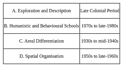
Detailed Solution for APSET Paper 2 Mock Test - 9 (Geography) - Question 16

With this, new approaches can cross like welfare or humanistic school of thought, radical school of thought and behavioural school of thought.

APSET Paper 2 Mock Test - 9 (Geography) - Question 17
Given below are the two statements, one labelled as Assertion (A) and the other labelled as Reason (R). Select your answer from the code given below :

Assertion (A) : In the concentric zone model the rich high-class citizens live in the fourth zone.

Reason (R) : Detached homes are found in the fourth zone which is at quite a bit of distance from the Central Business District.

Code :

Detailed Solution for APSET Paper 2 Mock Test - 9 (Geography) - Question 17

The Concentric zone model was given by Ernest Burgess. In this model he divided the structure of the city into 5 zones. These include the Central Business District, Transition zone, working class zone, residential zone and commuter’s zone. The fourth or the residential zone is home to the middle-class people, who have amenities like parks, shops, gardens, lawns, etc. The houses here are detached. The rich, affluent people live in the commuter’s zone, away from the city. These people can afford large houses and cost of the commute.

Thus, the correct answer is D.

APSET Paper 2 Mock Test - 9 (Geography) - Question 18
One of the purposes of this sampling technique is to ensure that all sections of the population are adequately represented. Identify the Sampling technique:-
Detailed Solution for APSET Paper 2 Mock Test - 9 (Geography) - Question 18

Stratified Sampling is the only technique where all the sections of the population or sub-population are homogenously and adequately represented. Stratified sampling is generally used when the population is heterogenous but can be subdivided into strata within each of which the heterogeneity is not so prominent. If a proper stratification can be made such that the strata differ from one another as much as possible, but there is much homogeneity within each of them , then stratified sample will yield better results. Here the sub-sample sizes are made proportional to the sub population sizes.

Thus, the Correct answer is B.

APSET Paper 2 Mock Test - 9 (Geography) - Question 19

Which scale is used to measure three dimensions on a scale?

Detailed Solution for APSET Paper 2 Mock Test - 9 (Geography) - Question 19

Scale: In order to prepare a drawing of any size, a scale is essential. E.g. 1 cm = 1 metre (m)

Classification of scales:

  • Plain Scales
  • Diagonal Scales
  • Comparative Scales
  • Vernier Scales
  • Chord Scales

(i) Plain Scale is used to measure up to two consecutive units, i.e. a unit and its immediate sub division. For example (a) metre and decimetre (b) kilometre and hectometre (c) feet and inches etc.

(ii) Diagonal Scale is used to represent three consecutive units i.e. a unit and its immediate two sub divisions. For example (a) metre, decimetre and centimetre (b) kilometre, hectometre and decametre (c) yards, feet and inches etc. A diagonal scale can measure more accurately than a plain scale.

APSET Paper 2 Mock Test - 9 (Geography) - Question 20
Which of the following lakes of India is not a lagoon?
Detailed Solution for APSET Paper 2 Mock Test - 9 (Geography) - Question 20
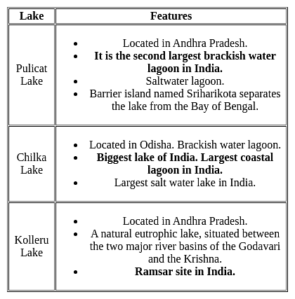
Lagoon is a shallow body of water which is separated and protected from a larger body of water. Two major types of lagoons are coastal lagoons and atoll lagoons. Word ‘Lagoon’ finds its origin in the Italian term ‘‘laguna” which implies lake or pond. Famous lagoons in India are Pulicat, Chilka, Vembanad,etc are. 
Key Points
Additional InformationLoktak Lake:
  • It is located in Manipur.
  • Largest natural freshwater lake in North-East and also in India.
  • Famous Keibul Lamjao National Park is also located here. It is the only floating national park in the world.
  • Economically important lake in India. 
  • It is famous for the phumdis.
APSET Paper 2 Mock Test - 9 (Geography) - Question 21

When was National environment planning and coordination (NEPC) established?

Detailed Solution for APSET Paper 2 Mock Test - 9 (Geography) - Question 21

In February 1972, National environment planning and coordination (NEPC) was established. This was the body that looked after all the environmental issues, plans, and polities. It was established in the Department of Science and technology.

APSET Paper 2 Mock Test - 9 (Geography) - Question 22
Terra-Incognita concept given by-
Detailed Solution for APSET Paper 2 Mock Test - 9 (Geography) - Question 22

The correct answer is Ptolemy. Key PointsTerra-Incognita:Terra incognita or terra ignota (Latin "unknown land"; incognita is stressed on its second syllable in Latin, but with variation in pronunciation in English) is a term used in cartography for regions that have not been mapped or documented. The expression is believed to be first seen in Ptolemy's Geography c. 150.

  • The term was reintroduced in the 15th century from the rediscovery of Ptolemy's work during the Age of Discovery.
  • The equivalent on French maps would be terres inconnues (plural form), and some English maps may show Parts Unknown.


Additional Information

Contributions of Ptolemy:

  • Planetary hypothesis
  • Text on classical astronomy entitled ‘Almagest’ ( the mathematical treatise)
  • The Geography/ The Guide to Geography
  • The optics and The Tetrabiblos
  • Astrology
  • Explore the Terra-Incognita (the unknown land)
  • A detailed topographical description of places and their history called ‘chorography’
  • He said 'geography is the science which deals with the art of map-making.'
APSET Paper 2 Mock Test - 9 (Geography) - Question 23

_______ are lines drawn on a map to locate, in the plan view, points of equal ground elevation.

Detailed Solution for APSET Paper 2 Mock Test - 9 (Geography) - Question 23

The line joining the points of equal elevation on ground called contour line and the difference of elevation between two consecutive contours is called contour intervals.

Important points about Contour Line:

  1. Contour line never cross each other and never joins at one location except Vertical Cliff or overhang.
  2. All contours on earth surface are always closed contours.
  3. Contours of small spacing indicate steep slope and contour of large spacing indicate mild or gentle slope.
  4. If some contours are found in small map or small area then it indicates a pond or hill in that area.
APSET Paper 2 Mock Test - 9 (Geography) - Question 24

The method of mapping depends on the

Detailed Solution for APSET Paper 2 Mock Test - 9 (Geography) - Question 24

The method of mapping depends on the Size of the area, Degree of accuracy aimed at, Amount of details required.

APSET Paper 2 Mock Test - 9 (Geography) - Question 25

Critics of the Malthusian Theory argue that advancements in which field have mitigated the challenges predicted by Malthus?

Detailed Solution for APSET Paper 2 Mock Test - 9 (Geography) - Question 25

Option 3) Agriculture and resource management

Critics of the Malthusian Theory contend that the challenges predicted by Reverend Thomas Robert Malthus in the late 18th century have been mitigated by significant advancements in agriculture and resource management. Malthus argued that the growing population would outstrip the capacity of the environment to provide sustenance, leading to inevitable checks on population growth.

Important Points

  • Advancements in agriculture have played a pivotal role in challenging Malthusian predictions.
  • Technological innovations, such as genetically modified crops, improved irrigation systems, and efficient farming practices, have substantially increased food production.
  • These developments have allowed societies to keep pace with, and in some cases exceed, the demands of a growing population.
  • Additionally, resource management strategies, including sustainable agricultural practices and conservation efforts, have contributed to a more efficient use of available resources.
  • Agriculture and resource management," is actually the correct answer. It aligns with the argument that improvements in these fields have alleviated the challenges anticipated by Malthus.
  • While this factor challenges Malthusian predictions, it is not the primary focus of critics when addressing the sustainability of resources
APSET Paper 2 Mock Test - 9 (Geography) - Question 26

According to Malthus, what are preventive checks in the context of population control?

Detailed Solution for APSET Paper 2 Mock Test - 9 (Geography) - Question 26

Option 2) Measures taken by individuals to control their own reproduction.

Thomas Malthus was an English economist and demographer who developed the Malthusian Theory of Population in the late 18th century. Malthus believed that population growth was exponential, while the growth of resources was arithmetic. This meant that population growth would eventually outstrip the growth of resources, leading to famine, disease, and other social problems.

Key Points

Measures taken by individuals to control their own reproduction.

  • This is a correct definition of preventive checks.
  • Preventive checks are measures that individuals take to control their own reproduction, such as birth control, late marriage, and abstinence.
  • Malthus also believed that there were two types of checks on population growth: preventive checks and positive checks.
  • Preventive checks are measures that individuals take to control their own reproduction, while positive checks are factors that limit population growth, such as famine, disease, and war.

Additional Information

  • Natural phenomena limiting population growth.

This is not a correct definition of preventive checks. Natural phenomena are positive checks on population growth, not preventive checks.

  • Technological advancements in agriculture.

This is not a correct definition of preventive checks. Technological advancements in agriculture can increase the growth of resources, but they do not prevent population growth.

  • Positive checks on population growth.

This is not a correct definition of preventive checks. Positive checks are factors that limit population growth, such as famine, disease, and war. Preventive checks are measures that individuals take to control their own reproduction.

Important Points

  • Malthus believed that preventive checks were more effective than positive checks in controlling population growth.
  • He argued that positive checks were often brutal and inhumane, while preventive checks were voluntary and more likely to be accepted by individuals.
APSET Paper 2 Mock Test - 9 (Geography) - Question 27

Who put forward the idea of "uniform depth with varying density" while expressing isostasy?

Detailed Solution for APSET Paper 2 Mock Test - 9 (Geography) - Question 27

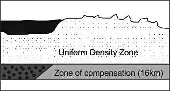
The central theme of the concept of Pratt on isostasy may be expressed as ‘uniform depth with varying density.

Key Points

  • Archdeacon Pratt calculated the gravitational force of the Himalayas from the average density of 2.75, resulting in a difference of 15.885 seconds.
  • He studied the rocks and their densities of the Himalayas and neighboring plains, finding that the density of higher parts is less than lower parts, indicating an inverse relationship between relief height and density.
  • Pratt's concept of isostasy states that a compensation level affects land density variation, with no change below it.
  • Density changes from one column to another above the compensation level, implying equal surface area must support equal mass along the compensation line.

Additional Information

  • Isostasy
    • The word Isostasy is derived from the Greek word ‘iso-stasios’ which means ‘equal standing’ (in equipoise).
    • The term isostasy was first proposed by an American geologist Clarence Dutton in 1889 to indicate the state of balance which exists between large upstanding areas of the Earth’s surface, mountain ranges and plateaus.
    • The theory says that the less dense materials of the Earth’s surface (sial) must float over the denser magma (sima) of the Earth’s interior. Similarly, as we go deep interior of the Earth’s, we see that there are several concentric layers.
    • The concept of Isostasy is extremely useful to explain ‘glacial adjustment’ taking place in Scandinavian countries after the Pleistocene great ice age.
APSET Paper 2 Mock Test - 9 (Geography) - Question 28

Which one of the following statements is correct about remote sensing?

(A) Active sensors emit their own electromagnetic energy

(B) Altimeters and scatterometers comes under the non-imaging microwave sensors category

(C) Passive sensors that measure the emitted energy

(D) LIDAR is an example of a passive remote sensor

Choose the correct answer from the options given below:
Detailed Solution for APSET Paper 2 Mock Test - 9 (Geography) - Question 28

Correct Answer: (A), (B), and (C) only.

Key Points

  • Active remote sensors create their own electromagnetic energy that, is transmitted from the sensor toward the terrain, interacts with the terrain producing a backscatter of energy, and is recorded by the remote sensor’s receiver.
  • Non-imaging microwave sensors include altimeters and scatterometers.  Generally, altimeters look straight down at the nadir below the platform and thus measure height or elevation (if the altitude of the platform is accurately known). 
  • Scatterometers are also generally non-imaging sensors and are used to make precise quantitative measurements of the amount of energy backscattered from targets. 
  • A passive sensor is a microwave instrument designed to receive and measure natural emissions produced by constituents of the Earth's surface and its atmosphere. Examples of passive sensor-based technologies include Photographic, thermal, electric field sensing, chemical, infrared and seismic. However, as can be the case with some sensors, seismic and infrared light sensors exist in both active and passive forms.
  • Lidars are active remote sensing instruments that are well suited for ABL research. They measure many important quantities, such as wind speed, aerosol backscatter and extinction, water vapor, and other trace gases, and they typically cover the entire depth of the ABL. Lidars use lasers to emit short light pulses into the atmosphere.

Additional Information

  • Lidar: A light detection and ranging sensor that uses a laser (light amplification by stimulated emission of radiation) radar to transmit a light pulse and a receiver with sensitive detectors to measure the backscattered or reflected light. Distance to the object is determined by recording the time between transmitted and backscattered pulses and by using the speed of light to calculate the distance traveled.
APSET Paper 2 Mock Test - 9 (Geography) - Question 29

Which of the following part of India receives the first monsoon in summer?

Detailed Solution for APSET Paper 2 Mock Test - 9 (Geography) - Question 29

The correct answer is the Western Ghats.

  • India receives rainfall from two monsoons:
    • South-West Monsoon
    • North-East Monsoon

  Key Points

  • South West Monsoon is a major one that occurs from July -to September.
    • The majority of Indian states receive rainfall from this Monsoon.
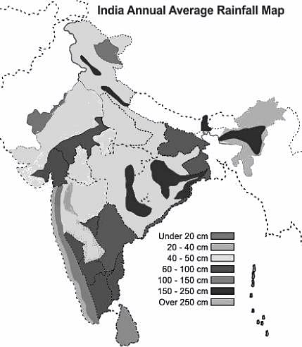
    • Rain hits first the state of Kerala and along with the coastal areas of Karnataka/Maharastra ( Konken coastal area).
    • After it gains momentum it crosses the Western ghats and causes downpours in all other states of India.


  • North-East Monsoon mostly starts at end of September.
    • This monsoon wind gets obstructed by Eastern ghats and downpours at the eastern coastal area (Coramendal Cost) along with Andhra Pradesh and Tamil Nadu.
    • The coastal area of Andhra Pradesh and the majority of Tamil Nadu receives most of the rainfall from this Monsoon.

Additional Information 

  • In- between the area of Western and Eastern ghats called Deccan Plateau (dry area) receives very little rainfall from both Monsoons. 
APSET Paper 2 Mock Test - 9 (Geography) - Question 30
Consider the following statements about Demangeon:

i. Demangeon was the pupil of Vidal de la Blache

ii. “La Picardie et les regions veisines” is his monograph

ii. He wrote L’Lomme el la Terre

iv. He was of the view that man destroyed natural flora and fauna.

Choose the correct option from below.

Detailed Solution for APSET Paper 2 Mock Test - 9 (Geography) - Question 30

Albert Damengean was a pupil of Vidal de la Blache. He produced a monograph “La Picardie et les regions veisines”. He concentrated mainly on human geography. He wrote on transport geography, population and international economics. He prepared land use maps.

Thus, the Correct answer is C.

View more questions
Information about APSET Paper 2 Mock Test - 9 (Geography) Page
In this test you can find the Exam questions for APSET Paper 2 Mock Test - 9 (Geography) solved & explained in the simplest way possible. Besides giving Questions and answers for APSET Paper 2 Mock Test - 9 (Geography), EduRev gives you an ample number of Online tests for practice

Top Courses for AP TET

Download as PDF

Top Courses for AP TET