TS TET Exam  >  TS TET Tests  >  TS SET Paper 2 Mock Test - 1 (Geography) - TS TET MCQ

TS SET Paper 2 Mock Test - 1 (Geography) - TS TET MCQ


Test Description

30 Questions MCQ Test - TS SET Paper 2 Mock Test - 1 (Geography)

TS SET Paper 2 Mock Test - 1 (Geography) for TS TET 2024 is part of TS TET preparation. The TS SET Paper 2 Mock Test - 1 (Geography) questions and answers have been prepared according to the TS TET exam syllabus.The TS SET Paper 2 Mock Test - 1 (Geography) MCQs are made for TS TET 2024 Exam. Find important definitions, questions, notes, meanings, examples, exercises, MCQs and online tests for TS SET Paper 2 Mock Test - 1 (Geography) below.
Solutions of TS SET Paper 2 Mock Test - 1 (Geography) questions in English are available as part of our course for TS TET & TS SET Paper 2 Mock Test - 1 (Geography) solutions in Hindi for TS TET course. Download more important topics, notes, lectures and mock test series for TS TET Exam by signing up for free. Attempt TS SET Paper 2 Mock Test - 1 (Geography) | 100 questions in 120 minutes | Mock test for TS TET preparation | Free important questions MCQ to study for TS TET Exam | Download free PDF with solutions
TS SET Paper 2 Mock Test - 1 (Geography) - Question 1

Consider the following statements about earthquake-

1. The point where the energy is released is called the focus of an earthquake, alternatively, it is called the epicenter.

2. The point on the surface, nearest to the focus, is called the hypocentre.

3. All-natural earthquakes take place in the lithosphere.

4. The most common ones are tectonic earthquakes. These are generated due to the sliding of rocks along a fault plane.

Which of the statements given above is/are not correct?

Detailed Solution for TS SET Paper 2 Mock Test - 1 (Geography) - Question 1

The incorrect statement is 1 and 2 only.

Key Points 

  • An earthquake is shaking or trembling of the earth’s surface, caused by the seismic waves or earthquake waves that are generated due to a sudden movement (sudden release of energy) in the earth’s crust (shallow-focus earthquakes) or upper mantle (some shallow-focus and all intermediate and deep-focus earthquakes).
  • The point where the energy is released is called the focus of an earthquake, alternatively, it is called the hypocentreHence, statement 1 is incorrect.
  • The point on the surface, nearest to the focus, is called the epicenter. Hence, statement 2 is incorrect.
  • All-natural earthquakes take place in the lithosphere. Hence, statement 3 is correct.

Additional Information

  • Types of Earthquakes:
  1. The most common ones are tectonic earthquakes. These are generated due to the sliding of rocks along a fault plane. Hence, statement 4 is correct.
  2. In the areas of intense mining activity, sometimes the roofs of underground mines collapse causing minor tremors. These are called collapse earthquakes.
  3. Ground shaking may also occur due to the explosion of chemical or nuclear devices. Such tremors are called explosion earthquakes.
  4.  A special class of tectonic earthquakes is sometimes recognised as a volcanic earthquake. However, these are confined to areas of active volcanoes.
  5. The earthquakes that occur in the areas of large reservoirs are referred to as reservoir induced earthquakes.
TS SET Paper 2 Mock Test - 1 (Geography) - Question 2

People move from rural to urban areas mainly for which of the following reasons?

(A) In search of employment

(B) In search of education

(C) In search of better health facilities

(D) In search of better accommodation

Detailed Solution for TS SET Paper 2 Mock Test - 1 (Geography) - Question 2

The correct answer is (A), (B), and (C) are correct.

Key Points

  • The correct answer is option 4, i.e., (A), (B), and (C) are correct.
  • Explanation:
    • People move from rural to urban areas primarily for better employment opportunities, better education facilities, and better health facilities.
    • -Rural areas often lack sufficient job opportunities and educational facilities, which leads people to migrate to urban areas.
    • Urban areas have better healthcare facilities, such as hospitals, clinics, and specialized doctors, which attract people seeking medical treatment.
    • Although better accommodation may also be a factor in people's decision to move to urban areas, it is not as significant as the other three factors mentioned above.

Additional Information

  • While education and employment are the primary reasons for migration to urban areas, people may also move for other reasons such as better lifestyle, social opportunities, and access to basic amenities.
  • Rural areas may also have their own unique advantages, such as lower cost of living, a closer-knit community, and a simpler lifestyle.
1 Crore+ students have signed up on EduRev. Have you? Download the App
TS SET Paper 2 Mock Test - 1 (Geography) - Question 3

The swamp forests of India are found in delta of

Detailed Solution for TS SET Paper 2 Mock Test - 1 (Geography) - Question 3

The swamp forests are found in and around deltas, estuaries and creeks. In India, they are confined to deltas of Ganga, Mahanadi, Godavari, Krishna and Cauvery. The can survive in fresh as well as brackish waters. The most prominent example is Sunderban forest in the delta of Ganga River.

TS SET Paper 2 Mock Test - 1 (Geography) - Question 4

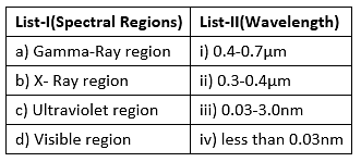
Match List-I with List-II and select the correct combination
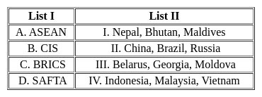

Choose the correct answer from the options given below:

Detailed Solution for TS SET Paper 2 Mock Test - 1 (Geography) - Question 4
Key Points 


Hence, the correct matching is A - IV, B - III, C - II, D - I

TS SET Paper 2 Mock Test - 1 (Geography) - Question 5

As the temperature of the black body increases,the dominant wavelength of the emitted radiation according to Wein's displacement law is:
Detailed Solution for TS SET Paper 2 Mock Test - 1 (Geography) - Question 5

According to Wein's displacement law:

Where A = Wein’s constant =2.898 x 10⁻³ mk

T = Temperature of the body

So, as the temperature of the black body increases, the dominant wavelength of the emitted radiation shifts towards shorter wavelength.

TS SET Paper 2 Mock Test - 1 (Geography) - Question 6
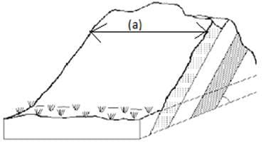
The part along with the line (a) in the following figure is

Detailed Solution for TS SET Paper 2 Mock Test - 1 (Geography) - Question 6

The direction of a horizontal line along the bedding plane is called a strike. The line (a) is a strike. The dip is the inclination of rock bed with respect to the horizontal plane. An anticline is an upfolded rock belt. The limb of the fold is the side of the fold.

TS SET Paper 2 Mock Test - 1 (Geography) - Question 7
What is known as doldrums?
Detailed Solution for TS SET Paper 2 Mock Test - 1 (Geography) - Question 7

The correct answer is Equilateral low-pressure Belts.

Important Points

  • Doldrums, also called equatorial low-pressure belts are equatorial regions of light ocean currents and winds within the intertropical convergence zone (ITCZ), a belt of converging winds and rising air encircling Earth near the Equator. Hence, option 1 is the correct answer.
  • The northeast and southeast trade winds meet there; this meeting causes air uplift and often produces clusters of convective thunderstorms. They occur along the Equator in the Indian and western Pacific oceans and slightly north of the Equator off the African and Central American west coasts. The crews of sailing ships dreaded the doldrums because their ships were often becalmed there; the designation for the resultant state of depression was apparently thus extended to these geographic regions themselves.
TS SET Paper 2 Mock Test - 1 (Geography) - Question 8
Which one of the following factors of a boundary determination between the areas of two competing firms is correct, if the gradients of delivered price and freight rate of firms' production is same?
Detailed Solution for TS SET Paper 2 Mock Test - 1 (Geography) - Question 8

Important PointsDelivered price and freight rate of firms:

  • Freight Rate, the cost of transporting goods, is reflective of a number of factors aside from normal transportation costs.
  • The main determining factors of freight rate are: mode of transportation (truck, ship, train, aircraft), weight, size, distance, points of pickup and delivery, and the actual goods being shipped
  • The prime concern of all the theories of industrial location is to find the ‘optimal location’, which is economically the best and one that gives maximum profits.
  • There has been a change in factors that distinguish earlier theories from contemporary reality: decrease in the importance of transport costs; increased organizational dynamism, interdependence, and variety, and the rise of corporate enterprise.

When the gradients of delivered price and freight rate of firms' production are the same, only distance from the location of firms can determine the boundary between the areas of two competing firms.

TS SET Paper 2 Mock Test - 1 (Geography) - Question 9

Which among the following is / are correct statements with respect to Shifting Cultivation as practiced in India?

  1. India’s largest area under shifting cultivation is in the state of Arunachal Pradesh
  2. In recent years, the cycle of shifting cultivation on a particular land has reduced drastically

Select the correct option from the codes given below:

Detailed Solution for TS SET Paper 2 Mock Test - 1 (Geography) - Question 9

The current practice of shifting cultivation in the eastern and north-eastern regions of India is an extravagant and unscientific form of land use. According to a recent estimate, India’s 0.59 percent of the total geographical area is under shifting cultivation. The effects of shifting cultivation are devastating and far-reaching in degrading the environment and ecology of these regions. The earlier 15–20 years cycle of shifting cultivation on a particular land has reduced to two or three years now. This has resulted in large-scale deforestation, soil and nutrient loss, and invasion by weeds and other species. The indigenous biodiversity has been affected to a large extent. The current statistics say that India’s largest area under shifting cultivation is in the state of Odisha.

TS SET Paper 2 Mock Test - 1 (Geography) - Question 10

A highest point in a wave is its

Detailed Solution for TS SET Paper 2 Mock Test - 1 (Geography) - Question 10

A crest is the highest point the medium rises to and a trough is the lowest point the medium sinks to. A crest is a point on the wave where the displacement of the medium is at a maximum. A point on the wave is a trough if the displacement of the medium at that point is at a minimum.

TS SET Paper 2 Mock Test - 1 (Geography) - Question 11
Consider the following statements and choose which amongst them is true:

i. Sunspots are features on the solar surface which appears as dark spot

ii. Sunspots are huge magnetic storms that occur on sun’s surface.

Choose the correct options:

Detailed Solution for TS SET Paper 2 Mock Test - 1 (Geography) - Question 11

Sunspots are the most conspicuous feature on the solar surface which appears as dark spots. The sunspots are simply the huge magnetic storms that occur on the sun’s surface. The number of sunspots increases and decreases in a cyclic manner.

Thus, the Correct answer is C.

TS SET Paper 2 Mock Test - 1 (Geography) - Question 12
Which one from the followings is NOT an effect of El-Nino? 
Detailed Solution for TS SET Paper 2 Mock Test - 1 (Geography) - Question 12

The correct answer is It lowers down the temperature of water on the Peruvian coast.

Key Points

  • El Niño is a climate pattern that affects atmospheric circulation and temperatures in the Pacific Ocean, with wide-ranging impacts on global weather and ocean conditions. 
  • El Niño distorts equatorial atmospheric circulation. This can cause significant alterations in weather patterns around the world.
  • El Niño can cause irregularities in the evaporation of sea water. It mainly changes the pattern of rainfall across the Pacific and Indian Oceans, which could lead to changes in evaporative patterns.
  • El Niño reduces the number of fish in the sea. As it disturbs water temperature and nutrient availability, El Niño could affect food chains and cause a decline in fish populations, particularly in the Eastern Pacific.
  • But, El Niño does not lower the temperature of the water on the Peruvian coast. In fact, El Niño conditions are characterized by unusually warm ocean temperatures in the Equatorial Pacific, including along the Peruvian coast, not cooler temperatures.

Additional Information

  • The term El Niño means "The Little Boy" or "Christ Child" in Spanish.
  • It was originally used by fishermen along the coasts of Ecuador and Peru to refer to the unusually warm waters that reduced their fish catches.
  • Today, El Niño refers to the broad-scale warming of the equatorial Pacific that takes place every 2-7 years and lasts between six to 18 months.
TS SET Paper 2 Mock Test - 1 (Geography) - Question 13

Assertion A): The ecosystem surrounding a river gets damaged due to construction of a dam.

Reason R): The area gets inundated with large volume of water.

Choose the correct code:

Detailed Solution for TS SET Paper 2 Mock Test - 1 (Geography) - Question 13

Assertion and reasoning-type questions have one assertion (A) and one reason (R). We must first determine whether the statement is true. If the statement is true, we must next determine whether the reason correctly explains the assertion.

The example of a fish in a stream makes it quite clear that if we want to understand the living things and their place in nature properly, we must not consider them alone, but rather as a part of an interacting system. Such an interacting system, e.g., a stream is called ecosystem. You must have seen a lake, a pond; a grassland, or a forest at one time or another. All these are some more examples of the ecosystem.

While there are direct impacts on environment-related with the construction of the dam, for example, dust, erosion, borrow, and disposal problems. The greatest impacts result from the impoundment of water, flooding of land to form the dam, and alteration of water flow downstream. It affects the ecosystem as a whole.

The assertion is true.

Effects of dam:

  • Dams can displace a large number of people. .
  • Reservoirs behind a dam can lead to greenhouse gas emissions. ...
  • This technology hampers local ecosystems.
  • Some river sediment is useful
  • Dams create a risk of the flood if they experience a failure.
  • It provides water storage facility
  • The whole area gets overwhelmed with water
  • It helps farmers in irrigation
  • Electricity generation.

​The reason is true.

By referring to the above explanation we came to know that both the assertion and reason are true but Reason was not the correct explanation of the assertion.

TS SET Paper 2 Mock Test - 1 (Geography) - Question 14

Match the List-I with List-II two.

Choose the correct answer form the code given below:

Detailed Solution for TS SET Paper 2 Mock Test - 1 (Geography) - Question 14

In remote sensing technique, the electromagnetic radiation emitted or reflected from the objects must pass through atmosphere before it is detected by the remote sensor. Remote sensing by satellite involve atmospheric degradation. Hence the atmospheric conditions determine the effective use of electromagnetic spectrum for remote sensing.

  • Wavelength of visible region is 0.4-0.7µm.
  • Wavelength of ultraviolet region is 0.3 to 4µm.
  • Wavelength of X ray region is 0.03to 3.0 nm.
  • Wavelength of gamma ray region is less than 0.03nm.

Thus, the Correct answer is A.

TS SET Paper 2 Mock Test - 1 (Geography) - Question 15

Assertion A): Mapping of landslide prone areas and construction of houses, felling of trees and grazing in landslide prone areas should be prohibited.

Reason R): Afforestation in the vulnerable areas is an effective way of durable landslides control.

Detailed Solution for TS SET Paper 2 Mock Test - 1 (Geography) - Question 15

The correct answer is Both A and R are correct and R is not the correct explanation of A.

Key Points

Assertion and reasoning-type questions have one assertion (A) and one reason (R). We must first determine whether the statement is true. If the statement is true, we must next determine whether the reason correctly explains the assertion.

First, we will consider the statement of Assertion.

  • A landslide is the movement of rock, earth, or debris down a sloped section of land. Landslides are caused by rain, earthquakes, volcanoes, or other factors that make the slope unstable. 
  • Human activity, such as agriculture and construction, can increase the risk of a landslide. Irrigation, deforestation, excavation, and water leakage are some of the common activities that can help destabilize, or weaken, a slope.
  • Grazing by domesticated sheep and goats can also alter rates and trajectories of landslide succession.
  • Conversion from trees to crops or grazing land significantly reduces rooting depth and strength of the soil. It means that soils are dried to a lesser depth and degree due to shallower rooting patterns and lower levels of transpiration.
  • Hence, construction of houses, felling of trees, and grazing in landslide prone areas should be prohibited.

Hence, the statement provided in the assertion is true.

Now we will consider the statement of Reason.

  • Given these impacts, maintenance of forest cover and afforestation in the vulnerable areas is an effective way of durable landslides control.
  • Scientific studies also confirm the crucial role of trees and forests in preventing landslides, not only by reinforcing and drying soils but also indirectly obstructing smaller slides and rockfalls.
  • Deep-rooted trees and shrubs can reduce the occurrence of shallow rapidly moving landslides by strengthening soil layers and improving drainage.
  • Transpiration via extensive root systems also reduces soil water content and landslide risk. Additionally, forests can play a role in attenuating and blocking smaller debris flows and rockfalls by forming a physical barrier.

Hence, the statement given as reason is correct. But it is not the correct reason (explanation) supporting the assertion.

TS SET Paper 2 Mock Test - 1 (Geography) - Question 16
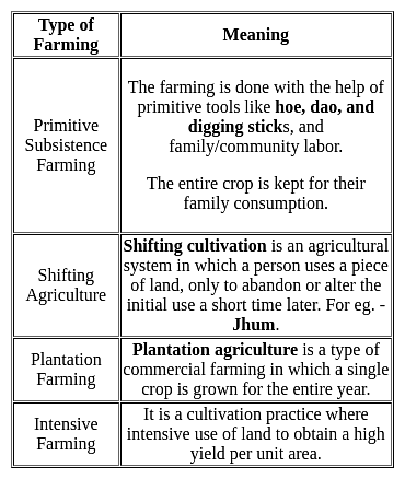
What is "Jhoom"?
Detailed Solution for TS SET Paper 2 Mock Test - 1 (Geography) - Question 16

The correct answer is A form of agriculture.

Key Points

  • "Jhoom" is a form of agriculture.
  • In this agriculture farming method, the trees and other vegetation that are present on a particular land are cut down to create the field for crop cultivation.
  • "Jhoom" is one of the oldest practices of agriculture systems.
  • Jhoom farming is also known as 'slash and burn agriculture or 'fire-fallow cultivation.
  • It is mostly practiced by the tribal groups in the northeastern states of India like Arunachal Pradesh, Meghalaya, Mizoram, and Nagaland and also in the districts of Bangladesh like Khagrachari and Sylhet.

Additional Information

TS SET Paper 2 Mock Test - 1 (Geography) - Question 17

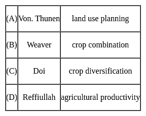
The following pairs are given about the contribution of geographer's in Agricultural geography and find out which is not correct?
Detailed Solution for TS SET Paper 2 Mock Test - 1 (Geography) - Question 17

The correct answer is D.

Key Points

  • Von Thunen conceived the idea of a land-use model in both urban and rural landscapes around a city on an isotropic landscape. His idea is basically how economic rent decreases from the center of a city to its periphery. His system of land use around a city with no trade alliance with any other country is ring-shaped.
  • In the field of agricultural geography, Weaver (1954) was the first to use statistical techniques for the demarcation of crop combination regions of the Middle West (USA). In his attempt to demarcate the agricultural regions of the Middle West (USA), Weaver based his analysis on acreage statistics.
  • Crop diversification refers to the addition of new crops or cropping systems to agricultural production on a particular farm taking into account the different returns from value-added crops with complementary marketing opportunities. Crop diversification is a concept that is opposite to crop specialization. Farmers all over the world, especially in developing countries, try to grow several crops in their holdings in an agricultural year. For the measurement of crop diversification, Doi and Bhatia (1965) developed a formula based on the gross cropped area.
  • There are several ways to measure crop diversification, and the most important include Herfindahl Index, Simpson Diversity Index, Ogive Index, Margalef Index, Shannon Index, Berger-Parker Index, and Entropy Index.
  • Jasbir Singh has proposed a unique method for the measurement of Agricultural Productivity which is in terms of monetary value earned from agriculture per capital-labor employed.
  • He proposed that agricultural productivity is the summation of the product of the output of production of the crop and its market price, from which the cost of production is subtracted. Agricultural Productivity= ∑( Pij*Mij)-Cop- Here P is output or production in quantity of the crop, M is the Market price and Cop is the cost of Production.
TS SET Paper 2 Mock Test - 1 (Geography) - Question 18
Match the scholars (List-I) with the book/theory/concept/model (List-II) they propounded.

Detailed Solution for TS SET Paper 2 Mock Test - 1 (Geography) - Question 18

Andre G. Frank is a German-American scholar who promoted the dependency theory by his famous work “the development of the underdevelopment”. In 1974, in his book ‘The Modern World System’, Wallerstein gave the world system theory. In his paper ‘The stages of Economic Growth’ in 1959, W.W. Rostow gave the modernization theory based on the historical stages of economic growth. John Friedmann has given the concept of core-periphery in his book “Regional Development policy: A case study of Venezuela” in the year 1966.

TS SET Paper 2 Mock Test - 1 (Geography) - Question 19

According to the data, released by housing and urban poverity alleviation ministry, which state has the maximum number of slums?

Detailed Solution for TS SET Paper 2 Mock Test - 1 (Geography) - Question 19

According to Census 2011, Maharashtra has highest number of slum blocks in the Country. According to ministry reports out of 1 lakh slum blocks 21,000 lies in Maharashtra.

TS SET Paper 2 Mock Test - 1 (Geography) - Question 20
India is the leading producer of which of the following crop?
Detailed Solution for TS SET Paper 2 Mock Test - 1 (Geography) - Question 20

 India ranks second in production of rice and wheat in world, after China. India holds third rank in world production of cotton. India has the largest area under Sesamum cultivation in world and is also the largest producer of the same, making for nearly one-third of the total produce of the oilseed in world.

Thus, the correct answer is C.

TS SET Paper 2 Mock Test - 1 (Geography) - Question 21
Natural change and ______ are the two factors that affect population change for a particular area.
Detailed Solution for TS SET Paper 2 Mock Test - 1 (Geography) - Question 21

Three primary factors account for population change, or how much a population is increasing or decreasing. These factors are birth rate, death rate, and migration.

  • Births and deaths are natural causes of population change. The difference between the birth rate and the death rate of a country or place is called the natural increase. The natural increase is calculated by subtracting the death rate from the birth rate.

Key Points

  • Human migration involves the movement of people from one place to another with intention of settling, permanently or temporarily, at a new location.

Additional Information

  • Zero population growth refers to a population that is unchanging – it is neither growing nor declining; the growth rate is zero.
  • Immigration is the international movement of people to a destination country of which they are not natives or where they do not possess citizenship in order to settle as permanent residents or naturalized citizens.

Natural change and Migration are the two factors that affect population change for a particular area. Therefore Option 4 is the correct answer.

TS SET Paper 2 Mock Test - 1 (Geography) - Question 22
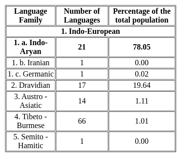
Which one of the following is the largest linguistic group of India?
Detailed Solution for TS SET Paper 2 Mock Test - 1 (Geography) - Question 22

The correct answer is Indo-Aryan.

Key Points

  • As per the Linguistic survey report of the 2011 census,
  • Hence. option 3 is correct.
TS SET Paper 2 Mock Test - 1 (Geography) - Question 23
What is the median of the values 11, 7, 6, 9, 12, 15, 19 ?
Detailed Solution for TS SET Paper 2 Mock Test - 1 (Geography) - Question 23

Calculation:

Data in ascending order = 6, 7, 9, 11, 12, 15, 19

Since, n = 7 (odd)

Hence,

Median =

= 4th term = 11

∴ The median of the values is 11.

TS SET Paper 2 Mock Test - 1 (Geography) - Question 24
Consider the following statements:-

a) Potholes and Plunge pools are found in the upper course of the river.

b) During the formation of meanders, the river does the erosional work on the convex bank and the depositional work on the concave bank.

c) A large number of tributaries joining the main river also lead to the formation of Deltas.

d) Braided stream is that which gets divided into several networks due to excess deposits on the river plain.

Which of the following statements are correct?

Detailed Solution for TS SET Paper 2 Mock Test - 1 (Geography) - Question 24

A river follows a curved path. As a result, the speed of the river water slows down and the river does both the works of erosion and deposition. However, when the river starts to bend and swing in large curves, it does the erosional work on the concave bank of the river while deposition is done on the convex bank. This happens because the speed of the river water is more on the concave bank and less on the convex bank. This thing gradually increases and forms an S shape.

A large number of tributaries joining the main river are required for the formation of deltas as large amount of additional sediments are necessary. The more the number of steams, the more will the deposition of sediments which will consequently lead to delta formation.

TS SET Paper 2 Mock Test - 1 (Geography) - Question 25

Which of the following statement is not correct about andesitic or acidic lava?

Detailed Solution for TS SET Paper 2 Mock Test - 1 (Geography) - Question 25

The correct answer is They are dark coloured basalt, rich in iron and magnesium but poor in silica

Important Points

  • ACIDIC: Magma is composed of molten rock and is stored in the Earth’s crust. Lava is magma that reaches the surface through a volcano vent.
    • These lavas are highly viscous with a high melting point.
    • They are light-colored, of low density, and have a high percentage of silica.
    • They flow slowly and seldom travel far before solidifying.
    • The resultant volcanic cone is therefore stratified (hence the name stratovolcano) and steep-sided.
    • Andesitic lava flow occurs mostly along the destructive boundaries (convergent boundaries).
  • BASIC: These are the hottest lavas, about 1,000 °C, and are highly fluid.
    • They are dark coloured basalt, rich in iron and magnesium but poor in silica.
    • They flow out of volcanic vent quietly and are not very explosive.
    • Due to their high fluidity, they flow readily with a speed of 10 to 30 miles per hour.
    • They affect extensive areas, spreading out as thin sheets over great distances before they solidify.
    • The resultant volcano is gently sloping with a wide diameter and forms a flattened shield or dome.
    • Shield type lava flow is common along the constructive boundaries (divergent boundary).
TS SET Paper 2 Mock Test - 1 (Geography) - Question 26
Mode>Median>Mean implies what kind of distribution?
Detailed Solution for TS SET Paper 2 Mock Test - 1 (Geography) - Question 26

The above condition implies negatively skewed distribution with its tail on the left side of the frequency curve. Skewness refers to the extent of asymmetry in the shape of the frequency distribution curve. Any asymmetry distribution is a skewed distribution. Basically, it measures the extent by which the bulk of the values in a distribution are concentrated on one or the other side of the mean.

TS SET Paper 2 Mock Test - 1 (Geography) - Question 27
Which of the following are evidences of Continent Drift Theory?
Detailed Solution for TS SET Paper 2 Mock Test - 1 (Geography) - Question 27

The correct answer is All of the Above.

Key Points

Evidence that supports the theory:

  • The Matching of Continents (Jig-Saw-Fit): 
    • The shorelines of Africa and South America facing each other match remarkably.
  • Rocks of Same Age Across the Oceans: 
    • Radiometric dating methods have correlated the rock formation in different continents.
  • Tillite: 
    • The glacial tillite found in the Gondwana system of sediments has its resemblance to six different landmasses of the Southern Hemisphere.
  • Placer Deposits: 
    • The placer deposits of gold in the Ghana coast do not have source rock in the region. 
    • The gold deposits of Ghana have been derived from the Brazil plateau when the two continents lay side by side
  • Distribution of Fossils: 
    • Identical species of plants and animals adapted to living on land or in freshwater are found on either side of the marine barriers.

Important Points

Continental Drift Theory:

  • Alfred Wegener put forward a continental drift theory in 1912.  
  • All the continents are formed of a single Continental mass and a mega ocean surrounded the same.
  • The supercontinent was named Pangaea and the Mega Ocean was called Panthalassa.  
  • Pangea first broke into two large Continental masses Laurasia and  Gondwanaland Forming the northern and Southern components respectively. 
  • Laurasia and Gondwanaland continued to break into smaller continents that existed today.  ​
TS SET Paper 2 Mock Test - 1 (Geography) - Question 28
Which of the following is the correct sequence of the Core Periphery Model as given by Friedman ?
Detailed Solution for TS SET Paper 2 Mock Test - 1 (Geography) - Question 28

Important Points

The conventional core-periphery model of development tries to represent the emergence of a regional urban system in four major stages which goes on par with the development of regional transport systems. From an initial process that favors the setting of spatial inequalities, these are eventually reduced and a functionally integrated urban system emerges.

Stage 1 (Pre-industrial): Localized Economics

  • The pre-industrial (agricultural) society, with localized economies and a small-scale settlement structure.
  • Each settlement is fairly isolated, activities are dispersed and mobility is low.
  • There are limited differences between spatial entities in terms of levels of economic development.

Stage 2 (Transitional): Core-periphery

  • The concentration of the economy in the core city begins as a result of innovation, capital accumulation, and industrial growth.
  • The specific reasons behind this concentration are often not too clear, location (better access) being a significant factor, but the fact remains that a dominant center emerges within an urban system to become its growth pole.
  • Trade and mobility increase, but within a pattern dominated by the core even if the overall mobility remained low.
  • Among the numerous examples of such a phase are the early industrialization of Great Britain in the late 18th century or the beginning of the colonial incorporation of Latin America, Africa, or Asia.

Stage 3 (Industrial): dispersion of economic activity

  • Through a process of economic growth and diffusion, other growth centers emerge.
  • The main reasons for deconcentration are increasing input costs (mainly labor and land) in the core area.
  • This diffusion is linked with increased interactions between elements of the urban system and the construction of transport infrastructures.

Stage 4 (Post-industrial): spatial integration

  • The urban system becomes fully integrated and spatial inequalities are reduced significantly.
  • The distribution of economic activities creates a specialization and a division of labor linked with intense flows along high-capacity transport corridors.
  • The factors that have favored spatial inequalities in the previous phases of development have structured dominant poles of the urban system and favored the setting of a large commercial gateway, usually a world city.

Hence, the correct sequence is Localized economies, core-periphery, dispersion of economic activity, spatial integration

TS SET Paper 2 Mock Test - 1 (Geography) - Question 29
What do large scale maps show?
Detailed Solution for TS SET Paper 2 Mock Test - 1 (Geography) - Question 29

The correct answer is Villages and town localities.
Important Points

Large scale maps show a relatively small area with a great amount of detail. They are typically used in topographic, cadastral, city planning, and detailed engineering surveys. Therefore, among the options provided:

  1. Villages and town localities are typically shown in large scale maps, as these maps can display detailed features of a small area.

The other options:

  1. States and countries
  2. Continents and oceans
  3. Climatic regions of the world

are typically shown in small scale maps, which cover a large area with less detail.

So, the correct answer is:

  1. Villages and town localitie
TS SET Paper 2 Mock Test - 1 (Geography) - Question 30

Consider the following statements:

1. India's first solar-wind hybrid plant is located in Maharashtra.

2. Diu is the first solar-powered island in India.

3. India's first village to be powered by solar all day is located in Gujarat.

Which of the statements given above are correct?

Detailed Solution for TS SET Paper 2 Mock Test - 1 (Geography) - Question 30

The correct answer is 2 and 3.Key PointsSolar Power:

  • India ranks 3rd in the renewable energy country according to Attractiveness Index’ in 2021.
  • It is the 3rd largest energy-consuming country in the world.
  • India stands 4th globally in Renewable Energy Installed Capacity (including Large Hydro).
  • It ranks 4th in Wind Power capacity & 4th in Solar Power capacity (REN21 Renewables 2022 Global Status Report).
  • India's first wind and solar hybrid power generating plant is located in Jaisalmer, Rajasthan. Hence, statement 1 is incorrect.
  • The hybrid power plant unlocks the full potential of renewable energy.
  • It eliminates generation intermittency and provides a more stable alternative to meet rising power demand.
  • The union territory of "Diu" is India's first solar-powered island. Hence, statement 2 is correct.
  • Diu generates a total of 13 MW of electricity from solar power on a daily basis.
  • Modhera in Gujarat state is India's first village to run entirely on solar power. Hence, statement 3 is correct.
  • The solar project not only reduces the villages' energy bills, but it is also becoming a source of revenue.
View more questions
Information about TS SET Paper 2 Mock Test - 1 (Geography) Page
In this test you can find the Exam questions for TS SET Paper 2 Mock Test - 1 (Geography) solved & explained in the simplest way possible. Besides giving Questions and answers for TS SET Paper 2 Mock Test - 1 (Geography), EduRev gives you an ample number of Online tests for practice

Top Courses for TS TET

Download as PDF

Top Courses for TS TET