TS TET Exam  >  TS TET Tests  >  TS SET Paper 2 Mock Test - 2 (Geography) - TS TET MCQ

TS SET Paper 2 Mock Test - 2 (Geography) - TS TET MCQ


Test Description

30 Questions MCQ Test - TS SET Paper 2 Mock Test - 2 (Geography)

TS SET Paper 2 Mock Test - 2 (Geography) for TS TET 2024 is part of TS TET preparation. The TS SET Paper 2 Mock Test - 2 (Geography) questions and answers have been prepared according to the TS TET exam syllabus.The TS SET Paper 2 Mock Test - 2 (Geography) MCQs are made for TS TET 2024 Exam. Find important definitions, questions, notes, meanings, examples, exercises, MCQs and online tests for TS SET Paper 2 Mock Test - 2 (Geography) below.
Solutions of TS SET Paper 2 Mock Test - 2 (Geography) questions in English are available as part of our course for TS TET & TS SET Paper 2 Mock Test - 2 (Geography) solutions in Hindi for TS TET course. Download more important topics, notes, lectures and mock test series for TS TET Exam by signing up for free. Attempt TS SET Paper 2 Mock Test - 2 (Geography) | 100 questions in 120 minutes | Mock test for TS TET preparation | Free important questions MCQ to study for TS TET Exam | Download free PDF with solutions
TS SET Paper 2 Mock Test - 2 (Geography) - Question 1

Major constituent gasses of the atmosphere are _____________.

Detailed Solution for TS SET Paper 2 Mock Test - 2 (Geography) - Question 1

Atmosphere: The earth is surrounded by a layer of gas called the atmosphere. This thin blanket of air is an integral and important aspect of the planet.

Key-Points

Gaseous composition of the atmosphere:

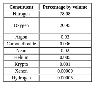
  • The air in the atmosphere is a mixture of many gases like nitrogenoxygen, carbon dioxide, and water vapors.
  • The atmosphere is composed mainly of nitrogen and oxygen
  • Nitrogen and oxygen are two gases that make up the bulk of the atmosphere.
  • Carbon dioxide, helium, ozone, argon, and hydrogen are found in lesser quantities.
  • Nitrogen is the most plentiful gas in the air. It comprises 78% of the total composition of air.
  • Oxygen holding the second position by volume constitutes 21% of the atmosphere.

Hence, option 2 is the correct answer.

Important Point

TS SET Paper 2 Mock Test - 2 (Geography) - Question 2

The thickness of the Troposphere is maximum at the Equator during which of the following seasons?

Detailed Solution for TS SET Paper 2 Mock Test - 2 (Geography) - Question 2

The correct answer is Summer.

Key Points

  • The Troposphere is the lowest layer of the atmosphere.
  • It extends up to an height of 20 km.
  • The height of the Troposphere varies from the equator to the poles.
  • its height varies with latitude and seasons.
  • Its height is lower in the winter and highest in the summer.
  • It can be as high as 20 km near the Equator and as low as 7 km at the poles.
  • Therefore, the thickness of the Troposphere is maximum at the Equator during summer season.

 Thus, we can say that the thickness of the Troposphere is maximum at the Equator.

1 Crore+ students have signed up on EduRev. Have you? Download the App
TS SET Paper 2 Mock Test - 2 (Geography) - Question 3

Consider the following statements regarding Census-2011:

1. The percentage decadal growth of population during 2001-2011 has registered the sharpest decline since independence.

2. It created the National Population Register (NPR) which will build up a comprehensive identity database of usual residents of the country.

3. Census 2011 was conducted in two phases - the house listing phase and the population enumeration phase.

Which of the above statements is/are correct?

Detailed Solution for TS SET Paper 2 Mock Test - 2 (Geography) - Question 3
  • Census 2011 was conducted in two phases:
  1. The first phase, called the House Listing or Housing Census was conducted between April and September, 2010 across the country, depending on the convenience of different States/UTs.
  2. The second phase, called the Population Enumeration, began simultaneously all over the country from February 9, 2011 and continued up to February 28, 2011.
  • The landmark of Census 2011 is the creation of the National Population Register (NPR) which will build up a comprehensive identity database of usual residents of the country. It will have the biometric data and Unique Identification (UID) number of every person (15 years and above).
  • National Identity Cards will be given in a phased manner to all usual residents by the Office of the Registrar General and Census Commissioner, India.
  • India's population as on 1 March 2011 stood at 1,210,193,422 (623.7 million males and 586.4 million females) in comparison to a total of 1, 028, 737, 436 in the year 2001. In absolute terms, the population of India has increased by more than 181 million during the decade 2001-2011.
  • The percentage decadal growth of population during 2001-2011 has registered the sharpest decline since independence. It declined from 23.87 per cent for 1981-1991 to 21. 54 per cent for the period 1991-2001, a decrease of 2.33 per cent. For 2001-2011, decadal growth has become 17.64 per cent, a further decrease of 3.90 percentage point.
TS SET Paper 2 Mock Test - 2 (Geography) - Question 4

What among the following is essential for the sustained quality of life and global peace?

Detailed Solution for TS SET Paper 2 Mock Test - 2 (Geography) - Question 4

Natural resources of the Earth must be distributed among the people uniformly so that each and everyone gets his share of the resource. Human greed, corruption, and the lobby of the rich and powerful are the forces working against an equitable distribution of resources.

Key Points

Equitable distribution of resources:

  • Equitable distribution of resources provides equal rights to all sections of society (rich and poor) to access these resources.
  • It makes sure that everyone has the essential elements for life (such as food, water, shelter, etc.).
  • It prevents the division of society and the accumulation of resources in the hands of a few persons.
  • It helps to maintain the continuous flow of resources so that everyone can get their share.
  • It is essential for the sustained quality of life and global peace.

The forces that work against equitable distribution include:

  • The regional distribution of resources (such as soil and minerals).
  • Corruption and greed of some humans
  • Uneven distribution of resources between the rich and the poor.

Hence, option 4 is the correct answer.

TS SET Paper 2 Mock Test - 2 (Geography) - Question 5

What is remote sensing image interpretation? Choose the correct option.

Detailed Solution for TS SET Paper 2 Mock Test - 2 (Geography) - Question 5

Key Points

Remote sensing image interpretation

  • ​Remote sensing image interpretation is a valuable tool for a variety of applications.
  • It can be used to monitor changes in the environment, identify areas of environmental concern, and plan for future development. 
  •  The process of analyzing satellite images to identify patterns and features on the Earth's surface. This information can be used for a variety of purposes, including land use planning, environmental monitoring, and natural resource management.
  • Remote sensing images are collected by satellites that orbit the Earth. These satellites are equipped with sensors that can detect different types of electromagnetic radiation, including visible light, infrared radiation, and microwave radiation.
  • The data collected by these sensors is then processed and converted into images that can be interpreted by humans.
  • Image interpretation is a complex process that requires specialized training and knowledge. Interpreters must be able to identify the different features in an image and understand how they relate to the real world. They must also be able to use this information to draw conclusions about the landscape.

Additional Information

The process of analyzing soil samples to determine their composition: 

  • Soil sampling and analysis is a common method for assessing soil quality and fertility.
  • Soil samples are collected from different depths and locations in a field or other area of interest. The samples are then analyzed in a laboratory to determine their chemical and physical properties, such as pH, nutrient content, and texture.
  • This information can be used to make recommendations for fertilizer application, irrigation, and other management practices.

The process of analyzing water samples to determine their purity: 

  • Water quality testing is the analysis of physical, chemical, and biological characteristics of water.
  • Water samples are collected from various sources, such as rivers, lakes, streams, and groundwater wells. The samples are then analyzed in a laboratory to determine the presence of contaminants, such as bacteria, heavy metals, and pesticides.
  • This information can be used to assess the safety of drinking water and to identify sources of pollution.

The process of analyzing air samples to determine their pollution level: 

  • Air quality monitoring is the process of measuring the levels of pollutants in the air.
  • Air samples are collected from various locations, both indoors and outdoors. The samples are then analyzed in a laboratory to determine the presence of pollutants, such as particulate matter, ozone, and nitrogen dioxide.
  • This information can be used to assess the health risks associated with air pollution and to develop strategies to reduce air pollution.
TS SET Paper 2 Mock Test - 2 (Geography) - Question 6
Which of the following statements BEST reflects the overall view on these geostrategic theories?
Detailed Solution for TS SET Paper 2 Mock Test - 2 (Geography) - Question 6

Answer: option 3.

The Heartland and Rimland theories have been seminal in the study of geopolitics, offering frameworks for understanding global power dynamics through geographical lenses. While each theory has its critics and limitations, especially in the context of contemporary technological and geopolitical developments, they continue to provide foundational perspectives for analyzing international relations.
Key Points
The Heartland and Rimland theories provide valuable but contrasting insights:
  • Both theories approach the concept of global dominance from different geographical standpoints, with the Heartland Theory focusing on the central Eurasian landmass and the Rimland Theory emphasizing the strategic importance of coastal areas.
  • Despite criticisms and evolving global contexts, both theories contribute to a more nuanced understanding of the interplay between geography and power.
  • They offer contrasting yet complementary perspectives, encouraging analysts to consider a broader range of factors when assessing geostrategic dynamics.
Additional Information
Both theories are completely outdated and have no relevance in the modern world:
  • This statement dismisses the foundational insights provided by both theories into the significance of geography in global politics.
  • While technological advancements and new geopolitical challenges may have altered the landscape since these theories were first proposed, the core idea that geography matters in international relations remains relevant.
  • Moreover, elements of these theories continue to inform strategic thinking and policy-making in various contexts.
The Rimland Theory offers a more accurate perspective than the Heartland Theory:
  • Declaring one theory as more universally accurate than the other oversimplifies the complexity of geopolitics.
  • Each theory provides perspectives that are valuable in different contexts, and their relevance can vary depending on the specific geopolitical situation being analyzed.
  • It is more productive to view them as complementary rather than in competition for accuracy.
The theories are useful for historical analysis but offer limited predictive power:
  • While it's true that the predictive power of these theories may be limited, especially in light of modern technological and international developments, this statement underestimates the continuing impact of geography on geopolitical strategies and decisions.
  • These theories are not only useful for understanding past geopolitical strategies but also for framing current issues in a broader geographical context.
  • The insight that geography plays a critical role in international relations remains pertinent.

Hence, option 3.The Heartland and Rimland theories provide valuable but contrasting insights is correct.

TS SET Paper 2 Mock Test - 2 (Geography) - Question 7
Cloudy nights are warmer than clear nights because
Detailed Solution for TS SET Paper 2 Mock Test - 2 (Geography) - Question 7

The correct answer is it acts as a hindrance to terrestrial radiation.

Key Points

  • Cloudy nights are warmer compared to clear cloudless nights, because clouds Reflect back the heat given off by earth.
  • The cloudy skies are like a blanket and the warmer air on the ground with us tries to leave and the clouds stop it from leaving.
  • Warmer air will always try to move up and it cannot do so because of the clouds. That's why you might notice that cloudy nights are warmer than clear nights.
  • If skies are clear, heat emitted from the earth\'s surface freely escapes into space, resulting in colder temperatures.
TS SET Paper 2 Mock Test - 2 (Geography) - Question 8
Match List-I with List-II

Code:

Detailed Solution for TS SET Paper 2 Mock Test - 2 (Geography) - Question 8

  • 21st March is the day of equinox. The sun is directly above the equator. The equinox also occurs on 23rd September. The day and night last12 hours each on these days.
  • 1st June is the day that is expected arrival of monsoon in India. Though this just expected date, usually monsoon arrives later.
  • 22nd Dec is winter solstice. This is supposed to be the longest night. On this day, the sun is overhead at the tropic of Capricorn.
  • 21st June the day of longest summer solstice. The sun is overhead the tropic of cancer on the day of summer solstice.

Thus, the correct answer is A.

TS SET Paper 2 Mock Test - 2 (Geography) - Question 9

Directions: The question consists of two statements, an assertion and a reason. The student must first determine whether each statement is true. Each question below consists of an assertion and a reason.

Assertion (A): Tigers are an endangered species.

Reason(R): Tigers are being poached by humans.

Detailed Solution for TS SET Paper 2 Mock Test - 2 (Geography) - Question 9

Assertion and reasoning type questions have one assertion (A) and one reason (R). We must first determine whether the statement is true. If the statement is true, we must next determine whether the reason correctly explains the assertion.

First, we will consider the statement of Assertion.

Tigers are globally listed as an endangered species as per the government of India and various international organizations such as the IUCN Red List of threatened species.  

Hence, the statement provided in the assertion is true.

Now we will consider the statement of Reason.

The main threat these big cats are facing is from humans only. Wild tigers are hunted to meet the demands of the $20 billion a year illegal wildlife market.

Hence, the statement provided in the reason is correct.

Conclusion- We can say the statement of Assertion and Reason are true and (R) is the correct explanation of (A)

TS SET Paper 2 Mock Test - 2 (Geography) - Question 10
Which one of the following in the correct sequence of economic integration between countries?
Detailed Solution for TS SET Paper 2 Mock Test - 2 (Geography) - Question 10

The Preferential Trade Area is the first step in economic integration. It gives preferred access regarding certain commodities to the participating countries. Free Trade Area is the second step gives reduced tariffs and lessened trade barriers which increases trade of goods and services. Customs Union is the next step after Free Trade area. It has common external tariff. It is designed to end re-exportation. A common market with a customs union forms an economic union. It is 6th stage in economic integration.

Thus, the correct answer is C.

TS SET Paper 2 Mock Test - 2 (Geography) - Question 11
The Concentric circle theory of city morphology was developed by:
Detailed Solution for TS SET Paper 2 Mock Test - 2 (Geography) - Question 11

The correct answer is E. Burgess.
Important Points
Concentric circle theory

  • The Concentric Circle Theory of city morphology was developed by sociologist E. Burgess in 1925.
  • Burgess was interested in studying the social organization of cities, particularly the ways in which different social groups interacted with each other in urban areas.

According to Burgess, cities grow in a series of concentric circles, with each circle representing a different type of land use and social group.

  • The innermost circle is the central business district (CBD), which is the economic and commercial hub of the city. Surrounding the CBD is the zone of transition, which is a mixed-use area characterized by industrial and residential land uses.
  • Burgess argued that this area was often home to marginalized and transient populations, including recent immigrants, the working poor, and the homeless.

The next concentric circle is the zone of working-class homes,

  • which is a predominantly residential area characterized by low-income housing and blue-collar workers. Beyond this is the zone of better residences, which is a middle-class residential area characterized by single-family homes and a higher standard of living.

Finally, the outermost concentric circle is the commuter zone, which is a suburban area where people live who commute to the central city for work.

Burgess believed that this pattern of concentric circles was universal and could be observed in cities around the world. He argued that the concentric circle model reflected the natural tendency of social groups to sort themselves based on their socio-economic status and land use needs.

In conclusion, the Concentric Circle Theory of city morphology was developed by E. Burgess and proposes that cities grow in a series of concentric circles, each with a different type of land use and social group. The innermost circle is the CBD, followed by the zone of transition, zone of working-class homes, zone of better residences, and finally the commuter zone.

TS SET Paper 2 Mock Test - 2 (Geography) - Question 12

A tourist in Mumbai observes high tide near Gateway of India at 7.00 AM. At what time, he should expect another high tide on the same day?

Detailed Solution for TS SET Paper 2 Mock Test - 2 (Geography) - Question 12

Most coastal areas experience two high and two low tides per day. One of these high tides is at the point on the earth which is closest to the moon (sub lunar) and other high tide is at the opposite point on the earth (antipodal). One tidal cycle comprises two high tides and two low tides. One tidal cycle completes in 24 hours and 50.4 minutes. This is because of the revolution of Moon around the earth and both earth’s rotation and moon revolution are in same direction. (Moon is not stationary, so there is a difference, if moon were stationary the high tides would have occurred exactly in 12 hours). The high tides occur at an interval of 12 hours and 25.2 minutes. This means that if there is a high tide is at 7.00 am, next high tide would be at 7.25 pm and next would be at 7.50 am, and so on. The time difference between two high tides is called “Tidal Interval”. The tidal cycle in this pattern is called semidiurnal. However, most of the enclosed water bodies or away from the open ocean such as Caribbean Sea or Caspian Sea, there are only one high tide and one low tide. This pattern is called Diurnal tides. At the coast of the oceans, there may be two high tides, of unequal length. This is called Mixed Tides.

TS SET Paper 2 Mock Test - 2 (Geography) - Question 13

Heritage power project Sonapani mini-hydel power project is located in which state?

Detailed Solution for TS SET Paper 2 Mock Test - 2 (Geography) - Question 13

Sonapani Power Project is the name of a British Era heritage mini-hydel project located at Lum Kshaid in Meghalaya. It was set up in 1925, abandoned in 1982, and again construction started in 2001. The heritage project of 1.5 MW capacity was recommissioned in December 2011.

TS SET Paper 2 Mock Test - 2 (Geography) - Question 14

Identify the rightly matched pairs:

1. Selvas - Amazon tropical rainforest

2. Prairies - Grasslands of Argentina and Uruguay

3. Pampas - Grasslands of North America

Select the correct answer from the options given below.
Detailed Solution for TS SET Paper 2 Mock Test - 2 (Geography) - Question 14
  • The hot wet equatorial climate supports a luxuriant type of vegetation – the tropical rainforest. The Amazon tropical rain forest is known as Selvas.
  • It comprises a multitude of evergreen trees that yield tropical hardwood, e.g. mahogany, ebony, greenheart, cabinet wood. Lianas, epiphytic and parasitic plants are also found. Trees of a single species are very scarce in such vegetation.
  • Bordering the deserts, away from the Mediterranean regions and in the interior continents are the temperate grasslands.
  • Though they lie in the Westerly wind belt, they are so remote from maritime influence that the grasslands are practically treeless.
  • These grasslands are so distinctive in their natural vegetation that, although those which occur in the southern hemisphere have a much more moderate climate, they are often dealt with together.
  • In the northern hemisphere, the grasslands are far more extensive and are entirely continental.
  • In Eurasia, they are called the Steppes and stretch eastwards from the shores of the Black Sea across the Great Russian plain to the foothills of the Altai Mountains, a distance of well over 2,000 miles.
  • There are isolated sections in the Pustaz of Hungary and the plains of Manchuria.
  • In North America, the grasslands are also quite extensive and are called Prairies. They lie between the foothills of the Rockies and the Great Lakes astride the American Canadian border.
  • In the case of the Pampas of Argentina and Uruguay, the grasslands extend right to the sea and enjoy much maritime influence.
  • In South Africa, the grasslands are sandwiched between the Drakensberg and the Kalahari Desert; and are further subdivided into the more tropical Bushveld in the north, and the more temperate HighVeld in the south.
TS SET Paper 2 Mock Test - 2 (Geography) - Question 15

Use the map below to answer the question that follows.

{{358.PNG}}

Which of the following is the main religion of the three numbered areas on the map?

Detailed Solution for TS SET Paper 2 Mock Test - 2 (Geography) - Question 15

This question requires the examinee to demonstrate knowledge of economic, cultural, and political connections within and between major world regions and places. About 97% of the people of Sudan (area 1) are Muslims. A similar or slightly higher proportion of the populations of Pakistan, Afghanistan, and Tajikistan (area 2) are also adherents of Islam, which is the main religion of Indonesia (area 3), where about 87% of the people base their faith on the teachings of Muhammad.

TS SET Paper 2 Mock Test - 2 (Geography) - Question 16

In India which age group is considered as economically productive?

Detailed Solution for TS SET Paper 2 Mock Test - 2 (Geography) - Question 16

The age composition of a population refers to the number of people in different age groups in a country. The number and percentage of a population found within the children, working-age and aged groups are notable determinants of the population’s social and economic structure. The population of a nation is, generally, grouped into three broad categories.
Key-Points

Children (generally below 15 years)

  • They are considered an economically unproductive group.
  • The people need to be provided with food, clothing, education, and medical care.

Working Age (15–59 years)

  • This age group is considered economically productive and biologically reproductive.
  • They comprise the working population

Aged (Above 59 years)

  • People of this age group can be economically productive though they may have retired.
  • They may be working voluntarily but they are not available for employment through recruitment.

So, it is clear that the age group of 15 - 59 years is considered as economically productive in our country.

Hence, option 2 is the correct answer.

TS SET Paper 2 Mock Test - 2 (Geography) - Question 17
Which of the following weathering changes the molecular structure of rocks and soil?
Detailed Solution for TS SET Paper 2 Mock Test - 2 (Geography) - Question 17

The correct answer is Chemical.

Key Points

  • Chemical Weathering
    • Chemical Weathering changes the molecular structure of rocks and soil. Hence, Option 2 is correct.
    • It involves multiple modes like Solution, Carbonation, Oxidation, Reduction, etc.
    • Sometimes, It dissolves large portions of limestone or other rock on the surface of the Earth to form a landscape called karst.
    • One of the world’s best examples of karst is the Stone Forest, near Kunming, China.

Additional Information

  • Mechanical Weathering
    • It is also called physical weathering. It causes rocks to crumble.
    • The change in temperature can also contribute to mechanical weathering in a process called thermal stress.
    • Change in temperature causes the rock to expand with heat and contract with cold. As this happens, again and again, the structure of the rock weakens and after some time, it breaks.
  • Biological Weathering
    • The weakening and subsequent disintegration of rock by plants, animals, and microbes are known as biological weathering.
    • Plant roots that are growing can put stress or pressure on the rock.
    • Despite the fact that the process is physical, the pressure is applied by a biological process (i.e., growing roots).
    • Chemical weathering can also be caused by biological processes, such as the production of organic acids by plant roots or microorganisms, which aid in the dissolution of minerals.
  • Leaching
    • It is the loss of water from water-soluble plant nutrients from the soil, due to rain and irrigation.
    • Water performs a number of important functions in the soil.
    • It is an effective solvent, dissolving essential soil nutrients and making them available to plant roots.
    • These dissolved nutrients are carried downward in solution, to be partly redeposited at lower levels.
    • This process, called leaching, tends to deplete the topsoil of soluble nutrients. Water is also required for many of the chemical reactions of clay and for the actions of the microorganisms that produce humus.
    • In addition, it can have considerable influence on the physical characteristics of soil by moving particles.
TS SET Paper 2 Mock Test - 2 (Geography) - Question 18
Rank-size rule was given by
Detailed Solution for TS SET Paper 2 Mock Test - 2 (Geography) - Question 18

George Zipf gave the rank-size rule in 1949. The rank-size rule describes the relation between the size of the city and the rank of the city. This relation is shown by the formula, Pr=P1/r. Here Pr is the population of the ‘r’ ranked city, P1 is the population of the largest city and r is the rank of the city. For example, if the city X is ranked 4th, the population of X P1/4.

Thus, the correct answer is B.

TS SET Paper 2 Mock Test - 2 (Geography) - Question 19

Given below are two statements. One is labelled as Assertion (A) and the other is labelled as Reason (R).

Assertion (A): Growth Centers may have a population ranging from 50000 to 500000.

Reason (R): Growth Poles would generally be the capital cities of the states.

Select the correct answer from options given below:

Detailed Solution for TS SET Paper 2 Mock Test - 2 (Geography) - Question 19

RP Mishra conceived in his theory of growth foci that central villages, service centers, growth point, growth centers and growth poles, ascending order in terms of their size, are all parts of the system of growth foci. According to this theory, growth poles would be the capital cities and therefore cater to the services of large number of people in the state. And next in size would be growth centers, with a population size from 50000 to 500000, which would be district headquarters.

TS SET Paper 2 Mock Test - 2 (Geography) - Question 20

After which one of the following tribes of India has a supercontinent of ancient geological history of the world been named?

Detailed Solution for TS SET Paper 2 Mock Test - 2 (Geography) - Question 20

After Gonds tribes of India has a supercontinent of ancient geological history of the world been named. The Gond people are Adivasi (indigenous people) of India that speak Dravidian languages and are listed as a Scheduled Tribe for the purpose of India's system of positive discrimination. The name "Gondwana" was proposed in 1872 by Medlicott from the ancient kingdom of the Gonds, one of the principal aboriginal tribes believed to have inhabited a large part of central India.

TS SET Paper 2 Mock Test - 2 (Geography) - Question 21
Which of the following is not a component of Population change?
Detailed Solution for TS SET Paper 2 Mock Test - 2 (Geography) - Question 21

Components of Population Change

  • There are three components of population change – Births, Deaths and Migration.
  • Crude Birth Rate (CBR) is expressed as the number of live births in a year per thousand of population.
  • Crude Death Rate (CDR) is expressed in terms of the number of deaths in a particular year per thousand of population in a particular region.

Migration

  • When people move from one place to another, the place they move from is called the Place of Origin and the place they move to is called the Place of Destination.
  • The place of origin shows a decrease in population while the population increases in the place of destination.
TS SET Paper 2 Mock Test - 2 (Geography) - Question 22

Solifluction is a geomorphic process involving a special type of soil flow that is noticed in

Detailed Solution for TS SET Paper 2 Mock Test - 2 (Geography) - Question 22

The correct answer is permafrost regions.

Key Points

  • Solifluction refers to the progressive movement of a mass down a slope ("mass wasting") as a result of the freeze-thaw activity. Hence option 3 is correct.
  • It can also be defined as a type of creep that occurs in cold regions or at high elevations and occurs when the mass of saturated rock waste flows down the slope.
  • The slow downslope movement of the surface rocks is referred to as soil creep.
  • It's both a continuous process and a surface phenomenon that happens on slopes.

Hence option 3 is correct.

TS SET Paper 2 Mock Test - 2 (Geography) - Question 23

Palk Strait separates India from

Detailed Solution for TS SET Paper 2 Mock Test - 2 (Geography) - Question 23

Palk Strait separates India from Sri Lanka. Palk Strait, inlet of the Bay of Bengal between southeastern India and northern Sri Lanka. It is bounded on the south by Pamban Island (India), Adam’s (Rama’s) Bridge (a chain of shoals), the Gulf of Mannar, and Mannar Island (Sri Lanka).

TS SET Paper 2 Mock Test - 2 (Geography) - Question 24

A geographer is analyzing global trade routes in the era of sailing ships. Which of the following two essential elements of geography would likely form the conceptual bases of the geographer's study?

Detailed Solution for TS SET Paper 2 Mock Test - 2 (Geography) - Question 24

This question requires the examinee to demonstrate knowledge of the six essential elements of geography (i.e., the world in spatial terms, places and regions, physical systems, human systems, human-environment interactions, and the uses of geography). Analyzing global trade routes in the era of sailing ships requires an understanding of the patterns and networks of economic interdependence across Earth's surface. Such networks are a major feature of the essential geographic element of human systems. An examination of global trade routes during this period also involves an analysis of the world in spatial terms, the relationships across space between people, places, and environments.

TS SET Paper 2 Mock Test - 2 (Geography) - Question 25
Which of the following is a minor plate of the lithosphere?
Detailed Solution for TS SET Paper 2 Mock Test - 2 (Geography) - Question 25

The correct answer is Caribbean Plate.Key Points

  • The lithosphere is divided into tectonic plates including the North American, Caribbean, South American, Scotia, Antarctic, Eurasian, Arabian, African, Indian, Philippine, Australian, Pacific, Juan de Fuca, Cocos, and Nazca
  • The Caribbean Plate is a mostly oceanic tectonic plate underlying Central America and the Caribbean Sea off the north coast of South America. It is a minor plate.

Additional Information

  • The names of the minor plates are the Scotia plate, the Nazca plate, the Cocos plate, the Caribbean plate, the Juan de Fuca, the Arabian plate, and lastly the Philippine plate.
  • The Eurasian Plate is a tectonic plate that includes most of the continent of Eurasia, with the notable exceptions of the Indian subcontinent, the Arabian subcontinent, and the area east of the Chersky Range in eastern Siberia.
  • The Antarctic Plate is a tectonic plate containing the continent of Antarctica, the Kerguelen Plateau, and some remote islands in the Southern Ocean and other surrounding oceans.
  • The Indo-Australian Plate is a major tectonic plate that includes the continent of Australia and the surrounding ocean and extends northwest to include the Indian subcontinent and the adjacent waters. It was formed by the fusion of the Indian and the Australian Plates approximately 43 million years ago.

Thus, Caribbean Plate is a minor plate of the lithosphere.

TS SET Paper 2 Mock Test - 2 (Geography) - Question 26

Consider the following statements regarding the distribution of pressure belts in the globe:

1. The sub-polar low belts are thermally induced and the temperature contrast between the subtropical and the polar regions gives rise to cyclonic storms here.

2. Only vertical currents are experienced in the equatorial low belt.

3. Calm conditions with feeble and variable winds are found in the subtropical high belt.

Which of the above statements is/are correct?
Detailed Solution for TS SET Paper 2 Mock Test - 2 (Geography) - Question 26

Equatorial low pressure belt:

  • Near the equator the sea level pressure is low and the area is known as equatorial low.
  • This belt is thermally produced due to heating by the sun. Due to excessive heating horizontal movement of air is absent here and only vertical currents are experienced in this belt.
  • Therefore, this belt is called doldrums (the zone of calm).
  • This belt is also known as Inter Tropical Convergence Zone (ITCZ) because the trade winds flowing from the subtropical high pressure belts converge here.


Subtropical high pressure belt:

  • Along 30° N and 30°S are found the high-pressure areas known as the subtropical highs.
  • The existence of these pressure belts is due to the fact that the rising air of the equatorial region is deflected towards poles due to the earth’s rotation.
  • After becoming cold and heavy, it descends in these regions and results in high pressure.
  • Calm conditions with feeble and variable winds are found here.
  • In the southern hemisphere, this belt is broken by small low-pressure areas in summer over Australia and South Africa.
  • In the northern hemisphere, the belt is more discontinuous by the presence of land masses, and high pressure occurs only over the ocean areas as discrete cells; these are termed the Azores and Hawaiian cells in the Atlantic and Pacific areas respectively.
  • These belts are also called Horse latitudes. In older days, vessels with cargo of horses passing through these belts found difficulty in sailing under these calm conditions. They used to throw the horses in the sea in order to make the vessels lighter.
  • In the upper atmosphere over this belt the upper level westerlies and anti-trade winds converge and set up descending currents in the atmosphere.


Sub-polar low pressure belt:

  • Further polewards along 60°N and 60°S, the low-pressure belts are termed as the subpolar lows.
  • These belts are not thermally induced; instead the winds coming from the subtropics and the polar regions converge in this belt and rise upward.
  • The great temperature contrast between the subtropical and the polar regions, gives rise to cyclonic storms in this belt.
  • In the southern hemisphere, this low pressure belt is more pronounced due to the vast presence of ocean and is referred to as the sub-antarctic low.
  • But in the northern hemisphere, there are large land masses which are very cold. Therefore, the pressure over these landmasses are increased and the continuity of the belt is broken.
TS SET Paper 2 Mock Test - 2 (Geography) - Question 27
Which of the following statements are true? Choose your answer from the code given below:

(a) The industrial region of Mumbai-Pune flourished due to the development of cotton textile industry.

(b) The Kollam-Thiruvanathapuram industrial region has agricultural processing and market-oriented light industries.

(c) Chotanagpur industrial region is called Ruhr of India.

(d) The Gurgaon-Delhi-Meerut industrial region is famous from heavy industries.

Detailed Solution for TS SET Paper 2 Mock Test - 2 (Geography) - Question 27

 The industrial region in Mumbai-Pune developed in the time of American Civil War due to high growth in cotton textile industry. The Chotanagpur industrial region has coal and iron ore deposits. Thus, it is called as Ruhr of India. The Kollam-Thiruvanathapuram industrial region is far away from the mineral deposits. Thus, industries here are agro-based and market oriented light industries. Same applies for the Gurgaon-Delhi-Meerut industrial regions. Thus, (d) is false and all others are true.

Thus, the correct answer is A.

TS SET Paper 2 Mock Test - 2 (Geography) - Question 28

Which of the following statements about inversion of temperature is/are correct?

1. Temperature increases with increasing altitude.

2. A long winter night with clear skies is an ideal situation.

3. It is a short term phenomenon and is common all over the globe except at the poles.

Select the correct answer using the code given below :

Detailed Solution for TS SET Paper 2 Mock Test - 2 (Geography) - Question 28

The correct answer is 1 and 2 only.

Key Points

Inversion of temperature:

  • Under normal conditions, temperature usually decreases with increase in altitude in the troposphere at a rate of 1 degree for every 165 metres. This is called normal lapse rate.
  • But on some occasions, the situations get reversed and the temperature starts increasing with height rather than decreasing. This is called temperature inversion. Hence, statement 1 is correct.
  • It is a reversal of the normal behavior of temperature in the troposphere. Under this meteorological phenomenon a layer of warm air lies over the cold air layer.
  • It is caused in stac atmospheric conditions while some times, it occurs due to horizontal or vertical movement of air.
  • Temperature inversion is usually of short duration but quite common nonetheless.

​​​Favourable Conditions for Temperature Inversion:

  • Long winter nights
    • Loss of heat by terrestrial radiation from the ground surface during night may exceed the amount of incoming solar radiation.
  • Cloudless and clear sky.
    • Loss of heat through terrestrial radiation proceeds more rapidly without any obstruction. Hence, statement 2 is correct.
  • Dry air near the ground surface
  • Slow movement of air
  • Snow covered ground surface
    • It results in maximum loss of heat through reflection of incoming solar radiation.
    • This regular temperature inversion in the high Arctic is caused by the lack of surface heating by the Sun, which stays below the horizon during the winter (the Polar Night), and the continuous loss of heat from the surface (through emission of infrared radiation). 
    • Hence, temperature inversion is common phenomenon at the poles. Hence, statement 3 is not correct.
TS SET Paper 2 Mock Test - 2 (Geography) - Question 29
Consider the following statement:

i. Air mass thunderstorm occur as a result of vertical displacement of air mass within an air mass.

ii. Local heat thunderstorm is a type of air mass thunderstorm

Choose the correct answer:

Detailed Solution for TS SET Paper 2 Mock Test - 2 (Geography) - Question 29

Air mass thunderstorm occur as a result of vertical displacement of air within an air mass and are not connected with frontal effects. Included in this type are the local heat thunderstorm, Orographic thunderstorm and advective or upper thunderstorm.

Thus, the Correct answer is C .

TS SET Paper 2 Mock Test - 2 (Geography) - Question 30
Consider the following statements:-

a) Sea level Changes are only affected by Eustatic changes.

b) Marine sediments depict about global sea level change.

c) Evidences of sedimentary deposits of various sorts depict sea level changes during the pre-quaternary stages.

d) Sea level has risen by about 10 to 16 cm in the past 100 years.

Which of the following statements is correct?

Detailed Solution for TS SET Paper 2 Mock Test - 2 (Geography) - Question 30

The sea level changes are not only affected by eustatic changes such as the melting of ice and global warming but also by tectonic changes such as Isostatic changes, epeirogenetic and orogenetic changes. Various other evidences such as elevated shorelines, the deposition of organic and inorganic deposits in the continental shelves support the sea level changes. But recently, the change in the sea level has mostly been due to the factors such as global warming due to anthropogenic conditions and melting of glaciers and ice sheets.

View more questions
Information about TS SET Paper 2 Mock Test - 2 (Geography) Page
In this test you can find the Exam questions for TS SET Paper 2 Mock Test - 2 (Geography) solved & explained in the simplest way possible. Besides giving Questions and answers for TS SET Paper 2 Mock Test - 2 (Geography), EduRev gives you an ample number of Online tests for practice

Top Courses for TS TET

Download as PDF

Top Courses for TS TET