TS TET Exam  >  TS TET Tests  >  TS SET Paper 2 Mock Test - 3 (Geography) - TS TET MCQ

TS SET Paper 2 Mock Test - 3 (Geography) - TS TET MCQ


Test Description

30 Questions MCQ Test - TS SET Paper 2 Mock Test - 3 (Geography)

TS SET Paper 2 Mock Test - 3 (Geography) for TS TET 2024 is part of TS TET preparation. The TS SET Paper 2 Mock Test - 3 (Geography) questions and answers have been prepared according to the TS TET exam syllabus.The TS SET Paper 2 Mock Test - 3 (Geography) MCQs are made for TS TET 2024 Exam. Find important definitions, questions, notes, meanings, examples, exercises, MCQs and online tests for TS SET Paper 2 Mock Test - 3 (Geography) below.
Solutions of TS SET Paper 2 Mock Test - 3 (Geography) questions in English are available as part of our course for TS TET & TS SET Paper 2 Mock Test - 3 (Geography) solutions in Hindi for TS TET course. Download more important topics, notes, lectures and mock test series for TS TET Exam by signing up for free. Attempt TS SET Paper 2 Mock Test - 3 (Geography) | 100 questions in 120 minutes | Mock test for TS TET preparation | Free important questions MCQ to study for TS TET Exam | Download free PDF with solutions
TS SET Paper 2 Mock Test - 3 (Geography) - Question 1

The process in which the outer layers of rocks are peeled off from the main mass of the rock in the form of concentric shells is known as:

Detailed Solution for TS SET Paper 2 Mock Test - 3 (Geography) - Question 1

Exfoliation is one of the processes of Mechanical weathering where the expansion and contraction phases occur more on the outer rock layers than in the inner layers due to which the layers of concentric shells get peeled off from the main rock mass.

TS SET Paper 2 Mock Test - 3 (Geography) - Question 2

According to W.M. Davis, the landform that gets reduced to a low featureless plain due to vertical and horizontal erosion is known as

Detailed Solution for TS SET Paper 2 Mock Test - 3 (Geography) - Question 2

Peneplains, also known as Monadnocks, are a result of the continuous valley deepening and horizontal erosion processes. The Davisian erosional cycle goes through three stages. During the Youthful stage, as soon as the upliftment of landmass stops, vertical erosion as well as valley deepening kicks in. When the next Mature stage starts, horizontal erosion starts to take place. During this stage, mountain tops are well reduced and their heights lowered. And at the Old stage, the valley slopes, sides, divide crests are graded and waste materials formed by erosion are observed. Slowly, the whole surface comes closer and closer to the base level and the low featureless plains of soil creep or landmass forms known as Peneplain.

1 Crore+ students have signed up on EduRev. Have you? Download the App
TS SET Paper 2 Mock Test - 3 (Geography) - Question 3

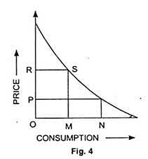
The following model of industrial location was given by
Detailed Solution for TS SET Paper 2 Mock Test - 3 (Geography) - Question 3

The model is representation of Profit Maximization Theory given by August Losch. The primary objective of this theory was to decide the best possible location for industries. Losch rejected Weber’s model completely. He was of the opinion that industries would be located at a place where they would get maximum profit rather than the place with least cost.

Thus, the correct answer is A.

TS SET Paper 2 Mock Test - 3 (Geography) - Question 4
Which of the following are correctly matched?

a) Gravity Model: Measures interactions between all the possible locations pairs.

b) Retail Model: Measures the boundary of the market areas.

c) Potential Model: Measures interactions between central location and peripheral locations.

Choose the correct option:

Detailed Solution for TS SET Paper 2 Mock Test - 3 (Geography) - Question 4

Gravity model is defined as the level of interaction between two locations which is a function of their attributes based on their level of separation. The calculation of the Gravity model is given by Tij= Vi*Wj/S2ij, where Tij is the spatial interaction and this formulae explains the main notion of the Gravity model which basically says the gravitational attraction between 2 regions is directly proportional to the product of the masses of the two regions and inversely proportional to the square of the distance between the 2 regions.

The potential spatial model basically is the level of interaction between one location and all the others which is measured by the summation of the attributes of each other pondered by their level of separation, that is squared to reflect the friction of distance.

The retail model is a bit different than the others. Instead of interactions, it deals with the boundaries. It assumes that the market boundary between two locations is a function of their separation pondered by the ratio of their respective weights. Hence, the calculation is represented by Bij=Sij/1+Wj/Vi.

TS SET Paper 2 Mock Test - 3 (Geography) - Question 5

Which of the following is NOT a theme that influenced Ratzel's work?

Detailed Solution for TS SET Paper 2 Mock Test - 3 (Geography) - Question 5

Answer: 2) Cultural Diffusion.

Friedrich Ratzel was a German geographer, ethnologist, and anthropologist who is considered to be the father of political geography. He was influenced by various themes and ideas during his lifetime, some of which had a significant impact on his work.

Key Points

  •  Among the options provided, cultural diffusion is the theme that did NOT influence Ratzel's work.
  • Cultural diffusion refers to the spread of cultural traits, such as ideas, beliefs, and practices, from one group of people to another.
  • While Ratzel was interested in the relationship between culture and geography, his primary focus was on the role of physical factors, such as climate and topography, in shaping human societies.

Additional Information 

  • The other three options, association and organization, struggle and natural selection, and historical development, were all themes that influenced Ratzel's work.
  • Ratzel believed that human societies were organized and functioned in a similar way to biological organisms, and he used Darwin's theory of evolution to explain the development of human societies.
  • He also emphasized the importance of historical factors in shaping the present-day distribution of human populations and cultures.

Therefore, the correct answer is option 2) Cultural diffusion. Ratzel's work was primarily influenced by themes such as association and organization, struggle and natural selection, and historical development, rather than cultural diffusion.

TS SET Paper 2 Mock Test - 3 (Geography) - Question 6
Which one of the following statements with regard to growth of coral reefs is not correct?
Detailed Solution for TS SET Paper 2 Mock Test - 3 (Geography) - Question 6

Coral Reefs can grow only in the clean salt water of oceans, which lack any kind of instability.

  • Corals thrive in tropical water with a temperature between 23°C-25°C.
  • A fair amount of sunlight for survival.
  • Ideal depth between 45 m to 55 m.
  • No marine pollution.
  • Corals need saltwater to survive and require a certain balance in the ratio of salt to the water. This is why corals don’t live in areas where rivers drain freshwater into the ocean.
TS SET Paper 2 Mock Test - 3 (Geography) - Question 7

Consider the following -

1. Methane

2. Nitrous Oxide

3. Halons

Which of the above is/are responsible for depletion of stratospheric ozone?

Detailed Solution for TS SET Paper 2 Mock Test - 3 (Geography) - Question 7

The correct answer is 1, 2 and 3.

Key Points

  • Ozone layer depletion the reduction of the amount of ozone in the stratosphere.
    • It occurs when chlorine and bromine atoms come into contact with ozone in the stratosphere, they destroy ozone molecules.
    • Ozone-depleting substances (ODS), which include chlorofluorocarbons (CFCs) and hydrofluorocarbons (HCFCs), were once used widely in refrigerants, insulating foams, solvents, and other applications.
    • Other chemicals that damage the ozone layer include methyl bromide (used as a pesticide), halons (used in fire extinguishers), and methyl chloroform (used as a solvent in industrial processes). 
  • Methane can react with other gases to form water vapor, which then breaks down into other chemicals that destroy ozone.
  •  Nitrous Oxide affect Ozone depletion.
    • The compound reacts with high-energy oxygen atoms to produce a deadlier compound, nitric oxide (NO). This then goes on to destroy ozone, a molecule made up of three oxygen atoms.
  • Halons are ozone depleting substances whose production and consumption is controlled under the Montreal Protocol.
    • All halons contain bromine which is 40-100 times more effective at destroying ozone than chlorine.

Additional Information

  • Stratosphere
    •  It is the second layer of the atmosphere found above the troposphere.
    • It extends up to 50 km of height.
    • This layer provides some advantages for flight because it is above stormy weather and has steady, strong, horizontal winds.
    • The ozone layer is found in this layer. The ozone layer absorbs UV rays and safeguards the Earth from harmful radiation.
    • Stratopause separates stratosphere and mesosphere.​ 
TS SET Paper 2 Mock Test - 3 (Geography) - Question 8
The spread of cultural traits from one region to other is called:
Detailed Solution for TS SET Paper 2 Mock Test - 3 (Geography) - Question 8

The correct answer is Diffusion.

Key Points

  • The spread of cultural traits from one region to another is called cultural diffusion.
  • Cultural diffusion often occurs when people move from one place to another.
  • It is the geographical and social spread of the different aspects of one more culture to different ethnicities, religions, nationalities, regions, etc.

Additional Information

TS SET Paper 2 Mock Test - 3 (Geography) - Question 9
Rainwater Harvesting is an effective technique to-
Detailed Solution for TS SET Paper 2 Mock Test - 3 (Geography) - Question 9

The Rainwater Harvesting involves the collection and storage of rainwater at surface or sub-surface aquifers and is a very useful method, particularly for developing countries like India. The above sentences are some of the needs and advantages of rainwater Harvesting and is necessary in areas where ground water levels are declining on regular basis and inadequate.

TS SET Paper 2 Mock Test - 3 (Geography) - Question 10

Which is of the following is negative consequence of migration?

I. It put pressure on social and physical infrastructure in the urban areas

II. It creates anonymity, which creates social vacuum and sense of dejection among individuals

III. Remittances from the international migrants are one of the major sources of foreign exchange

Detailed Solution for TS SET Paper 2 Mock Test - 3 (Geography) - Question 10

Option 2 is correct, i.e I and II.

  • Migration creates both benefits and problems for the areas, people migrate from and migrate to.
  • Consequences can be observed in economic, social, cultural, political and demographic terms
  • A major benefit for the source region is the remittance sent by migrants.
  • Remittances from international migrants are one of the major sources of foreign exchange.
  •  It has serious negative consequences such as anonymity, which creates a social vacuum and a sense of dejection among individuals.
  • A continued feeling of dejection may motivate people to fall into the trap of anti-social activities like crime and drug abuse.
  • Overcrowding of people due to rural-urban migration has put pressure on the existing social and physical infrastructure in the urban
    areas.
  • This ultimately leads to unplanned growth of urban settlement and the formation of slums shanty colonies.
TS SET Paper 2 Mock Test - 3 (Geography) - Question 11

Consider the following terms associated with population studies:

1. Physiological density = total population /net cultivated area.

2. Agricultural density = total agricultural population / net cultivable area.

3. Agricultural population includes only cultivators and agricultural labourers and their family members.

Which of the above statements is/are correct?
Detailed Solution for TS SET Paper 2 Mock Test - 3 (Geography) - Question 11

Some terms associated with population studies:

  • Population data are collected through Census operation held every 10 years in our country. The first population Census in India was conducted in 1872 but its first complete Census was conducted only in 1881.
  • Physiological density = total population /net cultivated area
  • Agricultural density = total agricultural population / net cultivable area
  • Agricultural population includes cultivators and agricultural labourers and their family members.
TS SET Paper 2 Mock Test - 3 (Geography) - Question 12
In the quaternary age what was the evidence of climate change?
Detailed Solution for TS SET Paper 2 Mock Test - 3 (Geography) - Question 12

The quaternary or Pleistocene ice age witness the advance of huge glaciers or ice sheets from different centers. In north America, great glaciers spread out from the centers near the Hudson Bay which buried all set of eastern Canada, New England and much of middle west.

Thus, the Correct answer is A.

TS SET Paper 2 Mock Test - 3 (Geography) - Question 13
Which factor of globalization has largest share in spreading out production of services recent days?
Detailed Solution for TS SET Paper 2 Mock Test - 3 (Geography) - Question 13

Information and communication technology is the factor of globalization has largest share in spreading out production of services recent days.

Important Points

  • Rapid improvement in technology has been one major factor that has stimulated the globalisation process.
  • Even more remarkable have been the developments in information and communication technology.
  • In recent times, technology in the areas of telecommunications, computers, Internet has been changing rapidly.
  • Telecommunication facilities (telegraph, telephone including mobile phones, fax) are used to contact one another around the world, to access information instantly, and to communicate from remote areas.

Information and communication technology (or IT in short) has played a major role in spreading out production of services across countries.

TS SET Paper 2 Mock Test - 3 (Geography) - Question 14
Who compared determinism to the traffic control system?
Detailed Solution for TS SET Paper 2 Mock Test - 3 (Geography) - Question 14

Correct Answer: Taylor.

Key Points

  • Taylor (1880-1963) was more cautious in relating man and the environment.
  • He believed that the environment has set the limits of human development.
  • Their determinism was compared to the traffic control system, which set the rate, but did not give the direction of progress, which came to be known as Neo-determinism or Stop and Go Determinism.
  • He states that man is able to speed, slow, or stop the speed of any country's (regional) development.
  • But he should not be, if he is intelligent, departing from the instructions according to the natural environment.
  • He (man) is like a traffic controller in a big city, which changes the rate but does not give the direction of progress.
  • The environment acts as a controller of traffic.
  • It stops and informs us when we do wrong. Man can speed up, slow down or stop the development program of the country, following the environmental rules, but he cannot go against the plan of the environment.

Additional Information

  • Ellsworth Huntington was a professor of geography at Yale University during the early 20th century, known for his studies on environmental determinism/climatic determinism, economic growth, economic geography, and scientific racism.
  • Ellen Churchill Semple was an American geographer and the first female president of the Association of American Geographers. She contributed significantly to the early development of the discipline of geography in the United States, particularly studies of human geography.
TS SET Paper 2 Mock Test - 3 (Geography) - Question 15
Which of the following theories mention that the political and economic relationships between countries and regions of the world control and limit the economic development possibilities of the poor areas?
Detailed Solution for TS SET Paper 2 Mock Test - 3 (Geography) - Question 15

Dependency theory, another major body of the development theory, which holds that the political and economic relationships between countries and regions of the world control and limit the economic development possibilities of the poorer areas. Some theorists have stated, the colonialism created political and economic structures that caused the colonies to become dependent on the colonial powers. Many poorer countries tie their currency to a wealthy country's currency or by adopting the wealthy country's currency as their own, creating a important link between the poor and the wealthy country's economy.

TS SET Paper 2 Mock Test - 3 (Geography) - Question 16
Which of the following statement best characterizes New International Division of Labour?
Detailed Solution for TS SET Paper 2 Mock Test - 3 (Geography) - Question 16

The New International Division of Labour (NIDL), is the consequence of globalization and is referred to as the characteristic feature of the Post-Fordist era. The high paying jobs are still concentrated in the core economies and the low-paying jobs within the same industry is concentrated in the third world countries. Example, the shoemaking will be done in cottage industries of Bangladesh for large MNCs whose headquarter and the R&D wing is situated in United States.

TS SET Paper 2 Mock Test - 3 (Geography) - Question 17

How many states of India share its border with Bhutan?

Detailed Solution for TS SET Paper 2 Mock Test - 3 (Geography) - Question 17

The Bhutan–India border is the international border separating Bhutan and India. The border is 699 km long, and adjoins the Indian states of Assam (267 km), Arunachal Pradesh (217 km), West Bengal (183 km), and Sikkim(32 km).

TS SET Paper 2 Mock Test - 3 (Geography) - Question 18

What are true in relation to jet stream?

(i) Jet stream blow across Asian Continent at latitudes North of Himalayas parallel to Tibetan highlands.

(ii) Tibetan highland divides jet stream into North and South branches.

(iii) The northern branch of jet stream plays important role in winter weather in India.

Detailed Solution for TS SET Paper 2 Mock Test - 3 (Geography) - Question 18

The correct answer is (i) and (ii) 

Key Points  Jet stream

Higher up in the atmosphere, a different pattern of air circulation is observed during the winter months:

  • All of Western and Central Asia remains under the influence of westerly winds along the altitude of 9-13 km from west to east. These winds blow across the Asian continent at latitudes north of the Himalayas roughly parallel to the Tibetan highlands. These are known as the sub-tropical/tropical westerly jet stream. Hence, statement 1 is correct.
  • Tibetan highlands act as a barrier in the path of these jet streams. As a result, jet streams get bifurcated.
    • One of its branches blows to the north of the Tibetan highlands, while the southern branch blows in an eastward direction, south of the Himalayas, later recombining into a single stream over China.Hence,statement 2 is correct.
  • It is believed that this southern branch of the jet stream exercises an important influence on the winter weather in India.Hence,statement 3 is incorrect.
  • The mean position of this jetstream is about 25°N.

TS SET Paper 2 Mock Test - 3 (Geography) - Question 19
An earthquake is considered as major earthquake when its magnitude ranges
Detailed Solution for TS SET Paper 2 Mock Test - 3 (Geography) - Question 19

Key Points

Earthquake: An earthquake is a sudden shaking or trembling of the earth which lasts for a very short time. It is caused by a disturbance deep inside the earth’s crust.

  • An earthquake is measured with a machine called a seismograph. The power of an earthquake is expressed in terms of magnitude on a scale called the Richter scale.
  • An earthquake of 2.0 or less can be felt only a little.
  • An earthquake over 5.0 can cause damage from things falling.
  • A 6.0 or higher magnitude is considered very strong and 7.0 is classified as a major earthquake.
  • Really destructive earthquakes have magnitudes higher than 7 on the Richter scale.

Hence, an earthquake is considered a major earthquake when its magnitude ranges 6-7.

Additional Information

  • Richter scale is not linear. This means that an earthquake of magnitude 6 does not have one and a half times the destructive energy of an earthquake of magnitude 4.
  • In fact, an increase of 2 in magnitude means 1000 times more destructive energy. Therefore, an earthquake of magnitude 6 has a thousand times more destructive energy than an earthquake of magnitude 4.
TS SET Paper 2 Mock Test - 3 (Geography) - Question 20

Which among the following factors influence the salinity of ocean water?

1. Precipitation

2. Evaporation

3. Ocean Currents

4. Temperature

Select the correct code from the options given below:
Detailed Solution for TS SET Paper 2 Mock Test - 3 (Geography) - Question 20

The correct answer is 1, 2, 3 and 4.

Key Points

Salinity:

  • All waters in nature, whether rainwater or ocean water, contain dissolved mineral salts.
  • Salinity is the term used to define the total content of dissolved salts in seawater.
  • It is calculated as the amount of salt (in gm) dissolved in 1,000 gm (1 kg) of seawater.
  • It is usually expressed as parts per thousand (‰) or ppt.
  • Salinity is an important property of seawater.
  • The main source of Salinity is the dissolution of the rocks of oceanic crust which contains salts
  • The salinity of 24.7ppt (parts per thousand) has been considered as the upper limit to demarcate ‘brackish water'.

Factors affecting ocean salinity:

  • The salinity of water in the surface layer of oceans depends mainly on evaporation and precipitation.
  • Surface salinity is greatly influenced in coastal regions by the freshwater flow from rivers, and in polar regions by the processes of freezing and thawing of ice.
  • Wind also influences the salinity of an area by transferring water to other areas.
  • The ocean currents contribute to the salinity variations.
  • Salinity, temperature and density of water are interrelated.
  • Hence, any change in the temperature or density influences the salinity of water in an area.

Evaporation:

  • It is higher at places with high rates of evaporation.

Temperature:

  • Regions with high temperatures have waters with high salinity.
  • Variations in the density or temperature affect the salinity of water in that area.

Precipitation:

  • It shares an inverse relationship with salinity.
  • Regions with higher levels of precipitation have lower levels of salinity.

Ocean Currents:

  • It affects the spatial distribution of salts in the ocean by mixing sea waters.
  • Variations in the salinity of the ocean water also contribute to the formation of ocean currents.

The Influx of Fresh Water:

  • There is a negative relationship.
  • The salinity of oceans decreases with more influx of fresh water from rivers to oceans.
  • In the Polar region, the surface salinity is influenced by the processes of freezing & melting of ice.


Thus, Precipitation, Evaporation, Ocean Currents and Temperature all influence the salinity of ocean water.

Additional Information

TS SET Paper 2 Mock Test - 3 (Geography) - Question 21
The East-West Corridor connects which of the following cities?
Detailed Solution for TS SET Paper 2 Mock Test - 3 (Geography) - Question 21

The East-West corridor has been built to connect the cities of Silcher in Assam and Porbandar in Gujrat. The length of roads in the corridor is 3300 km. The corridor is a part of North-South-East-West Corridor, the largest ongoing highway project in the country.

Thus, the correct answer is D.

TS SET Paper 2 Mock Test - 3 (Geography) - Question 22
Read the following statements and choose correct answer from the code given below:

(a) The laterite soils are used as building material.

(b) The forest soils are rich in humus.

(c) The forest soils are deficient in potash, phosphorus, and lime.

(d) Kari is a type of soil found in Kerala.

Detailed Solution for TS SET Paper 2 Mock Test - 3 (Geography) - Question 22

The forest soils are rich in humus and lack potash, phosphorus, and lime. Therefore, they require a good deal of fertilizers for high yields. The laterite soils are used as building material. Kari is a type of Peaty soil in the Kottayam and Alappuzha districts of Kerala.

TS SET Paper 2 Mock Test - 3 (Geography) - Question 23
Who tried to combine the three branches of geography general, mathematical and physical, and, chorology in his book ‘Geographia Generalis’?
Detailed Solution for TS SET Paper 2 Mock Test - 3 (Geography) - Question 23

Correct Answer: Varenius.

Key Points

  • This was followed by another exclusive volume on the religions of Japan.
  • However, Varenius’ most significant contribution was his book, ‘Geographia Generalis’ (1650) which was one of the first attempts to combine three branches of geography—general (systematic), mathematical and physical—and, chorology (the science of space).
  • This book consisted of three parts:
    • The absolute or terrestrial part deals with the shape and size of the earth as well as the physical geography of continents, seas, and the atmosphere. 
    • The relative or the cosmic part describes the relation between the earth and other celestial bodies especially the sun and its effects on global climate. 
    • The comparative part focuses on the principles of navigation and the location of different places in relation to each other. 
  • In the preface of Geographia Generalis, Varenius advocated that the description of particular places should take into consideration the:
    • Celestial conditions—climate,
    • Terrestrial conditions—relief, soil, vegetation, and biotic life,
    • Human conditions—population, settlement, trade, forms of government. 

Important Points 

  • Geographia generalis (1650), Varenius’s best-known work, sought to lay down the general principles of geography on a wide scientific basis according to the knowledge of the day.
  • It not only was systematic geography on a scale not previously attempted but also contained a scheme for special, now known as regional, geography.
  • That major work was frequently revised, and the edition of 1672 had improvements by Sir Isaac Newton.
  • Varenius’ Geographia Generalis could have had a second volume but it could not be completed owing to his untimely and premature death in 1650. This book was translated into several editions in Latin.
TS SET Paper 2 Mock Test - 3 (Geography) - Question 24
Which of the following waves is used in the process of remote sensing?
Detailed Solution for TS SET Paper 2 Mock Test - 3 (Geography) - Question 24

Explanation :

The waves used in common TV remote control are Infrared Rays.

  • Infrared (IR), sometimes called infrared light, is electromagnetic radiation (EMR) with wavelengths longer than those of visible light. 
  • Infrared Rays are Electromagnetic waves.
  • It is therefore invisible to the human eye.
  • IR is generally understood to encompass wavelengths from the nominal red edge of the visible spectrum around 700 nanometers (frequency 430 THz) to 1 millimeter (300 GHz) (although the longer IR wavelengths are often designated rather as terahertz radiation).
  • Black-Body Radiation from objects near room temperature is almost all at infrared wavelengths.
  • As a form of electromagnetic radiation, IR propagates energy and momentum, with properties corresponding to both those of a wave and of a particle, the photon

Additional Information

  •  An X-ray, or X-radiation, is a penetrating form of high-energy electromagnetic radiation. Most X-rays have a wavelength ranging from 10 picometers to 10 nanometers, corresponding to frequencies in the range 30 petahertz to 30 exahertz and energies in the range 124 eV to 124 keV.
  • Ultraviolet (UV) is a form of electromagnetic radiation with a wavelength from 10 (with a corresponding frequency around 30 PHz) to 400 nm (750 THz), shorter than that of visible light, but longer than X-rays. UV radiation is present in sunlight and constitutes about 10% of the total electromagnetic radiation output from the Sun. It is also produced by electric arcs and specialized lights, such as mercury-vapour lamps, tanning lamps, and black lights.
  • A Gamma-ray, or gamma radiation, is a penetrating form of electromagnetic radiation arising from the radioactive decay of atomic nuclei. It consists of the shortest wavelength electromagnetic waves and so imparts the highest photon energy.
TS SET Paper 2 Mock Test - 3 (Geography) - Question 25
Which among the following is a true statement?
Detailed Solution for TS SET Paper 2 Mock Test - 3 (Geography) - Question 25

The true statement among the given options is: Inner planets are made up of rocks. Important PointsInner planets, also known as terrestrial planets, are composed mainly of rocks and metals.

  • These planets are located closer to the Sun compared to the outer planets.
  • The inner planets in our solar system are Mercury, Venus, Earth, and Mars. They have solid surfaces and are primarily composed of materials such as silicates, iron, and other rocky substances.

On the other hand, the outer planets, also known as gas giants or giant planets, are primarily composed of gases like hydrogen and helium.

  • They are much larger in size compared to the inner planets. The outer planets in our solar system are Jupiter, Saturn, Uranus, and Neptune.

Therefore, the statement "Inner planets are made up of rocks" is true.

TS SET Paper 2 Mock Test - 3 (Geography) - Question 26
Which one of the following is the correct sequence of cultural change as given by Lewis Mumford?
Detailed Solution for TS SET Paper 2 Mock Test - 3 (Geography) - Question 26

Lewis Mumford gave 6 stage of cultural change of town in his theory of origin of towns. These were Eoplis is a rising village. Polis is a small market town. Metropolis has specialized activities and a sphere of influence. Megalopolis is wealth-dominant city. Tyrannopolis has wealth but also abundance of crimes. Necropolis is the city of dead, with environmental problems.

Thus, the correct answer is A.

TS SET Paper 2 Mock Test - 3 (Geography) - Question 27

Choose the correct option regarding 'Immigration'.

(A) People may move within a country or between countries

(B) People who leave a country

(C) When a person enters a new country.

Detailed Solution for TS SET Paper 2 Mock Test - 3 (Geography) - Question 27

The correct answer is Only C.

Key Points

  • Immigration is a process through which individuals become permanent residents or citizens of another country.
  • Historically, the process of immigration has been of great social, economic and cultural benefit to states.
  • It is the international movement of people to a destination country of which they are not natives or where they do not possess citizenship in order to settle as permanent residents or naturalised citizens.

 Thus, we can say that Immigration is when a person enters a new country.

TS SET Paper 2 Mock Test - 3 (Geography) - Question 28

Consider the following statements:

1. Seamounts are isolated steep submarine hills

2. The Andaman and Nicobar Islands are parts of seamounts projecting above the sea level.

3. The Peru Trench has been formed by subduction of the Nazca Plate below the South American plate.

4. Romanche Gap divides the Mid Pacific Ridge into two parts.

Which of the above statements is/are true?

Detailed Solution for TS SET Paper 2 Mock Test - 3 (Geography) - Question 28

Seamount:

  • It is a mountain with pointed summits, rising from the seafloor that does not reach the surface of the ocean.
  • Seamounts are volcanic in origin. These can be 3,000-4,500 m tall.
  • The Emperor seamount, an extension of the Hawaiian Islands in the Pacific Ocean, is a good example.

Andaman and Nicobar Islands are the southern extension of the Himalayan ranges which have come into being due to the submerging of the intervening lowlands. They owe their origin partly to the volcanic eruptions.

The Peru–Chile Trench, also known as the Atacama Trench, is an oceanic trench in the eastern Pacific Ocean delineating the boundary between the subducting Nazca Plate and the overriding South American Plate.

Romanche Gap, also called Romanche Deep, or Romanche Trench is a narrow submarine depression lying near the Equator in the mid-Atlantic Ocean and trending east-west between the shoulders of South America and Africa.

TS SET Paper 2 Mock Test - 3 (Geography) - Question 29
Which of the following question is related to the causal relationships between features?
Detailed Solution for TS SET Paper 2 Mock Test - 3 (Geography) - Question 29

The correct answer is Why.

Key Points

  • A causal relationship exists when one variable in a data set has a direct influence on another variable. Thus, one event triggers the occurrence of another event.
  • A causal relationship is also referred to as cause and effect that realization to why.
  • Causal relationships in real-world settings are complex, and statistical interactions of variables are assumed to be pervasive (e.g., Brunswick 1955, Cronbach 1982). This means that the strength of a causal relationship is assumed to vary with the population, setting, or time represented within any given study, and with the researcher's choices about treatments and measurement of outcomes.
  • Without a sensitive assessment of such interactions, true effects can be obscured or causal claims can be overgeneralized to a wider range of people, settings, times, treatments, or outcome constructs than is warranted. Unfortunately, the number of possible interactions is endless, posing problems to the analyst that are insuperable, at least in theory (Cook 1993).
  • The practical task is to assess the most plausible interactions within a given research area. Interactions occur often between treatment, populations, measures, and context, posing the most plausible threats to external validity (Campbell and Stanley 1966, Cook and Campbell 1979). Because external validity specifies the conditions under which an internally valid relationship can be reproduced, threats to external validity necessarily invoke internal validity.
  • A causal generalization, e.g., that smoking causes lung cancer, is not about a particular smoker but states a special relationship exists between the property of smoking and the property of getting lung cancer.
  • To establish causality you need to show three things–that X came before Y, that the observed relationship between X and Y didn't happen by chance alone, and that there is nothing else that accounts for the X -> Y relationship.
TS SET Paper 2 Mock Test - 3 (Geography) - Question 30
Volcanoes are classified on the basis of nature of eruption and the form developed at the surface. Which of the following is NOT a type of Volcano?
Detailed Solution for TS SET Paper 2 Mock Test - 3 (Geography) - Question 30

The correct answer is Compound Volcanoes.

Key Points

  • Compound Volcanoes
    • ​A complex volcano is also called a compound volcano or a volcanic complex.
    • It is a mixed landform consisting of related volcanic centers and their associated lava flows and pyroclastic rock.
    • They may form due to changes in eruptive habit or in the location of the principal vent area on a particular volcano.
  • Thus, it is not a type of volcano in itself.

Additional Information

  • Volcanoes are classified based on the nature of eruption and the form developed at the surface.
    • Shield Volcanoes are the largest of all the volcanoes on the earth, which are not steep and are mostly made up of basalt.
    • Composite Volcanoes are characterized by outbreaks of cooler and more viscous lavas than basalt and are constructed from numerous explosive eruptions.
    • Calderas are known as the most explosive volcanoes on Earth and when they erupt, they incline to collapse on themselves rather than constructing any structure.
    • Flood Basalt Provinces volcanoes discharge highly fluid lava that flows for long distances.
    • Mid-Ocean Ridge Volcanoes are found in the oceanic areas and the central region of this ridge gets frequent eruptions.
View more questions
Information about TS SET Paper 2 Mock Test - 3 (Geography) Page
In this test you can find the Exam questions for TS SET Paper 2 Mock Test - 3 (Geography) solved & explained in the simplest way possible. Besides giving Questions and answers for TS SET Paper 2 Mock Test - 3 (Geography), EduRev gives you an ample number of Online tests for practice

Top Courses for TS TET

Download as PDF

Top Courses for TS TET